
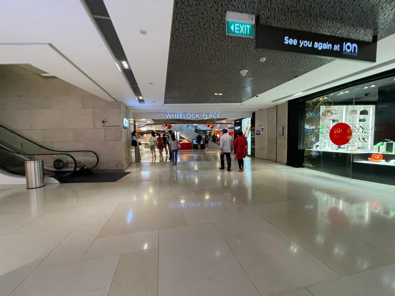
Can you walk between Orchard Road shopping malls underground? Yes, there are useful connections in parts of the district, including the ION Orchard–Wheelock Place link near Orchard MRT, but there is no reason to assume every mall from Orchard to Somerset connects through one continuous tunnel. The practical starting point is the actual building you want and the current station or mall signs. Underpasses may reduce rain and heat exposure while still requiring lifts, escalators or outdoor crossings for the complete journey.
Orchard MRT serves the North South Line (NS22) and Thomson–East Coast Line (TE14). Its current directory lists ION and Wheelock Place under Exit 5, Wisma Atria and Ngee Ann City under Exit 3, and Tang Plaza and Shaw House among the Exit 1 destinations. Those exit numbers help you navigate but do not independently certify a fully step-free route to every shop, cinema or hotel.
The main photograph is eduKateSG’s actual October 2026 image of the ION Orchard–Wheelock Place underground passage, supported by a second image of an Orchard MRT shopping corridor. This article distinguishes photographed existing links, URA’s planning vision and older proposed tunnels, because an obsolete network diagram can otherwise mislead visitors relying on shelter or accessibility.
Orchard Road underground links: quick guide
- ION Orchard–Wheelock Place: photographed underground pedestrian passage in the October 2026 media collection.
- Orchard MRT Exit 5: SMRT lists ION Orchard and Wheelock Place as destinations.
- Orchard MRT Exit 3: SMRT lists Wisma Atria and Ngee Ann City.
- Orchard MRT Exit 1: destination cluster includes Shaw House and Tang Plaza.
- ION Orchard Link: CapitaLand identifies a B2 underground shopping passage.
- 313@somerset: direct basement 2 connection to Somerset MRT (NS23), a separate station.
- Some additional links appear on older URA planning maps; do not assume every proposal is open.
- A sheltered link is not automatically a fully step-free route; confirm the lifts you need.
- Follow on-site signs during maintenance, weather changes or construction.

How the Orchard Road underground links actually work
An underground pedestrian link is a passage connecting basement areas, MRT facilities or neighbouring developments without requiring the same journey to be made at street level. The upper Orchard Road precinct includes an underground network around ION Orchard, Orchard MRT and Wheelock Place, alongside other connections and building entrances. It is not one continuous tunnel that gives unrestricted access to every mall in the entire district.
The correct question is not simply ‘Is Orchard Road underground?’ but ‘Which building am I starting from, which destination do I need, and what route is currently signed?’ A passage that reaches Wheelock Place may not automatically deliver you to Paragon, Ngee Ann City or a particular hotel floor. Buildings have different levels and private areas.
Choose the destination first and follow the station and building signs. The October 2026 photographs document existing links, but real access can change with repairs or management instructions.
ION Orchard and Wheelock Place: the photographed connection
eduKateSG’s October 2026 media library contains a clearly identified photograph of the ION Orchard underground link to Wheelock Place. Shoppers are walking through the passage, with commercial activity and wayfinding around them. This is the most direct photographic evidence used in the article because the named link actually appears in the image.
Wheelock Place is at 501 Orchard Road, while ION Orchard is at 2 Orchard Turn. The connection is particularly useful when you are already in the Orchard MRT precinct and want to visit both places without choosing a complicated outdoor route. However, the photo does not establish the exact accessible path to every floor.
Follow the current signs for Wheelock Place or ION, and locate the relevant lifts if stairs or escalators are unsuitable. A visible underpass is not automatically a full barrier-free route.
Orchard MRT Exit 5: a practical navigation clue
SMRT’s current exit directory names both Wheelock Place and ION Orchard under Exit 5. That gives visitors an authoritative way to identify the general connection without relying on old lettered exit descriptions. Other numbered Orchard exits serve additional destinations, so Exit 5 is not a universal recommendation for every mall.
If you are meeting a friend at Wheelock Place, agree on a specific point in the retail building rather than simply say ‘Exit 5’. A station exit can have several approaches or levels and may be crowded during busy shopping periods.
Read current station signs because exit routes may be affected by construction or a lift outage. The best usable route may involve more than the shortest-looking arrow on a printed old map.
The Orchard MRT underground shopping passage
Another October 2026 photo shows an underground shopping passage near Orchard MRT with shops and pedestrians. This is a typical example of how a transit connection becomes part of a retail environment. A passenger may move from station signs to mall signs without immediately noticing the change of property boundary.
Commercial kiosks and shopfronts make the walk more interesting, but they can also make wayfinding confusing. If you are unfamiliar with the district, keep the name of your destination in mind and stop at an appropriate space to check directions when the corridor divides.
The photograph documents the passage’s appearance at that time. It should not be used as a substitute for current wayfinding or as proof that each nearby development is directly linked.

ION Orchard Link at Basement 2
CapitaLand’s 2024 material on ION Orchard describes the B2 ION Orchard Link and includes a photograph of the shopping passage, showing how underground pedestrian movement and retail use connect. This is a useful official complement to eduKateSG’s own Orchard MRT passage photographs.
A branded link is both a circulation route and a commercial space. People may be catching trains, returning from work or browsing shops. The design therefore has to support movement while allowing retail storefronts to remain visible.
For a smooth journey, avoid stopping in the middle of the passage to take a wide group photograph. Step aside in an appropriate place and allow commuters to continue using the connection.

The current SMRT exit list: why numbered exits matter
SMRT’s Orchard station guide lists thirteen numbered exits and destination groups. Exit 1 includes a large Orchard/Scotts cluster with Tang Plaza, Shaw House and Scotts Square; Exit 3 lists Wisma Atria and Ngee Ann City; Exit 5 lists Wheelock Place and ION. Several further exits serve other ION or Paterson Road approaches.
An exit number is a navigation aid, not a promise that the whole route is step-free. The directory may include several destinations under one exit even when the appropriate street crossing or building entrance differs. Check your own mobility needs and the particular destination.
If an older blog gives a lettered exit that conflicts with current numbered signs, follow the operator’s live wayfinding. Retail complexes and stations can change their labels over time.

Wisma Atria from Orchard MRT Exit 3
Wisma Atria at 435 Orchard Road is one of the buildings SMRT lists under Exit 3. It contains Food Republic on Level 4 and various retail and dining businesses. That makes Exit 3 a useful starting point for a meal or shopping stop on the Wisma side of the precinct.
But the word ‘exit’ does not tell you whether every desired Wisma floor is reached through a fully sheltered, step-free sequence. Follow current directions to the appropriate lift or internal level. The photographed broad exterior steps are visually interesting but are not suitable for everybody.
If your companion uses a stroller or wheelchair, look for the accessible approach before attempting a staircase. A slightly longer route can be more comfortable.

Ngee Ann City from the same Exit 3 destination group
SMRT also lists Ngee Ann City with Wisma Atria at Exit 3. The building houses Takashimaya Shopping Centre and the department store, including Books Kinokuniya on Level 4. A station exit serving two landmarks does not make those landmarks one building or ensure the same internal lift bank reaches both.
Read the signs for the actual shop you want. Someone collecting a book may need a different floor and meeting point from a visitor going to the Takashimaya Basement 2 Food Hall. The correct level matters even more when the route crosses from public circulation into retail property.
For an outdoor architectural photograph, the broad Ngee Ann City frontage remains an option when weather and mobility permit. Do not force that portion of the walk during heavy rain.

Shaw House and Tang Plaza: distinguish documented links from assumptions
Shaw House at 350 Orchard Road and Tang Plaza form part of the large Orchard/Scotts shopping junction. Historical URA circulars have referred to existing underground pedestrian links between developments in this area, illustrating the long-standing goal of pedestrian connectivity.
However, an archived planning or grant document is not a 2026 operations map. It cannot prove that every named route is currently open or that the easiest path leads to a particular cinema, hotel lobby or department-store counter. The practical wayfinding on site takes priority.
For visitors attending Shaw Theatres Lido, identify Shaw House and the cinema’s Levels 5 and 6 first. A shopping underpass is only one part of the actual journey to the auditorium.
Planned versus completed connections: an important distinction
URA’s archived 2021 materials list proposed underground links among properties such as Paragon, Ngee Ann City, Lucky Plaza and Mandarin Gallery, together with existing connections identified for upgrades. Those records describe planning intentions and possible network improvements, not a guarantee that every proposed tunnel had been built and opened.
A guide that reproduces a historic proposal as a live 2026 walking map could send somebody towards an unavailable passage. That is particularly problematic during bad weather or for a visitor relying on step-free access. Always distinguish a planned link, a photographed existing link and a currently accessible public route.
The current URA design guidelines describe the network’s intended connectivity and public-access principles, but on-site signs remain necessary for an actual journey.
URA’s 2026 vision: links on several different levels
The Urban Redevelopment Authority’s Orchard urban-design guidelines, updated in September 2026, describe pedestrian movement at street level, underground and elevated levels. The goal is a connected, walkable shopping district with sheltered routes between developments, transit facilities and public spaces.
This explains why Orchard Road is more complicated than a simple strip of shopfronts. There are underground corridors, ground-level covered walks, plazas and selected elevated connections. Together they provide different paths depending on weather, destination and user needs.
The urban-design vision is not a universal statement that every existing mall has a completed fully sheltered connection to every neighbour. Planning standards and actual operating conditions must be understood separately.
Underground, street-level and elevated routes are different things
An underground link is below street level, an at-grade covered walkway runs beside the road or through a building at ground level, and an elevated link connects higher floors. Orchard’s planning framework recognises all three. A route planner showing two connected buildings may not explain which level the passage occupies.
Before moving, check whether the route involves lifts or escalators. Somebody comfortable with stairs may choose one path while a wheelchair user needs another. A stroller may require more turning space than a single traveller with no luggage.
A route can be sheltered without being step-free, and it can be step-free without remaining fully indoors. Those distinctions are essential to good practical guidance.
The direct Somerset MRT connection is a separate system
313@somerset at 313 Orchard Road connects directly with Somerset MRT, NS23, at Basement 2 according to the mall’s official information. This is a separate station-linked shopping environment farther down the Orchard corridor; it should not be described as the same underground network or station as Orchard MRT.
Visitors whose main destination is 313 should usually choose Somerset MRT rather than arrive at Orchard MRT simply to explore tunnels. The direct B2 link is one reason 313 can be convenient during Singapore’s hot or rainy weather.
The connection to a station does not guarantee every neighbouring mall can be reached by a continuous covered basement passage. Check the exact building-to-building route.

Why the linked corridors contain shops
URA’s design guidelines encourage activity-generating uses alongside public pedestrian links, including shops and food businesses. This can make a transit corridor feel lively and useful rather than a purely utilitarian tunnel. Passengers may stop for a drink, buy something small or find an entrance to another retail level.
The same activity can make a connection feel busy. People going to work may be walking quickly while other visitors are deciding which shop to enter. Keep main paths and lift landings clear, especially when stopping to read a map or take a photograph.
A good pedestrian environment supports both movement and brief pauses without making one group obstruct the other.
Are Orchard Road underground walkways free to use?
Many publicly accessible station links and shopping corridors can be used without buying anything, provided they are open and visitors follow property rules. However, using a passage should not be confused with entering the paid MRT area, a private hotel facility or a ticketed attraction.
Public access may be limited to specific operating hours, while shops within the passage follow their own schedules. URA’s 2026 guidelines discuss public network access during MRT operating hours unless otherwise specified, but any particular route may be affected by maintenance or management instructions.
Never assume a locked side door is a shortcut simply because an old map shows a connection. Follow the permitted wayfinding and ask staff when uncertain.
Accessibility: a tunnel photo is not a lift audit
eduKateSG’s image of the ION-to-Wheelock link confirms the visible corridor at the time of photography. It does not establish which lifts serve the route or whether every nearby shop entrance is accessible to a particular mobility device. The same limitation applies to photographs of escalators and station foyers.
If accessibility is essential, trace the journey from platform to concourse, lift, corridor, mall entrance and final floor. Check lift status and alternative arrangements with SMRT or building staff. Do not attempt to carry a wheelchair or stroller down a staircase simply to avoid a longer route.
Accurate route information makes a neighbourhood more welcoming. A confident but unsupported claim of complete accessibility is less useful than clear steps for verifying the actual connection.

Strollers and children in underground passages
Families may appreciate sheltered shopping corridors because they avoid some exposure to sun and rain. Yet the space can be busy with commuters, storefront queues and turns between levels. A stroller needs enough room to move without blocking the main passage.
Choose suitable lifts rather than using an unsafe escalator shortcut. Explain the meeting point to older children and keep younger ones close in crowded corridors. A brightly lit shopping connection can still be confusing when several signs point in different directions.
Plan a short route and a food stop rather than making every connected mall a compulsory destination. The outing should fit the family’s energy.

Older visitors and people with reduced stamina
An underground link can reduce outdoor walking but may increase indoor distance through a large mall. Somebody with limited stamina might find a direct authorised taxi drop-off more comfortable than a long corridor with several escalators or lift waits.
Ask which part of the route is most demanding before choosing the entrance. A step-free path is not automatically a short path. Seats, restrooms and a clear return route are useful practical considerations.
Enjoy one destination and a suitable meal instead of insisting on covering the whole network. Comfort matters more than the number of linked properties.
Rain and lightning: the safe way to use links
During ordinary rain, an appropriate indoor passage can make travel more comfortable. However, reaching the entrance may still involve an exposed pavement or crossing. Heavy rain, slippery steps and lightning can create risks that should not be ignored simply because there is a sheltered route somewhere ahead.
Move into suitable substantial shelter and wait when conditions are severe. Do not sprint through a dangerous outdoor section to reach a mall because the plan says the next part is underground. The correct response is to adapt the itinerary.
After rain eases, check whether a wet entrance or temporary barrier changes the route. The best shortcut is one that remains safe and accessible.
Is every Orchard Road mall linked all the way to Somerset?
No. Orchard Road stretches across distinct clusters, and the underground connections near Orchard MRT are not one uninterrupted publicly verified tunnel through every mall to Somerset. The direct Somerset MRT connection at 313 is a separate access system.
Some historical planning maps show proposed connections among additional developments. Those should not be used to claim a live, complete pathway without confirming construction and current public access. Visitors should plan realistic outdoor segments and marked crossings when necessary.
An honest guide saves readers from arriving at an assumed link that does not exist or is closed. When in doubt, consult current operator signs and accept a safe surface route.

Finding Wheelock Place without getting lost
From the Orchard MRT and ION precinct, follow the current signs naming Wheelock Place and consider Exit 5 as a useful location clue. The exact floor route may branch around shops, so stop in a safe space to check signs when the path changes direction.
Wheelock’s distinctive conical glass exterior is an excellent way to confirm your destination after reaching street level. If you emerge at a different exit, do not cross the road impulsively; look for the appropriate signed crossing or return to an indoor direction point.
A simple plan works best: station, selected exit or link, named building and clearly agreed meeting point.

A short ION–Wheelock shopping walk
Choose ION Orchard as the first destination, enjoy its architecture and perhaps a food or shop stop, then follow the signed link towards Wheelock Place. This gives you two distinct commercial environments without making the whole district a compulsory walk.
If the link is closed or the suitable lift is unavailable, adapt. You may choose a safe surface crossing, a different station route or simply finish at ION. There is no need to make a two-building plan inflexible.
The photographed October corridor is a useful visual reference for the experience, not a guarantee of uninterrupted access on all later dates.
A 60-minute indoor-first Orchard outing
Arrive at Orchard MRT, choose ION as the main indoor anchor and use current signs for the part of the mall you want. Have a small meal, browse one shop or look at a current exhibition if available. If the group wants an extra stop, follow an appropriate link towards Wheelock; otherwise return through the station.
The route minimises unnecessary outdoor movement and can be pleasant during warm weather. But the first and last parts still depend on your station entrance and travel arrangements.
One comfortable indoor destination is enough for a good hour in Singapore’s shopping belt. The purpose is enjoyment, not accumulating mall names.
Choosing underground routes for a film at Shaw House
Shaw Theatres Lido is inside Shaw House on Levels 5 and 6. If your outing includes a fixed movie, prioritise the correct cinema entrance and hall over exploring underground connections. You may choose a basement food stop at Shaw House before heading up.
Historical links around Tang Plaza and Shaw House have existed in the shopping precinct, but their current path should be checked on-site rather than reconstructed from an archived architectural proposal. A film’s start time is not flexible simply because a shopper enjoys exploring tunnels.
Leave a time buffer for lifts, escalators and the cinema’s ticketing process. A calm arrival makes the movie much more enjoyable.

The role of underground pedestrian links in city design
Singapore’s urban designers aim to make central shopping areas walkable and connected. Underground links reduce some conflicts between pedestrians and surface traffic and can create sheltered routes, while street-level crossings and open public spaces remain essential to the neighbourhood.
Commercial development and public movement intersect in these passages. The spaces can improve convenience while also encouraging people to see shops they might otherwise pass. That is an example of how transport infrastructure and retail economics shape one another.
Students can observe the difference between the directness of a route and the number of retail opportunities along it. A corridor is more than a shortcut when it supports many purposes.
An underground-link photography exercise
Take one wide image that clearly shows the corridor and overhead signage, then a closer photograph of a material or wayfinding detail. Compare the image with an outdoor view of Wheelock’s glass cone. The pair tells a story about how architecture works above and below street level.
Do not obstruct commuters for a dramatic symmetrical photograph, and follow any photography rules in privately managed corridors. A natural composition can include moving pedestrians without making identifiable strangers the focal subject.
Caption the images conservatively: ‘ION Orchard–Wheelock Place underground link, October 2026’ is more useful than pretending a photograph proves a fully step-free journey.

A practical wayfinding checklist before entering a tunnel
Write down your destination building, intended floor and the exit or connection currently identified by the operator. Confirm whether you need lifts and whether the station or mall has a public-information point where staff can assist. This small preparation is particularly valuable when travelling with children, wheelchairs or luggage.
At each branch, follow the destination name instead of the crowd. People moving in the same direction may be going to an unrelated exit or shop. If a corridor is unexpectedly closed, seek the signed alternative rather than try a restricted door.
Before finishing, identify the station entrance or legal vehicle pick-up that suits your actual endpoint. A linked shopping precinct is easier to enjoy when the return journey is clear.
Frequently asked questions about Orchard Road underground links
Is there an underground link from ION Orchard to Wheelock Place?
Yes. eduKateSG photographed the link in October 2026, and Orchard MRT Exit 5 lists both destinations.
Which Orchard MRT exit goes to Wheelock Place?
SMRT identifies Wheelock Place and ION Orchard under Exit 5, although other routes may also be possible.
Does Orchard MRT have numbered exits?
Yes. SMRT’s current directory lists exits 1 to 13, with different destination groups.
Which Orchard MRT exit serves Wisma Atria?
Exit 3 lists Wisma Atria and Ngee Ann City in the current SMRT station directory.
Which exit serves Tang Plaza and Shaw House?
SMRT includes both in the Exit 1 destination group, subject to current wayfinding.
Is ION Orchard Link located on Basement 2?
CapitaLand identifies the B2 ION Orchard Link as an underground shopping and pedestrian passage.
Is 313@somerset linked to Orchard MRT?
No. It has a separate direct B2 link to Somerset MRT (NS23), not the Orchard station interchange.
Can I walk entirely underground from Orchard to Somerset?
Do not assume so. The precinct has different links and some sections may require outdoor travel.
Are the corridors open all night?
Access depends on the individual operator, station timetable and any specified exceptions or maintenance.
Are every underpass and linked lift wheelchair-accessible?
A building may have accessibility features, but the exact lift-to-destination route needs current checking.
Can I take a stroller through the ION–Wheelock passage?
An underground pedestrian link exists, but check current lifts, route widths and other access needs before relying on it.
Does an older URA planning map prove a tunnel was built?
No. Planning proposals and completed public links are different and should not be confused.
Is public access to a station-linked corridor free?
Many publicly accessible pedestrian passages can be used without buying anything, but paid station and private areas follow separate rules.
Are shops located along Orchard underground passages?
Yes. Retail frontages form part of underground pedestrian environments near the station.
Can the passages help during a rainy day?
Yes where an appropriate sheltered route exists, but some approaches remain outdoors and lightning safety must take priority.
Is Wheelock Place the same property as ION?
No. They are separate neighbouring developments with their own retail levels and entrances.
Who can help if the accessible route is blocked?
Ask SMRT staff or the relevant mall’s concierge for the current permitted alternative.
Do these photos certify lift or corridor access today?
No. They are October 2026 records of real passages and buildings, not live access or maintenance reports.
Enjoy the city above and below Orchard Road
Orchard’s underground passages are useful parts of a wider pedestrian district. They connect commuting, retail, shelter and architecture in everyday life. Choose a realistic route, enjoy the shops or public spaces that interest you and avoid treating an older planned link as a guaranteed shortcut.
A comfortable visit begins with knowing where you are going and leaves room for the unexpected. The right connection is the one that works safely for the people travelling with you.
Continue with Orchard Road rainy-day activities and Orchard Road food courts near MRT exits for another useful side of the Orchard Road experience.
Official planning, station and Orchard Road sources
SMRT Orchard station exits and destination groups
URA 2026 Orchard urban-design guidelines and underground network policy
CapitaLand: ION Orchard and B2 ION Orchard Link
URA archived 2021 proposed links, for historical context only
313@somerset official direct MRT access
Orchard MRT exit and mall guide
Orchard Road wheelchair and stroller guide
How to reach Orchard Road by MRT and bus
Wheelock, Wisma and other Orchard Road architecture
One-day Orchard Road itinerary
Updated October 2026. The photos document named passages and buildings but do not certify real-time access, lift status, opening hours or continuous step-free paths. Historical URA proposals are explicitly identified as planning information, not confirmed completed tunnels.