
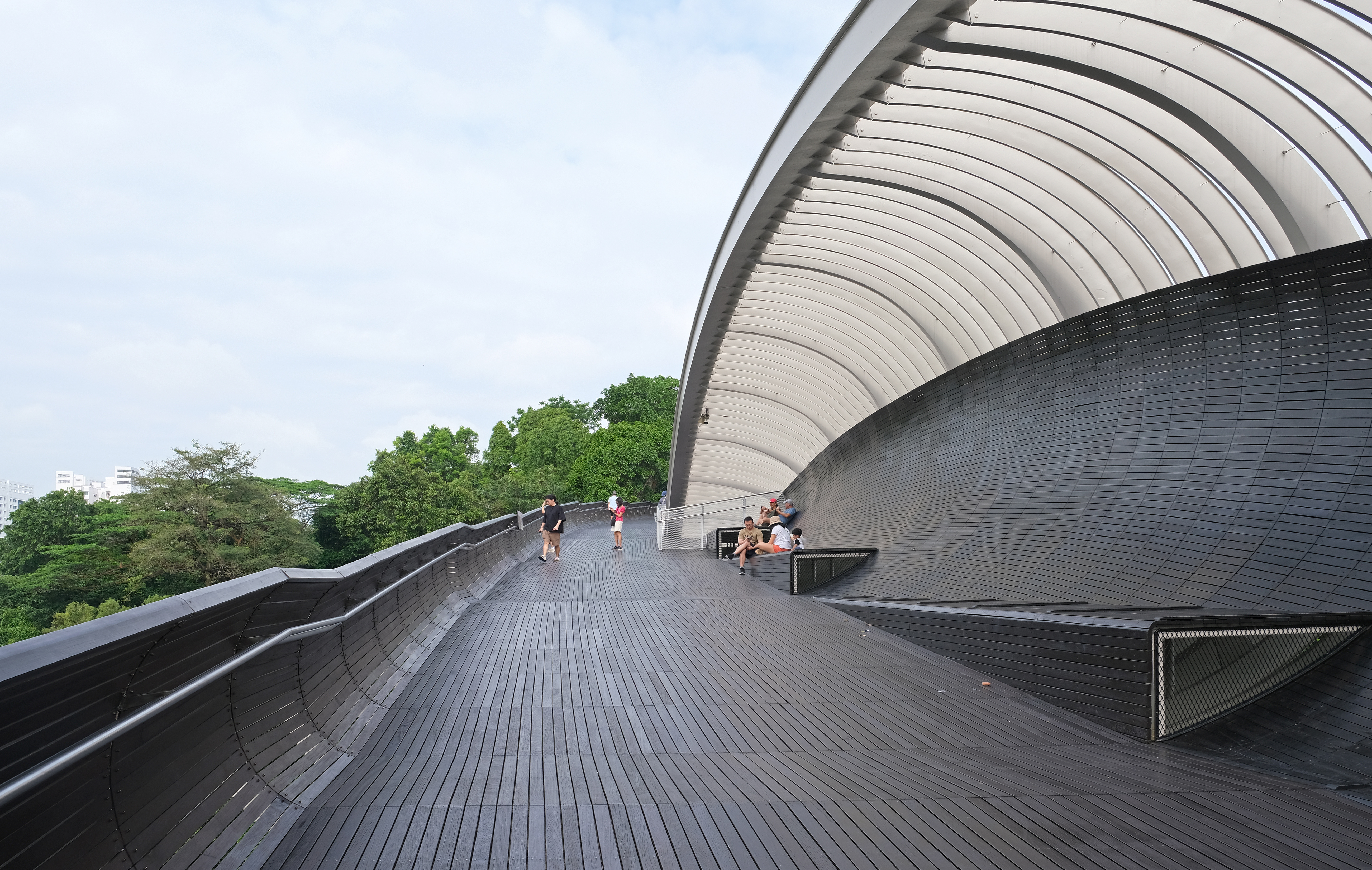
The best free things to do in Bukit Merah are to enjoy the views from Henderson Waves, explore suitable public paths at Mount Faber Park and visit Telok Blangah Hill Park for greenery and birdwatching. Henderson Waves is a 274-metre pedestrian bridge connecting Mount Faber Park with Telok Blangah Hill Park. It is free to cross under normal public access, but the hill approaches involve slopes and steps, and NParks lists no wheelchair access at either hill park.
A November 2026 plan must account for several distinct works. The Mount Faber Loop has a footpath closure following slope failure, and Mount Faber Car Park D is affected by stabilisation works. Parts of Forest Walk can be unlit at night until 30 November 2026, while a separate path near the Telok Blangah Hill therapeutic garden is closed for slope repairs until the projected 31 March 2028 date. The southern Rail Corridor has additional temporary closures near Henderson Road. These are route restrictions, not a claim that every hill park or Henderson Waves is closed.
- Best free landmark: Henderson Waves, a 274-metre wave-shaped bridge, illuminated 7pm–2am.
- Best high viewpoint: Faber Point at Mount Faber Park, with a mini Merlion and history murals.
- Best short but steep access: Marang Trail from near HarbourFront MRT, about 700m and 15 minutes uphill with stairs.
- Best forest atmosphere: Telok Blangah Hill Park, with parts of the elevated Forest Walk and a higher Terrace Garden.
- Daylight safety: Earth Trail is not for entry after 7pm, and Forest Walk lighting/closure notices need checking.
- Accessibility warning: NParks explicitly marks Mount Faber and Telok Blangah Hill Parks as not wheelchair accessible.
- Nearby longer option: 1.7 km Henderson Park Connector, a separate surface route linking Alexandra Road and Telok Blangah Way.
- Do not rely on old maps for Mount Faber Loop, parts of Forest Walk or Rail Corridor South.
This is a practical guide in the eduKateSG Bukit Merah collection, complementing Things to do in Singapore | Bukit Merah, Henderson Waves and the Southern Ridges transport guide. Choose one reasonable experience first; the full Southern Ridges network is not a compulsory family itinerary.
Quick decisions: which Bukit Merah outing should you choose?
- For an iconic photograph: visit Henderson Waves in safe weather and use a practical approved approach.
- For panoramic harbour views: go to Faber Point, with a suitable hill climb or transport plan.
- For birdwatching: a daylight visit to a currently open Forest Walk section.
- For an older relative: avoid prescribing a steep hill; consider a more accessible lower-level community or park-connector option.
- For a first family nature walk: choose one viewpoint and a clear return route rather than the entire ridgeline.
- For rainy weather: postpone exposed elevated bridges and choose a sheltered indoor venue elsewhere in the district.
1. Bukit Merah has several different kinds of landscape
Bukit Merah is a large planning area that includes residential neighbourhoods, hill parks, transport corridors and the waterfront-facing slopes of southern Singapore. The names Mount Faber, Telok Blangah, Henderson and HarbourFront often appear together, but the distance and elevation between destinations affect how a family should plan.
An easy shopping trip near HarbourFront is not equivalent to a hill trek via Marang Trail. A park connector along Henderson Road is different from walking over Henderson Waves high above the road. The same district can offer a short flat trip and a strenuous afternoon, depending on which feature the group actually wants.
Choose a goal before selecting a station. A parent with a stroller or grandparent may find a lower-level option more comfortable than the hilltop. A confident teenager may enjoy a longer trail. A good guide explains those differences rather than implying every place called Bukit Merah lies beside a single entrance.
2. Henderson Waves: the signature free viewpoint
Henderson Waves is a 274-metre-long pedestrian bridge that links Mount Faber Park to Telok Blangah Hill Park. NParks describes its curving structure as seven wave-like ribs creating sheltered alcoves. The bridge stands about 36 metres above Henderson Road, which explains why it provides such a different view from the traffic beneath.
An ordinary public crossing does not require a commercial admission ticket. Visitors can enjoy the timber decking, curved design and surrounding greenery from appropriate places. The bridge itself is not a reason to lean over railings or enter closed sections for a more dramatic photograph.
The important planning detail is the approach. Reaching a high bridge may require steps or a climb, so a visitor should investigate the actual entrance rather than assuming an elevated bridge is accessible simply because its decking looks smooth. NParks Henderson Waves guide.
3. The seven ribs and why the bridge looks like a wave
From below and from the pedestrian deck, Henderson Waves is recognisable for its repeated curving forms. The ribs offer areas to rest and change how the structure looks from different directions. They are a good subject for photography, but also for an elementary question about how architecture combines movement, shelter and a memorable visual identity.
Ask children whether a bridge must be flat in appearance to be useful. The deck connects two pieces of land across a road, but the surrounding structure adds a distinct experience. That is an example of engineering and design meeting public recreation.
Stay within normal pedestrian areas and leave room for people crossing. Resting in an alcove should not block the main deck, and large photo groups should be considerate of others. A shared public landmark remains pleasant when no one treats it as a private set.
4. Henderson Waves by night: lights and limitations
NParks states that the bridge is illuminated daily by LEDs from 7pm to 2am. It can look especially striking after sunset, but lighting the bridge does not mean every connecting trail is appropriate at night. The adjacent Earth Trail in Telok Blangah Hill Park is not to be entered after 7pm, and some Forest Walk sections have separate temporary lighting restrictions.
If you want the evening bridge atmosphere, choose a legal, clearly lit approach and know how you will leave. Families should not improvise a long forest route in darkness because one illuminated structure appears on a map. A late-night plan may be unsuitable for young children or older relatives.
Weather also matters. An elevated bridge is exposed to rain and lightning, so postpone the crossing during thunderstorms. The best time for a first visit may simply be a clear morning when the access route is easier to see.
5. Mount Faber Park: free scenery with real elevation
Mount Faber Park covers about 56 hectares and is one of Singapore’s older hill parks. NParks describes it as open 24 hours and part of the Southern Ridges. It offers views over the harbour, southern coast and islands, along with forested slopes and historical features.
The park is free to enter during ordinary public access. The existence of a paid cable car at the wider Mount Faber Peak area does not make the hillside park a ticketed attraction. A family can choose a public viewpoint without purchasing a cable car trip, subject to how it reaches the site.
NParks explicitly marks the park as having no wheelchair access. That is a critical limitation, not a minor note to hide beneath a list of beautiful photographs. The right plan depends on the actual visitor’s mobility, route and comfort. Mount Faber Park official page.
6. Marang Trail: 700 metres that can feel longer
The Marang Trail begins near the Seah Im Food Centre carpark area at the base of Mount Faber. NParks describes the route as a 700-metre footpath and staircase taking approximately 15 minutes to climb. That estimate is suitable for a capable walker, but it is not a promise for every child, older person or visitor unused to tropical humidity.
Steps, heat and the descent matter. Before committing, ask whether everyone is comfortable climbing and coming down again. A toddler may require frequent pauses and a person with knee difficulties may prefer not to attempt the route. Skipping the climb can be the sensible decision.
Active visitors should bring water, wear suitable shoes and choose daylight or a clearly understood route. A hill is not a competition, and the reward of the view is not worth pushing someone to continue when they are uncomfortable.
7. Faber Point: a city view with a story
NParks identifies Faber Point as the highest point in Mount Faber Park, with panoramic views, a mini Merlion and a commemorative tree linked to Singapore’s first Tree Planting Day. Below the lookout is a mural wall depicting parts of Singapore’s development from fishing village to modern city.
This combination makes Faber Point suitable for a thoughtful shorter visit if the approach is manageable. A child can observe different kinds of movement: ships, roads, cable cars and the distant city. Then they can see how the mural tells the place’s history through images.
Do not assume a landmark is open as an indoor venue or that all nearby commercial experiences are free. The public viewpoint and a paid meal or cable car are separate choices. A satisfying day may consist of the scenery and a calm return.
8. The mini Merlion and local symbolism
The small Merlion at Faber Point is not the larger tourist landmark at Merlion Park near Marina Bay. It is part of Mount Faber’s own viewpoint landscape. Children sometimes confuse similar iconic statues, so identify the actual place rather than telling them they have visited the Marina Bay attraction.
Ask what a symbol communicates and why it might be reproduced in several locations. The Merlion combines animal forms associated with Singapore’s identity, but a symbol is not the same thing as a historical photograph. Distinguishing representation from literal evidence helps children interpret public art.
Photography is welcome from safe public areas, but do not climb on decorative features or lean past barriers to get a certain angle. The experience should remain relaxed and considerate of other visitors.
9. Mount Faber Loop closures in 2026
NParks has published route notices following a slope failure affecting a footpath on Mount Faber Loop between the Henderson Waves side and the cable car area. Car Park D also has a slope-stabilisation closure projected through December 2026, with alternatives indicated by the agency. These restrictions affect particular paths and access arrangements, not the existence of the whole park.
Before setting off, use the most recent NParks park notices and map. A saved trail screenshot may show a route that has since been fenced. Do not bypass barriers or follow an informal slope because a navigation app still draws a continuous line.
Families with young children should be especially careful about detours that add stairs. A route described as short before construction may become strenuous when the alternative crosses steeper ground. Change the plan or choose another viewpoint when necessary.
10. Telok Blangah Hill Park: separate from Mount Faber
Telok Blangah Hill Park lies off Henderson Road at Telok Blangah Green and covers about 34 hectares. It connects to Henderson Waves and the wider Southern Ridges, but it has its own forest trails, terrace garden and recreational facilities. Its general park hours are 24 hours, except that visitors should not enter the Earth Trail after 7pm.
NParks explicitly marks no wheelchair access for the hill park. It should not be advertised as a universally accessible nature outing merely because some paths look level in photographs. Families should select a specific route and check slope and stairs before travelling.
The park can be an enjoyable place to observe forest canopy, birds and city views. A leisurely visit may centre on one public viewpoint rather than a complete network walk. Telok Blangah Hill Park official page.
11. Terrace Garden: a different hilltop view
The Terrace Garden in Telok Blangah Hill Park has semicircular landscape terraces and a panoramic hilltop perspective. NParks describes it as offering 360-degree views, making it a popular photography location. The terraces create a different visual experience from the long span of Henderson Waves.
A family can spend time noticing how the terraces shape movement and sightlines. Older children may ask why a garden is built in steps across a slope rather than flattened into one large lawn. The answer connects hillside design, landscape and available terrain.
Consider how to reach the viewpoint. A person who struggles with slopes should not be forced towards a terrace because the photograph looks tranquil. An enjoyable outing is one whose approach and return are comfortable, not merely one with a beautiful destination.
12. Forest Walk: 1.3 kilometres through the canopy
NParks describes the Forest Walk as a 1.3-kilometre elevated path where visitors can experience tree canopies and potentially observe birds. The typical walking estimate is around 35 minutes on a normally open section. The experience differs from walking on the more challenging ground-level Earth Trail.
However, the Forest Walk has had slope-repair closures in recent years and October 2026 notices state some sections are unlit from 7pm to 7am through 30 November 2026. Older descriptions of an uninterrupted, illuminated walkway are unreliable. Check the current notice and use only the open, signed segments.
This makes a daylight route more suitable for most families. A person may enjoy a short forest view without attempting the whole path, particularly if diversions make the return longer than expected. NParks birdwatching and Forest Walk information.
13. Earth Trail: not a shortcut after sunset
The Earth Trail is the more challenging ground-level option through Telok Blangah Hill’s forest. NParks specifically says not to enter it after 7pm. It can contain uneven terrain and natural surfaces that are inappropriate for many mobility-limited visitors.
A family that has enjoyed the bridge lights should not attempt to return by an unlit or closed Earth Trail. Select the legal illuminated approach in advance and check whether maintenance has changed the route. During or immediately after heavy rain, forested slopes can be unsafe.
Children may wonder why one park is listed as open 24 hours but a nature trail has shorter hours. Explain that park-wide access and particular habitat rules are different. The distinction protects both wildlife and people.
14. A separate path closed to March 2028
NParks’ notices identify a footpath below the Telok Blangah Hill therapeutic garden closed for slope works from June 2025, with expected completion on 31 March 2028. This is a specific closure, not a statement that the entire therapeutic garden or whole hill park is unavailable.
Check the currently provided alternative path before setting off. Worksite barriers should be respected even if the official projected completion date is later revised. Detours can include stairs or extra distance, affecting family members who did not plan for a demanding hike.
A static photograph of the path from an older article cannot establish access today. This is why practical guides should give readers the agency page and a clear warning rather than claiming a route is always open.
15. The 2026 Rail Corridor South closure
NParks’ Rail Corridor FAQ updated in September 2026 states that the southern section between Henderson Road and Spooner Road, including an area near Block 138 Jalan Bukit Merah, is temporarily closed for improvement works. That matters because some Southern Ridges visitors attempt to combine an elevated walk with the rail corridor in one long day.
The closure requires a separate route or an alternative plan. Do not assume the rail corridor is a continuous public trail at the southern end simply because other sections are open. Consult the current map and choose a safe crossing or turnaround point.
Active walkers may enjoy a different open part of the network, but families should never enter fenced track beds or unstable slopes. See the official Rail Corridor FAQ before planning a long interconnected journey.
16. Henderson Park Connector: 1.7 kilometres at street level
The Henderson Park Connector is a 1.7-kilometre route running from Alexandra Road to Telok Blangah Way along Henderson Road. NParks links it with several surrounding green spaces and schools. It is not the same thing as the elevated Henderson Waves bridge, and a visitor should not treat the two names as interchangeable.
A family that prefers neighbourhood walking might choose a short segment of the connector with an easy return. The full 1.7 kilometres is optional; actual walking effort includes travel from the start point and back. The route remains useful even for visitors who do not wish to climb the hills.
Choose proper crossings and observe shared-path etiquette. Cyclists, pedestrians and schoolchildren can all use nearby spaces at different speeds. Official Henderson Park Connector route.
17. The Southern Ridges are larger than a bridge walk
The Southern Ridges connect several southern parks and landscapes. A full route from Mount Faber through Telok Blangah, HortPark and farther west can cover many kilometres. An older travel guide may turn this into a single half-day suggestion, but the actual difficulty depends on heat, elevation, weather and the open sections.
Before choosing a long itinerary, decide whether the group wants a single landmark or a substantial hike. Most families can enjoy Henderson Waves without committing to an entire network traversal. A teenager interested in hiking can plan a longer route, but must still check closure notices.
Good planning preserves energy for the return. A scenic destination feels less enjoyable when a family discovers too late that the path to transport is steep or blocked. Treat the entire Southern Ridges as a collection of choices rather than one required walk.
18. Birdwatching and seasonal changes
NParks describes birds that may be seen along the Forest Walk and from Henderson Waves, including common forest species and migrating raptors. October and November can be interesting months to watch birds of prey moving south, while other sightings vary. No particular bird is guaranteed.
An observer does not need specialist equipment. Stop in a safe public place, look quietly at the sky or canopy, and describe shape, flight or calls before attempting a species identification. Binoculars can help but are not essential for the first experience.
Do not approach nests or leave permitted routes for a better photograph. Wildlife observation should be based on patience rather than interference. A child may learn more from noticing a single bird carefully than from collecting many uncertain names.
19. A free park does not make the cable car free
Mount Faber Park and Henderson Waves are public attractions without a general entrance ticket. The Singapore Cable Car, operated commercially at Mount Faber Peak and connecting towards Sentosa, is a separate paid transport and tourism experience. A free-first guide should not blur the distinction.
A family may enjoy views from permitted public park areas and leave without buying a cable car ticket. Another may choose the ride as a special occasion and budget accordingly. Neither choice is inherently better; the purpose of a useful guide is to help readers decide knowingly.
Commercial prices, operating hours and promotional packages change. If the cable car is central to the outing, check its operator directly rather than relying on an old quoted fare.
20. What to bring for a hill walk
A short flat walk and a hill climb require different preparation. For Mount Faber or Telok Blangah, choose suitable shoes, carry drinking water and consider sun, humidity and stairs. A child who is comfortable on a playground may still tire on repeated uphill steps.
Identify where the group can turn back before starting. Know which path is closed and where the current alternative goes. A family walking after lunch in strong heat may prefer a shorter route or a different outing altogether.
Do not treat a phone’s walking-time estimate as a guarantee. Steep sections, crowding, breaks and weather affect real travel time. A slow, pleasant trip with rest is preferable to a rushed route that no one enjoys.
21. A child-friendly Henderson Waves outing
Imagine parents with an eight-year-old who wants to see the famous wooden bridge. Make the bridge the day’s principal destination, choose a suitable approach and allow time to rest. The child may enjoy seeing the wave-like design and looking down at the road more than completing several kilometres of forest trail.
Parents should keep children within railings and avoid games that involve running along the deck. If the bridge is crowded, step aside carefully and keep the group together. An afternoon that ends after the bridge and a meal can be a successful family day.
Ask one question about the design, such as why a bridge might need both a safe walking surface and places for people to rest. The answer can connect creativity and practical engineering.
22. A teenage Bukit Merah nature challenge
Teenagers may prefer preparing a route through the Southern Ridges, but should be asked to check closures rather than simply copy an online map. Give them responsibility for noting the Mount Faber Loop diversion, Forest Walk lighting conditions and the separate path closure near the therapeutic garden.
They can also prepare a plan B if weather becomes unsafe or a signed route is unavailable. This is a meaningful test of judgment. It encourages a student to understand the difference between theoretical distance and a walk that can legally and safely be completed today.
Photography, birdwatching and writing can enrich the outing, but none should require a dangerous detour. The strongest field observation often comes from one carefully chosen open viewpoint.
23. Why the two hill parks are not wheelchair-accessible outings
NParks explicitly states there is no wheelchair access at Mount Faber Park and Telok Blangah Hill Park. This remains true even though some carparks have designated parking lots and particular surfaces look smooth in photographs. The presence of a car bay or a short paved section is not a guarantee of a continuous barrier-free route to a viewpoint.
Families should take this limitation seriously and choose a different activity where needed. A lower-level park connector or other accessible public space may give a visitor a pleasant outdoor experience without forcing an unsuitable hill approach. Check the specific route before departing.
Accessibility means being able to participate comfortably and return safely, not merely reaching an attraction at any cost. A trustworthy guide states the obstacle clearly so nobody is placed in an awkward or unsafe position.
24. Rain, lightning and exposed crossings
The bridge and elevated routes offer wonderful views partly because they are exposed. During lightning, leave these areas and seek substantial shelter. A small open alcove is not equivalent to a safe indoor refuge. Heavy rain can also make timber decking and stairs slippery.
Do not enter forested slopes during or immediately after severe weather. Slope failures have caused previous closures in this network, and the current repair notices show why maintained barriers are important. Follow on-site instructions even when a saved route map appears shorter.
If the forecast is poor, choose a different indoor or low-level outing in Bukit Merah. The decision to postpone a view is reasonable and protects the family for a future enjoyable visit.
25. A heritage lesson without extra tuition
Mount Faber’s murals, the nutmeg tree near Henderson Waves and the hillside views offer small connections to Singapore’s history. A child can ask what was planted here before the present park, why roads run beneath bridges, and how a harbour shapes a city’s economy.
Use plain descriptions before specialist vocabulary. Words such as canopy, ridge, viewpoint, plantation, slope and connector become clearer when attached to something seen. An older student can distinguish a factual sign from a hypothesis about how the landscape changed.
The purpose is curiosity, not turning leisure into homework. A five-minute conversation about one visible feature can be more useful than asking children to memorise every trail name.
26. Free-first budgeting for Bukit Merah
An ordinary public park walk and Henderson Waves crossing require no admission ticket, but transport, meals, parking at other venues and commercial attractions can cost money. NParks lists free parking at Mount Faber and Telok Blangah Hill Park, subject to availability and specific carpark closures. Do not treat free parking as proof that the route is accessible.
Choose a primary free activity and set an optional budget for food or a cable car ride. If the plan is simply a scenic walk, bring water and enjoy it without adding purchases. A child does not need commercial entertainment for the day to feel special.
A calm discussion of costs before leaving home reduces pressure to buy things on the way. The most valuable part of a hill walk may be the view and shared time, both of which can be enjoyed without a ticket.
27. Choose a shorter route and return another day
Bukit Merah’s southern parks are connected, but the connections can be steep, long or affected by works. A family may enjoy Henderson Waves one weekend, Faber Point another, and a daytime section of Forest Walk later. This is a better way to learn the area than an exhausting one-day attempt to cover every park.
Returning at different times may reveal changing bird activity, a different light on the bridge or improved route access once works are completed. Check official notices before each trip because projected completion dates can change. A past experience is not a guarantee that all the same paths remain open.
The point of a good estate guide is to help visitors choose what genuinely suits them. One safe, memorable viewpoint is worth more than an ambitious itinerary that the group cannot comfortably finish.
Four workable Bukit Merah itineraries
An iconic bridge morning
Choose a confirmed open approach to Henderson Waves, take in the 274m bridge and return safely. Keep the plan short if children or older relatives are travelling.
Faber Point and Mount Faber history
For capable walkers, use the Marang Trail with water and suitable shoes, then view Faber Point’s murals. Check Mount Faber Loop closures before combining this with Henderson Waves.
Daylight birdwatching
Choose an actually open section of Telok Blangah Hill’s Forest Walk, inspect closure maps, and leave before the lighting restriction. Skip the Earth Trail after 7pm.
A lower-level neighbourhood stroll
Use a suitable open segment of the 1.7km Henderson Park Connector if the hill parks are too steep. Plan crossings, the return and an optional meal rather than forcing an inaccessible viewpoint.
Frequently asked questions about Bukit Merah
What are the best free things to do in Bukit Merah?
Visit Henderson Waves or suitable public viewpoints in Mount Faber or Telok Blangah Hill, subject to current trail access.
Is Henderson Waves free?
Yes, ordinary use of the public pedestrian bridge has no ticket charge.
How long is Henderson Waves?
NParks lists the bridge at 274 metres.
How high is Henderson Waves?
It stands roughly 36 metres above Henderson Road.
When is Henderson Waves lit up?
NParks lists LED lighting from 7pm to 2am daily.
Are all the connecting trails lit at night?
No. The Earth Trail is off limits after 7pm and some Forest Walk sections have temporary lighting restrictions.
Is Mount Faber Park free?
Ordinary public park access is free; the cable car and commercial dining are separate paid choices.
How long is Marang Trail?
About 700m and 15 minutes for capable walkers, including stairs and a climb.
Which MRT station is best for Mount Faber?
HarbourFront is a common starting point for Marang Trail; the specific access and return route should be checked.
Is Mount Faber wheelchair accessible?
No. NParks explicitly states there is no wheelchair access.
Is Telok Blangah Hill Park wheelchair accessible?
No. NParks lists no wheelchair access.
What is Faber Point?
A high viewpoint with a mini Merlion, history murals and panoramic southern views.
What is the Forest Walk?
An elevated 1.3km route through forest canopy; check current closures and after-dark lighting.
Can I use Earth Trail after 7pm?
No. NParks states that visitors should not enter after 7pm.
Is Forest Walk fully open in November 2026?
Do not assume a continuous route. Check current slope-repair and lighting notices for the specific section.
Which Telok Blangah path is closed to 2028?
A footpath below the therapeutic garden has a slope-works notice with expected completion in March 2028.
Is Mount Faber Car Park D available?
It has been affected by slope-stabilisation works with an expected completion around December 2026; check the current notice.
Is the southern Rail Corridor open?
A section between Henderson Road and Spooner Road is temporarily closed for improvements, according to NParks’ September 2026 FAQ.
How long is Henderson Park Connector?
NParks lists it at 1.7km from Alexandra Road to Telok Blangah Way.
What should families do when it rains?
Leave exposed bridges and slopes during lightning, choose substantial shelter and postpone the outdoor plan.
Further eduKateSG reading
- Things to do in Singapore | Bukit Merah
- Henderson Waves Walking Guide
- Mount Faber and Southern Ridges Transport
- Telok Blangah Hill Park and Therapeutic Garden
- Things to do near HarbourFront MRT
Official references and photograph credit
Updated 7 November 2026. NParks sources: Mount Faber Park, Telok Blangah Hill Park, Henderson Waves, Henderson Park Connector and Rail Corridor South closure. Check the latest slope-repair, carpark and Forest Walk lighting notices before walking; projected completion dates are not reopening guarantees. Featured archival photograph of Henderson Waves: kallerna / Wikimedia Commons, 10 January 2026, original under CC BY-SA 4.0, unchanged.
