
Quick answer: A thoughtful first visit to the British Virgin Islands pairs Tortola’s Road Town and Cane Garden Bay with a protected hill walk at Sage Mountain, then devotes proper time to Virgin Gorda’s great granite boulders at The Baths and the history of the Copper Mine. A longer journey can include Gorda Peak or North Sound, Anegada’s flat coral landscape, Jost Van Dyke’s harbours, Norman Island’s caves and the shipwreck history of RMS Rhone near Salt Island.
The BVI is a British Overseas Territory comprising many islands and cays. A visitor is not touring a single connected resort: the largest islands have distinct geology, community life, historical sites, national parks and sea connections. Tortola is the administrative and business centre; Virgin Gorda contains The Baths; Anegada is very low and coral-derived; and smaller islands are accessed by boats whose operation depends on weather. Learning these contrasts makes the journey more rewarding than simply chasing ten beach photographs.
Some destinations demand specialist skills. The Baths includes wet granite passages, ladders and narrow walking sections, while shipwreck diving is not a casual snorkelling excursion. Mooring, anchoring and marine-park rules protect reefs. Build an itinerary around a few islands that fit your available days, and verify current National Parks Trust tickets, ferries, park openings, vessel safety requirements and entry rules before travel.
eduKate · World heritage and learning
Choose your reading route through the British Virgin Islands
Ten places, three island groups and important protected-area access rules.
ROUTE 1 · PLACES 1–3
Tortola: civic culture, bays and protected hills
Choose where to begin, then use Next to continue.
ROUTE 2 · PLACES 4–6
Virgin Gorda: granite, copper heritage and northern landscapes
Choose where to begin, then use Next to continue.
ROUTE 3 · PLACES 7–10
Anegada, Jost Van Dyke and boat-only marine destinations
Choose where to begin, then use Next to continue.
Choose your ten places
The places are not a ten-stop day tour. Island crossings, tides and park restrictions determine what visitors can do.
| Place | What makes it different? |
|---|---|
| 1. Road Town and J.R. O’Neal Botanic Gardens, Tortola | Road Town is the BVI’s principal administrative centre and a working Caribbean harbour town. |
| 2. Cane Garden Bay and Tortola’s coastal heritage | Cane Garden Bay is one of Tortola’s recognisable sheltered beaches, with restaurants, local services and a history connected to the island’s working landscape. |
| 3. Sage Mountain National Park, Tortola | Sage Mountain National Park protects part of Tortola’s highland environment and offers a strong contrast with low beach destinations. |
| 4. The Baths and Devil’s Bay, Virgin Gorda | The Baths National Park is famous for enormous granite boulders that create grottos, passages and tidal pools along Virgin Gorda’s coast. |
| 5. Copper Mine National Park, Virgin Gorda | The Copper Mine on Virgin Gorda is a preserved industrial heritage site that gives the island’s history another dimension beyond beaches. |
| 6. Gorda Peak and North Sound, Virgin Gorda | Gorda Peak National Park protects a hill environment above the island’s coastline, while North Sound is renowned for the seafaring and harbour landscape to the northeast. |
| 7. Anegada and its coral-reef coastline | Anegada differs geologically from the other major islands: the BVI Tourism Board describes it as a low coral island within a predominantly volcanic chain. |
| 8. Great Harbour and White Bay, Jost Van Dyke | Jost Van Dyke is known for its small harbours, White Bay and beach hospitality, but a responsible visit takes account of the island community and the practical use of boats. |
| 9. Norman Island’s coastal caves and marine setting | Norman Island’s coast and famous caves are often discussed in connection with Caribbean sailing and literary treasure stories. |
| 10. RMS Rhone Marine Park near Salt Island | The wreck of RMS Rhone, a steamship lost in an 1867 hurricane, is one of the BVI’s most significant maritime heritage and diving sites. |
1. Road Town and J.R. O’Neal Botanic Gardens, Tortola
Why this place deserves time. Road Town is the BVI’s principal administrative centre and a working Caribbean harbour town. Its streets, ferry links, market activities and public buildings offer an introduction to the territory as a living society, not simply a charter-yacht base. The J.R. O’Neal Botanic Gardens, managed by the National Parks Trust, provide an accessible complement: plants and interpretation illustrate island vegetation, cultivation and protection. Combining the town and garden helps balance commercial geography with nature study.
What to notice. At the harbour, observe how ferry passengers, freight, local businesses and recreational vessels use different parts of the waterfront. In the garden, notice changes between shaded and more open plant displays and read labels before identifying a species. Botanical interpretation can explain why some plants are native, endemic or introduced, and why those distinctions matter. Do not assume an attractive public building or pier is open without current permission.
The learning question. Draw a small map between the commercial harbour and the botanic garden. Ask how importing goods to multiple islands differs from moving supplies across one city. Then choose one well-labelled plant and compare what the garden says about its habitat with the conditions you observe. Separating geographic facts, botanical explanation and visitor impressions leads to a stronger learning journal.
Access and planning
Use current operating hours and ticket guidance from the National Parks Trust rather than assuming botanic gardens open on every cruise arrival day. Road Town traffic and ferry loading create busy areas where pedestrians must keep clear. Ask before photographing workers and respect public-versus-private boundaries. Set aside a town-and-garden half day rather than treating the capital as just the location of a boat departure.
2. Cane Garden Bay and Tortola’s coastal heritage
Why this place deserves time. Cane Garden Bay is one of Tortola’s recognisable sheltered beaches, with restaurants, local services and a history connected to the island’s working landscape. It offers an opportunity to examine how coastline, fishing, hospitality and older agricultural histories intersect. Nearby historic sites, including the Callwood Rum Distillery when open, can provide context for sugar-related production. A responsible account of these places acknowledges that colonial plantation economies relied upon enslaved labour and that contemporary local enterprise has its own identity.
What to notice. From a lawful public beach access point, compare the protected curve of the bay with more exposed coast elsewhere on Tortola. Watch how small craft and swimmers occupy separate areas and how storm or season affects wave conditions. If an historic production site is operating for visitors, pay attention to machinery and documented history rather than treating the visit as a sales stop. Local livelihoods should be observed respectfully, not photographed without consent.
The learning question. Ask what factors made a bay useful for boats and coastal settlement. Draw the shoreline and mark land uses visible from a public route. With an appropriately interpreted historic distillery exhibit, compare the stages of cane cultivation and processing with the social and economic histories of people forced to work on plantations. Geography and difficult history belong in the same explanation.
Access and planning
Check current beach facilities, local transport and any heritage venue opening independently. Parking and traffic may be busy when several boats arrive. Ocean conditions still vary in an apparently sheltered bay, and a popular venue does not create automatic swimming safety. Keep clear of working docks and avoid entering privately owned heritage structures without permission.
3. Sage Mountain National Park, Tortola
Why this place deserves time. Sage Mountain National Park protects part of Tortola’s highland environment and offers a strong contrast with low beach destinations. Its forest trails demonstrate how elevation and exposure influence the distribution of vegetation. The National Parks Trust administers the protected site, so access and ticketing should be treated as regulated rather than assumed. A walk here can introduce the effect of rainfall, cloud, tree canopy and human land use on a small island.
What to notice. Follow currently open trails and observe how light and humidity change beneath forest cover. Look for the relationship between roots, slope and surface water rather than merely trying to recognise individual trees. Different conditions can produce slippery stones and roots. A hilltop viewpoint is not guaranteed to be clear: mist and cloud may reduce visibility even when conditions near the coast look sunny.
The learning question. Compare the forest to a dry coastal scrub environment and ask why plant communities can differ over short horizontal distances. Describe what you actually notice about canopy and moisture, then check the National Parks Trust’s explanation of habitats. A contour-map exercise illustrates why a short-looking hill route may take longer and demand more physical effort than a similarly long beach walk.
Access and planning
Consult the National Parks Trust’s up-to-date tickets, opening, trail status and safety instructions. Wear suitable hiking shoes and take water, insect protection and a weather-aware return plan. Do not follow unmarked side tracks or ignore closure signs. A shorter authorised nature trail can be a better family choice than pushing toward a summit in poor footing.
4. The Baths and Devil’s Bay, Virgin Gorda
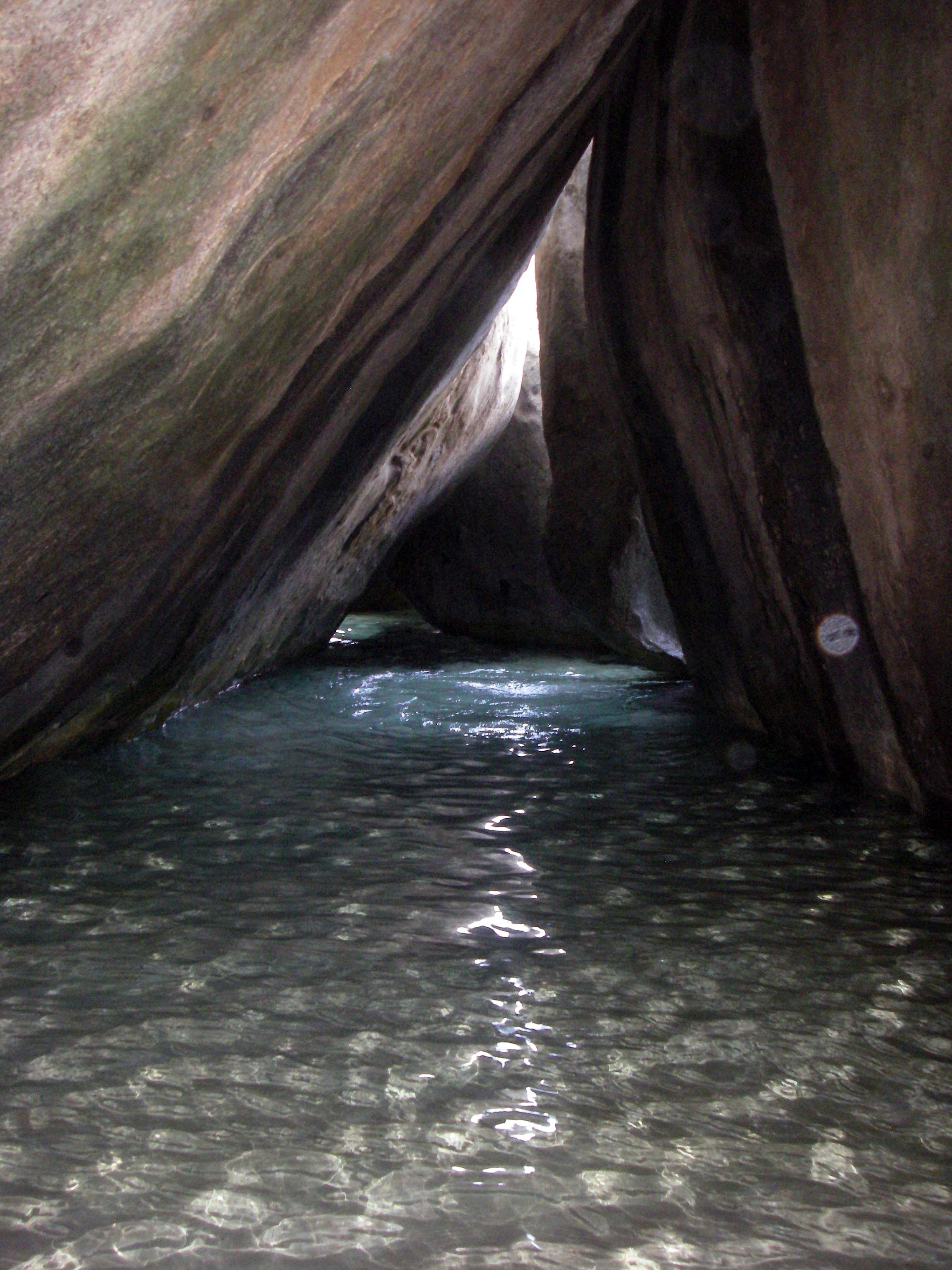
Why this place deserves time. The Baths National Park is famous for enormous granite boulders that create grottos, passages and tidal pools along Virgin Gorda’s coast. The neighbouring Devil’s Bay National Park extends the nature experience to a beach connected by trails. These are real protected areas with visitor management and tickets, not an unregulated natural water park. The contrast between hard granite forms, sand and waves provides excellent material for geological observation, while the narrow passages require deliberate physical care.
What to notice. Notice rounded boulder shapes, joints and water-worn rock surfaces from safe permitted routes. The trail between sites can require climbing, ducking, ladders and wading. The National Parks Trust specifically warns that people must be prepared for these conditions, and a seemingly tranquil pool can change with sea state. Never squeeze through closed passages, climb dangerously on boulders or assume that water depth is predictable.
The learning question. Sketch two rock profiles and propose how fractures and long-term weathering might produce distinct shapes. Identify which geological conclusions require expert support rather than an assumption based on smoothness. The difference between a granite-boulder coast and the coral character of Anegada creates a useful next comparison. Park management also raises a conservation question: why do visitor trails and mooring buoys protect a fragile shore?
Access and planning
Check park tickets and access hours through the National Parks Trust, and confirm the route’s condition before arriving. Avoid wet-rock scrambling beyond your ability; children and people with mobility concerns may need a simpler viewpoint. Boaters must use authorised moorings and current permits where required instead of dropping anchors on coral. Strong swell is reason to postpone, not to take an unapproved shortcut.
5. Copper Mine National Park, Virgin Gorda
Why this place deserves time. The Copper Mine on Virgin Gorda is a preserved industrial heritage site that gives the island’s history another dimension beyond beaches. Remains associated with nineteenth-century mining demonstrate how resources, colonial capital and labour shaped a remote coastal location. The National Parks Trust lists it among the island’s managed parks, and understanding what remains requires careful distinction between original fabric and restoration. It is a place to ask who worked, who benefited and what the environment demanded of a mine near the sea.
What to notice. From permitted paths, look at stonework, openings, changes in ground and the site’s position above the coast. Do not treat abandoned industrial structures as safe climbing frames or enter shafts or fragile chambers. Wind and wave action may be especially evident near exposed shoreline. Interpretive signs can help distinguish what the ruins established from romantic narratives about an early mine.
The learning question. Trace a hypothetical route for an extracted material to move from a hillside mine to a ship. What infrastructure would be needed? What labour, power and water constraints would an island mine face? Ask what records would be needed to understand the working conditions of miners. A thoughtful historic site visit does not reduce labour history to colourful abandoned walls.
Access and planning
Check actual site access and trail maintenance with the National Parks Trust. Wear firm shoes and keep behind any protective barriers. Do not collect rock or artefact fragments. Combine the mine with another Virgin Gorda activity only if travel time, road conditions and each site’s entry terms permit a proper visit.
6. Gorda Peak and North Sound, Virgin Gorda
Why this place deserves time. Gorda Peak National Park protects a hill environment above the island’s coastline, while North Sound is renowned for the seafaring and harbour landscape to the northeast. They provide two related perspectives on the same island: from land, the vegetation and terrain; from water, channels, islands and the movement of vessels. This combination makes geography tangible without claiming every traveller should complete both a steep walk and a charter cruise in a single day.
What to notice. On an authorised highland trail, compare different plant cover and the view over islands and protected waters if conditions allow. In North Sound, examine how shallow reefs, deeper channels and shelter affect boating choices. The appearance of calm water does not establish a safe course for a vessel or swimmer. Resort facilities, private islands and working marinas should be distinguished from publicly accessible shorelines.
The learning question. Draw a basic map with the position of the hill, the shore and North Sound. Ask why navigators require charts and local knowledge in a place with many islands and reefs. Compare environmental exposure at an inland high point and in a sheltered anchorage. A good map explanation also labels private property and marine-park boundaries, not merely the attractive features.
Access and planning
Check Gorda Peak trail status and National Parks Trust requirements, and use an appropriately qualified skipper for North Sound boating. Many stops in the sound are privately managed; confirm landing access before arriving. Keep sufficient time for any transfers and avoid unplanned hikes or reef crossings in declining light.
7. Anegada and its coral-reef coastline
Why this place deserves time. Anegada differs geologically from the other major islands: the BVI Tourism Board describes it as a low coral island within a predominantly volcanic chain. Its beaches, salt ponds and surrounding reefs help explain why both habitat conservation and navigation matter so much. The Settlement offers a human context for the island’s limited elevation, transport and livelihoods. A visit here is a distinct island commitment, not a casual extension of a Tortola driving tour.
What to notice. Compare the nearly level horizon, shallow lagoon colours and reef patterns from permitted beaches or organised excursions. Salt ponds may attract birds, but wildlife presence is seasonal and must not be guaranteed. Ask how the island’s low land changes the risks of ocean swell and storms. The water may appear shallow and clear while still hiding reef hazards, currents or offshore boat traffic.
The learning question. Draw a cross-section comparing Anegada’s coral-derived island form with the steep contours of Tortola and Virgin Gorda. Discuss how reef growth, sediment and sea level shape different islands over long periods. A useful historical question is how reefs have protected habitats while also making navigation difficult and causing shipwrecks.
Access and planning
Confirm Anegada’s ferry or air connections, local transport, accommodation and current reserve protections. Do not navigate reef shallows without appropriate local competence or reliable charts. Use approved wildlife viewing, respect salt-pond boundaries and plan for cancellation due to weather. A slower stay permits more learning than a rushed day trip.
8. Great Harbour and White Bay, Jost Van Dyke
Why this place deserves time. Jost Van Dyke is known for its small harbours, White Bay and beach hospitality, but a responsible visit takes account of the island community and the practical use of boats. Great Harbour’s village services and anchorage contrast with the more recreational mood of White Bay. The two settings make a good study of coastal land use: docking, work and resident life occur near restaurants and visitors, while reefs and anchoring rules still need protection.
What to notice. Observe designated mooring areas and the separation of swimmers from vessels. In Great Harbour, look for the relationships among public landing places, shops and local boats; in White Bay, compare the curve of the beach with the exposed reef and its openings. Crowding on popular days can affect environmental pressure. Do not assume every section is safe for landing a dinghy or entering the water.
The learning question. Ask how a sheltered harbour differs from a beach anchorage. Draw a simple diagram showing a reef, a safe navigational channel and swimming areas only where official charts support the layout. Consider the effect of visitor spending and waste management on a small island community. A place famous for socialising still has residents, infrastructure and environmental limits.
Access and planning
Use authorised boat operators, approved mooring/anchoring and current ferry arrangements. White Bay can be crowded with vessels, and swimmers should be alert to boat activity. Do not swim between islands or into active channels. Treat private resorts, docks and residences respectfully and confirm any beach or restaurant opening before making it the sole purpose of a crossing.
9. Norman Island’s coastal caves and marine setting
Why this place deserves time. Norman Island’s coast and famous caves are often discussed in connection with Caribbean sailing and literary treasure stories. Its main educational appeal is not a promise of hidden treasure, but the chance to observe sea-eroded coastal geology and the practical demands of marine recreation. Visitors generally approach by organised boat, and access to underwater or sea-cave environments depends on professional judgement about waves, currents and personal ability.
What to notice. From a boat or safe designated water activity, observe how rock faces meet the sea and how cave entrances differ in exposure. Underwater visibility varies; a shadowed cave can hide obstacles and depth changes. Marine organisms should not be touched or collected. Stories linking the site with pirate fiction can be enjoyed as folklore or literary inspiration without being presented as established archaeology.
The learning question. Compare what repeated wave action can do to a rocky coast with weathering of granite boulders at The Baths. Ask how evidence differs between a geological explanation and a fictional adventure story. A location can be culturally famous without every popular anecdote being historically verified. Responsible travel writing makes that difference clear.
Access and planning
Book an experienced licensed boat provider that follows local mooring rules and provides a safety briefing. Do not enter caves, swim through passages or dive without suitable supervision and experience. If sea conditions are poor, enjoy a coastal view without entering the water; the risk is not removed by a beautiful photograph.
10. RMS Rhone Marine Park near Salt Island
Why this place deserves time. The wreck of RMS Rhone, a steamship lost in an 1867 hurricane, is one of the BVI’s most significant maritime heritage and diving sites. Its historic remains create a link between nineteenth-century technology, Caribbean weather hazards and the importance of underwater archaeological conservation. BVI tourism and the National Parks Trust identify the marine park as a protected dive setting. That distinction matters: wrecks are not open-air playgrounds, and damage or removal of objects destroys evidence for future visitors and researchers.
What to notice. For qualified divers with appropriate local guidance, the wreck’s structures can illustrate how a historic steamship was built and how marine life may colonise artificial surfaces over time. For non-divers, a museum description or carefully researched historical account can be equally worthwhile; one need not enter deep water to learn. Never remove artefacts, touch fragile wreck surfaces or feed fish for photography.
The learning question. Study a dated account of the hurricane and the ship, then separate documented facts from later popular legends. Ask what historians can learn from wreck structure, archival records and conservation monitoring. Compare shipwreck preservation with the protection of terrestrial industrial remains at the Copper Mine. Both require that objects remain in place.
Access and planning
Use an appropriately qualified, licensed local dive operator and meet the training and conditions required for the specific dive; depth and current may make parts unsuitable for beginners. Follow marine-park mooring and no-collection rules. If you are not qualified to dive, do not attempt an informal swim to the wreck. Weather can make cancellation necessary even when a boat can depart.
Plan a thoughtful British Virgin Islands journey
Plan island transfers before any daily itinerary. Tortola and Virgin Gorda provide the clearest general bases, while Anegada and Jost Van Dyke require dedicated crossings. Smaller cays or marine sites need charter arrangements. Ferry timetables, marine weather, port permissions and entry rules matter more than a neat straight-line distance on a map.
Do not overstate park accessibility. The Baths can require ladders, low passages and wet-rock manoeuvres. Sage Mountain and Gorda Peak have different elevation, weather and trail demands. A visitor unable to complete an active hike can still explore cultural sites, views and museums meaningfully.
Protect reefs and maritime heritage. National Parks Trust fees and permitted moorings support conservation. Follow park and anchoring regulations at Devil’s Bay, the Baths, protected cays and RMS Rhone. Never collect coral or historic artefacts and never replace a professional dive assessment with an online itinerary.
Recognise living communities and difficult history. Road Town, Cane Garden Bay, Copper Mine ruins and fishing villages reflect trade, labour, colonialism and present-day life. Ask permission before photographing residents or work. Support local guides who interpret both cultural and environmental history.
Keep weather alternatives. Strong swell, hurricanes, rain or ferry disruption may make sea trips impossible. Swap a boat day for a confirmed museum or garden visit, and avoid non-refundable commitments that depend on perfect conditions.
Confirm entry arrangements. The British Virgin Islands and the U.S. Virgin Islands are different jurisdictions with different immigration requirements. A journey through a U.S. port or other Caribbean country may create additional visa or travel-document rules.
Frequently asked questions
Is Anegada the same kind of island as Tortola?
No. The BVI tourism board describes Anegada as the coral island of an otherwise mainly volcanic group. Its low elevation, reefs and wetlands create different environments and visitor constraints.
Are The Baths and Devil’s Bay easy to walk for everyone?
Not necessarily. The park trails may involve climbing boulders, ladders, wading and slippery rock. Choose current official access guidance and avoid a route beyond your mobility or conditions.
Can I anchor anywhere near a national park beach?
No. Mooring and anchoring rules protect coral and swimmers, and permits or fees may apply. Use the National Parks Trust and navigation guidance for the exact site.
Can a non-diver visit the RMS Rhone wreck?
The wreck is a specialist marine diving site. Non-divers can learn through reliable historical interpretation or a permitted boat excursion without attempting an unsafe dive or swim.
Should I try all ten places in a short cruise stop?
No. These places span multiple islands, protected parks and offshore marine environments. Choose a nearby region and allow time for return transportation.
Do BVI and USVI share entry rules?
No. They are separate territories with different governing systems. Check passport and visa requirements for every port you will enter, including transit countries.
Build understanding through evidence
The strongest BVI travel study compares three landscapes: Tortola’s high forest and working harbour, Virgin Gorda’s granite coastline, and Anegada’s low coral island. Add two histories—a nineteenth-century mine and steamship wreck—to see how environmental conditions shaped economic decisions and risk. Each place deserves evidence from official park and heritage sources as well as careful observation.
For an educational challenge, choose a bay on Tortola and a park on Virgin Gorda, then explain how the journey differs from a journey between two neighbourhoods on the same island. Make the timetable, weather and ferry connection explicit. That is the same principle of visible assumptions and carefully explained reasoning seen in eduKate’s Secondary 1 Mathematics Tutor Clementi | Small Groups Tutorials.
Continue learning about the British Virgin Islands
Top 10 Things to Do When Visiting and Touring British Virgin Islands · Top 10 Things to Learn When Visiting and Touring British Virgin Islands · World Country Directory
Featured photograph: The Baths, Virgin Gorda, photograph by Daniel Lobo (Daquella manera), 2007, CC BY 2.0, via Wikimedia Commons. Archival image; conditions and access may have changed.

Sources and current information
Sources reviewed on 18 October 2026 (Singapore time). National park descriptions provide useful background, not guarantees of available tickets, entry permission, ferry timetables, water safety, mooring rules or current trail status. Verify the exact arrangements with the National Parks Trust and transport operators for your dates.
- BVI Tourist Board — National Parks
- BVI Tourist Board — Anegada
- BVI Tourist Board — Island groups
- National Parks Trust — official tickets and parks
- National Parks Trust — Virgin Gorda park wardens and managed sites
- BVI Tourism — destination and island attractions
- BVI Tourism — national park marine sites including RMS Rhone