
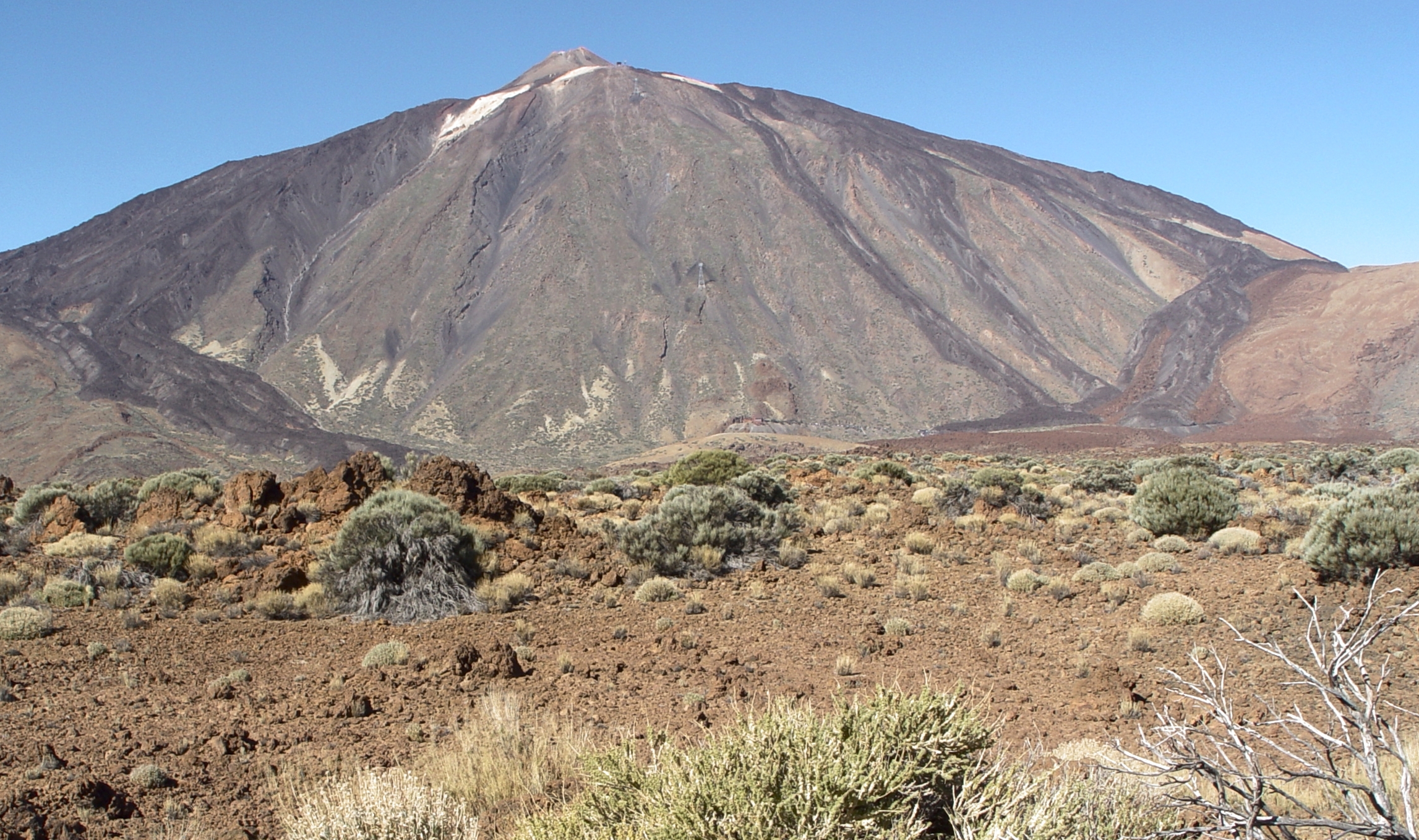
Quick answer: Ten outstanding places in the Canary Islands are the UNESCO historic town of San Cristóbal de La Laguna and Teide National Park on Tenerife; Timanfaya’s lava landscapes and the managed lava caves of Lanzarote; the Risco Caído sacred-mountain landscape and Maspalomas dunes on Gran Canaria; the Garajonay laurel forest of La Gomera; Caldera de Taburiente on La Palma; Corralejo dunes and nearby Lobos on Fuerteventura; and El Hierro’s small coastal settlements and biosphere-reserve landscapes.
The Canary Islands are a Spanish Atlantic archipelago west of North Africa, with several inhabited islands and distinct histories, ecosystems and transport networks. Their heritage cannot be summed up by volcanic scenery alone: the history of Indigenous Canarian societies, European colonisation, maritime commerce and contemporary island culture deserves serious attention. UNESCO recognises specific properties—including Teide, Garajonay, historic La Laguna and Risco Caído—rather than declaring every beach and volcanic cone to be World Heritage.
Planning involves real constraints. Mount Teide’s summit route has regulated permits, national parks can restrict walking and driving, dunes must be crossed only on authorised tracks and smaller islands need separate ferry or air travel. A scenic photograph does not demonstrate that a crater is accessible, a sea cave safe or a beach suitable for swimming. Choose two or three islands for a practical first journey and use the official protected-area guidance for every activity.
Mountain, heritage and reserve access
Climbing Mount Teide’s highest permitted summit route requires advance authorisation; other trails may have independent limits. Risco Caído’s archaeological areas and protected dune landscapes also require compliance with current local access instructions. This list does not promise entry to restricted areas.
eduKate · World heritage and learning
Find your reading route through the Canary Islands
Four UNESCO World Heritage properties, several national parks and distinct island communities.
ROUTE 1 · PLACES 1–3
Tenerife: historical town and high volcano
Learn about each location before moving on.
ROUTE 2 · PLACES 4–6
Lanzarote and Gran Canaria: volcanic art, history and dunes
Learn about each location before moving on.
ROUTE 3 · PLACES 7–10
La Gomera, La Palma, Fuerteventura and El Hierro
Learn about each location before moving on.
Choose your ten places
These destinations span several islands, and some include restricted natural or archaeological areas. Use the list to choose a manageable set rather than attempting all ten quickly.
| Place | Why choose it? |
|---|---|
| 1. San Cristóbal de La Laguna historic centre, Tenerife | Understand a UNESCO-inscribed town and its enduring urban plan. |
| 2. Teide National Park and Mount Teide, Tenerife | Read a UNESCO volcanic landscape with controlled mountain access. |
| 3. Timanfaya National Park, Lanzarote | Discover recent-looking lava forms through a regulated national park visit. |
| 4. Jameos del Agua and Cueva de los Verdes, Lanzarote | Compare a volcanic lava tube with island art and design. |
| 5. Risco Caído and the Sacred Mountains of Gran Canaria | Understand UNESCO-recognised Indigenous archaeology and a living mountain landscape. |
| 6. Maspalomas dunes and Charca de Maspalomas, Gran Canaria | Study moving sand, coastal habitat and tourism pressure. |
| 7. Garajonay National Park, La Gomera | Explore a UNESCO cloud forest of ancient laurel vegetation. |
| 8. Caldera de Taburiente National Park, La Palma | Read a vast volcanic mountain landscape shaped by erosion. |
| 9. Corralejo dunes and Isla de Lobos, Fuerteventura | Compare a protected dune coast with an offshore conservation island. |
| 10. El Hierro volcanic coast and the La Restinga marine setting | Discover the smaller island’s conservation identity and coastal communities. |
1. San Cristóbal de La Laguna historic centre, Tenerife
Why this place deserves time. La Laguna is a living historic city whose planned street network provides an important record of town-building and colonial history. UNESCO describes a historic upper and lower town, with the planned lower town influencing later settlements across the Atlantic. Churches, civic buildings, markets and homes share the historic centre, allowing a visitor to see both continuity and change. It should be read with care: the significance of architecture does not erase the histories of Indigenous Canarians and the effects of conquest.
What to notice. Walk the legal public streets, comparing squares, straight roads, religious buildings and courtyards. Some façades retain features associated with different centuries, while others have been repaired or adapted. Observe current cafés, shops and public transport instead of treating the heritage zone as an empty museum. Read interpretation carefully before assigning an age or historical function to a particular building.
The learning question. Draw a simplified grid of the historic centre and compare it with an unplanned settlement pattern. Why might a government choose wide streets and planned squares? UNESCO’s interpretation connects the plan to larger histories of Spanish expansion, but a balanced study should also ask whose land and lives were changed during colonisation. Distinguish documented changes from assumptions made from appearances.
Access and planning
Check individual museum and church hours, traffic arrangements and guided heritage access. The UNESCO designation covers a mapped historic property, not the whole city. Respect residents, places of worship and working public buildings. La Laguna is a thoughtful city outing rather than simply a brief stop en route to Teide.
2. Teide National Park and Mount Teide, Tenerife
Why this place deserves time. Teide National Park surrounds the Teide–Pico Viejo volcanic complex, including Spain’s highest peak. UNESCO recognises the landscape for geological significance and striking landforms. Visitors can appreciate volcanic terrain and scientific interpretation from authorised viewpoints without attempting a summit climb. The famous cable car and summit trail have separate weather, ticket and permit systems, so being able to reach the upper cable-car area does not automatically authorise an ascent to the summit.
What to notice. From a legal viewpoint, compare lava flows, rock forms, sparse vegetation and the immense volcanic cone. Differences in colour and texture hint at geological history but cannot be dated by a quick glance. Wind, temperature and altitude can be considerably more demanding than conditions at the coast. Do not leave paths to photograph fragile surfaces or walk toward restricted slopes.
The learning question. Construct a cross-section of a stratovolcano and its surrounding caldera-like landscape. Explain why an oceanic island can have high relief and why volcanologists need mapping and measurement to reconstruct successive events. Ask how restricting visitor numbers or trails can protect both people and the geological property that UNESCO recognises.
Access and planning
The Tenerife ON platform identifies the summit’s Telesforo Bravo trail (PNT-10) as requiring prior authorisation, and other high-mountain routes also have controlled access. Check the current permit system, cable-car operation, weather alerts and park restrictions. A viewpoint visit is not interchangeable with an advanced climb.
3. Timanfaya National Park, Lanzarote
Why this place deserves time. Timanfaya’s stark fields of lava and cinders provide a landscape unlike Tenerife’s high forest slopes or the sandy dunes of Gran Canaria. Spain’s official tourism portal describes the eruptions that shaped the region and the extraordinary landforms visible today. The park is protected and has controlled visitor arrangements that may include managed coach routes, designated interpretation points and separately authorised trails. It is not a general area for off-road driving or free wandering across lava.
What to notice. From authorised viewpoints, examine the forms of lava, cones and volcanic rock, noticing where fragile pioneer vegetation begins to appear. Different rock textures can suggest questions about cooling and movement, but exact dates require scientific sources. Avoid stepping onto sensitive new growth or collecting rock fragments. Even without a long hike, a carefully guided interpretation of the landform can be substantial.
The learning question. Compare Timanfaya with Teide. How do different eruption histories and ages produce visually different landscapes? Ask why land damaged or transformed by lava can eventually support organisms again. A historical source about the eruptions and a present geological interpretation are different forms of evidence that can be studied together.
Access and planning
Confirm current Timanfaya entry arrangements, road access, queues and guided-route requirements through the park or authorised operator. Do not leave permitted routes or attempt to enter closed lava tunnels. The landscape can be extremely exposed to sun and wind, so carry protection and allow time for the managed visitor sequence.
4. Jameos del Agua and Cueva de los Verdes, Lanzarote
Why this place deserves time. Lanzarote’s underground volcanic formations are particularly interesting where the lava tube system has been adapted for visitor interpretation. Jameos del Agua is associated with the work of César Manrique and the relationship between natural geology and designed cultural spaces, while Cueva de los Verdes provides a differently managed visit to the volcanic underground. They may be geographically related but are separate visitor experiences with their own tickets and tour conditions.
What to notice. In officially open areas, observe contrasts between rough volcanic surfaces, constructed paths, lighting and architectural intervention. Do not touch cave formations or enter closed passages. In a designed cultural space, ask how artistic choices guide what visitors notice while keeping the natural form visible. A cave’s shadow and uneven steps require real physical care rather than hurried photography.
The learning question. Compare the formation of a lava tube with the slowly eroded or dissolved cave structures found in different rock types. What physical evidence supports each explanation? Then ask how landscape art can be created without treating geology as disposable material. A visit can connect science, architecture and the island’s creative culture.
Access and planning
Check the official Jameos and Cueva de los Verdes booking pages for opening, guided-entry conditions, mobility restrictions and group capacity. Tickets may not be interchangeable. Do not assume a standard bus tour of Timanfaya includes both interiors, and do not venture into caves without permitted access.
5. Risco Caído and the Sacred Mountains of Gran Canaria
Why this place deserves time. The Risco Caído and Sacred Mountains property in the central hills of Gran Canaria is a UNESCO-listed cultural landscape with evidence of pre-Hispanic societies. Caves, granaries, cisterns, rock art and sacred areas express sophisticated adaptation to terrain and water, alongside cultural traditions of people with North African Amazigh origins. It should be approached with respect for archaeological evidence and living local communities rather than described as simply a spectacular natural crater or a collection of mysterious caves.
What to notice. From approved viewpoints and visitor centres, examine the relationship between steep ravines, terraces, settlements and routes. Archaeological caves and sacred spaces are not automatically open; some areas require controlled access to protect surfaces and context. Use credible interpretation to distinguish surviving structures from modern reconstruction or proposed explanations of astronomical meaning.
The learning question. Choose one feature such as a granary or water cistern and explain how it answered a practical environmental problem. A second question concerns the limits of historical interpretation: what do dated archaeological remains show, and which ideas about rituals are hypotheses requiring evidence? UNESCO’s documentation provides a useful basis for distinguishing findings from legends.
Access and planning
Check current official visitor centre or local authority access for the exact archaeological site and routes. Do not enter fragile caves, disturb rock art or take shortcuts across private mountain properties. Treat this as a focused mountain heritage day, not a short add-on to a beach afternoon.
6. Maspalomas dunes and Charca de Maspalomas, Gran Canaria
Why this place deserves time. Maspalomas combines a large coastal dune landscape with a lagoon-like pond, palm groves and busy resort areas. Spain’s official tourism guide describes protected dune habitat and birdwatching opportunities at the Charca. The contrast matters: a beach can support recreation, while neighbouring dunes and wetlands are vulnerable ecosystems that require visitor boundaries. The dunes should not be imagined as a blank playground where every ridge is public footpath.
What to notice. From established public viewpoints or marked routes, observe how wind shapes sand forms and how plants grow in sheltered sections. Use binoculars for birds around the pond rather than entering sensitive edges. Compare the ecological reserve with neighbouring hotels and walkways, noting how visitor numbers affect maintenance and protection. Do not assume every part of the shore has the same safe swimming conditions.
The learning question. Draw a simple dune cross-section and show how wind may move sand, while vegetation can affect stability. Ask why a dune field and wetland can be protected within a highly developed tourism zone. Compare the Maspalomas sand landscape with Corralejo on Fuerteventura to investigate similarities and site-specific differences without relying on one photograph.
Access and planning
Follow the marked trails and protected-area signs. Check current closures, parking and beach guidance, and do not enter prohibited dunes or Charca margins. Sun, hot sand, wind and ocean currents can make the day more demanding than it appears. Families may choose a short legal nature walk rather than crossing exposed dune areas.
7. Garajonay National Park, La Gomera
Why this place deserves time. Garajonay on La Gomera is a UNESCO World Heritage natural property celebrated for its exceptionally preserved laurel forest. Its misty canopy, springs and endemic species contrast with the exposed volcanic landscapes of Lanzarote and Tenerife. This forest is scientifically important because it preserves a type of vegetation once much more widespread in parts of Europe and North Africa. The site is a living ecological system with restrictions, not simply a mystical green background for photographs.
What to notice. Along an open signed trail, look for dense canopy, ferns, moss and changes in humidity. Cloud and rain can transform the atmosphere rapidly, and paths may be slick or temporarily closed. Observe birds quietly without claiming a rare species unless identified accurately. Stay on routes to avoid damaging delicate understory plants and soil.
The learning question. Compare Garajonay with Madeira’s Laurisilva. Both have UNESCO-recognised laurel-forest heritage, but they are distinct protected properties with their own management and endemic species. Ask how persistent moisture, altitude and exposure support this vegetation. What kinds of long-term observations would be needed to understand threats from invasive species or fire?
Access and planning
La Gomera usually requires a separate ferry or flight arrangement. Check the park’s official paths, seasonal restrictions, fire warnings and weather before hiking. Do not leave trails in mist or assume the forest is suitable for every mobility level. A visitor centre or short nature route can still provide meaningful learning.
8. Caldera de Taburiente National Park, La Palma
Why this place deserves time. Caldera de Taburiente on La Palma is one of the island’s great natural features, with steep walls, ridges and deep ravines. The national park provides a different geological lesson from Timanfaya’s relatively young lava or Teide’s dominant summit cone. Its impressive landform invites visitors to ask how volcanic processes and erosion work together over long timescales. The park protects habitats and watercourses, so even a striking viewpoint must be chosen with attention to present access and weather.
What to notice. From authorised lookout points, compare the height of enclosing walls with the valley floor and identify the role of ravines. Some hiking routes can be extremely demanding, with river crossings or long descents. Fog, rainfall and falling rock hazards can make an apparently simple trail impractical. Observe without crossing protected barriers for a closer photo.
The learning question. Use a cross-section of a deep volcanic basin to distinguish a simple volcanic crater from a complex landscape that has also been shaped by erosion. Compare the photographic appearance with an official geological interpretation. How do drainage networks change slopes, and why can a park restrict access during heavy rain even when the sun shines at the entrance?
Access and planning
Verify the national park’s current routes, permits where applicable, ranger advice and transport logistics. Do not improvise a descent based on a map alone. La Palma is a separate island commitment and should be given enough time to account for changing mountain conditions and trail closures.
9. Corralejo dunes and Isla de Lobos, Fuerteventura
Why this place deserves time. Corralejo Natural Park on Fuerteventura features extensive dunes and a coastline rich in sand-related ecological questions. Spain’s official tourism portal identifies protected native species and designated trails. Just offshore, Isla de Lobos forms another nature reserve that can be visited under specific authorisation and boat arrangements. These are related landscapes but not one open-access playground; the sea crossing and island permit need separate planning.
What to notice. On approved dune routes, observe the effect of wind on sand and how vegetation survives in exposed settings. Compare the view across to Lobos and the changing colour of surrounding water. Do not disturb bird habitats, plants or fragile sandy surfaces. At the island, follow designated trails and never land outside authorised points.
The learning question. Compare the movement of sand at Corralejo with dunes at Maspalomas, then ask what local conditions make their shapes different. Discuss why a small island reserve might control daily visitors and restrict areas for wildlife. Clear water and visible shore proximity do not demonstrate safe swimming between islands.
Access and planning
Spain’s official tourism service instructs visitors to follow the Corralejo designated trails. Verify Lobos visitor authorisation, boat schedules and limits through local official services before departure. Carry water and sun protection, and never attempt an unregulated crossing or off-route dune walk.
10. El Hierro volcanic coast and the La Restinga marine setting
Why this place deserves time. El Hierro offers an important alternative to the busiest Canary Islands, with volcanic coasts, upland landscapes and settlements that reveal how a small island community manages resources. The island is recognised as a UNESCO biosphere reserve, a designation distinct from World Heritage inscription. La Restinga is associated with marine conservation and diving, but the wider island’s value lies in combining ecology, culture, energy systems and a slower visitor rhythm.
What to notice. From legal coastal viewpoints, observe steep lava cliffs, pools and the interface of harbour infrastructure with the open Atlantic. Underwater environments should be explored only with reputable local operators using suitable qualifications. Notice that a biosphere reserve includes people and sustainable livelihoods as well as wildlife; an island’s environmental story is not simply a list of spectacular rock formations.
The learning question. Compare the role of a biosphere reserve with the UNESCO World Heritage properties of Teide, Garajonay and Risco Caído. Why are their recognition purposes and management arrangements different? Consider how energy, water, food and transport decisions become especially visible on a smaller island with limited connections.
Access and planning
El Hierro requires its own ferry or flight plans. Check nature reserve protections, approved dive operator standards, sea conditions and local roads before booking. Natural pools and wave-exposed rock may be unsafe depending on swell; use designated sites only when permitted and appropriately supervised.
Plan a thoughtful Canary Islands journey
Choose a few islands, not ten across the sea. Tenerife and Gran Canaria have very different attractions, while Lanzarote, La Gomera, La Palma, Fuerteventura and El Hierro need independent connections. La Graciosa is another inhabited island worth considering, but a ten-place shortlist cannot represent every location. Check ferries, airports and your itinerary before making hotel bookings.
Understand the UNESCO designations precisely. Teide and Garajonay are natural World Heritage properties; La Laguna and Risco Caído are cultural World Heritage properties. El Hierro has UNESCO biosphere reserve status under a different programme. Timanfaya is a national park, not automatically an additional World Heritage property.
Use official permits and track conditions. Teide’s summit route requires advance authorisation, and controlled routes can have separate access requirements. Timanfaya’s visitor routes are managed, while protected dunes and caves may have closed or limited areas. Never assume an Instagram path is lawful.
Prepare for mountain and coastal weather. Altitude at Teide can cause cold or wind even when beach towns are warm; cloud and rain affect Garajonay and La Palma trails. At sea, swell and currents can make a lovely beach unsafe. Local authority and operator instructions determine access.
Respect Indigenous heritage and living culture. The Canary Islands have historical layers stretching from pre-Hispanic societies to contemporary Spanish and island communities. Archaeological caves and sacred sites require source-based interpretation and protection; do not touch art, move artefacts or invent meanings.
Support local conservation through good behaviour. Stay on permitted trails, avoid collecting plants or rock, respect bird habitat and never cross dune restoration barriers. A shorter guided experience is often more informative than a dangerous unpermitted route.
Frequently asked questions
Are the Canary Islands one island?
No. They form a Spanish archipelago with several inhabited islands and separate transport networks. Choosing two or three for one trip is more realistic than attempting every island.
Can anyone climb to Teide’s summit without a permit?
No. The summit’s Telesforo Bravo trail requires prior authorisation, and some other high-altitude routes are regulated. Check Tenerife ON and current weather and trail notices.
Are all Canary Islands national parks UNESCO World Heritage Sites?
No. Teide and Garajonay are World Heritage properties, while other parks such as Timanfaya and Caldera de Taburiente are separately protected national parks.
What is Risco Caído famous for?
It is part of a UNESCO cultural landscape preserving evidence of Indigenous Canarian society, including caves, granaries, cisterns and ritual spaces in the mountains of Gran Canaria.
Can I walk anywhere through Maspalomas or Corralejo dunes?
No. Both are protected environments with designated routes. Follow local restrictions to avoid damaging dune vegetation and wildlife habitats.
Is La Graciosa worth including?
Yes, especially for an island-focused itinerary in the eastern Canaries, but it requires a separate boat journey and respectful access to its sensitive landscape. It is an alternative to part of this top-ten selection.
Build understanding through evidence
The Canary Islands make it possible to compare historical town planning, archaeological evidence and several volcanic ecosystems. La Laguna offers an urban-history question; Risco Caído helps investigate Indigenous land use; Teide and Timanfaya invite geological comparisons; Garajonay shows how moisture sustains laurel forest; dune reserves reveal fragile coastal dynamics. Treat each claim according to the type of evidence it needs, and do not mistake a tourism designation for an access permit.
A family route-planning exercise can compare a Tenerife city, Lanzarote volcano and La Gomera forest on a map, then determine which legs need flight or ferry transfers. State every assumption and use reliable schedules instead of guesses. This habit of clear mathematical reasoning is also central to eduKate’s Secondary 1 Mathematics Tutor Clementi | Small Groups Tutorials.
Continue learning about the Canary Islands
Top 10 Things to Do When Visiting and Touring Canary Islands · Top 10 Things to Learn When Visiting and Touring Canary Islands · World Country Directory
Sources and current information
Sources reviewed on 19 October 2026 (Singapore time). World Heritage designations are documented by UNESCO; trail permits, boat operation, site admission and safe weather are separate conditions that require current checks. Do not use an old itinerary as proof of legal access.
Featured photograph: Mount Teide, Tenerife, photographed by Cb22hh on 14 December 2011, CC BY-SA 3.0, via Wikimedia Commons. The unchanged archival photo does not establish current summit access.

- UNESCO World Heritage — Teide National Park
- UNESCO World Heritage — San Cristóbal de La Laguna
- UNESCO World Heritage — Garajonay National Park
- UNESCO World Heritage — Risco Caído and Sacred Mountains
- Tenerife ON — Telesforo Bravo summit trail and permission
- Spain Tourism — Timanfaya National Park
- Spain Tourism — Corralejo Natural Park and designated trails
- Spain Tourism — Maspalomas natural dunes
- Spain Tourism — Maspalomas and its protected lagoon
- National Park Reservation System — Tenerife access