
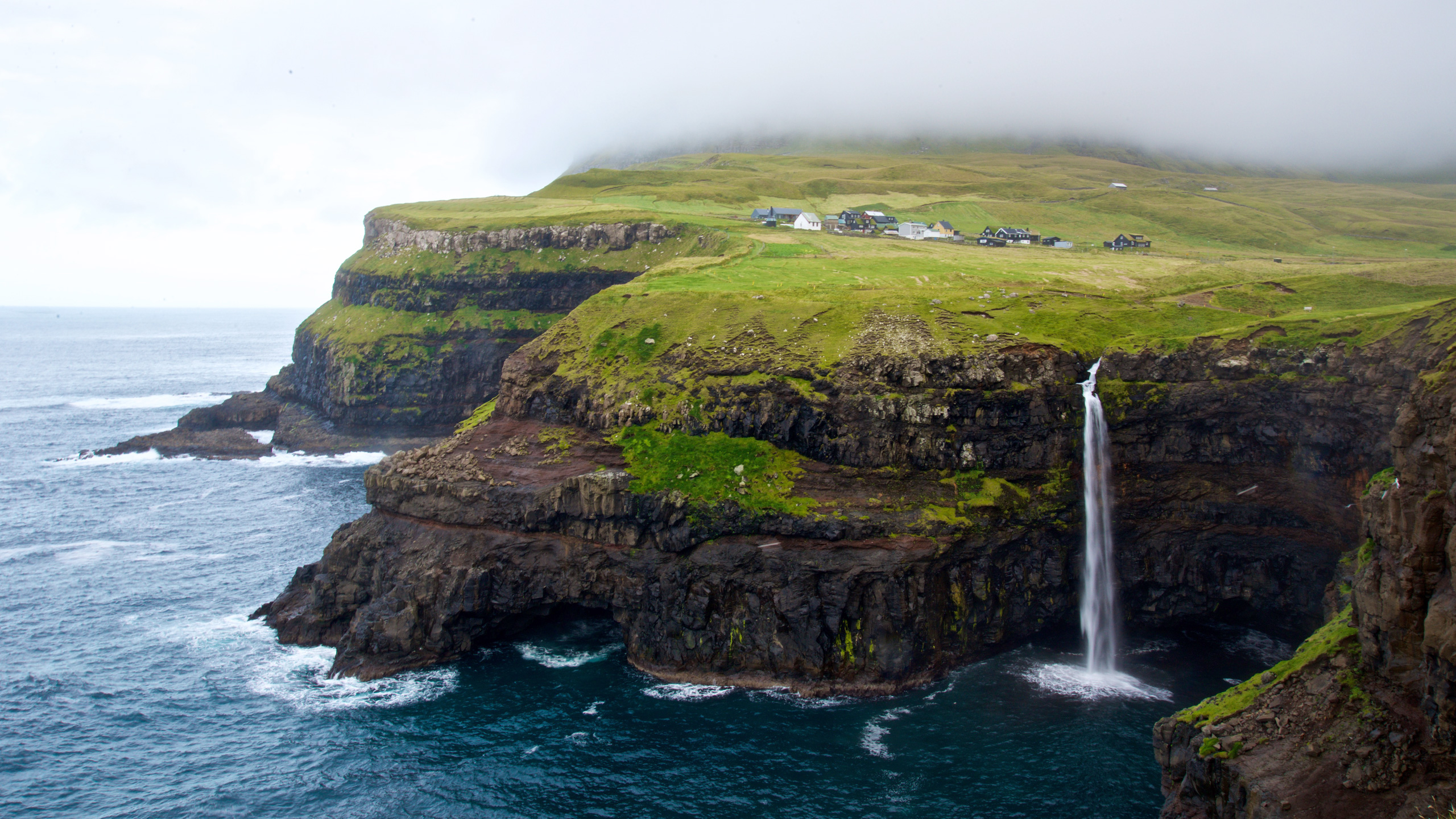
The Faroe Islands are known for dramatic cliffs, waterfalls and small villages tucked between mountains and the North Atlantic. Yet their most rewarding places are not simply natural backdrops. They tell stories about seafaring, land use, farming, language, local traditions and the decisions island communities make when weather, transport and terrain have the final say. A balanced visit pairs a few famous viewpoints with time in places where people actually live and work.
This list spans several islands, from Streymoy and Vágar to Eysturoy, Kalsoy and Mykines. The ten places are not a single circular walk, nor is every celebrated viewpoint freely accessible. Some routes cross private land, require a guide or fee, or are closed for conservation or safety. Ferries, tunnels and boat excursions operate under changing conditions. Choose a practical base, allow for weather contingencies and prioritise the places you can visit respectfully.
The guide is organised around ten contrasting experiences: historic Tórshavn, a medieval ecclesiastical site, waterfalls, cliff landscapes, villages, boat-based scenery and seabird habitats. The most useful question is not whether you managed to photograph all ten, but what each place helped you understand. Use the official Visit Faroe Islands information alongside up-to-date notices from relevant local operators, and never treat a social-media hiking route as proof of legal or safe access.
eduKate · World heritage and learning
Find your reading route through Faroe Islands
Explore capital heritage, village landscapes, coastal cliffs, ferries and responsible birdwatching.
ROUTE 1 · PLACES 1–3
Tórshavn, Kirkjubøur and Vágar viewpoints
Read three or four places, then continue.
ROUTE 2 · PLACES 4–6
Village landscapes on Streymoy and Eysturoy
Read three or four places, then continue.
Travel planning
Weather, permitted paths and ferries shape the journey.
Official sources
Check current guidance and supporting information.
Choose your places
Some places below are villages, some are coastal viewpoints and some require organised transport or permitted hiking. Use the index to decide what fits your trip rather than treating it as a ten-stop day out.
| Place | Why choose it? |
|---|---|
| 1. Tórshavn and the Tinganes peninsula | See how political history and modern island life share the harbour. |
| 2. Kirkjubøur and the medieval ecclesiastical landscape | Understand church history in a working coastal village. |
| 3. Gásadalur and Múlafossur waterfall | Observe a waterfall framed by cliffs and the Atlantic. |
| 4. Sørvágsvatn and the Trælanípa cliffs | Study a celebrated lake-and-sea illusion from a permitted route. |
| 5. Saksun village and its valley | Understand rural land use in a mountain-framed fjord valley. |
| 6. Tjørnuvík and the sea stacks | Read surf, geology and settlement at a northern coastal village. |
| 7. Gjógv and its natural harbour gorge | See how a sheltered landing place shaped a village. |
| 8. Vestmanna bird cliffs by organised boat | Observe sea-cliff ecology from the water when conditions permit. |
| 9. Kalsoy, Mikladalur and the island’s northern landscapes | Explore a ferry-connected island with dramatic ridges and village heritage. |
| 10. Mykines village and the seabird coast | Appreciate a fragile island ecosystem without treating nests as attractions. |
1. Tórshavn and the Tinganes peninsula
Why this place deserves time. Tórshavn is one of the best starting points because its old harbour area connects the maritime past with contemporary Faroese government, work and culture. Tinganes is associated with the old assembly tradition, and its red buildings and turf roofs sit close to ordinary commercial streets. The appeal is not a staged reconstruction: it is the chance to understand how a small Atlantic capital has developed around a useful and sheltered coastal position. Visiting a museum or local cultural venue adds depth to a walk through the old streets.
What to notice. Compare the compact lanes near Tinganes with newer parts of the capital. Notice roof materials, the relationship between buildings and the water, and the way small boats, public functions and shops coexist around the harbour. Read interpretation rather than guessing the age or use of a building from its appearance. Government buildings may be working premises rather than general visitor spaces.
What to learn here. Use an old-map-versus-current-map comparison to ask why the town formed around its harbour and how it expanded. This is a practical lesson in settlement geography and political continuity. Ask which features are historical structures and which are newer, heritage-sensitive adaptations. The changing city matters as much as preserved architectural detail.
Access and planning
Explore on public streets and respect marked private areas and government building boundaries. Check official opening and event information for museums or exhibitions. Tórshavn is a useful practical base for exploring connected islands, but delays and longer transfers can still affect a day plan. Strong wind and wet pavement can make even a city walk feel exposed.
2. Kirkjubøur and the medieval ecclesiastical landscape
Why this place deserves time. Kirkjubøur offers a different Faroese story from urban Tórshavn. Its medieval church remains, the still-used Saint Olav’s Church and historic farm setting make it an important place for understanding religious institutions and settlement through time. The surviving buildings and ruins should be considered together with a present-day rural community, rather than treated as a group of abandoned monuments. For history-minded visitors it rewards careful reading and restraint.
What to notice. Compare the architectural language of the cathedral ruins with the smaller church and neighbouring farm. Observe the exposed coastal position and ask how wind, sea air and building materials affect preservation. A heritage site needs conservation precisely because it remains subject to physical change. Respect any barriers and signs that separate publicly accessible ground from private farm areas.
What to learn here. The guiding question is what surviving architecture can establish about authority, religion and daily work, and what written records would be needed to complete the story. Make a simple chronology distinguishing the medieval period, later use and present-day care. Avoid projecting today’s village life unchanged into the past.
Access and planning
Confirm which buildings or spaces are open to visitors before travelling. Part of the setting is a working farm and home, so access is not automatic. Take weather-resistant clothing for an exposed coastal visit and never climb unstable or protected masonry. Combine Kirkjubøur with a sensible Tórshavn day instead of planning it as a brief roadside photo stop.
3. Gásadalur and Múlafossur waterfall
Why this place deserves time. Múlafossur near Gásadalur is famous for a waterfall flowing over cliffs towards the sea, with the village and surrounding mountains forming part of the wider scene. The place is useful for understanding how a remarkable view can coexist with a real small settlement. Its beauty is not a licence to cross fences, disturb residents or creep closer to the cliff edge. The photographed perspective is only one aspect of the region’s topography and changing access history.
What to notice. From a suitable signed or established vantage point, identify the waterfall’s course, the cliff face and the wave conditions below. In strong winds, spray can shift direction abruptly. Compare the village’s position with the route approaching it and consider what terrain meant for transport before easier road access. The result is a richer story than ‘water falling into the ocean’.
What to learn here. Try a simple physical geography sketch showing the stream, cliff, coast and settlement. Mark which part of the drawing is directly visible and which is inferred from the map. Then consider how climate and weather influence what visitors actually see; a photograph taken on one day is not a guarantee of identical conditions.
Access and planning
Consult current tourist and local safety guidance for the lawful viewing area. Remain well back from cliff edges, especially in wind or rain, and do not enter farm fields or private gardens. The popular viewpoint can be crowded at times; if conditions are poor, use a safe village visit or other Vágar sights as an alternative.
4. Sørvágsvatn and the Trælanípa cliffs
Why this place deserves time. Sørvágsvatn, also known as Leitisvatn, appears in many photographs as a lake suspended dramatically above the ocean. The effect depends on the viewpoint and the relationship between lake, cliff and sea. It is an excellent example of why perspective matters: the popular photograph highlights one striking visual alignment, but does not describe the whole lake or the climb needed to reach a viewpoint. The walking area may be subject to access controls, a fee or guiding conditions.
What to notice. If you take a permitted, safe route, study how the shoreline changes as you move and how the optical impression depends on position. Waves and wind on the cliff side can be far stronger than conditions close to the road. Do not approach precipitous edges for a photograph; binoculars or a safer viewpoint may reveal more detail.
What to learn here. This is an ideal place for explaining perspective in photographs. Compare the location on a map with a viewpoint photograph and ask what each represents accurately. A careful explanation distinguishes elevation, distance and the impression created by a camera angle, rather than treating the picture as a puzzle with a sensational solution.
Access and planning
Check the official local guidance for walking access, any mandatory route fee or guide, trail hours and closures before leaving. Stay entirely on permitted paths and away from exposed edges. In strong wind, fog or rain, abandon the walk: visibility and footing are more important than reaching the Instagram vantage point.
5. Saksun village and its valley
Why this place deserves time. Saksun’s turf-roofed buildings, small church and steep valley setting have made it a favourite landscape subject. Yet the area is also agricultural land with private property and residents. To visit thoughtfully is to recognise the difference between a place worth seeing and a field that is yours to wander through. The surrounding landscape reveals the relationship between a high-sided valley, farming and the historic importance of coastal access.
What to notice. From permitted public ground, observe the valley’s steep sides and the way farm buildings sit on more usable terrain. The lagoon and tidal sands may look easy to explore from a distance but have their own hazards. Be especially careful not to mistake unmarked agricultural tracks for public trails, and resist any impulse to photograph people or homes without permission.
What to learn here. Ask why valleys concentrate settlement where their terrain is usable, and how the landscape might constrain the number of roads or safe walking options. Sketch the relative positions of water, building clusters, fields and mountains. A geography exercise becomes an etiquette lesson when it records boundaries and access as part of the real landscape.
Access and planning
Check whether the exact route you plan to walk is authorised and whether fees or landowner conditions apply. Do not attempt a shortcut through fields or across tidal ground. Weather, wet grass and steep slopes can turn a short excursion into a hazard. Treat the village as a lived place, not an open-air film set.
6. Tjørnuvík and the sea stacks
Why this place deserves time. Tjørnuvík is a small settlement facing a striking coastal view associated with the offshore rock stacks Risin and Kellingin. The village’s sandy shoreline, enclosing hills and exposed sea make it a memorable place to see how geology and weather contribute to local identity. Unlike a single observation platform, a village offers many reasons to slow down: coastline, building patterns, changing light and the difficulty of travelling through steep island terrain.
What to notice. Compare the beach and coastal cliffs without approaching unstable rocks or hazardous waves. Look towards the stacks and consider how relentless erosion acts on different rock forms. Notice the village’s position in the landscape and how the steep approach shapes its relationship to other communities. The legends associated with the sea stacks can be appreciated as cultural narrative without confusing them with geological explanation.
What to learn here. Make two short accounts of the same landscape: one describing observable rock and sea processes and another explaining a locally recorded story or tradition. They answer different kinds of questions. The exercise shows why cultural heritage and physical geography can enrich one another without needing to be presented as competing explanations.
Access and planning
The road to Tjørnuvík can be narrow and requires careful driving. Park only where allowed and keep access clear for residents. Coastal waves and beach conditions vary: do not assume swimming is appropriate. Check weather and local guidance, and favour a quiet visit instead of pressing on when the conditions make the approach unsafe.
7. Gjógv and its natural harbour gorge
Why this place deserves time. Gjógv is named for its distinctive narrow gorge, which forms a dramatic natural harbour-like passage between dark cliffs. The setting gives a vivid explanation of why a community might use a seemingly unlikely coastal site. Alongside the gorge are the village’s houses, pathways and mountain slopes. This is a place to study practical relationships between shore, navigation and settlement rather than only the striking shape of the land.
What to notice. Observe the gorge from established safe positions and consider how boat access, tides and rough water might affect its usefulness. The water can be hazardous even when the village is calm; steep rock and wet surfaces should never be treated as casual viewing steps. Look for evidence of the village’s relationship with the water without intruding into working areas or private property.
What to learn here. Draw a cross-section of a narrow gorge and list both its benefits and limitations as a landing site. Contrast that with a conventional open beach or broad harbour. The comparison is useful because it avoids the assumption that only one landscape type could support coastal life.
Access and planning
Use marked viewpoints and pathways, and stay away from cliff edges and slippery rocks. Follow signs on private land and any footpath fees or seasonal restrictions for hikes beyond the village. Fog and high winds can reduce visibility and make additional walking unwise. Village facilities and parking may have limited capacity.
8. Vestmanna bird cliffs by organised boat
Why this place deserves time. The towering coastal cliffs near Vestmanna have long been associated with boat excursions that show caves, narrow inlets and seabird habitats from the sea. The attraction is different from a clifftop hike: the boat offers a perspective on geology and nesting places that may be impossible to appreciate from land. Wildlife behaviour and safe navigation should determine how close a vessel approaches, not passengers’ desire for a dramatic picture.
What to notice. From the boat, compare layered rock faces, cave openings and ledges that may serve as nesting sites. Bird activity changes seasonally, and the absence of puffins on a particular excursion does not mean the cliffs are unimportant. Notice how sunlight and sea conditions alter the visibility of textures. The guide’s local knowledge can help distinguish species and interpret maritime conditions.
What to learn here. Ask how cliff ledges, food availability and breeding seasons affect seabirds, and why sensitive nesting areas benefit from careful boating practice. A field notebook that records what was actually seen is better evidence than an advertising image. The sea cliffs also provide a way to discuss erosion and the physical forces shaping high coastlines.
Access and planning
Book with a reputable local operator that follows wildlife protections and assesses swell and wind. Excursions can be changed or cancelled in adverse conditions, and rough water may not suit everyone. Do not arrange unsupervised access to cliff bases or caves by private craft. Read operator information about accessibility, lifejackets and refunds.
9. Kalsoy, Mikladalur and the island’s northern landscapes
Why this place deserves time. Kalsoy is celebrated for steep mountain slopes, narrow settlements and the northern lighthouse landscape. Mikladalur offers cultural storytelling, including the well-known Seal Woman statue, that can provide a gentler alternative to difficult hikes. The island is an excellent case study in the connection between a memorable destination and the limited transport that serves residents. A ferry is not simply a tourist shuttle: it is part of local life.
What to notice. Notice the mountain-and-fjord geometry from accessible areas and the way the road links small places across difficult terrain. In Mikladalur, take time to read the local story associated with the statue instead of treating it as a prop. The northern ridge views can be spectacular, but a thin path near steep slopes requires judgement, proper permissions and suitable conditions.
What to learn here. Compare the times and constraints of a ferry trip with a drive through a tunnel on another island. Explain why a trip planner needs crossing capacity and schedules, not just kilometres. Connect a locally told legend with the physical setting in which it is shared. The island gives geography and cultural learning a natural meeting point.
Access and planning
Check ferry timetables, reservation or vehicle-space requirements, local bus links and the conditions of any proposed trail. Do not assume the Kallur lighthouse approach is open, free or safe; use current local advice and guidance. In wind, fog or poor footing, choose permitted village visits instead of exposed ridge walking.
10. Mykines village and the seabird coast
Why this place deserves time. Mykines is associated with seabirds and a rugged western edge of the archipelago. Its small settlement, coast and breeding habitats make it a compelling place to understand why conservation changes visitor access. Puffins and other seabirds should be observed from an appropriate distance using permitted paths and local guidance. A successful visit can be a quiet lesson in ecological restraint even if it does not include a famous lighthouse photograph.
What to notice. Look for nesting habitat patterns from lawful viewpoints, watching bird movements rather than pursuing individual birds for close portraits. Vegetated slopes can conceal burrows and delicate nest areas. Stay out of closed sections and away from erosion-prone cliff edges. The village itself is a working community that deserves the same respect as more accessible settlements.
What to learn here. Ask why a species returns to specific nesting areas, what human footfall does to burrows or vegetation and why restrictions can vary by season. Treat local conservation notices as part of the story of the place rather than an inconvenience. A naturalist’s observation should identify its limitations, including weather and season.
Access and planning
Mykines access depends on transport schedules, weather, conservation rules and permitted hiking conditions. Official visitor guidance has highlighted a closure affecting the lighthouse path after a landslide: do not plan or promote that trail without fresh authoritative confirmation of legal and safe access. Check island-specific rules, fees and guided-access requirements before departure; never bypass closures.
Plan a thoughtful Faroe Islands visit
Build the trip around transport realities. Tórshavn is a practical base for connected islands, while Kalsoy and Mykines require special attention to ferry or boat arrangements. Road tunnels can shorten some journeys, but they do not remove the need to plan for local schedules and limited parking. Give the main island group a realistic daily focus rather than attempting every viewpoint before dinner.
Check land access, fees and closures each time. Many of the most photographed routes cross privately owned land. Permission, access charges and compulsory guides can apply or change. Use official information and current notices, not a route shared without a date. Do not cross barriers, enter fields or assume a visible trail is a public right of way.
Treat cliff weather seriously. Wind, fog, wet grass and exposed drops can make paths dangerous even when the route appears short. Start by checking weather and your own abilities; turn around early if visibility or footing deteriorates. A safe museum, village or harbour alternative is a successful day, not a failed excursion.
Respect birdlife and village residents. Stay well away from nesting areas, do not block access to homes or farms, and ask before photographing people. Summer nesting seasons bring special sensitivities, and an island’s small population must be able to go about daily work. Choose licensed local guides and follow their conservation instructions.
Allow time for weather cancellations. A sea-cliff cruise or Mykines trip can be cancelled because conditions are unsuitable. Read refund terms and have a second activity within easy reach. Do not compensate for a cancelled boat by attempting an unsupervised cliff route.
Frequently asked questions
Is the Mykines lighthouse hike open?
Do not assume it is. Official visitor guidance has reported a landslide-related closure of the lighthouse route. Check the current island-specific rules directly, and never enter closed trails. Mykines village and permitted birdwatching are distinct from access to that lighthouse path.
Are all Faroe Islands hikes free?
No. Some routes may require an access fee, a guide, prior permission or have restrictions. Terms can change, and the existence of a footpath does not mean free public access. Check the particular route before setting out.
Could all ten places fit into two days?
No sensible plan should guarantee ten across several islands in two days. Sea crossings, fog, route conditions and time needed to experience places properly argue for a smaller shortlist and alternatives.
Can I visit bird cliffs without disturbing wildlife?
Yes, where lawful tours or viewing areas are available, by following local wildlife guidance and remaining at a distance. Avoid nests, burrows, drone disturbances and any closed breeding areas.
Build understanding through evidence
To study the Faroes thoughtfully, compare the explanation given by a photograph with what a field visit can actually establish. A single waterfall photograph does not show access rules. A map may show a short island distance without ferry schedules. An impressive bird image may conceal a sensitive nesting area. Good travel decisions require combining visual evidence, local ecological understanding, weather forecasts and community rules.
After your visit, choose one place and draw a simple annotated route map. Label the details you directly observed, the local explanations you were given and the claims that need checking against reliable sources. Explaining the difference between observation and interpretation strengthens school reasoning skills; see eduKate’s Secondary 1 Mathematics Tutor Clementi | Small Groups Tutorials for a related educational approach.
Continue learning about the Faroe Islands
Top 10 Things to Do When Visiting and Touring Faroe Islands · Top 10 Things to Learn When Visiting and Touring Faroe Islands · Top 10 Places to Visit When Touring Denmark · World Country Directory
Sources and current information
Sources reviewed on 17 October 2026 (Singapore time). Faroe Islands hiking access, landowner permissions, fees, ferry capacity, boat departures and closures can change. Official descriptions do not guarantee access on your dates. Confirm every path and crossing directly before travel, and respect safety notices and privately owned land.
- Visit Faroe Islands — hiking and walking
- Visit Faroe Islands — guide to safe hiking
- Visit Faroe Islands — hiking fees and access
- Visit Faroe Islands — Gásadalur
- Visit Faroe Islands — Múlafossur waterfall
- Visit Faroe Islands — Langasandur to Saksun trail
- Visit Faroe Islands — Vágar and Mykines guide
- Visit Faroe Islands — public transport
- Visit Faroe Islands — regional cycling and Kirkjubøur