
18 October 2026 — Guam is not currently a sightseeing destination
Guam Homeland Security’s 12:45 p.m. release says Guam remains at Condition of Readiness 1. People are directed to remain indoors in substantial shelter until an official COR4 announcement, stay off roads and avoid all shorelines and water. Super Typhoon Champi has produced dangerous winds and flooding. This article is a future-travel and cultural-learning reference only, not an instruction to visit any attraction now. Wait for Guam’s official all-clear, then each site’s own damage inspection and reopening before attempting travel. Read the official live emergency release · Latest government updates.
Guam is the largest island in the Mariana archipelago, a U.S. territory in the western Pacific with a distinctive CHamoru cultural identity. Its coastlines, historical sites, living villages and nature reserves are often described in pleasant holiday guides. However, those descriptions cannot substitute for present safety information, especially in the immediate aftermath of Super Typhoon Champi on 18 October 2026.
The ten places below are included for their historical, environmental and educational importance. Some are National Park Service units with wartime memorials, others are reef habitats or cultural sites that require separate permissions. An old opening schedule or beach photograph is not evidence that a location remains safe after destructive winds. Until emergency authorities lift restrictions and local operators announce reopening, read these entries from a safe location.
The best future tour will balance cultural history, island communities, ecology and an understanding of why Guam is more than the resort shoreline at Tumon. CHamoru heritage predates Spanish and American rule, and the history of the Pacific War must be told with attention to the experiences of the people of Guam. This selection therefore includes public culture, places of memory and sensitive natural environments.
Find a future Guam reading route
See all ten places · History and culture · War and remembrance · Coastal heritage · Protected nature · Reopening checklist
There are no active touring itineraries during COR1. All route suggestions below apply only after official clearance and individual site checks.


Top ten Guam places at a glance
These locations illustrate Guam’s heritage and landscapes, not places to visit immediately. The table’s access column identifies which operator or public authority must provide new information when emergency conditions improve.
| Place | Why it matters | What must be checked |
|---|---|---|
| 1. Hagåtña’s Plaza de España and Guam Museum | Capital’s layered civic history and cultural collections | Reopenings and public-site inspections after Typhoon Champi |
| 2. Senator Angel Leon Guerrero Santos Latte Stone Memorial Park | Historic latte stones and CHamoru cultural identity | Storm-damaged trees or pathways; cultural respect |
| 3. Asan Bay Overlook and Memorial Wall | World War II remembrance and view of the landing beaches | Official post-storm site safety; memorial etiquette |
| 4. T. Stell Newman Visitor Center and War in the Pacific National Historical Park | Museum context for occupation and the 1944 battle | Ranger hours and emergency closures |
| 5. Puntan Dos Amantes (Two Lovers Point) | Cliff-top panorama and CHamoru cultural legend | Operator closed 16 October for Typhoon Champi |
| 6. Tumon Bay and Ypao Beach Park | Marine habitats alongside a busy tourist district | All coastal entry prohibited during the current storm emergency |
| 7. Ritidian Point and Guam National Wildlife Refuge | Protected limestone forest, CHamoru heritage and beach landscape | Refuge gate shut in hazardous conditions; no walk-in access |
| 8. Gef Pa’go CHamoru Cultural Village, Inalåhan | Local crafts, language and living heritage | Demonstration schedule and post-storm community priorities |
| 9. Fort Nuestra Señora de la Soledåd, Humåtak (Umatac) | Spanish-era Pacific navigation and harbour defence | Southern storm-damage inspection and coastal edges |
| 10. Inalåhan Natural Pools and southern village landscape | Coastal geology and community recreation with strong safety limits | No swimming or coastal access during ongoing emergency |
1. Hagåtña’s Plaza de España and Guam Museum
What makes this place important: Hagåtña provides a better introduction to Guam than an exclusively beach-based itinerary because it is the island’s capital and has long been a setting for changing forms of government, commerce and everyday CHamoru life. Plaza de España contains surviving elements associated with Spanish colonial administration; the Guam Museum nearby offers interpretation of island history and culture. This pairing lets visitors compare what remains in the streets with objects, maps and accounts curated in a modern public institution. Both belong to an active city, not a staged historic village.
The historical or environmental context: The Guam Visitors Bureau describes the former governor’s complex at the plaza and highlights three surviving architectural elements: the three-arch gate, the azotea and the Chocolate House. Those remnants should not be mistaken for a complete unchanged palace. Guam’s history predates Spanish arrival by millennia, and the later American and Japanese periods also affected the capital. The CHamoru people have continually shaped the island’s language, cultural practices and institutions. A careful visit asks whose history is represented by each object or building and what evidence the interpretation uses, instead of assuming that a colonial façade explains the entire island.
Access and safety after the storm: Travel to Hagåtña only after the Government of Guam declares it safe to move about following Typhoon Champi and after municipal facilities confirm conditions. The latest emergency bulletin reviewed on 18 October ordered residents to stay indoors, so there is no immediate walking itinerary. When authorities lift restrictions, check the museum’s current hours and any damage-related closures, and use recognised crossings in the working city centre. Respect places of worship, public offices and private business entries; attractive public buildings do not imply unrestricted interior access.
Question for a family notebook: Draw a two-part timeline covering an ancient CHamoru settlement period and two later administrative periods. Label which event or claim is explained by a museum source and which detail is still visible in a public building.
Return to ten-place index · Next place
2. Senator Angel Leon Guerrero Santos Latte Stone Memorial Park
What makes this place important: Latte Stone Memorial Park gives visitors a chance to engage with a form closely associated with CHamoru heritage. The park contains eight historic latte stones displayed in the centre of Hagåtña. A latte consists of a supporting pillar and capstone used in traditional building. The structure’s recognisable shape is a starting point for questions about settlement patterns, construction and how communities maintain links with archaeological heritage. It is not merely a novelty sculpture, although modern monuments elsewhere on Guam draw upon the form.
The historical or environmental context: The Guam Visitors Bureau’s first-time visitor guide explains the stones’ role in supporting traditional homes and their present cultural meaning. That dual history is important. A surviving stone can help scholars understand construction but cannot alone reveal every aspect of a household’s daily life. Archaeological interpretation combines location, associated materials, oral traditions and comparison with other sites. A modern public park also creates an urban context different from the original place where stones were used. The appropriate response is curiosity, not treating them as props to climb or rearrange.
Access and safety after the storm: Check the municipality’s latest park access after the storm, particularly for fallen trees, weakened features and damaged walkways. Follow barriers and avoid touching or climbing historic stonework. Heat and heavy rain affect even short urban visits. The park may be combined with Hagåtña’s other cultural sites once the area is officially safe, but do not attempt a storm-damage tour while emergency readiness remains in force. Ask locally about interpretive programmes if deeper historical context is a priority.
Question for a family notebook: Sketch the arrangement of one pillar and capstone and explain a possible structural function. Distinguish this observation from any claim about the inhabitants, time period or social significance that must be supported by archaeology.
Return to ten-place index · Next place
3. Asan Bay Overlook and Memorial Wall
What makes this place important: Asan Bay Overlook is one of Guam’s most important places for historical learning. Its setting above the coast offers a view toward the landing areas used during the 1944 Battle of Guam, while memorial features address the suffering and loss experienced by CHamoru civilians and military personnel. A visitor who spends time reading the information can understand how geography, war and individual lives intersected. This is not a viewpoint where the landscape alone tells the complete story; the memorial exists precisely because a beautiful coast can hide a difficult past.
The historical or environmental context: The U.S. National Park Service states that the memorial wall includes the names of 1,880 U.S. service members killed in the 1941–44 events, 1,170 people of Guam who died and thousands who suffered atrocities during occupation and battle. Those figures belong to the park’s interpretive accounting and should be cited accurately, not turned into an informal estimate. The bronze sculptures and photographs help connect the events of Japanese occupation, resistance, invasion and liberation. The presence of CHamoru experiences in the interpretation is particularly important: the island’s residents were neither passive scenery nor simply an extension of another country’s military narrative.
Access and safety after the storm: The NPS ordinarily lists the overlook as open around the clock, but an ordinary schedule cannot override an ongoing typhoon emergency. Stay indoors until Guam’s Condition of Readiness is lifted and park authorities reopen access. Storm winds can damage trees, rails and ground near viewpoints. Once permission is established, use the signed memorial route, avoid climbing sculpture or memorial features and allow a quiet visit. Young visitors may need an age-appropriate introduction to wartime loss.
Question for a family notebook: From a safe permitted point, compare a historical landing diagram with today’s coastline. What elements of the geographic setting remain visible, and which details require documents or eyewitness accounts?
Return to ten-place index · Next place
4. T. Stell Newman Visitor Center and War in the Pacific National Historical Park
What makes this place important: The National Park Service visitor centre helps connect the separate memorials and battle-related landscape sites into a coherent historical account. Exhibits, educational publications and park-ranger programmes explain the events of the Pacific War on Guam while situating them in longer CHamoru history. For travellers interested in evidence and context, an interpreted museum experience may be more valuable than visiting a series of concrete military remnants without understanding their original purpose.
The historical or environmental context: The park’s official planning pages describe a museum, theatre and a historic Japanese midget submarine near the centre. The National Park Service ordinarily lists the facility as open Tuesday through Saturday, 9 a.m. to 4 p.m., while outdoor districts have separate hours. That difference is a useful reminder that a national park is not a single gate operating on one timetable. The site interprets Japanese occupation, wartime labour and the battle, including effects on civilians. Visitors should look for original military artefacts, replicas and interpretive displays, distinguishing each rather than assuming every item has the same evidentiary value.
Access and safety after the storm: As of the government’s 18 October 2026 emergency release, ordinary movement and tourism should not proceed. Do not travel to the visitor centre until officials have ended the relevant restrictions and the NPS confirms the facility’s operational status. Public opening hours listed online may lag storm recovery. When conditions return to normal, consider beginning here before touring other park units and follow ranger advice about trails, unsafe structures and any archaeological protection rules. Do not enter unmaintained bunkers independently.
Question for a family notebook: Choose one original object and one interpretive reconstruction or photograph. Explain which claims each supports, what remains uncertain and how a park ranger might verify a contested detail.
Return to ten-place index · Next place
5. Puntan Dos Amantes (Two Lovers Point)
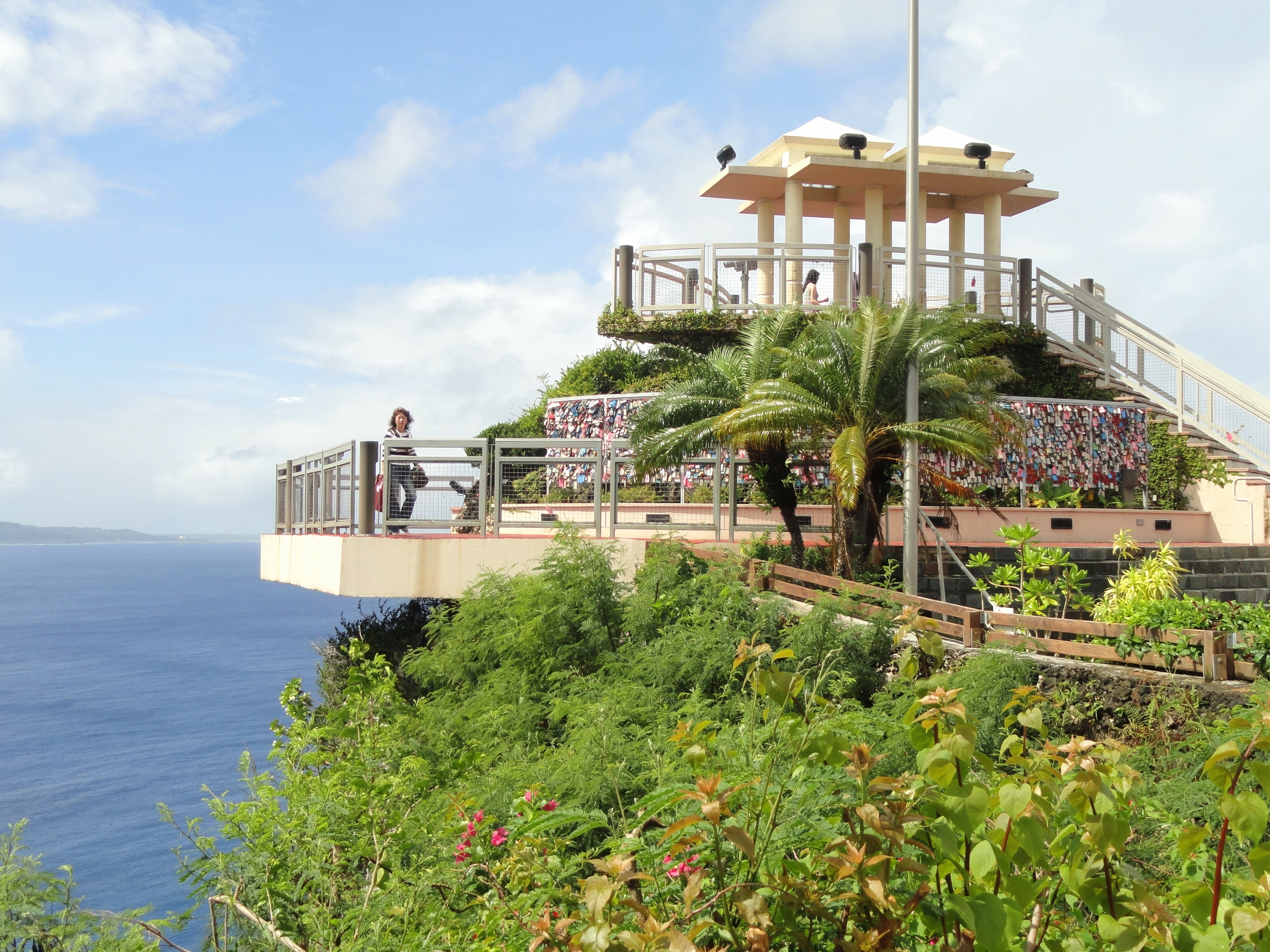
What makes this place important: Puntan Dos Amantes, commonly called Two Lovers Point, is among Guam’s most recognisable coastal landmarks. Its position above Tumon Bay gives a perspective on reef geometry, cliff vegetation, the resort shoreline and the wider Pacific. The site is also associated with a CHamoru tale of two lovers, a cultural narrative that deserves an explanation rather than being reduced to padlocks on a tourist railing. A thoughtful visit separates the physical rock and ocean setting from the story people tell about it.
The historical or environmental context: The operator’s own website gives the cultural and visitor context of the lookout. Importantly, the page contains an update dated 16 October 2026 stating that Two Lovers Point was closed in preparation for Typhoon Champi. That direct operational notice overrides the same page’s ordinary admission fee or opening hours. A photograph taken years earlier may show a crowded observation deck, but it is not evidence of its condition after a powerful storm. Damage inspection and an explicit reopening announcement matter.
Access and safety after the storm: Do not approach the lookout or surrounding cliffs during Guam’s emergency. Once the official COR4 announcement and subsequent operator reopening permit visits, assess public transport or local road access and remain behind all barriers. Strong winds can create serious danger at exposed clifftops even outside a typhoon. Avoid unapproved drone flying, and do not venture into neighbouring vegetation to obtain an unobstructed view. If the operator remains closed, study the site through official information instead of improvising an alternative route.
Question for a family notebook: Compare a 2011 archive image of the lookout with a dated current operator notice. Explain why an older photograph can be accurate about a landmark’s appearance but unreliable for today’s access or safety.
Return to ten-place index · Next place
6. Tumon Bay and Ypao Beach Park
What makes this place important: Tumon is the best-known resort district on Guam, but its shores and parks also connect visitors with coastal habitats and histories that predate modern hotels. Ypao Beach Park sits toward the southern end of the bay, while the broader shoreline offers views toward Two Lovers Point. Once safe and open, this is a place for comparing a working visitor economy with reef protection, urban development and CHamoru cultural heritage. The sea should not be treated as safe because hotel towers face it.
The historical or environmental context: The Guam Visitors Bureau’s history walk identifies Ypao Beach Park and discusses historical uses of the area, including ancient CHamoru connections. Resort infrastructure reflects more recent changes in transport and employment, so an honest guide distinguishes the beach’s ecology from the commercial businesses that serve visitors. A reef may reduce some wave energy but cannot eliminate dangerous currents or contamination following a major storm. Coral and seagrass are living systems vulnerable to disturbance by swimmers, boating and sediment washed from damaged shorelines.
Access and safety after the storm: Guam Homeland Security’s bulletin on 18 October expressly instructed people to stay away from the shoreline and out of the water. Do not swim, walk the beach or travel to a snorkelling spot during this emergency. Even after the general readiness level is lifted, wait for specific beach safety and water-quality clearance. Use approved public entry points when they reopen and follow any marine preserve signage; avoid coral contact, reef collecting and boating lanes. Public park hours may differ from hotel facilities.
Question for a family notebook: On a map, mark the reef, coastline, hotel strip and public park. Ask how runoff after severe rain might affect the nearshore habitat and what actual testing would be needed before announcing safe water.
Return to ten-place index · Next place
7. Ritidian Point and Guam National Wildlife Refuge
What makes this place important: Ritidian, or Puntan Litekyan, is a northern coastal landscape protected by the U.S. Fish and Wildlife Service. It combines limestone forest, historic CHamoru sites and a white-sand shore whose appearance can distract from ecological fragility. The refuge is particularly useful for understanding how nature conservation and cultural heritage can exist together. It is not simply a beach that someone can visit whenever a road is navigable.
The historical or environmental context: The federal refuge’s official visitor page describes native plants, birds, historical cultural features and the Ritidian Nature Center. Some archaeological paths require a ranger-led tour, and the area east of Ritidian Cut is closed for wildlife and marine protection. Normally the Ritidian Unit is open Wednesday through Sunday from 7:30 a.m. to 4 p.m., with closure on federal holidays and during hazardous ocean conditions. The pre-storm website’s normal-hours update on 7 October is not a clearance after Typhoon Champi. The refuge’s mission includes restoration of important threatened or endemic species, which require habitat protection even when no animals are visible.
Access and safety after the storm: Never attempt to walk in when the refuge is closed. The Fish and Wildlife Service explicitly states no walking entry is permitted during closure; storm and ocean hazards trigger restrictions. Wait for a fresh federal agency notice, then check which trails are available and whether guided cultural visits have resumed. There are no lifeguards at the beach under ordinary circumstances. Even once reopened, observe water-safety warnings, avoid unapproved drones and respect sites associated with traditional CHamoru settlement.
Question for a family notebook: Create a four-column note for plant, bird, rock and historical feature. For each, identify the observation, the reason for protection and one fact requiring a ranger or official record to confirm.
Return to ten-place index · Next place
8. Gef Pa’go CHamoru Cultural Village, Inalåhan
What makes this place important: Gef Pa’go in southern Guam is associated with CHamoru cultural presentations and demonstrations. A visit can offer insight into traditional skills, foodways, tools and community practices, complementing the archaeological remains displayed elsewhere. It should not be described as a fully preserved village that has never changed. Cultural presentations are created and maintained by contemporary people sharing knowledge with residents and visitors, and their participation must be respected.
The historical or environmental context: The Guam Visitors Bureau includes Gef Pa’go among places that explain traditional life, alongside other cultural sites. Interpretation can show historical practices, but a modern demonstration may adapt to a visitor audience; neither makes it less valuable. The strongest visitor question is how the presenter knows or learned the practice, how it is used in homes today and what materials it requires. CHamoru culture is living, not merely a historical costume. Inalåhan’s broader village landscape also carries memories of different historical periods that ought not be merged into one timeless tableau.
Access and safety after the storm: Typhoon Champi affected Guam on 18 October 2026, and recovery of homes and public services must take precedence over a cultural excursion. Do not visit while official movement restrictions apply. Later, contact the village organisers to confirm which demonstrations are operating, whether groups need reservations and what photography rules apply. Always ask consent for close-up photographs of craftspeople or children. Respect roads, worship sites and residences in Inalåhan, and support locally run experiences fairly.
Question for a family notebook: Choose a demonstrated craft and list the materials, sequence of work and knowledge transmitted. How would you separate an observation from a practitioner’s explanation and your own historical interpretation?
Return to ten-place index · Next place
9. Fort Nuestra Señora de la Soledåd, Humåtak (Umatac)
What makes this place important: Fort Soledad commands a view across Humåtak Bay on Guam’s southwestern shore. Its surviving defensive elements are associated with the period when Spain used Guam as a resupply point on Pacific routes between the Americas and the Philippines. The high vantage point makes the relationship between a harbour, nearby settlement and maritime security visible. It is an excellent example of how a small place can matter within a larger network of ocean travel.
The historical or environmental context: The Guam Visitors Bureau’s historic-sites account dates the fort’s construction to the early nineteenth century and links it to the Manila Galleon trade. The fort was the last of several Spanish fortifications in the vicinity. Its story includes imperial commerce, military protection and the experiences of island residents whose lives were changed by outside rule. A standing masonry feature cannot explain all those relationships alone; one should compare it with maps, shipping records and CHamoru history. The fort’s prominent position is geographical evidence of why a harbour approach mattered.
Access and safety after the storm: Do not travel to southern Guam during the present typhoon response. Government bulletins identify the southern villages as facing severe winds and flooding. Once public movement resumes, obtain current municipal guidance on whether the fort road, parking and clifftop viewpoint have been inspected and reopened. Stay away from damaged masonry and edges, and never enter a closed or unstable section. Do not invent access through military land or adjacent private property if the public route remains restricted.
Question for a family notebook: From a safe authorised viewpoint, identify the harbour entrance and plausible directions of ship approach. Why did a defended resupply point matter to long-distance voyages, and what information would ships need that a fort could not provide?
Return to ten-place index · Next place
10. Inalåhan Natural Pools and southern village landscape
What makes this place important: The natural pools near Inalåhan offer an accessible-looking example of how reef rock and coastal formations shape shoreline spaces used by local families. Before the storm, the area was featured as a recreation stop in Guam Visitors Bureau material. A pool sheltered behind rock can appear calmer than the open ocean, but it remains connected to weather and sea conditions. The place can be an excellent example of physical geography, yet responsible travel writing must resist presenting it as a swimming invitation immediately after a major typhoon.
The historical or environmental context: The official visitors bureau describes the Inalåhan pools near the village and treats the setting as part of a southern Guam outing. The protected feel of shallow water is not proof of safety because waves can overtop barriers, currents may persist and damaged shore infrastructure may remain hazardous. The nearby village has its own local history and contemporary civic life. Rather than viewing a neighbourhood as a backdrop to a swimming photograph, consider how a shared recreation area is maintained, used and repaired by residents.
Access and safety after the storm: The 18 October emergency instructions explicitly say to remain indoors and stay away from the shoreline. No swimming, wading, pool jumping or coastal exploration is appropriate while that order is in force. After official all-clear, seek specific municipal updates about damage, steps, water quality and current sea conditions. Do not use old promotional photographs as a safety assessment. A family can study the geology from official maps or a safe inland public viewpoint if the pools remain closed.
Question for a family notebook: Draw a simple cross-section showing outer waves, a rock barrier and the pool area. Explain why breaking waves may still create dangerous water motion inside an apparently protected feature, and what observations or monitoring would be needed to reopen it safely.
Return to ten-place index · Reopening and planning
When will touring be appropriate again?
The next sensible action is not to book a tour. It is to check the Government of Guam Homeland Security and National Weather Service announcements. The 18 October 2026 bulletin directs people to remain sheltered at COR1 until COR4 is announced. That order must be obeyed. COR4 is the starting point for further decisions, not a universal declaration that every beach, hotel, heritage building or road is safe.
Once the emergency level changes, island infrastructure may require inspections and restoration. Airlines, the airport, ports, roads, electricity supply, water, museums, parks and shoreline operators may each follow different recovery calendars. Two Lovers Point was closed before the storm; the federal Ritidian Refuge also closes in hazardous ocean conditions and prohibits walk-in access while closed. Do not use a normal-hours listing that predates the storm as proof of reopening.
A practical sequence for future travellers
- Check the most recent Guam Homeland Security release and follow its specific instructions. Do not travel while COR1 or any stay-sheltered order remains in effect.
- After an official COR4 declaration, check airport and port reopening, hotel facilities and current travel advisories. General movement permission does not reopen every attraction.
- Confirm directly with Two Lovers Point’s operator, the National Park Service and U.S. Fish and Wildlife Service before visiting their facilities. Each can have separate closure notices.
- Wait for explicit safe-water guidance before visiting Tumon, Ypao, Ritidian or Inalåhan Pools. Shoreline damage, debris, contamination and dangerous surf can persist.
- Respect CHamoru neighbourhoods and villages whose residents may be rebuilding. Tourism businesses may not be ready to welcome visitors, and residents’ recovery takes priority.
- Do not cross washed-out roads or approach fallen wires, unstable trees, damaged railings and unsafe historical masonry to obtain photographs.
- When the situation stabilises, use the future route as an educational choice, not a promise that every district can be toured in a single day.
How a future visit might be organised
After confirmed reopening, Hagåtña’s museum and cultural sites could anchor a civic-history day. A separate National Park Service programme could focus on the wartime museum, Asan Bay Overlook and other officially open park units. Another day might be dedicated to a suitably inspected coastal viewpoint and, only when marine conditions permit, a safe beach or refuge experience. Travel toward Inalåhan and Humåtak is a different regional outing. Avoid compressing all these into a tight loop that leaves no flexibility for weather, traffic or recovery restrictions.
Frequently asked questions
Is it safe to visit Guam attractions on 18 October 2026?
No. The Government of Guam’s 18 October 12:45 p.m. emergency release instructs people to stay indoors under COR1 and to avoid the shoreline. Sightseeing and swimming should not take place under that direction.
Did Super Typhoon Champi pass close to Guam?
Yes. The Guam government reported a very close approach on 18 October, with severe winds and continuing dangerous conditions. Refer to official bulletins for updated assessments rather than relying on a historical travel description.
Is Two Lovers Point open?
Its official operator posted a closure notice on 16 October 2026 in preparation for Typhoon Champi. A subsequent clear reopening confirmation is needed before planning an admission visit.
Is the National Wildlife Refuge at Ritidian open all the time?
No. It normally has a fixed Wednesday–Sunday daytime schedule and closes during hazardous ocean conditions or relevant advisories. The Fish and Wildlife Service explicitly prohibits walk-in entry while it is closed.
Is Tumon Bay safe for snorkelling after the typhoon?
Do not assume so. Guam’s emergency bulletin orders people out of the water, and later re-entry should depend on specific marine safety and local water-quality guidance.
Why include the Asan Bay Memorial Wall?
It commemorates Guam residents and U.S. service members affected by the Pacific War. Its interpretation places CHamoru civilians and their losses within the historical account.
Do cultural villages and museums reopen automatically at COR4?
No. The end of a general shelter order does not guarantee that each operator’s buildings, roads, staff or visitor programmes are ready. Obtain site-specific confirmation.
Learning from Guam while access is suspended
Guam offers a powerful lesson in the difference between a place’s enduring importance and its current accessibility. A monument can be historically significant while its stairs are storm-damaged; a reef can be ecologically valuable while conditions prohibit swimming. Readers can compare a dated archive image of Two Lovers Point, an official site closure notice and a new government emergency bulletin. Each source answers a different question, so none replaces the others.
Families can construct a clear historical map: ancient CHamoru places, Spanish-era sites, the Pacific War landscape and contemporary conservation areas. Mark one example of each and state which source supports it. The reasoning principle is similar to eduKate’s Secondary 1 Mathematics Tutor Clementi | Small Groups Tutorials, where a complete explanation must show not only a conclusion but how its evidence was obtained.
Continue learning about Guam
Top 10 Things to Do When Visiting and Touring Guam · Top 10 Things to Learn When Visiting and Touring Guam · World Country Directory
Official emergency and heritage sources
Sources reviewed 18 October 2026, Singapore time. The cited 12:45 p.m. Guam emergency bulletin takes precedence over ordinary tourism descriptions. This page is intended for future reading and must be rechecked as the typhoon response changes. The featured image is a 2011 archival photograph, clearly labelled as such.
- Government of Guam Homeland Security — 18 October 2026 COR 1 and stay-indoors release
- Government of Guam Homeland Security — latest emergency updates
- Two Lovers Point operator — 16 October 2026 closure notice
- National Park Service — War in the Pacific National Historical Park
- National Park Service — park units, museum and access
- National Park Service — Asan Bay Overlook memorial
- U.S. Fish and Wildlife Service — Ritidian refuge visitor conditions
- U.S. Fish and Wildlife Service — refuge hours and storm restrictions
- Guam Visitors Bureau — first-time visitor cultural and historical sites
- Guam Visitors Bureau — official historic sites and Fort Soledad
- Guam Visitors Bureau — Gef Pa’go and cultural presentations
- Guam Visitors Bureau — Inalåhan natural pools
- Wikimedia Commons — archive photo by Daderot (CC0)