
Quick answer: The ten places that best introduce Madeira are Funchal’s historic centre and Monte’s gardens for culture, Pico do Areeiro and Pico Ruivo for high mountains, Rabaçal and Fanal for water and laurel forest, Ribeiro Frio for accessible forest interpretation, Ponta de São Lourenço for exposed volcanic coast, Porto Moniz for natural pools, Cabo Girão and Câmara de Lobos for cliff and fishing heritage, and Porto Santo for a completely different island experience.
Madeira is a Portuguese Atlantic archipelago with steep volcanic terrain, subtropical vegetation, levada water channels, living communities and a long maritime history. UNESCO lists the Laurisilva of Madeira for its exceptional surviving laurel forest, not the entire island or every scenic viewpoint. A satisfying journey connects mountain ecosystems, working towns and the sea instead of presenting the destination as a continuous sequence of dramatic photographs.
Important 2026 planning change: All officially classified PR walking trails now require an online reservation through the regional SIMplifica portal and applicable fees. The famous PR1 from Pico do Areeiro to Pico Ruivo reopened with a compulsory one-way section beyond Pedra Rija and separately regulated return logistics. Trails can be open, restricted or closed. Check the live Visit Madeira and IFCN information, then choose your actual route rather than using a pre-2026 hiking description.
2026 walking-trail reservation and one-way access
Before using a classified PR trail, check the live trail status and mandatory booking rules. PR1 operates one-way beyond Pedra Rija toward Pico Ruivo under the current IFCN system; plan transport and use SIMplifica for valid permits. A historic description is not entry permission.
eduKate · World heritage and learning
Find your reading route through Madeira
Three distinct landscape regions and ten culturally or scientifically meaningful places.
ROUTE 1 · PLACES 1–3
Funchal, Monte and mountain viewpoints
Read the choices and continue to the next section.
ROUTE 2 · PLACES 4–6
Laurisilva forest, levadas and the east coast
Read the choices and continue to the next section.
ROUTE 3 · PLACES 7–10
North coast, cliffs and Porto Santo
Read the choices and continue to the next section.
Choose your ten places
Each place answers a different cultural or environmental question. This is a selection guide rather than a claim that every stop fits one drive.
| Place | Why visit? |
|---|---|
| 1. Funchal Old Town, harbour and Mercado dos Lavradores | Discover the historic capital and everyday market culture. |
| 2. Monte, gardens and Funchal hillside viewpoints | Explore landscape design and a historic hill district above the city. |
| 3. Pico do Areeiro, Pico Ruivo and the regulated PR1 | Understand a high volcanic landscape and the new one-way hiking rules. |
| 4. Rabaçal and the 25 Fontes levada landscape | Follow Madeira’s water systems through a green forest environment. |
| 5. Fanal forest and the Laurisilva of Madeira | Study ancient-looking trees within a UNESCO-recognised forest ecosystem. |
| 6. Ribeiro Frio and the Balcões viewpoint trail | See laurel-forest vegetation through a shorter mountain walk. |
| 7. Ponta de São Lourenço coastal peninsula | Compare exposed volcanic cliffs with Madeira’s greener interior. |
| 8. Porto Moniz and its volcanic natural swimming pools | Read a volcanic coast and the boundary between managed pools and open ocean. |
| 9. Cabo Girão and Câmara de Lobos fishing town | Pair a high sea cliff with a living fishing harbour and its history. |
| 10. Porto Santo island and its long sandy coast | Discover the other principal inhabited island of the Madeira archipelago. |
1. Funchal Old Town, harbour and Mercado dos Lavradores
Why this place deserves time. Funchal is a strong beginning because its harbour, historic streets, cathedral and markets reveal how Madeira developed as a trading and administrative centre. Today the city supports a living cultural and economic community, with food, crafts, exhibitions and an active seafront. The Mercado dos Lavradores can introduce regional produce and the skills behind making and selling it, but it should not be reduced to a backdrop for colourful market photography. A slow city walk also demonstrates how quickly the built-up coast meets steep hills.
What to notice. Compare the compact lanes of the old centre with the broader harbourfront and uphill streets. In the market, look at how fish, fruits, flowers and prepared foods are presented, asking a vendor when it is appropriate rather than guessing every ingredient’s origin. Notice churches, public spaces and contemporary arts alongside commercial buildings; Madeira has continued to change rather than remaining a colonial postcard.
The learning question. Map the relationship between harbour, old commercial streets and the slopes above town. Why did a useful coastal landing point become a major urban centre? Choose one food item and trace its cultivation or import, transport and sale. This exercise connects geography with work and makes a more accurate account than declaring that a product is ‘traditional’ simply because it is displayed in a market.
Access and planning
Use legal public walking routes and check current market hours, exhibition opening and cable-car arrangements independently. Some streets are steep or paved with slippery stone in wet weather. Ask permission before photographing vendors and leave working port access clear. An unhurried Funchal day can be rewarding without requiring a mountain hike.
2. Monte, gardens and Funchal hillside viewpoints
Why this place deserves time. Monte presents a very different view of the Funchal area from the waterfront. Its gardens, church, hillside streets and views toward the coast offer a way to understand how elevation changes temperature, vegetation and transport. The Monte Palace Tropical Garden is known for botanical collections and designed landscapes, while the historic neighbourhood shows how residents and visitors have used the cooler high ground. The cable car and traditional wicker toboggan experience are separate attractions with their own operators, not a single universal ticket.
What to notice. Within a permitted garden or public viewpoint, compare canopy shade, ponds, paths and planted species. Distinguish curated exotic collections from Madeira’s native protected Laurisilva; a tropical garden is not automatically an example of primary laurel forest. Look down toward Funchal and consider the height difference and the routes that connect the upper slopes to the seafront.
The learning question. Draw a section from the coast to Monte and identify what changes with elevation. Ask how a designed garden differs from a natural protected forest in management, plant origin and visitor behaviour. This provides a useful environmental comparison before seeing Fanal or Ribeiro Frio. The history of hill transport also shows how engineering affects visitor access.
Access and planning
Check current garden admission, weather, cable-car timetable and the eligibility of anyone considering the toboggan attraction. Uphill pavements and garden paths can be uneven or wet. Avoid suggesting that cable-car and toboggan services always run or that every section is accessible to visitors with reduced mobility.
3. Pico do Areeiro, Pico Ruivo and the regulated PR1
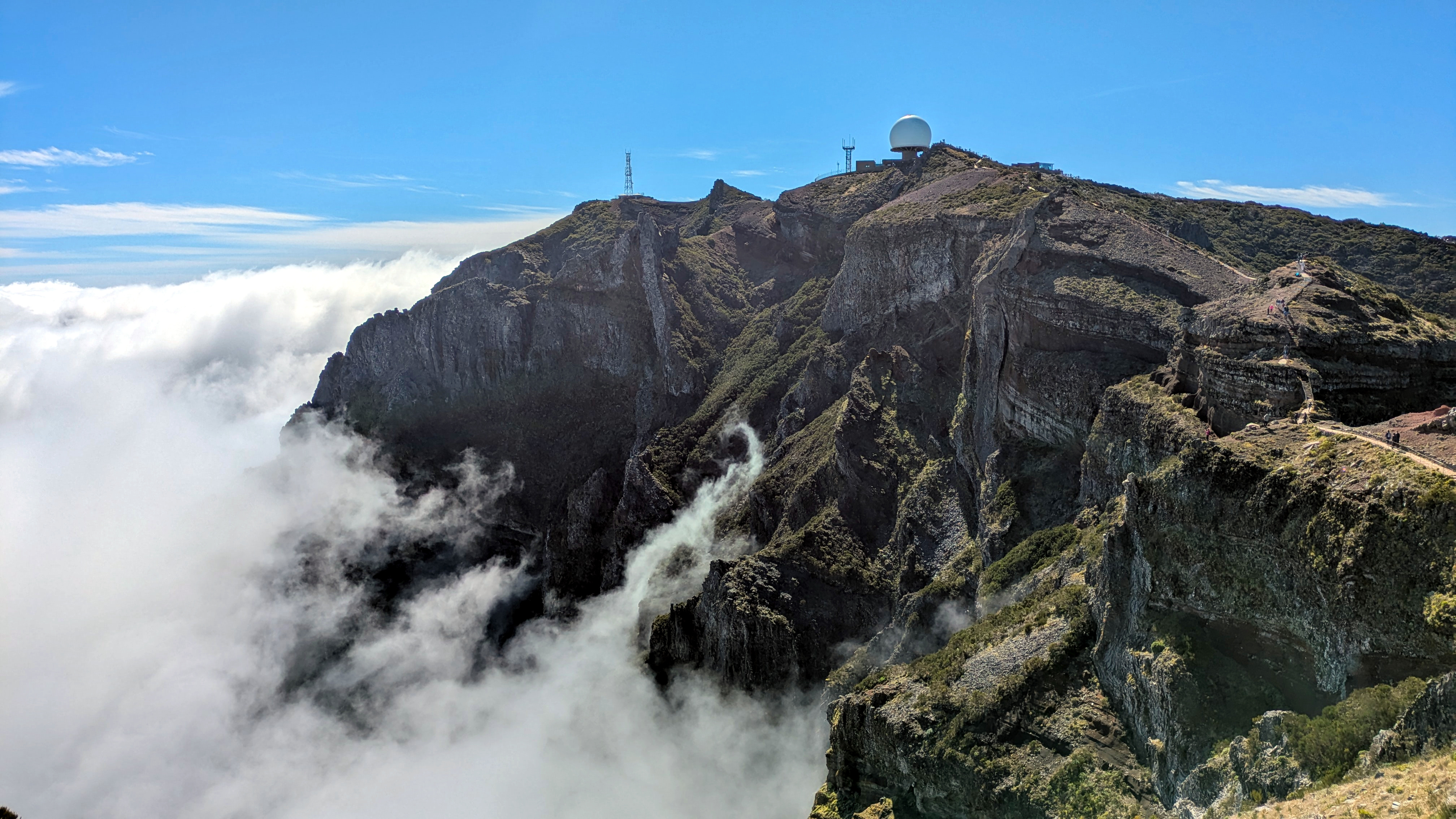
Why this place deserves time. The rocky crest around Pico do Areeiro reveals Madeira’s central mountain relief, with jagged slopes and views that may extend above clouds. The walking route toward Pico Ruivo, the island’s highest peak, is famous but has specific management requirements. Madeira’s regional forestry authority states that PR1 reopened fully in 2026; beyond the Pedra Rija viewpoint the route operates one way toward Pico Ruivo. This is an opportunity to appreciate serious mountain geography while recognising why restoration, controlled access and visitor numbers must be managed.
What to notice. From approved public viewpoints, study ridges, steep valleys and the movement of clouds around exposed rock. A clear summit on one day can be concealed by fog the next. Consider how the scale of the mountains creates barriers between places that look close together on a map. Do not approach unsafe cliffs or assume an old image of hikers shows a permitted return route.
The learning question. Compare a mountain path with a city walk of similar horizontal distance. Why can the difference in elevation produce radically different travel time and physical effort? Explain why a one-way rule requires advance transport planning. The 2026 reopening and ongoing maintenance also show how public access can be revised after storms, fires or landslides.
Access and planning
Book a valid PR-trail entry time and review the exact PR1 rules through SIMplifica and IFCN. The one-way section means walkers cannot simply return from Pico Ruivo along the same route; official exit trails and transfer logistics must be considered. Check current closures, weather, suitable equipment and fitness. A legal summit-area viewpoint is an alternative to the demanding full traverse.
4. Rabaçal and the 25 Fontes levada landscape
Why this place deserves time. Rabaçal contains several much-loved hiking paths that connect irrigation history with waterfalls, vegetation and mountain water. The Levada das 25 Fontes route is particularly useful for understanding how levadas carry water around complex slopes rather than treating every channel as an ordinary natural stream. In a protected landscape, however, the attraction of clear water does not permit swimming, shortcuts or entry to closed areas. Carefully choosing a route is more valuable than rushing through several waterfall names.
What to notice. On a permitted trail, notice the channel’s alignment with the contour of the slope and differences in vegetation between wetter and drier sections. A levada may look level but have narrow paths or steep drops beside it. Observe how water moves around the mountain while keeping away from exposed edges. The forest and waterfall setting can be appreciated without leaving maintained paths.
The learning question. Draw a hillside with a levada following the contour, then explain why channels can distribute water without always needing a steep descent. Compare human-built water infrastructure with naturally eroded waterfalls and streams. This makes an excellent example of environmental engineering responding to mountainous terrain.
Access and planning
The PR6 and related official routes are covered by Madeira’s 2026 mandatory booking system, and specific paths may be closed or restricted. Reserve the correct trail and time, check the live status, wear appropriate footwear and never climb over barriers. Rain and tunnel conditions may affect access; bring suitable lights if the approved route requires them.
5. Fanal forest and the Laurisilva of Madeira
Why this place deserves time. Fanal in the highlands is famous for mossy tree forms, mist and unusual woodland scenes. It provides a useful introduction to the wider Laurisilva of Madeira, which UNESCO recognises as the largest surviving example of a once more widespread laurel-forest type. The heritage significance is ecological rather than simply photographic: endemic species, soil, water cycles and long-term forest processes all matter. Mist can make the landscape magical, but it also changes visibility and navigation.
What to notice. From authorised routes, observe tree shape, mosses, understory plants and where moisture collects, without stepping through sensitive growth for a photograph. Do not assume every tree is the same age or species based on appearance. Fog can hide familiar landmarks, and wet ground can be slippery. A compact observation from a marked path can teach more than wandering into closed woodland.
The learning question. Ask how an Atlantic cloud forest helps regulate water and supports species found in limited places. Compare protected native forest with the planted gardens of Monte. UNESCO’s listing relates to biodiversity and ecosystem processes, not a promise that every picturesque trunk lies inside the inscribed boundary.
Access and planning
Check the exact trail and park access notices for Fanal and the high plateau. Classified PR trails require reservations when using them; nearby roads and picnic areas may have different rules. Respect grazing animals, conservation notices and fragile soil. Avoid driving or hiking into dense mist without a reliable route.
6. Ribeiro Frio and the Balcões viewpoint trail
Why this place deserves time. Ribeiro Frio gives visitors an accessible way to learn about Madeira’s wetter, forested slopes, with the Balcões trail leading to a viewpoint when open. It can be more realistic than an all-day mountain traverse for people who want forest interpretation without severe elevation gain. The area also highlights the relationship between conservation, public water systems and tourism. A viewpoint may offer an impressive panorama of peaks and valleys, but cloud cover can remove it altogether.
What to notice. Along an authorised path, compare vegetation, small waterways and the forest cover above the valley. Listen for bird activity without claiming a rare endemic sighting unless confident about identification. From the viewpoint, mark the direction of visible ridges and settlements using a map. Do not approach the edge or climb barriers for a clearer photograph.
The learning question. Compare a forested levada-associated path with the high exposed PR1 ridge. What differences would you expect in temperature, wind, humidity and the stability of walking surfaces? A travel notebook can record the conditions that actually occurred and identify what scientific claims require a trusted ecological source.
Access and planning
Check the official status and reservation requirements for the specific Balcões route before travelling. Weather and restoration works may alter access. Use shoes suitable for muddy forest paths and be mindful of crowding at a small lookout. If conditions are poor, an official forest interpretation stop can be a worthwhile substitute.
7. Ponta de São Lourenço coastal peninsula
Why this place deserves time. The eastern Ponta de São Lourenço peninsula has a strikingly different character from the island’s misty Laurisilva. Sparse vegetation, colourful eroded rock and open sea views make it a powerful place to understand exposure, wind and geological time. The official PR8 route is a well-known coastal hike, but it crosses a sun-exposed and sometimes windy setting whose apparent simplicity from a photograph can mislead inexperienced walkers.
What to notice. From authorised viewpoints, observe layered rock colours and the shape of the coastline. Notice how vegetation is shorter or more sparse than in wetter interior forest. Keep far back from cliff edges; dry, dusty and windy conditions can complicate footing. Looking across the sea may reveal nearby offshore islets, but landing permissions are separate from what can be seen.
The learning question. Draw a comparison between the peninsula and Fanal forest: what does contrasting vegetation suggest about moisture, soils and exposure? Ask how an eroded volcanic peninsula can reveal differently coloured rock while modern scientific mapping is needed to establish detailed formation history.
Access and planning
PR8 is among the trails covered by the 2026 mandatory reservation system. Verify whether the full route or any portion is restricted and plan water, sun protection, fitness and a safe return. Do not cross barriers or attempt informal descents to the water. Boat trips require appropriate local operators and marine-weather checks.
8. Porto Moniz and its volcanic natural swimming pools
Why this place deserves time. Porto Moniz’s natural pools are formed within volcanic rock, and the official tourism board describes how seawater enters the pools. The town’s visitor facilities and rock formations make a useful contrast with sandy beaches elsewhere. There are managed pools with support facilities and other less-developed bathing spots nearby, so readers should not assume identical entry rules, accessibility or supervision. The waves and rocks themselves are important parts of the landscape.
What to notice. Observe the shapes of rock boundaries and how ocean water moves against them. The open Atlantic can produce large waves even when a photograph shows calm pool water. Compare a constructed edge or managed entrance with natural rock platforms; each has different hazards. Look beyond swimming at the town’s history and its relationship to north-coast roads and fishing.
The learning question. Ask how cooling lava can produce rock coastlines that later become modified by waves. Compare an enclosed saltwater pool with open sea swimming, distinguishing relative shelter from guaranteed safety. A small drawing showing seawater exchange can lead to questions about water renewal and tides.
Access and planning
The official tourism site describes the Porto Moniz pool complex and separate Cachalote pools with different facilities. Check actual admission, life-saving supervision, weather closures and the condition of pathways. If waves are heavy, use a safe walkway or overlook rather than entering water. Never climb wave-washed rocks for photographs.
9. Cabo Girão and Câmara de Lobos fishing town
Why this place deserves time. Cabo Girão is celebrated for its extraordinary sea-cliff viewpoint, while nearby Câmara de Lobos is a working town historically associated with fishing and maritime culture. Combining them in one south-coast outing provides a useful contrast between dramatic topography and the way communities use sheltered coastal water. The cliff viewpoint has managed visitor access, while the town has ordinary public streets and businesses. Neither should be reduced to one celebrity photograph or social-media viewpoint.
What to notice. From approved platforms at Cabo Girão, look at the steep drop to the coast and the relationship between cultivated terraces and rock. At Câmara de Lobos, notice small boats and how a harbour shelters them from swell. Compare the working waterfront with the higher lookout without trespassing on private terraces or fishery equipment.
The learning question. Sketch a cross-section of a sea cliff and a sheltered cove. Why might a fishing community prefer one while a viewpoint is constructed at the other? A cultural learning question concerns how modern business and older maritime skills coexist, and why a famous artistic depiction cannot fully represent present-day community life.
Access and planning
Check current Cabo Girão access and any admission arrangements. Respect barriers and avoid looking down from unstable ground outside the viewpoint. In Câmara de Lobos, ask before photographing working crews and avoid blocking quays. Driving distances may appear short but roads and parking can still take time.
10. Porto Santo island and its long sandy coast
Why this place deserves time. Porto Santo is a separate island northeast of Madeira, famous for a long sandy beach and gentler-looking coastal terrain. It is an important inclusion because an archipelago guide should not imply that all its character resides on Madeira Island itself. Porto Santo has its own settlements, social life, history and landscape, including the town of Vila Baleira. Its sandy coastline provides a powerful contrast with the volcanic pools of Porto Moniz and the high cliffs of Madeira.
What to notice. Observe the shoreline’s broad sandy forms and compare them with the rockier coasts on Madeira. Notice how settlement, roads and visitor services lie closer to more level land. Beaches can appear calm in promotional photographs but have current and wave risks on the day. Town museums and local cultural venues may add historical context if operating.
The learning question. Ask why two islands of the same archipelago can have such different visible coastal forms. Use geology and wave exposure as hypotheses that need reliable sources, not simply guesses from photographs. A second question is how people organise supplies and transport where a ferry or aircraft connects their island to a larger regional centre.
Access and planning
Porto Santo requires a separate ferry or flight and should be planned as an independent island commitment rather than a short road detour from Funchal. Check departures, island transport, accommodation, beach safety and venue access. A dedicated stay is often more meaningful than an exhausting same-day checklist.
Plan a thoughtful Madeira journey
Book the correct PR walking trail. Under Madeira’s January 2026 rules, classified trails require a SIMplifica reservation and relevant payment. The general visitor fee is listed as €4.50 on the official tourism hiking page, while the full PR1 option has different terms and a separate price. Fees, exemptions and route conditions may change; rely on the current booking portal.
Plan PR1 as a one-way traverse where required. IFCN says the trail is bidirectional only from Pico do Areeiro to Pedra Rija, then one-way toward Pico Ruivo. A proper visit needs a prearranged lawful exit route and transport, not an assumption that hikers can turn back along the same path.
Keep the UNESCO language precise. The Laurisilva of Madeira is the World Heritage property, recognised for biodiversity and ecological processes. Porto Moniz pools, Cabo Girão, Funchal and every levada are not automatically within the World Heritage boundaries or separately UNESCO-listed.
Allocate geography realistically. Funchal and Monte make sense together, while mountain trails, north-coast pools and eastern headlands need their own travel and weather windows. Porto Santo requires a sea or air crossing. A few meaningful days are preferable to attempting all ten as a single route.
Be a good visitor to the forest and towns. Follow current restrictions, stay off fragile Laurisilva ground, and keep marine wildlife undisturbed. Ask permission before photographing fishers, market sellers or identifiable residents. Support locally led interpretation rather than treating everyday work as an outdoor exhibit.
Check conditions independently from scenery. A beautiful summit photo does not promise clear weather or open trails, and a calm rock-pool photograph cannot establish safe swimming. Cloud, landslides, wind, rainfall and Atlantic swell must be assessed on the day.
Frequently asked questions
Do Madeira hiking trails need advance reservations in 2026?
Yes. Madeira’s tourism board states that all classified PR trails require reservations through SIMplifica, with fees or relevant exceptions under the current rules.
Can I walk the PR1 from Pico do Areeiro to Pico Ruivo and return the same way?
Not along the full route under the 2026 management rules. Beyond Pedra Rija the official trail is one-way toward Pico Ruivo; you must arrange an authorised exit and onward transport.
Is all of Madeira a UNESCO World Heritage Site?
No. The UNESCO inscription concerns the Laurisilva of Madeira, a designated natural forest property with exceptional ecological importance.
Is Porto Santo connected to Madeira by road?
No. Porto Santo is a separate island reached by sea or air connections, subject to current schedules and weather.
Can I swim at Porto Moniz whenever it looks calm?
No. A pool may be closed or unsafe due to strong swell, and managed pools have their own admission and supervision. Follow the current local instructions.
Which places are better for visitors who do not hike?
Funchal, Monte’s accessible sections, suitable viewpoints at Cabo Girão and Porto Moniz and approved Porto Santo attractions can provide substantial experiences without a demanding mountain trek, subject to each site’s accessibility.
Build understanding through evidence
Madeira rewards comparing three distinct kinds of knowledge: the built irrigation system of levadas, the natural ecology of the UNESCO Laurisilva forest, and historical settlement along the harbour coast. Good explanations distinguish what you can observe on a short visit from climate, geological and historical conclusions that require measured evidence. A practical map can combine elevation, travel time and weather contingencies to support genuinely better decisions.
For family study, compare the straight-line distance between Funchal, Pico Ruivo and Porto Moniz with a realistic combination of road, trail and return transport. Explain the assumptions, and avoid inventing missing travel times. This is the same transparent reasoning promoted by eduKate’s Secondary 1 Mathematics Tutor Clementi | Small Groups Tutorials.
Continue learning about Madeira
Top 10 Things to Do When Visiting and Touring Madeira · Top 10 Things to Learn When Visiting and Touring Madeira · World Country Directory
Sources and current information
Sources checked on 19 October 2026 (Singapore time). Access fees, official PR walking trails and their status may change, and an old reopening notice is not a guarantee of safe or permitted access. Check current weather, official route status, venue opening and boat or ferry arrangements before booking.
Featured photograph: Pico do Areeiro, Madeira, photographed by Krib, 27 March 2025. Creative Commons BY-SA 4.0, via Wikimedia Commons. Used unchanged; the historic view does not show current trail access.

- Visit Madeira — live hiking trails, access fees and 2026 reservations
- Madeira IFCN — official trail notices and PR1 one-way rules
- SIMplifica — government reservation portal for classified trails
- UNESCO World Heritage — Laurisilva of Madeira
- Visit Madeira — natural pools of Porto Moniz
- Visit Madeira — natural swimming pool overview
- Visit Madeira — Porto Moniz municipal destination
- Visit Madeira — Madeira archipelago official tourism site
- Visit Madeira — 2026 hiking rules explained