
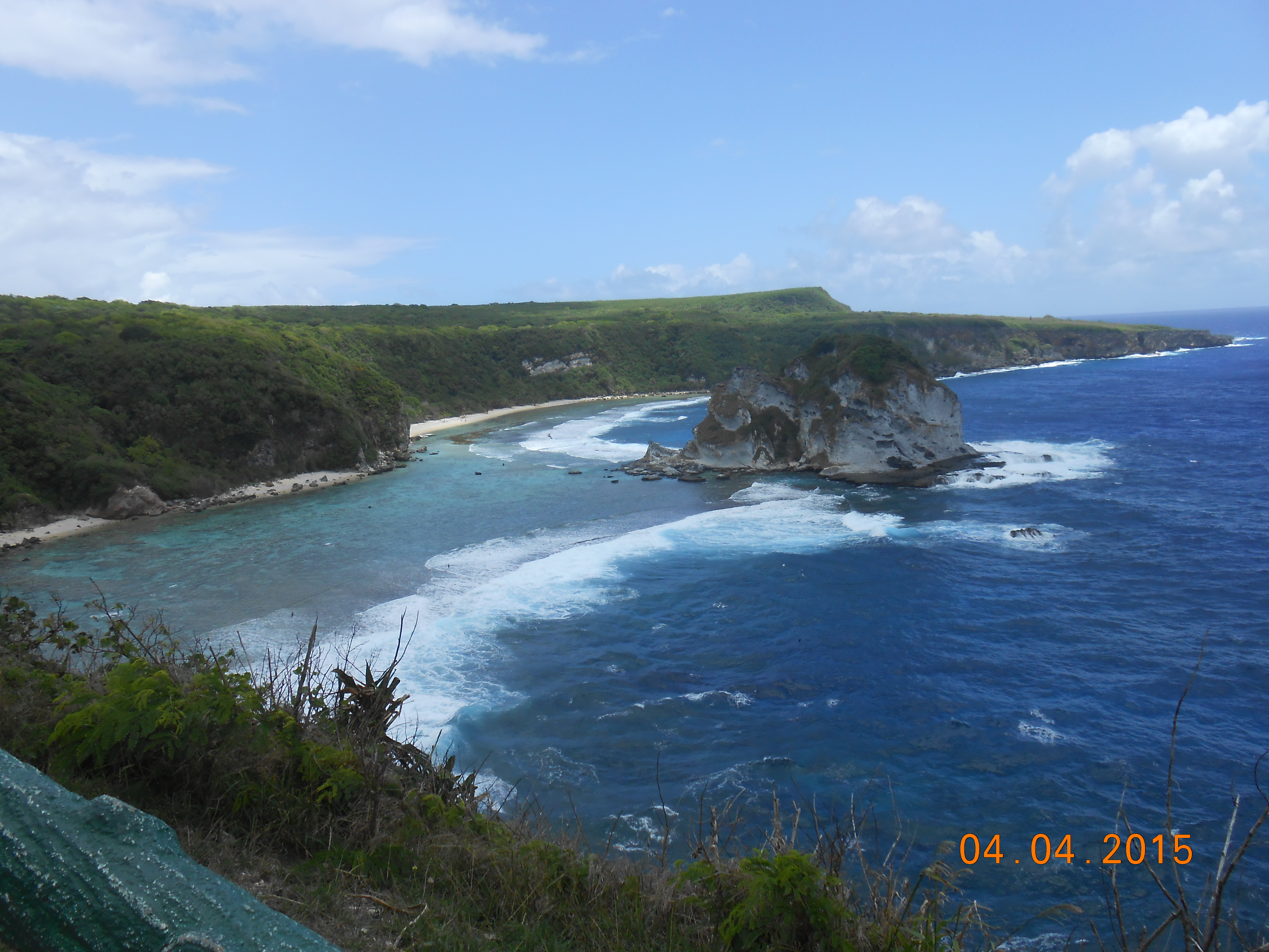
The Northern Mariana Islands are a U.S. commonwealth in the western Pacific, with distinctive communities and landscapes across Saipan, Tinian and Rota. Saipan offers a protected lagoon, busy Garapan and important memorials connected with the Pacific War. Tinian adds an ancient CHamoru latte-stone site and an airfield with worldwide historical consequences. Rota offers its own villages, forests and seabird habitats. The islands should be understood as a group of inhabited places, not one continuous tourist road.
October 2026 access update: the Marianas Visitors Authority began improvement works on 3 September at Bird Island Lookout, Last Command Post and Suicide Cliff, with completion expected in summer 2027. This affects how visitors should interpret older route advice. The National Park Service also reports a limited weekday schedule for its American Memorial Park visitor centre, different from some older webpages.
These ten locations have been selected for diversity of learning, not for a claim that a traveller can reach all of them on one short holiday. A lookout, solemn memorial, reef excursion and active cultural street call for different behaviour. On Tinian and Rota, a separate air transfer and local ground transport are part of the real travel experience. Choose only what fits your time, mobility and the actual access notices.
eduKate · Pacific islands, history and evidence
Choose your Northern Mariana Islands route
Ten places at a glance · Saipan city and coast · Tinian archaeology · Rota nature · Practical planning
Bird Island Lookout, Last Command Post and Suicide Cliff are affected by the 2026–27 Marpi improvement programme. Confirm open areas locally.


Compare the ten places
The table separates the reasons to go from the most important visitor restriction. The choice is not between good and bad places: it is between different sorts of heritage, ecology, transport and physical effort.
| Destination | What it offers | What to check |
|---|---|---|
| 1. American Memorial Park and the visitor centre, Saipan | World War II history and a living public park | Museum open only on selected weekdays |
| 2. Bird Island Lookout, northern Saipan | Limestone coast, seabirds and protected water | September 2026 site works through summer 2027 |
| 3. Saipan Grotto limestone pool | Ocean-connected cave geology with significant risk | Ocean surge, steep stairs and diving expertise |
| 4. Last Command Post and nearby northern war memorials | The physical traces and human toll of the Battle of Saipan | 2026 construction and respectful remembrance |
| 5. Mount Tapochau (Okso Tapochau) high viewpoint | Island-scale geography from its highest hill | Steep access roads and exposed ridge weather |
| 6. Garapan town, Micro Beach and the cultural market | Contemporary Chamorro and Carolinian community life | Event hours, public beach and local traffic |
| 7. Mañagaha Island in Saipan’s lagoon | A small-island marine outing near the principal town | Licensed boats and current landing permits |
| 8. House of Taga (As Taga) archaeological site, Tinian | Major ancient CHamoru latte-stone architecture | Separate island transfer and archaeological protection |
| 9. Tinian North Field and atomic-bomb loading pits | A site of enormous twentieth-century historical consequences | Military activity, legal routes and solemn interpretation |
| 10. Chenchun Bird Sanctuary viewpoint on Rota | Limestone forest and seabird habitat on a third island | Inter-island flight and cliff safety |
1. American Memorial Park and the visitor centre, Saipan
Why visit: American Memorial Park beside Garapan is a place to begin understanding the Northern Mariana Islands through more than beaches. Its green paths, memorials and exhibits connect daily civic life with the 1944 Battle of Saipan and the wider Marianas Campaign. People come for remembrance, school events, public recreation and education. A visit is worthwhile even for someone who has never studied Pacific history, because the park’s landscape invites the basic questions of who lived here, what changed during war and how people remember it today.
Meaning and evidence: The National Park Service explains that the park commemorates both American service personnel and Chamorro and Carolinian civilians affected by the fighting. The Memorial Court of Honor, Carillon Bell Tower and Marianas Memorial address different groups and periods of memory. It would be misleading to describe them all as one unchanged war monument. The visitor-centre exhibits help connect the dates of the 1944 campaign with maps, photographs and personal stories. The town surrounding the park has changed since then, showing how a community can preserve memories while continuing to develop.
Practical visitor decisions: Check the NPS operating-hours page, which currently lists the indoor visitor centre as open Tuesday, Thursday, Friday and Saturday from 9 a.m. to 4 p.m., with holiday exceptions. The outdoor park has a separate, broader public schedule. Older NPS pages may still mention daily museum opening; use the current hours rather than repeating them. Sporting activities are restricted around certain memorial areas. If travelling with children, use an age-appropriate introduction to the loss of civilian and military lives and allow quiet time after viewing exhibits.
A learning question: Choose one inscription and one museum map. What can the inscription establish about an individual or group, and what does the map explain about location? Why are both necessary for a more complete historical understanding?
2. Bird Island Lookout, northern Saipan
Why visit: Bird Island is among Saipan’s most recognisable landscapes, a small vegetated island off its rugged northeastern coast. The official viewpoint can reveal the shape of the coast, a reef and the contrasting depths and colours of the water. This is an excellent introduction to natural history without needing to climb down cliffs or enter the sea. The scenic appeal is immediate, but the site’s conservation value is more important than whether the water happens to look bright turquoise in a photograph.
Meaning and evidence: The Marianas Visitors Authority calls Bird Island Isleta’n Maigo Fahang and notes its use by seabirds. A nesting area is not merely an attractive rock; it can require distance, limits on drone use and protection from disturbance. Visitors should learn the difference between observing a living habitat and treating it as unrestricted leisure space. Waves, reef structures and erosion shape the visible shoreline, yet exact geological dates cannot be established by a quick glance. A good field note identifies observed forms and checks their origin against scientific evidence.
Practical visitor decisions: The visitor authority announced that improvement work began on 3 September 2026 at Bird Island Lookout, Last Command Post and Suicide Cliff, with completion expected in summer 2027. Access may be changed by construction, and an older photograph does not establish that parking or viewing platforms are currently available. Seek up-to-date local advice and never cross a works barrier. Remain on a permitted public viewpoint instead of scrambling to the cove below. Strong winds can make an apparently safe photo location hazardous.
A learning question: Sketch the mainland cliff, sea channel and small islet. Compare where waves meet each, and explain what further data would be needed to estimate erosion rates.
3. Saipan Grotto limestone pool
Why visit: The Grotto is among the island’s dramatic natural features, with a deep blue pool below limestone walls connected to the open sea through submerged passages. The colour and apparent enclosure are visually appealing, but the site is not the equivalent of a municipal swimming pool. Visitors interested in geology can appreciate how rock and water interact without necessarily entering the pool. It should be described as an environment demanding careful hazard assessment, especially for anyone thinking about snorkelling or diving.
Meaning and evidence: Limestone dissolves slowly under particular conditions, creating voids and cave structures; coastal waves and tides then affect the water that enters them. That broad explanation should not be turned into an unsupported claim about the exact age of this cave. Its underwater passages may experience strong surge, changing visibility and unfamiliar depth. The Marianas Visitors Authority includes the Grotto in its guide-certification materials, an indication that the location needs knowledgeable interpretation rather than superficial advice. Marine organisms and surrounding rock require protection.
Practical visitor decisions: Use an authorised and properly trained operator if considering a water activity, and follow current local restrictions. Entering the water alone, jumping from a wall or attempting a cavern dive without specialised experience can be dangerous. The stairs may be physically challenging and slippery in wet conditions. A traveller with mobility limitations, young children or low confidence in deep water should choose an above-ground scenic alternative. Do not assume a social media clip shows conditions on the day of your arrival.
A learning question: Draw an idealised section of the Grotto, showing submerged connections. Explain how the geological question of cave formation differs from the safety question of how today’s currents move.
4. Last Command Post and nearby northern war memorials
Why visit: The Last Command Post at Saipan’s northern end gives visitors a view of reinforced wartime defensive works and later displays of weapons. Its setting belongs to the broader Marpi landscape, associated with battles, civilian suffering and places of remembrance. It is not a free-standing attraction that can be understood through military hardware alone. A thoughtful route uses official interpretation and pays attention to the lives of island residents and others who endured the conflict.
Meaning and evidence: The Marianas Visitors Authority distinguishes the public site called Last Command Post from the actual final command cave of Lt. General Yoshitsugu Saitō, situated near San Roque. This prevents the common error of assigning all actions of the final Japanese command to the publicly displayed cave. Nearby Banzai Cliff and Suicide Cliff are especially solemn locations associated with civilian and military deaths in 1944. Visitors should understand how wartime propaganda, fear and violence affected choices without romanticising tragedy. Historic interpretation is stronger when accounts of the dead and survivors are read alongside an explanation of the terrain.
Practical visitor decisions: Construction works launched in September 2026 include Last Command Post and Suicide Cliff. Do not cross fencing or approach heavy equipment just because a map labels the site as an attraction. Older information about the route may no longer apply. Never handle historic weapons, enter unstable tunnels or climb memorials. Families can gain much from the NPS visitor-centre exhibits first and postpone a northern viewpoint if the local tourism office confirms that it is temporarily inaccessible.
A learning question: Choose one photograph from 1944 and one view of the restored or displayed site. Explain which elements are original, which were later installed and what documentary evidence would verify each.
5. Mount Tapochau (Okso Tapochau) high viewpoint
Why visit: Mount Tapochau is Saipan’s high point and provides a perspective that makes a narrow, complicated island easier to understand. From a safe authorised viewpoint visitors may be able to distinguish the western lagoon, developed coastal strips and the steeper eastern terrain. A high view also helps explain why roads and settlements do not always follow a straight line. It is most valuable for slowing down and orienting a map rather than taking a fast photograph and leaving.
Meaning and evidence: The Marianas Visitors Authority explains that the mountain consists largely of uplifted limestone and is associated with religious practices around a cross near the summit. It also identifies the elevation as significant in local geography. The view opens questions about how people navigate and settle a landscape where ridges and protected waters shape routes. These questions connect CHamorro and Carolinian history with the modern island, but a panoramic picture alone cannot establish the purposes of a prehistoric route or the age of a landform.
Practical visitor decisions: Check that roads and permitted parking are accessible to your vehicle, especially after rain. Some sections may be steep, rough or unsuitable for an ordinary low-clearance car. Weather changes quickly on an elevated ridge, and wind can make loose stones and open edges hazardous. No traveller needs to ascend during poor visibility to claim a successful visit. Use marked paths and respect any restrictions near communications installations or religious structures.
A learning question: Compare a road route from Garapan toward the mountain with a direct map line. Why would gradient, slope stability and existing settlements influence its alignment?
6. Garapan town, Micro Beach and the cultural market
Why visit: Garapan is the Northern Marianas’ main tourism and commercial district, with shops, food outlets, public streets and gathering places. Its proximity to Micro Beach and the NPS memorial park makes it suitable for an unhurried day, especially for visitors who want more than demanding outdoor excursions. The town demonstrates that the island is a living community: its residents are not simply caretakers of World War II relics or suppliers of resort services.
Meaning and evidence: The official tourism authority highlights festivals that celebrate Chamorro, Carolinian and other cultural traditions, as well as a weekly Garapan Street Market. Such events are opportunities to engage respectfully with contemporary food, art and music. They are not guaranteed to occur whenever a visitor passes through. Historic aspects of the surrounding lagoon can be studied beside present transport and economic uses. Observing a commercial street and a public beach together shows how the same coast serves different purposes over the course of a day.
Practical visitor decisions: Confirm current market dates and whether any event is affected by weather or reconstruction. Ask permission before closely photographing merchants, musicians or children. Distinguish access to a public shoreline from the use of private hotel facilities. Swimming should follow local sea-safety advice, and reef protections continue to apply near developed beaches. If outdoor conditions are unsuitable, a respectful town walk or an open indoor cultural venue may be a better choice.
A learning question: Choose one shop, one public gathering space and one coastal access point. What purpose does each serve, and how do people move between them?
7. Mañagaha Island in Saipan’s lagoon
Why visit: Mañagaha Island sits inside Saipan’s western lagoon, reachable by boat rather than road. For travellers who want a quiet view of reef water, beaches and offshore scenery, it can be appealing. Yet its popularity makes it a useful lesson in sustainable tourism. A small island’s limited land area and marine ecosystem have to accommodate visitor arrivals, permitted water activities and the ecological value of its shore.
Meaning and evidence: The NPS describes nearby Smiling Cove Marina as a departure point for lagoon excursions, while tourism materials identify Mañagaha as a distinct island stop. Reef structures provide habitats for fish, invertebrates and other organisms, but careless anchoring, fin contact or litter can damage them. Small islands can also carry cultural and historic associations that deserve respect. The fact that a tour operator can transport guests does not prove every landing site or area of the island is freely available for recreation.
Practical visitor decisions: Book with a reputable authorised operator and check current ferry or excursion schedules, landing conditions and any admission or conservation fee. An appealing advertisement cannot guarantee a departure during rough weather. Avoid touching reef animals, taking coral or crossing restricted nesting zones. Keep children supervised around boats and remember that shallow-looking water is not always free of currents. Visitors unsure about marine activities can enjoy the island from a designated dry-land area if conditions permit.
A learning question: Mark the mainland, lagoon, reef and islet on a map. Why might an apparently short boat trip need more planning than a longer journey by road?
8. House of Taga (As Taga) archaeological site, Tinian
Why visit: House of Taga on Tinian is an extraordinary surviving expression of CHamoru stone-building traditions. Its monumental latte pillars and capstones provide a link with precolonial settlement patterns that predates the island’s wartime infrastructure by centuries. A visit can teach how people used material, labour and knowledge to create structures that still attract archaeological study today. The site is important precisely because it is not a reconstructed fantasy village.
Meaning and evidence: The Marianas Visitors Authority describes As Taga as part of a larger Latte Period settlement and connects it with oral stories of Chief Taga. The surviving architecture and the cultural traditions are different forms of knowledge. Archaeologists study construction methods, layout and associated deposits; community stories preserve relationships and meaning. The correct approach is to value both without asserting that a legend’s details are independently verified. The site’s scale can be impressive without touching or climbing the stones.
Practical visitor decisions: Tinian requires separately confirmed flights or other authorised inter-island transport from Saipan. Arrange return connections, local transport and access information before travelling. Follow all signs at the archaeological site, and never climb pillars, move stones or remove fragments. Avoid guessing that every visible feature belongs to the same century. A local cultural guide can explain what scholars know and what remains debated.
A learning question: Draw a latte pillar and capstone and write one engineering question about stability, plus one archaeological question about how the structure was used.
9. Tinian North Field and atomic-bomb loading pits
Why visit: North Field on Tinian became a vast American air base in World War II. Two atomic-bomb missions departed from its runways in August 1945, making the location central to understanding how industrial-scale aviation and military logistics transformed conflict. A visitor should approach the site as a place of historical inquiry and human remembrance rather than as a novelty engineering exhibition. The preserved landscape cannot explain the tragedy of Hiroshima and Nagasaki by itself, but can prompt further learning.
Meaning and evidence: The Marianas Visitors Authority describes the construction of the large B-29 airfield after American forces captured the island in 1944, and the pit facilities used for loading the atomic bombs. North Field also reflects the role of Japanese and American forces on Tinian and the experience of the local CHamorro population. Separating the engineering purpose of a pit from the suffering caused by the weapons is essential. A responsible guide acknowledges the enormous civilian losses in Japan and the moral complexity of the event without reducing everything to a celebratory aviation milestone.
Practical visitor decisions: The wider area may be connected with contemporary U.S. military training and restricted access. Check with local authorities before using roads or entering sites; an old military runway is not automatically a public scenic drive. Keep to signed and permitted sections, avoid unstable structures and treat war remains with respect. A Tinian day should include the House of Taga to recognise the island’s much longer prewar history.
A learning question: Make a timeline with three categories—technical infrastructure, dated military event and human consequence. Why does a surviving concrete pit support only part of the historical account?
10. Chenchun Bird Sanctuary viewpoint on Rota
Why visit: Rota is different from Saipan and Tinian, with coastal forest, villages and bird habitats that reward slower observation. The Chenchun Bird Sanctuary’s official overlook offers a way to understand a rugged southeastern coast and the animals that use it without walking into nesting ground. This is an ecological endpoint to a ten-place list otherwise containing heavy wartime and urban history.
Meaning and evidence: The Marianas Visitors Authority describes the sanctuary as limestone-forest terrain between Puntan As Fani and Taksunok. It also records ancient CHamorro latte-site evidence in the broader area. That pairing demonstrates how landscape can have both natural and human histories. A seabird seen from a lookout is an observation; a claim about a breeding population requires systematic monitoring. Similarly, a forest that appears untouched may have past human connections not obvious to a casual traveller.
Practical visitor decisions: Rota needs separately arranged transport and a local route plan. Confirm that the recognised lookout is open and that a nesting-season or construction restriction does not affect entry. Stay clear of cliff edges and avoid flying drones near birds. Do not enter protected forest simply to identify a nesting location. If the group cannot safely manage the access road or lookout, the official Rota guide and a local cultural venue can provide an alternative learning route.
A learning question: Compare Chenchun’s wooded cliffs with Saipan’s Bird Island. What differences might affect nesting and what evidence would be needed to make a scientific comparison?
Back to contents · Plan your trip
An island-by-island itinerary that respects real travel
A short introduction can be kept entirely on Saipan: American Memorial Park and Garapan offer a combined public-history and modern-community day. A second day can select a confirmed open coastal viewpoint, Mount Tapochau when road conditions permit or a licensed lagoon excursion. Bird Island Lookout and Last Command Post need special attention during improvement works. The Grotto is not a compulsory swim and should be treated as a demanding marine feature.
Tinian and Rota are distinct destinations. Tinian’s House of Taga and North Field together show why island history cannot be reduced either to war or to prehistoric archaeology. Rota’s bird sanctuary can suit wildlife-oriented readers, but it should not be squeezed into a short Saipan layover. Flights, accommodation, ground transport, weather and sites’ visitor rules must all be confirmed separately. A meaningful stay can focus on two or three places without collecting the entire list.
Safety, access and conservation checklist
- Confirm live access to Bird Island Lookout, Suicide Cliff and Last Command Post during Marpi improvement works begun in September 2026.
- Check NPS opening hours for the American Memorial Park visitor centre; outdoor grounds and indoor displays do not share the same schedule.
- Treat memorials connected with the Pacific War as solemn sites and interpret the experiences of Chamorro and Carolinian civilians as well as service personnel.
- Never improvise a cavern dive or jump at the Grotto; the water is ocean-connected and can experience strong surge.
- Do not touch reef organisms, disturb nesting birds or cross protected marine-zone boundaries. A short boat transfer still needs a legitimate operator.
- Confirm Tinian and Rota air arrangements and local ground travel. They are islands, not districts connected by road.
- Before visiting North Field check any contemporary military-training and public-access restrictions.
- Respect the House of Taga and Rota’s ancient latte-stone sites as fragile cultural heritage, not playground structures.
- Check hill roads, cliff weather, exposure and personal mobility. A safe scenic viewpoint is often more valuable than a strenuous closed trail.
Which theme best suits your visit?
A historical route could pair the American Memorial Park museum with Tinian’s archaeological and aviation landscapes on a properly arranged separate day. A natural-history route could use a permitted Bird Island view and a suitable protected lagoon activity, while keeping clear of wildlife. A cultural route could include Garapan’s current markets and festivals with a local interpretive programme. No one itinerary is appropriate for every family, and no excursion is worth violating a safety or conservation rule.
Frequently asked questions
Are the Northern Mariana Islands and Guam the same place?
No. The Commonwealth of the Northern Mariana Islands is distinct from the U.S. territory of Guam, although both are in the Mariana archipelago.
Why are Bird Island Lookout and Last Command Post subject to changed access?
The Marianas Visitors Authority began improvements in September 2026 at these sites and Suicide Cliff, with project completion expected in summer 2027. Confirm which areas remain available.
What are the current visitor-centre hours at American Memorial Park?
The NPS lists Tuesdays, Thursdays, Fridays and Saturdays from 9 a.m. to 4 p.m., except applicable holidays. Outdoor park areas follow different rules.
Can anyone swim or dive in the Grotto?
No. The ocean-connected limestone pool can have powerful surge and challenging access. Seek qualified advice and choose a safer alternative if conditions or ability do not suit the site.
Why is the House of Taga important?
It preserves major latte-stone remains associated with ancient CHamoru settlement and is linked with oral traditions about Chief Taga. The archaeological record and legends should be distinguished.
Why visit North Field on Tinian?
The site preserves infrastructure associated with B-29 operations and the atomic-bomb missions of August 1945. It calls for sensitive interpretation of the civilian losses and historical consequences.
Is Rota a short road trip from Saipan?
No. It is a separate island requiring an authorised flight or other confirmed transfer and local transport.
Are the beaches and bird viewpoints always safe?
No. Weather, sea conditions, conservation closures and construction can change access. Official local guidance takes priority over old photographs.
Use a field notebook to connect history, geography and evidence
Choose three types of place: one historical, one natural and one inhabited town. At a memorial, identify what is directly inscribed and what a museum source establishes. At Bird Island, record land and reef forms without guessing geological ages. At Garapan, note how public streets and commercial places function today without assuming that a modern scene can summarise an entire culture. For each, label an observation, source and uncertainty.
An island map also creates practical mathematical questions. A short straight line from Saipan to Tinian cannot represent the complete flight and local-ground-transport route. The correct analysis needs real schedules and access. The habit of showing each assumption and working step is illustrated by eduKate’s Secondary 1 Mathematics Tutor Clementi | Small Groups Tutorials.
Read the companion Northern Mariana Islands guides
Top 10 Things to Do When Visiting and Touring Northern Mariana Islands · Top 10 Things to Learn When Visiting and Touring Northern Mariana Islands · World Country Directory
Official references and current notices
Official tourism and NPS sources checked 19 October 2026, Singapore time. Site works, weather, permits, museum schedules and transport can change. The 2015 cover image is archival and should not be used to infer present access.
- Marianas Visitors Authority — Saipan
- Marianas Visitors Authority — Tinian
- Marianas Visitors Authority — Rota
- Marianas Visitors Authority — Marpi improvements began September 2026
- Marianas Visitors Authority — certified tour-guide programme
- U.S. National Park Service — American Memorial Park
- U.S. National Park Service — current opening hours
- U.S. National Park Service — visitor introduction
- U.S. National Park Service — memorials and people commemorated
- Wikimedia Commons — Bird Island image, CC0