
What are the best places to visit when touring Öland in Sweden? Begin with Borgholm Castle and Solliden’s royal gardens, then discover the UNESCO-listed agricultural landscape of southern Öland, Eketorp Ringfort, the Ottenby bird reserve and Långe Jan Lighthouse. In the north, visit Trollskogen, Böda’s sandy beaches, Byrums Raukar and Långe Erik; add Himmelsberga for island farm heritage. The attraction is not a single view, but the contrast between limestone, history, living villages and coast.
Öland is a long Baltic island connected to mainland Sweden by the Öland Bridge from Kalmar. The crossing is straightforward in principle, but a relaxed trip requires planning because the island’s northern and southern tips are far apart. Three to five days is a comfortable first-visit window. Instead of choosing ten famous names and driving from one end to another, plan a central heritage day, a southern World Heritage day and a northern nature-and-beach day.
October 2026 planning note: Summer attractions, royal garden access, castle tickets, lighthouse climbs and some visitor services are seasonal. This guide does not claim that every site is open today, nor give supposedly permanent ticket prices. Verify the official venue information and current nature protection rules before travel. An agricultural World Heritage landscape is also working private and public land, not a free-for-all walking field.


Start with the geography: three different versions of Öland
Central Öland is a useful introduction because Borgholm’s castle, Solliden’s gardens and the island’s towns provide clear landmarks and services. Southern Öland is the great limestone and farming landscape recognised by UNESCO, with ancient settlements, grazing land and an exceptional birdwatching coast at Ottenby. Northern Öland feels different again, with long beaches, limestone formations, coastal woodland and its own lighthouse. Treat these as different days rather than trying to do one symbolic stop in every region on a single afternoon.
That geographical plan also helps you choose where to stay. A base near Borgholm works for central and some northern activities; a base near Färjestaden or Mörbylånga may be convenient if you want more time in the south or easy access across the bridge. Families might prefer fewer accommodation moves and shorter outings, while keen birdwatchers may value early access to Ottenby. There is no universal best base: the right answer follows the part of Öland you most want to understand.
Quick guide to the ten Öland stops
- 1. Borgholm Castle: Limestone Walls and Swedish Royal History — Central-western Öland, above Borgholm
- 2. Solliden Palace Gardens and the Royal Summer Landscape — Near Borgholm Castle, central Öland
- 3. Stora Alvaret and the Agricultural Landscape of Southern Öland — Southern Öland limestone plain and farming villages
- 4. Eketorp Ringfort and Reconstructed Iron Age Settlement — Southeastern Öland
- 5. Ottenby Nature Reserve and Långe Jan Lighthouse — The southern tip of Öland
- 6. Trollskogen Nature Reserve and the Northern Forest — Far northeastern Öland, near the northern tip
- 7. Böda Sand and the Northern Beaches — Northern Öland, east coast around Böda
- 8. Byrums Raukar and the Stenkusten Stone Coast — Northwestern Öland, along the rocky western shore
- 9. Långe Erik Lighthouse and the Northern Cape — Grankullavik, far northern Öland
- 10. Himmelsberga Open-Air Museum and Öland’s Farm Traditions — Central-eastern Öland, around Långlöt
Use the entries as a menu, not a single road itinerary. Each stop has a reason to visit, practical considerations and a question that helps children or adults look more carefully. The itinerary section below groups the stops into days that respect the island’s north-south distances.
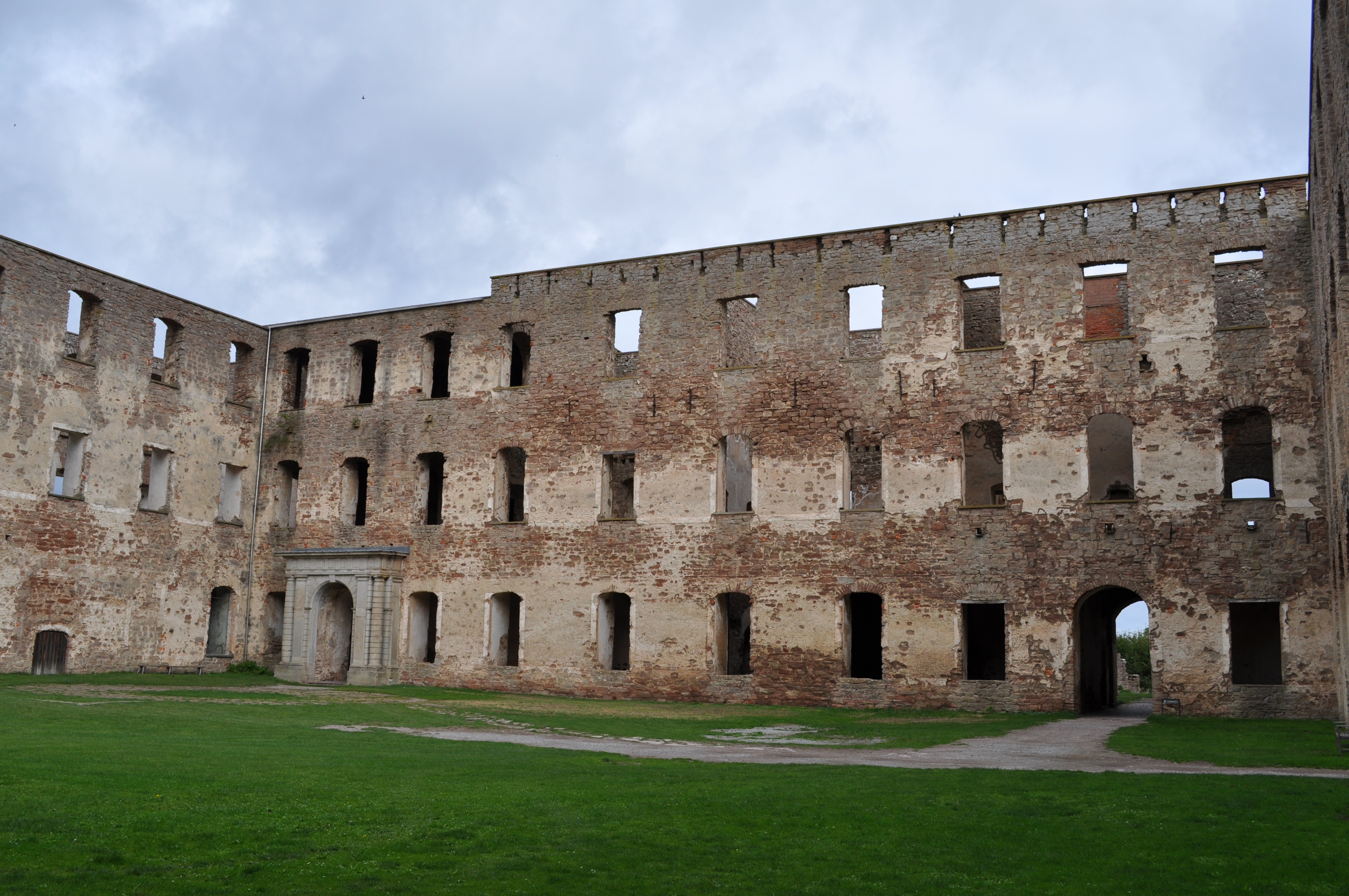
1. Borgholm Castle: Limestone Walls and Swedish Royal History
Where: Central-western Öland, above Borgholm. Best for: Medieval and early modern history.
Borgholm Castle sits above the Kalmar Strait with a presence that makes you stop before you even reach its gate. The vast ruined walls are a landmark of Öland’s long political history. What began as a fortified site later became an ambitious royal palace, and the shell you see today reflects major changes as well as the destruction caused by an early nineteenth-century fire. Walking through the old spaces is particularly rewarding if you treat them as evidence of a working complex rather than scenery. The site offers a practical way to discuss defence, architecture and the way rulers used grand buildings to communicate power.
Give the castle a meaningful visit rather than a drive-by photograph. Check entrance arrangements, exhibitions and whether particular sections are accessible on your chosen date. Stairs, exposed stone and uneven floors require appropriate footwear; if you need step-free access, contact the site rather than assuming all historic rooms are suitable. The plateau can be windy, so bring a layer even if Borgholm town feels comfortable. Combine the castle with Solliden Palace Park and a Borgholm lunch. These are close enough geographically to deserve one full, unhurried central-island day.
Ask why the castle stands high above the water. A commanding view can serve defence, control of movement and the symbolic visibility of royal authority. Then ask why a building intended to demonstrate permanence survives today as a ruin. A fire and centuries of maintenance decisions can transform the meaning of a site. Notice how modern interpretation helps you imagine spaces that no longer have floors, furnishings or daily occupants. It is a good lesson in historical evidence: what you see now is not necessarily what past visitors saw.
How to combine it: Spend a central-island half-day here and pair it with Solliden, not a rushed southern-tip drive. Opening hours, safe paths and the needs of working residents and wildlife come ahead of any suggested schedule.
Back to the top ten places · Next stop
2. Solliden Palace Gardens and the Royal Summer Landscape
Where: Near Borgholm Castle, central Öland. Best for: Gardens, architectural design and royal history.
Solliden is a striking contrast with the austere stone shell of Borgholm Castle. Built for Queen Victoria of Sweden in the early twentieth century, the summer palace is associated with landscaped gardens, formal design and the Swedish royal family’s use of Öland as a seasonal retreat. The public experience focuses on the palace grounds and gardens rather than freely entering the private royal residence. Walk from one garden style to another and you notice how horticulture, water, terraces and planned views create a setting that feels controlled even while the Baltic is close by.
Check the current visitor season and which gardens or exhibitions are open, because the site is not necessarily a year-round public park. Respect private residence boundaries and photography restrictions. A visit works best as a companion to Borgholm Castle: the two locations show different centuries and different ideas of royal life without needing two long drives. Take time for a café break if services are available. Visitors who prefer botanical detail should not rush; looking at how pathways frame plants and views is the point of a designed landscape.
Compare what makes a castle and a palace garden feel impressive. A fortress uses scale, walls and position. A formal garden uses symmetry, selected plants and perspective. Both express human decisions about land. Ask which features are functional, which are decorative and what a garden requires in water, labour and maintenance. An attractive landscape is not always effortless nature; it may be carefully managed for many generations.
How to combine it: Put Solliden and Borgholm Castle on the same heritage day; check which grounds are public. Opening hours, safe paths and the needs of working residents and wildlife come ahead of any suggested schedule.
Back to the top ten places · Next stop
3. Stora Alvaret and the Agricultural Landscape of Southern Öland
Where: Southern Öland limestone plain and farming villages. Best for: UNESCO World Heritage, geology and living farming.
Stora Alvaret looks like a place where very little happens: open limestone ground, sparse vegetation, stone walls and sky stretching across much of the southern island. In fact, this landscape tells one of Öland’s deepest stories. The wider Agricultural Landscape of Southern Öland was inscribed on the UNESCO World Heritage List in 2000 because people have adapted farming and settlement to this demanding environment over thousands of years. The heritage is not merely a protected patch of limestone; it includes grazing land, fields, coast and villages where farming remains an active part of daily life.
Use a marked public trail or an official viewpoint rather than leaving a road at random to cross fields. Some apparently open land is worked or grazed, and gates, stone walls, livestock and conservation measures must be respected. Dress for wind and bright exposure, take water, and allow a shorter walk if the weather changes. There may be few facilities near the section of alvar you choose. If you are driving south to Ottenby or Eketorp, build in time for one genuine stop rather than racing through and declaring the World Heritage landscape ‘seen’ from a car window.
UNESCO’s inscription is particularly illuminating because it recognises a continuing cultural landscape, not a frozen prehistoric exhibit. Consider why thin soils affected where people grew crops and where animals grazed. Why are stone walls so common? How does livestock grazing help maintain open habitats? Farmers remain central to the value of the place, so visitors should not treat their livelihoods as scenery. The site teaches how nature, agriculture and history can form one connected system.
How to combine it: Allow time to experience a marked portion of the living World Heritage landscape, not merely its road signs. Opening hours, safe paths and the needs of working residents and wildlife come ahead of any suggested schedule.
Back to the top ten places · Next stop
4. Eketorp Ringfort and Reconstructed Iron Age Settlement
Where: Southeastern Öland. Best for: Archaeology, daily life and family history.
Eketorp is one of Öland’s most engaging heritage sites because it lets you picture the inhabited spaces within an ancient ringfort. Its excavated and reconstructed walls and buildings give shape to a settlement that would otherwise be difficult to imagine from scattered archaeological remains. The reconstructions should be appreciated as interpretation based on archaeological evidence, not a magical window directly into the past. Visitors can compare defensive walls, domestic spaces and the basic problems of living together inside a limited area.
Check museum opening dates, activity programmes and guided access in advance. Seasonal demonstrations or family activities should never be assumed to be running when you arrive. Use the visit as a slower stop, allowing time for exhibits as well as the visible fort structure. Eketorp belongs naturally on a southern-Öland day alongside Stora Alvaret and Ottenby, although trying to do all three thoroughly in a few hours would be exhausting. If the fort is closed, choose another authorised archaeological stop or focus on the living agricultural landscape.
The most useful question here is how archaeologists can distinguish what they know from what they infer. A wall position may be strongly documented; the appearance of a reconstructed living area may rely partly on comparison and interpretation. Notice how an enclosed settlement could support cooperation while also expressing fear of conflict. What problems would inhabitants face with food, water, animals and storage? The site turns a familiar word such as ‘fort’ into a more complicated discussion about community life.
How to combine it: Connect Eketorp to an unhurried southern Öland history and landscape day. Opening hours, safe paths and the needs of working residents and wildlife come ahead of any suggested schedule.
Back to the top ten places · Next stop
5. Ottenby Nature Reserve and Långe Jan Lighthouse
Where: The southern tip of Öland. Best for: Bird migration, lighthouses and open-sea views.
At Öland’s southern tip, Ottenby combines a famous birdwatching landscape with Långe Jan, the tall lighthouse that stands near the meeting of sea routes and open sky. Migratory birds use this region during their journeys, and the reserve is valued for both wildlife and its long history of ornithological observation. The lighthouse adds a maritime perspective: ships and seabirds move through the same geography but read it differently. This can be one of the most memorable places on the island if you approach it with patience rather than expecting guaranteed bird sightings or perfect weather.
Consult reserve guidance for walking routes, bird-protection zones and seasonal limitations. If birdwatching is your priority, binoculars and quiet observation are far more useful than attempting to move closer to resting flocks. Lighthouse climbing may have specific opening hours and steep steps, so assess accessibility and do not make the ascent the only reason to come. The southern tip is a natural endpoint for a day focused on Eketorp and Stora Alvaret, but it merits more time if you are a serious birdwatcher. Wind can be vigorous and daylight matters.
Imagine the island from two points of view. A captain looks for a light and safe navigation; a migrating bird needs food, rest and a suitable route. Both depend on geography and weather. Ask why observing birds over many seasons gives scientists more reliable knowledge than seeing one impressive flock on a holiday. Nature reserves are not wildlife theatres where every performance occurs on cue, and that uncertainty is part of their educational value.
How to combine it: Give the southern tip a proper visit, especially if birds and photography are central interests. Opening hours, safe paths and the needs of working residents and wildlife come ahead of any suggested schedule.
Back to the top ten places · Next stop
6. Trollskogen Nature Reserve and the Northern Forest
Where: Far northeastern Öland, near the northern tip. Best for: Woodland trails, shaped pines and natural history.
After the wide southern alvar, the forest at Trollskogen can feel like an entirely different island. Its name evokes a ‘troll forest’, and the twisted trees, coastal winds, older woodland and stretches of shore help create an atmospheric walking experience. The reserve is interesting not because the trees are simply strange but because their shapes and growth patterns reflect conditions over time. A visit brings shade and a sense of enclosure that contrasts strongly with the southern limestone plain and the island’s long beaches.
Choose a clearly marked reserve route based on distance, terrain and the weather. Forest paths can be uneven and coastal sections may be exposed or slippery; not every visitor needs to undertake the longest circuit. Follow conservation signs and avoid climbing distinctive old trees for photographs. The northern forest pairs well with Långe Erik Lighthouse or a north-coast beach, not with Ottenby on the same short afternoon. Bring enough time to walk without constantly checking how soon you have to reach the next location.
Forests do not grow in isolation from the climate. Study how wind direction, shallow ground, salt exposure and competition for light may shape different trees. Compare a sheltered interior area with an exposed coastal edge. A child can identify patterns before knowing the correct botanical terminology. Even an imaginative name such as Trollskogen can become a useful starting point for examining what is visible and which explanations need evidence.
How to combine it: Group with Långe Erik and northern beaches; an early start is useful in summer. Opening hours, safe paths and the needs of working residents and wildlife come ahead of any suggested schedule.
Back to the top ten places · Next stop
7. Böda Sand and the Northern Beaches
Where: Northern Öland, east coast around Böda. Best for: Family beach days and a change of pace.
Böda Sand is one of the better-known long sandy beach areas on Öland. For families especially, it offers a different rhythm from castles, archaeological sites and birdwatching hides. Long stretches of sand, coastal forest and the possibility of a leisurely picnic make this part of the island worth visiting as a place in its own right. A famous beach, however, should not be mistaken for a guarantee of warm, flat sea or plentiful space at the peak of the holiday season. The best experience depends on the conditions and how much time you allow.
Check current beach information, bathing guidance, wind, water temperature and any local restrictions. Do not assume lifeguard coverage or suitability for every swimmer. Respect dunes and plants that help keep the shoreline stable, and avoid driving or camping outside permitted areas. If a beach becomes too busy, consider a shorter walk in nearby woodland rather than trying to force a perfect holiday photograph. Pair Böda with other northern attractions instead of attempting to combine it with the entire southern World Heritage area in one day.
A beach is an opportunity to notice coastal processes through simple observations. Where does wind move sand? What vegetation grows beyond the open shore? How is a path designed so visitors can approach the sea without eroding every dune? Children can compare the textures of sand, stones and leaf litter without collecting or disturbing protected features. This is also a place to practise not over-scheduling: learning and relaxation do not always need a ticket or museum label.
How to combine it: Choose a slow beach afternoon rather than using Böda as another quick tick-box stop. Opening hours, safe paths and the needs of working residents and wildlife come ahead of any suggested schedule.
Back to the top ten places · Next stop
8. Byrums Raukar and the Stenkusten Stone Coast
Where: Northwestern Öland, along the rocky western shore. Best for: Limestone formations and coastal geology.
The raukar near Byrum are striking weathered limestone formations on Öland’s stone coast. Shaped over long periods by erosion, they show how softer material can be removed while more resistant rock persists as columns and irregular forms. This is a landscape that rewards standing still and looking closely. The formations are not carved statues, and they are not permanent in the way a masonry monument might be. Even if the geology is unfamiliar, their strange silhouettes help visitors appreciate how slow natural processes can produce dramatic results.
Use established parking and pathways, keep an appropriate distance from unstable edges and avoid scrambling onto fragile formations for photographs. Wet limestone can be slippery, while open-water winds make a sunny day feel cooler than expected. Consider the sea conditions when walking along lower shore sections. This stop works naturally with Borgholm or northern-island activities depending on your base; arrange it on a day when you can linger at a viewpoint without having to hurry back across the bridge.
Ask how a coastline can be both ancient and constantly changing. A limestone formation may have a very long geological history, but the exact shape at the shore can alter over much shorter periods. Explain the difference between weathering and erosion in accessible terms: material can be altered and then moved by water or wind. The rock formations make these ideas easier to see than a diagram. Use them as an example of why a viewpoint should be protected, not climbed, if everyone is to enjoy it.
How to combine it: Combine the stone coast with suitable northern or central attractions. Opening hours, safe paths and the needs of working residents and wildlife come ahead of any suggested schedule.
Back to the top ten places · Next stop
9. Långe Erik Lighthouse and the Northern Cape
Where: Grankullavik, far northern Öland. Best for: Coastal navigation and the far-north island atmosphere.
Långe Erik marks Öland’s northern tip and creates a natural counterpart to Långe Jan in the far south. Visiting both, on separate days, is an appealing way to grasp how long and narrow the island really is. The northern setting has a maritime character of its own, with harbour water, coastal vegetation and distant horizons. It is quieter than some popular resort zones and offers an occasion to consider the island as a landmark for vessels moving through the Baltic rather than only a summer destination for drivers.
Do not assume the lighthouse interior is open whenever the surrounding grounds can be visited. Confirm access and any climbing arrangements separately. The northern cape pairs well with Trollskogen and other north-coast stops; it does not combine efficiently with Ottenby in a rushed afternoon. If visibility or strong wind limits outdoor time, shorten the stop and choose an inland alternative. Respect harbour operations, protected areas and residents, particularly if looking for a viewpoint near a working quay.
Compare Långe Erik with Långe Jan and ask why a long island needs navigational landmarks at opposite ends. What direction is the mainland bridge, and how do the surrounding waters differ? The comparison encourages geography rather than just collecting two lighthouse photos. It is also a good reminder that a single island can be large enough to require quite different itineraries: north and south share a name but not necessarily the same travel day.
How to combine it: Pair this northern lighthouse with Trollskogen if access and weather permit. Opening hours, safe paths and the needs of working residents and wildlife come ahead of any suggested schedule.
Back to the top ten places · Next stop
10. Himmelsberga Open-Air Museum and Öland’s Farm Traditions
Where: Central-eastern Öland, around Långlöt. Best for: Traditional villages, windmills and everyday heritage.
Öland’s countryside can be overshadowed by its castles and beaches, but farm buildings and village traditions are central to the island’s identity. The museum environment at Himmelsberga helps visitors understand older rural arrangements, crafts and material culture. Nearby fields, stone boundaries and windmills extend that story across the living landscape. This makes a fitting tenth stop because it returns the journey from royal power and dramatic natural scenery to the people whose work made settlement possible over many centuries.
Check the museum’s seasonal opening and whether demonstrations, guided interpretation or particular historic interiors are available. Where farm buildings are preserved or functioning, use permitted routes and avoid handling tools or entering closed structures. Himmelsberga works as a central-island stop on a day that also includes Borgholm or an island windmill route, depending on your travel base. Leave time for small exhibits rather than racing past every building. If you enjoy food history, use the visit as a starting point for trying responsibly sourced local products from an open farm shop.
Ask how wind, crops and building materials are connected. The windmill is often used as Öland’s visual symbol, but a mill meant flour, food and the labour of keeping a household supplied. Stone walls separated fields and grazing areas, and the island’s limestone influenced what builders could use. This is a chance to appreciate heritage as a system of ordinary necessities, not simply a room arranged with antique objects. Compare it with Stora Alvaret to understand why living farmers are part of the island’s World Heritage story.
How to combine it: Add Himmelsberga to your central-Öland cultural day or a quieter countryside morning. Opening hours, safe paths and the needs of working residents and wildlife come ahead of any suggested schedule.
How to spend three, four or five days on Öland
Three days: an introduction that avoids island-wide zigzags
Day one is central: Borgholm Castle, Solliden gardens if open, a relaxed town meal and possibly a short countryside stop. Day two explores the south: drive through the agricultural World Heritage landscape, visit Eketorp if open and finish with time at Ottenby and Långe Jan. Day three looks north: choose Trollskogen and Långe Erik or a beach with a single geological stop at Byrum. This structure gives three distinct stories without repeating the same long drive several times.
Do not turn the southern day into a tour of every village; the point is to observe agriculture, settlement and the limestone plain. Likewise, the northern day should not be a race between two far-apart beaches. Pick the sites that suit your interests and allow for weather, lunch and unplanned conversations.
Four days: add the countryside and heritage in more detail
With an extra day, spend more time at Himmelsberga, explore windmills from appropriate public roads and choose one marked walk on Stora Alvaret. You can give Ottenby enough time for binoculars and birdwatching instead of squeezing it into the closing hour of a full day. Families may prefer splitting the northern beach and forest activities into separate mornings. The main gain is not the number of stops but the chance to see what makes the landscapes genuinely different.
Five days or longer: make room for weather and small discoveries
A longer stay can include a second southern nature walk, local museums and food producers, more time around Borgholm or a deliberately empty afternoon on the sand. If ferry-dependent side trips or special performances appeal to you, verify operators and set aside appropriate time; they should not displace a booked departure on the mainland. Reserve the right to change plans when the Baltic wind, school holidays, wildlife restrictions or seasonal closures make another activity more rewarding.
Arrival routes, island transport and practical travel choices
Most visitors arriving overland from mainland Sweden reach Öland across the Öland Bridge near Kalmar, entering near Färjestaden. The bridge makes this island quite different from Baltic islands that require a vehicle ferry. Yet the existence of a bridge does not mean that the north and south are close enough for an effortless combined half-day. Traffic, seasonal visitors and the time needed to leave the road for a real visit all belong in a sensible plan.
A car gives flexibility on a long island, but local buses and cycling may suit specific routes if planned carefully. Check current public transport schedules for rural destinations, and do not assume that a seasonal route operates late in the evening. Cyclists should consider distance, exposed winds and safety around faster roads; family cycling works best on verified suitable sections. For each attraction, check designated parking, trail distance and whether a site has toilets or food before setting out.
The island’s two geographic ends are naturally appealing, but they create a planning problem: if you stay in one town and attempt to visit both in a day, you may spend the best daylight inside a vehicle. A more restful solution is to group north with north and south with south. It sounds simple, yet it is often the difference between a memorable visit and a collection of rushed phone photographs.
Understanding Öland’s UNESCO World Heritage listing
It is worth being precise about UNESCO. The property is called The Agricultural Landscape of Southern Öland, inscribed in 2000 under cultural criteria. It celebrates the way people have lived with the island’s limestone, soils, coastal lands, fields, pastures and village patterns over a long period. It is not a claim that all of Öland is a pristine protected wilderness, and it is not simply the designation of one viewpoint at Stora Alvaret.
This matters to visitors. The landscape’s value depends partly on farming continuing, which means livestock, walls, villages and managed ground are not separate from the heritage. Treating a grazing area as a personal shortcut could damage both livelihoods and ecological features. Use official trails, close gates as instructed and recognise that conservation sometimes involves active use rather than the absence of people. The most helpful travel photograph may show a field and a stone wall whose significance is explained, rather than only an empty horizon.
At Eketorp, you can examine an archaeological interpretation of the past. At Himmelsberga, you can learn how older rural practices worked. At Stora Alvaret, you can see the living relationships between geology, farming and biodiversity. These three stops form a small educational series within one holiday. Children do not have to memorise the entire history to come away understanding why a World Heritage landscape is special.
Seasonal decisions, families, accessibility and responsible nature visits
Summer often provides the widest range of services, but it can bring busy roads and popular beaches. Late spring and autumn may offer quieter walks and rewarding birdwatching, although visitor opening times can be shorter. Winter calls for greater attention to daylight, icy surfaces and exposed winds. Rather than announcing one month as the universal best, match your trip to the activities you care about: a garden visitor, a swimmer and a migrating-bird observer may have different priorities.
For younger children, an achievable castle visit, an interactive history activity at Eketorp when available, a short forest walk and a genuine beach afternoon often work better than four museums a day. Historic ruins, lighthouses and ancient forts can have stairs, uneven stone and exposed edges. Ask each venue about accessible paths and whether there is an alternative viewpoint for someone who cannot climb. Bring food and drinking water on rural outings where service locations may be sparse.
Keep distance from roosting birds at Ottenby and observe the current reserve rules. At Trollskogen, stay on marked routes and leave old trees intact. At Byrum, fragile limestone formations should not become climbing apparatus. On the alvar, farmland and grazing animals deserve consideration. A caring visitor does not need to announce this etiquette loudly; they simply behave as a welcome guest in a place shared with people, wildlife and working landscapes.
What can children and curious adults learn on Öland?
Travel here is a chance to connect subjects often kept apart in school. Geography explains the narrow island, shallow soils and different coasts. History explains forts, castles and the summer royal residence. Science explains limestone, erosion and migrating birds. Economics connects farmers, windmills, visitors and island businesses. The best day contains several such connections without feeling like a compulsory lecture.
Try a short observational routine: first identify one thing that can be seen, such as a stone wall; next ask why it might be there; then use local interpretation to test the explanation. At Borgholm, the question may be why the castle was placed on high ground. At Ottenby, it may be why birds stop in this particular region. At Stora Alvaret, it may be why people maintained grazing where other forms of farming were less practical. This ‘observe, question, verify’ habit is a portable skill far beyond holidays.
English–Chinese vocabulary for a Baltic island trip
- castle — 城堡 — chéngbǎo
- island — 岛屿 — dǎoyǔ
- lighthouse — 灯塔 — dēngtǎ
- limestone — 石灰岩 — shíhuīyán
- erosion — 侵蚀 — qīnshí
- agriculture — 农业 — nóngyè
- pasture — 牧场 — mùchǎng
- heritage — 文化遗产 — wénhuà yíchǎn
- bird migration — 鸟类迁徙 — niǎolèi qiānxǐ
- nature reserve — 自然保护区 — zìrán bǎohùqū
- windmill — 风车 — fēngchē
- forest — 森林 — sēnlín
- coastline — 海岸线 — hǎi’àn
These words can be practised naturally rather than as a test. Say ‘limestone’ at Byrum, ‘pasture’ while interpreting Stora Alvaret and ‘lighthouse’ at Ottenby. Let the real landscape supply context, then ask the learner to explain the concept in a sentence. Language becomes more memorable when it helps describe something the traveller actually noticed.
Frequently asked questions about visiting Öland
Where is Öland?
Öland is a long island in the Baltic Sea off southeastern Sweden, connected to the mainland near Kalmar by the Öland Bridge. Its length means that the far north and far south deserve separate planning even though no major vehicle ferry is needed for the usual mainland approach.
What are the must-see attractions on Öland?
Many first-time visitors prioritise Borgholm Castle, Solliden Palace Park, Stora Alvaret’s wider World Heritage agricultural landscape, Eketorp Ringfort, Ottenby and Långe Jan. Northern favourites include Trollskogen, Böda Sand, Byrums Raukar and Långe Erik. Your best combination depends on the season and interests.
How long should I stay on Öland?
Three to five days provides a useful introduction. With three days, explore a central, southern and northern region separately. Longer stays allow a deeper look at farms, museums, birdwatching and beaches without rushing between the two ends.
Is all of Öland a UNESCO World Heritage Site?
No. The UNESCO property is the Agricultural Landscape of Southern Öland, inscribed in 2000. It is a living cultural landscape with fields, villages, coastal grazing and limestone alvar. Visitors should respect both conservation rules and working agricultural land.
Can visitors enter Solliden Palace?
The familiar visitor experience concerns the palace park, gardens, exhibitions and associated services when open. Solliden is a royal residence, and visitors must not assume access to its private interiors. Consult the official visitor arrangements for the season.
Are Eketorp and Borgholm Castle the same kind of site?
No. Eketorp is an excavated and reconstructed ancient ringfort associated with Iron Age and later settlement, while Borgholm Castle is a monumental historic royal and defensive complex that survives as a ruin. Visiting both creates an interesting comparison of different periods and interpretive techniques.
Where can I go birdwatching on Öland?
Ottenby, on the southern tip, is a particularly important and widely known birdwatching area. Migratory bird patterns vary with the season, time of day and weather, so sightings are not guaranteed. Follow reserve rules and observe from permitted areas without disturbing wildlife.
Is Öland good for families?
Yes. Families can balance a castle or ringfort, a short forest trail, a beach day and a gentle cultural museum visit. Children have different interests and energy levels, and some lighthouses or ruins involve steep stairs, so check activity and access conditions individually.
Can I visit Öland without driving?
It is possible to use public transport, cycling and walking for portions of an Öland holiday, but some attractions are remote or have seasonal connections. Research the current timetable and choose accommodation based on the routes you can actually manage rather than assuming every famous site has frequent buses.
What is the biggest mistake when visiting Öland?
Trying to see the northern tip and the far southern tip as quick stops in a single overpacked day. Group attractions by region, check seasonal opening and reserve time for real walks and meals. The north, centre and south have different landscapes, and the journey becomes better when each gets its own attention.
Official Öland visitor sources and connected eduKate reading
For background on the UNESCO landscape, official destination attractions and seasonal arrangements, use the following primary resources. This guide was prepared in October 2026; verify current opening times and local conservation rules again for your actual journey.
- Öland Official Tourism — Destination and regional routes
- Öland Official Tourism — Royal Öland, Borgholm and Ottenby
- Öland Official Tourism — Castles and fortresses
- Öland Official Tourism — Solliden Palace gardens
- Öland Official Tourism — Borgholm Castle
- Visit Sweden — Öland travel overview
- UNESCO World Heritage Centre — Agricultural Landscape of Southern Öland
- Öland Tourist Office — Visitor assistance
- eduKate — Top 10 Places to Visit When Touring Sweden
- eduKate — Top 10 Places to Visit When Touring Gotland
- eduKate — Top 10 Places to Visit When Touring Bornholm
- eduKate — World Travel & Luxury Hub
Featured photo: Borgholm Castle, Öland, by Boatbuilder, Wikimedia Commons original, Creative Commons Attribution-ShareAlike 3.0; photo taken in 2009 and used unmodified. It is not intended as a current-condition or access photograph.
Öland feels richest when you allow its changes of scale to sink in: towering castle walls, modest field boundaries, the open alvar, delicate birds at the southern tip and a dark forest path in the north. The island’s appeal is not a promise that all ten places will fit perfectly into a weekend. It is the opportunity to see how generations of people and the Baltic landscape have shaped each other.