
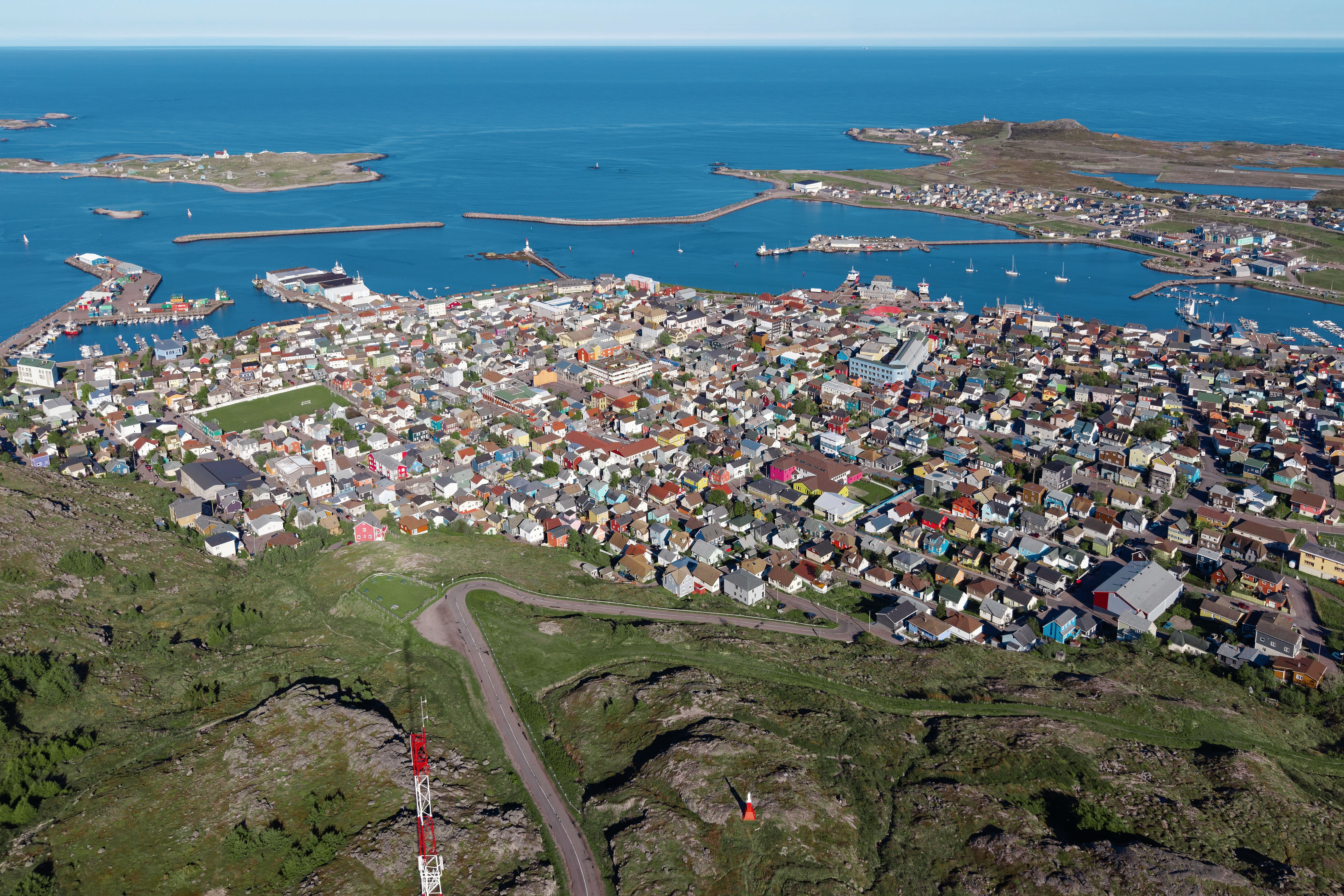
Quick answer: For a good introduction to Saint Pierre and Miquelon, explore Saint-Pierre’s harbour town and its L’Arche Museum and Archives, take the seasonal boat to Île aux Marins for fishing history, and choose a coastal walk such as Anse à Henry or the Cormorandière valley. Then give Miquelon-Langlade at least a dedicated day or two for its nature centre, Cap de Miquelon, the Grand Barachois lagoon and the remarkable isthmus connecting Miquelon and Langlade.
This small French overseas collectivity lies just south of Newfoundland, Canada, and is distinguished by its French language, maritime culture, harsh North Atlantic conditions and histories of fishing and settlement. Saint-Pierre’s colourful town streets are not the same experience as Miquelon’s large coastal wetlands and trails. The tourism authority advises allowing real time for the bigger island rather than assuming every place can be reached between two short ferry stops.
Outdoor conditions govern the itinerary. Wind, fog, temperature, ferry schedules and seasonal museum openings can change quickly, and some wildlife habitats need special respect. Boats connect Saint-Pierre with Miquelon and Langlade, and a separate seasonal shuttle serves Île aux Marins. The official 2026 ferry timetable website explicitly warns that published schedules can change. Select ten places to learn about—not ten boxes to tick before the next sailing.
eduKate · World heritage and learning
Choose a reading route through Saint Pierre and Miquelon
Coastal history, nature interpretation and the island-hopping decisions that shape a visit.
ROUTE 1 · PLACES 1–3
Saint-Pierre’s port history and shorter walking routes
Follow the places, then use Next for more.
ROUTE 2 · PLACES 4–6
Miquelon village, ecology and high coast
Follow the places, then use Next for more.
ROUTE 3 · PLACES 7–10
Miquelon-Langlade tombolo and protected wetlands
Follow the places, then use Next for more.
Choose your ten places
Some places are short town stops, while others require a boat, a guide or a substantial walk. The ten selections are a comparison rather than one continuous day tour.
| Place | What it offers |
|---|---|
| 1. Saint-Pierre harbour and historic town | Saint-Pierre is the archipelago’s main urban centre, developed around a protected cove that attracted fishing and trade. |
| 2. L’Arche Museum and Archives, Saint-Pierre | L’Arche is an important place for learning the history of Saint Pierre and Miquelon through organised museum exhibitions and archival collections. |
| 3. Île aux Marins fishing heritage island | Île aux Marins lies a short boat journey from Saint-Pierre and preserves the traces of a former fishing community, including a church, school, houses, cemetery and shoreline work areas. |
| 4. Anse à Henry coastal walking route, Saint-Pierre | Anse à Henry is a marked coastal walking route offering a compact introduction to the island’s heath, cliffs and sea. |
| 5. Cormorandière valley and Saint-Pierre’s natural landscapes | The Cormorandière valley is among the walking areas recommended by the territorial tourism service for its scenery, flora and fauna. |
| 6. Miquelon village and the House of Nature and Environment | Miquelon village provides an introduction to the larger island’s living community, which has ties to Acadian history and maritime livelihoods. |
| 7. Cap de Miquelon walking landscape | The Cap de Miquelon offers some of the region’s most dramatic high coastal scenery, with grassy slopes, sea cliffs and opportunities to observe wildlife. |
| 8. Grand Barachois lagoon and bird habitats | Grand Barachois is an important lagoon environment within the Miquelon-Langlade area, noted for shorebirds, seals and other wildlife. |
| 9. The Miquelon–Langlade isthmus (La Dune) | The broad sandy isthmus connecting the Miquelon and Langlade landmasses is one of the archipelago’s most distinctive geographical forms. |
| 10. Langlade and Anse à Dinand nature walk | Langlade has a more rural and expansive character than Saint-Pierre, with forest and meadow environments linked to the wider isthmus system. |
1. Saint-Pierre harbour and historic town
Why this place deserves time. Saint-Pierre is the archipelago’s main urban centre, developed around a protected cove that attracted fishing and trade. Colourful houses, busy quays, small shops and cultural institutions reflect a community shaped by maritime work and its relationship to Newfoundland and metropolitan France. A thoughtful visitor appreciates a living French town in the North Atlantic rather than expecting a Caribbean island or a recreated nineteenth-century fishing village.
What to notice. Observe how the harbour, streets, working piers and sheltered coves relate to one another. Look for houses adapted to wind and cold, while distinguishing authentic local construction from romanticised descriptions of bright colours. Markets, bakeries and public spaces are part of contemporary local life and can help illustrate connections with France. Busy docks remain workplaces even when a ferry or fishing boat provides an attractive photograph.
The learning question. Trace the journey of a fishing catch from a vessel to a processing or sales point and ask how seasonal weather affects the supply chain. Compare the coastal town’s layout with a map of nearby Newfoundland to understand why international connections matter. Research the history of cod fishing without claiming that present-day economic conditions are identical to those of earlier generations.
Access and planning
Start at the local tourist information centre for updated maps, open museums and seasonal tour arrangements. Respect active commercial areas, private homes and vessel movements. Coastal wind can make short walks colder than the air temperature suggests. Allow room in a first day for weather and arrival arrangements rather than planning an immediate long offshore outing.
2. L’Arche Museum and Archives, Saint-Pierre
Why this place deserves time. L’Arche is an important place for learning the history of Saint Pierre and Miquelon through organised museum exhibitions and archival collections. The territory’s tourism authority explains that the institution addresses both major historical events and everyday stories, including material related to the former guillotine. It offers context for a coastal walk because it helps visitors distinguish the experiences of fishing families, administrative authorities and successive communities from a broad claim that this is simply a picturesque French island.
What to notice. Observe how the museum combines objects, photographs, written documents and designed exhibits to communicate different periods. An historic object may be visually striking, but its provenance and the way it is described matter more than its shock value. Ask which stories are documented by letters or records and which rely on local memory. Museums may change exhibitions, so a guidebook’s description does not guarantee that every object is currently on view.
The learning question. Choose one archive item and ask what fact can confidently be learned from it, what broader context is required and what remains unknown. A single document cannot represent every member of a community. Compare this with what the harbour itself can show directly. A useful exercise is to create a modest timeline of settlement, fishing and administrative change using well-sourced dates.
Access and planning
Check L’Arche’s current hours, ticketing, exhibition programme and photography policies with the museum. Some programmes may be event-based. Take time for serious interpretation rather than rushing through before a ferry. Respect conservation rules and allow younger visitors guidance with difficult historic material.
3. Île aux Marins fishing heritage island
Why this place deserves time. Île aux Marins lies a short boat journey from Saint-Pierre and preserves the traces of a former fishing community, including a church, school, houses, cemetery and shoreline work areas. Tourism Saint Pierre and Miquelon explains that regular settlement ended in the twentieth century and that the island is especially animated by heritage visits during summer. It is not an amusement park or a place where time literally stopped; the surviving buildings tell the story of hard coastal livelihoods and community organisation.
What to notice. From the visitor paths, compare the former school and church with the landing place and working shoreline. Notice the relationship between pebble banks, weather exposure and small buildings. Look for explanations of drying or handling fish and other historical activities rather than assuming every object belongs to a single era. Respect cemetery spaces and any private or protected structures. Strong wind can change the experience of even a short walk.
The learning question. Ask what a remote fishing settlement needs beyond boats: schooling, worship, drinking water, repairs and winter supplies. Draw a map linking the historic wharf to the village’s shared facilities. The museum or local guide can help explain why families eventually shifted away from permanent residence; avoid inventing a simple cause from the quietness observed on a summer visit.
Access and planning
The tourism authority describes a short crossing of roughly ten to fifteen minutes, but seasonal departures and guided visits must be checked for the actual date. In October, do not assume the summer school museum and church visitor programme is still operating. Bring suitable outerwear, confirm your return passage and keep clear of fragile structures.
4. Anse à Henry coastal walking route, Saint-Pierre
Why this place deserves time. Anse à Henry is a marked coastal walking route offering a compact introduction to the island’s heath, cliffs and sea. Tourism Saint Pierre and Miquelon describes it as an easy trail of approximately 4.8 kilometres, typically requiring about two hours, with yellow and green markers. The walk can be an accessible nature-learning alternative to a more demanding island expedition, though official difficulty ratings are not guarantees that wet rock or strong wind will suit every visitor.
What to notice. Follow the signed path and compare exposed vegetation with more sheltered inland patches. Observe coastline forms and look for birds from a distance without approaching nests. The official guide warns that another route branches toward Cap au Diable, so correct trail identification matters. Changes in visibility or slippery footing can turn a modest walk into a poor choice on certain days.
The learning question. Draw a route sketch using the marker colours and a map, noting where different footpaths diverge. The task shows why navigation demands more than a compass direction or a straight-line distance. Ask how coastal vegetation responds to salt, wind and thin soils. A well-documented field note records exact conditions rather than assuming the same view is available throughout the year.
Access and planning
Verify the latest local route and weather notices before setting off. Wear suitable footwear, carry water and use wind protection. Respect marked paths and avoid cliff edges. Do not continue onto Cap au Diable accidentally when following a branch. An easy-rating walk is still optional if conditions are unsafe.
5. Cormorandière valley and Saint-Pierre’s natural landscapes
Why this place deserves time. The Cormorandière valley is among the walking areas recommended by the territorial tourism service for its scenery, flora and fauna. It is a useful counterpoint to built heritage in Saint-Pierre, highlighting the natural processes and climatic conditions that shape a subarctic maritime environment. A short valley walk can introduce the relationship between wetland, grass, rock and coastal topography without needing to book a major charter expedition.
What to notice. Notice vegetation transitions along the route, areas of standing water and how a valley channels wind or runoff. Bird life can be observed quietly, but neither specific species nor a clear panorama are guaranteed. The region’s scenic value should not tempt walkers beyond a maintained path. What looks like firm low vegetation may conceal boggy ground, and cliffs or steep slopes deserve caution.
The learning question. Ask how a valley’s form influences soil moisture, plant communities and the movement of water after rain. Compare a map’s contours with the actual length and steepness of the path. A scientific account benefits from descriptions of precipitation, wind and vegetation, not speculation about rare species based on a fleeting sighting.
Access and planning
The Nature Interpretation Centre describes Cormorandière among its guided Miquelon activities too, so verify the exact outing’s location and route rather than assuming similarly named features are interchangeable. Use the current tourism office hiking map, confirm trail access and take appropriate weather equipment. Guided environmental walks may be preferable for learning species names and avoiding boggy or restricted areas.
6. Miquelon village and the House of Nature and Environment
Why this place deserves time. Miquelon village provides an introduction to the larger island’s living community, which has ties to Acadian history and maritime livelihoods. Its House of Nature and Environment, also called the Nature Interpretation Centre, explains local habitats through exhibits and educational activities. The tourism authority identifies guided ecowalks covering the isthmus, Grand Barachois and Cap de Miquelon. Beginning here can greatly improve a nature-focused visit because it supplies local context before walkers enter sensitive areas.
What to notice. Compare a small coastal village’s layout with Saint-Pierre’s larger harbour town. At the interpretation centre, examine how exhibits distinguish bogs, shorebirds, forest and coastal ecosystems. Ask why the landscape around Miquelon supports different wildlife and agriculture from Saint-Pierre’s more densely built port. The institution offers a good place to understand the ethical limits of wildlife observation.
The learning question. Pick one bird, habitat or tidal process described in the centre and ask what makes it distinctive. A poster gives a useful introduction, while a guided field visit can test whether its characteristics are visible in nature. Learn the difference between a biodiversity observation and a population trend that needs repeated scientific research.
Access and planning
The tourism authority describes year-round centre operation with different weekly schedules depending on the season, but check present opening hours. Local guided ecowalks can last several hours and require bookings or appropriate fitness. Secure ferry or flight connections to Miquelon in advance rather than treating it as a spontaneous short detour from Saint-Pierre.
7. Cap de Miquelon walking landscape
Why this place deserves time. The Cap de Miquelon offers some of the region’s most dramatic high coastal scenery, with grassy slopes, sea cliffs and opportunities to observe wildlife. The local nature interpretation service includes a Cap outing in its programme. The landscape deserves respect because an attractive viewpoint is still exposed to wind, rapidly changing visibility and uneven walking surfaces. Its cultural significance also includes the ways local people navigate and work around a coast with limited shelter.
What to notice. From a currently open trail, compare inland meadows with the exposed ocean side. If deer or marine mammals are visible, observe them at a distance; sightings should not be promised. Look for changes in plant density along different slopes and consider how weather affects the view. Stay well back from rock edges and never step onto unstable ground for photographs.
The learning question. Draw an elevation cross-section and ask how a headland creates different conditions on windward and sheltered sides. A map of the cape also demonstrates why a loop walk can be demanding despite appearing compact. Connect physical geography with seafaring questions: how do sailors identify a headland in fog or changing light?
Access and planning
The nature centre’s official guide lists a roughly three-and-a-half-hour Cap walk among its guided excursions; times are indicative and may change. Check current routes, permissions and weather, and consider a local guide. Exposed cliff walks are inappropriate in strong wind or thick fog. Protect vegetation by remaining on marked paths.
8. Grand Barachois lagoon and bird habitats
Why this place deserves time. Grand Barachois is an important lagoon environment within the Miquelon-Langlade area, noted for shorebirds, seals and other wildlife. Its appeal lies in understanding a protected coastal wetland rather than guaranteeing close contact with animals. The nature interpretation service lists a guided Grand Barachois excursion, which helps visitors observe habitats without crossing fragile mud or dune environments. This is a living ecosystem influenced by tides and seasonal changes.
What to notice. From a permitted viewpoint, compare lagoon water with surrounding low dunes, shore and vegetation. Use binoculars for birds or seals and never approach resting or breeding animals. Wet or sandy ground can be fragile, and the absence of a visible barrier is not proof of public access. Watch how light and wind change the lagoon’s appearance, but do not infer the water’s ecological health from colour alone.
The learning question. Ask how a lagoon exchanges water with the sea and why sediment, salinity and tides matter for different organisms. Compare this with an open ocean beach near Saint-Pierre. A suitable field journal records the approximate condition and time of observation and asks which species identifications require expert confirmation.
Access and planning
Check conservation restrictions and book a qualified local nature guide when appropriate. The official guided activity is advertised as several hours, so it should not be squeezed into a quick ferry layover. Remain away from wildlife and nesting places, carry weather protection and do not attempt crossing tidal channels on foot.
9. The Miquelon–Langlade isthmus (La Dune)
Why this place deserves time. The broad sandy isthmus connecting the Miquelon and Langlade landmasses is one of the archipelago’s most distinctive geographical forms. Tourism Saint Pierre and Miquelon describes it as a tombolo, a sediment-built barrier connecting the two areas, with protected sections under the Conservatoire du littoral. It helps explain how waves, sand transport and wind shape a landscape that also supports wildlife and the movement of people across a relatively narrow land link.
What to notice. Observe sand ridges, dune vegetation and the contrasting shores where lawful viewpoints permit. Despite looking open, dune habitats can be fragile and protected. A strand of sand is not necessarily a convenient beach crossing: water, soft ground, tides and weather can make unsupported walking hazardous. The breadth and position of the isthmus are better understood with a map and guide than from a single aerial photograph.
The learning question. Draw a simple map showing the two landmasses and the sediment connection. Ask which processes might move sand or alter the dunes over long periods. Compare a tombolo with the rockier coast of Cap de Miquelon. This is an opportunity to distinguish gradual geomorphology from short-term beach changes after individual storms.
Access and planning
The nature centre offers a long guided isthmus outing, listed around five hours; use current conditions to decide whether it suits the group. Protected areas need special attention to footpath rules, grazing or wildlife restrictions. Never assume driving onto dunes or camping is allowed. The safest and most educational choice may be a guided viewpoint rather than a full crossing.
10. Langlade and Anse à Dinand nature walk
Why this place deserves time. Langlade has a more rural and expansive character than Saint-Pierre, with forest and meadow environments linked to the wider isthmus system. The official tourism guide recommends Anse à Dinand for a walk through bog, subarctic meadow and woodland, with broad views of Miquelon-Langlade. The value comes from seeing habitats change over a modest route rather than relying on a single famous rock formation.
What to notice. Notice how water availability and exposure alter vegetation on either side of a path. Look for signs of coastal birds or other wildlife without disturbing them. The same area can feel different in mist, wind and sunshine, making sensible clothing and route choice essential. A trail that passes through a bog requires discipline: walking off-route may damage peat or expose visitors to unstable footing.
The learning question. Make an observation chart comparing wetland, meadow and woodland in the same region. Which plants are common in each, and which descriptions require authoritative identification? The exercise illustrates the environmental range that can exist on a small archipelago. Follow up by comparing the habitats with the protected lagoon at Grand Barachois.
Access and planning
Consult the official Saint Pierre and Miquelon nature guide and latest ferry schedules to Langlade. Some island areas have limited transport, no regular visitor services and highly variable weather. Use a trained local guide for unfamiliar ground and never enter private farmland or protected wetland without authorisation.
Plan a thoughtful Saint Pierre and Miquelon journey
Decide between a Saint-Pierre day and a Miquelon-Langlade excursion. Saint-Pierre’s town, L’Arche and Anse à Henry are comparatively close. Miquelon village, Cap de Miquelon, Grand Barachois and the isthmus need another base or a well-timed long outing. A nature guide is often more useful than an ambitious self-guided trail plan.
Check the current ferry calendar. SPM Ferries publishes route-specific 2026 schedules for Saint-Pierre, Miquelon, Langlade and Fortune, Newfoundland, and warns that departures may change. Île aux Marins has a separate seasonal small-boat service. Plan each crossing individually and leave time for weather delays.
Distinguish easy trails from guaranteed safe conditions. Anse à Henry is rated easy by the tourism authority but still demands suitable footwear, wind protection and correct branch choices. Longer Cap and isthmus trails should be assessed for fitness and weather, ideally with a local guide.
Protect protected habitats and cultural remnants. Grand Barachois, wetlands, dunes and former fishing settlements deserve different kinds of care. Observe wildlife quietly, respect closed land and do not remove materials from historic buildings or natural sites.
Confirm immigration for every leg. Saint Pierre and Miquelon is French territory, not part of Canada despite its location near Newfoundland. An itinerary passing through Canada can require separate Canadian transit or entry documentation as well as French overseas territory requirements.
Recognise local community life. The port, modern restaurants, ferry workers, nature interpreters and agricultural activities are as meaningful as the historic fishery. Avoid describing inhabited areas as completely untouched or their heritage as frozen in time.
Frequently asked questions
Is Saint Pierre and Miquelon part of Canada?
No. It is a French overseas collectivity situated near Newfoundland. Travellers using Canada as a transit point must consider the applicable entry rules for both jurisdictions.
Can I visit Île aux Marins all year?
The island can be accessible subject to boats and conditions, but heritage visits and shuttle services are strongly seasonal. Confirm actual departures and museum opening for your dates.
What is the Miquelon–Langlade isthmus?
It is a sediment-built tombolo linking Miquelon and Langlade. Some areas are protected habitats and should be visited via permitted routes.
Do I need to stay overnight on Miquelon?
It is not always essential, but the tourism office recommends allowing substantial time. For multiple nature walks or weather contingencies, overnight accommodation is usually more realistic than a brief connection.
Can I approach seals at Grand Barachois?
Wildlife should be observed from a respectful distance, preferably with a trained local guide. Avoid disturbing resting, breeding or feeding animals.
Are all walking routes suitable for families?
No. Routes vary from easier marked coastal paths to long multi-hour walks across exposed or wet ground. Check current conditions, route difficulty and each walker’s ability.
Build understanding through evidence
A good Saint Pierre and Miquelon field study compares three subjects: harbour development and fishing history on Saint-Pierre, subarctic habitats around Miquelon, and the sediment processes creating the connecting isthmus. A map, a museum display and a naturalist’s interpretation each provide different evidence. Being explicit about what is observed and what remains uncertain improves both a travel diary and the reader’s practical decisions.
For family learning, map a journey from Saint-Pierre’s harbour to the Miquelon–Langlade isthmus, then explain why a ferry, road transfer and guided walk take more time than a direct map line suggests. Making assumptions visible is also central to eduKate’s Secondary 1 Mathematics Tutor Clementi | Small Groups Tutorials.
Continue learning about Saint Pierre and Miquelon
Top 10 Things to Do When Visiting and Touring Saint Pierre and Miquelon · Top 10 Things to Learn When Visiting and Touring Saint Pierre and Miquelon · World Country Directory
Featured photograph: Saint-Pierre town and harbour, photograph by Quintin Soloviev, June 2026, CC BY 4.0, via Wikimedia Commons.

Sources and current information
Sources reviewed 18 October 2026 (Singapore time). Museum and historic descriptions do not establish seasonal opening or ferry availability for particular dates. The official 2026 ferry calendar explicitly warns that departures may change. Confirm tickets, safe routes, visitor permissions, weather and entry requirements directly.
- Tourism Saint Pierre and Miquelon — Ten beautiful sites
- Tourism Saint Pierre and Miquelon — exceptional islands
- Tourism Saint Pierre and Miquelon — Île aux Marins heritage
- Tourism Saint Pierre and Miquelon — Nature Interpretation Centre
- Tourism Saint Pierre and Miquelon — Anse à Henry walking route
- Tourism Saint Pierre and Miquelon — natural landscapes
- Saint Pierre and Miquelon — official 2026 ferry schedules
- Tourism Saint Pierre and Miquelon — international access
- Tourism Saint Pierre and Miquelon — cultural museums