
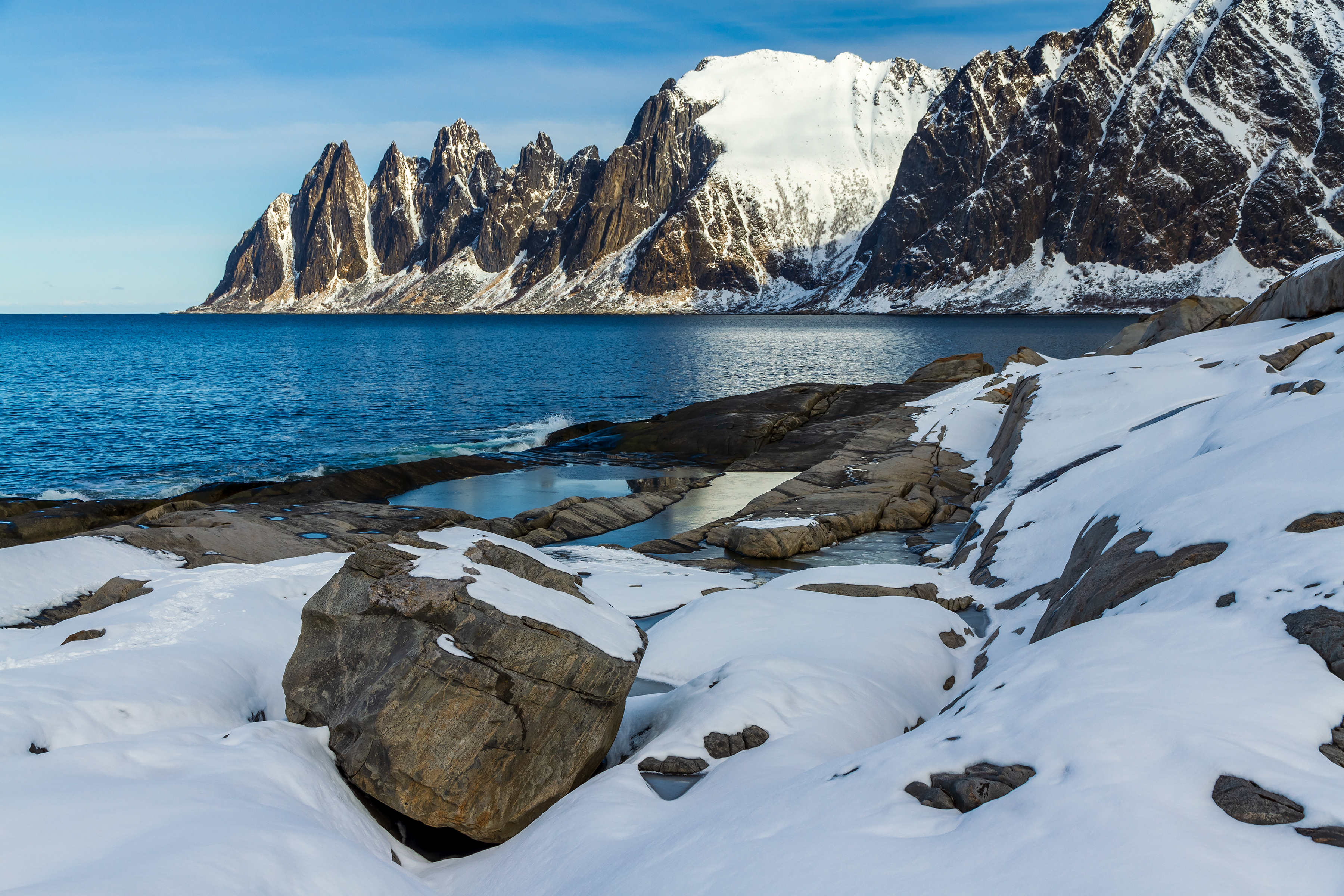
What are the best places to visit on Senja, Norway? Start with the famous Tungeneset walkway facing the Okshornan peaks, then enjoy the Bergsbotn viewing platform, Ersfjordstranda Beach, Husøy fishing village and Mefjordvær harbour. More rewarding places are Fjordgård for views of Segla, the forests of Ånderdalen National Park, the islands near Hamn, the villages and beaches around Skaland and Bøvær, and Gryllefjord at the western end of the Scenic Route. Together, these ten destinations make a practical introduction to Senja’s fjords, mountains, coast, community and wildlife.
Senja is one of Norway’s largest islands, in Troms north of the Arctic Circle, and is connected to the mainland by bridge via Finnsnes. The official Norwegian Scenic Route Senja is 102 kilometres between Botnhamn and Gryllefjord, not a guarantee that you can explore the island properly in two hours. For a first stay, three to five days gives you time to see the famous western views and a different, greener part of the island. Two days can be enjoyable when you choose your route carefully.
October 2026 travel planning: Scenic viewpoints, roads, ferry services, museum access and hiking conditions need to be checked for your actual travel dates. The Gryllefjord–Andenes ferry is seasonal, whereas the Botnhamn–Brensholmen route operates year-round subject to its current timetable and conditions. Some roadside toilets close after the summer season. This guide does not promise a ferry, a suitable mountain trail or a permanently open visitor facility.


Plan first: which part of Senja do you want to explore?
Senja’s dramatic outer coast is what attracts many visitors, but the island is large enough to offer several quite different holidays. Photographers gravitate towards the official viewpoints at Tungeneset and Bergsbotn. Travellers who enjoy local communities can stay longer in Husøy, Mefjordvær or Gryllefjord. Families may choose a scenic beach and a short accessible national-park trail. Fit and experienced hikers might plan for Segla, Hesten or Husfjellet, but should understand that a photographic route is not automatically a safe group outing. Someone who dislikes heights can see magnificent mountains from the road without climbing them.
The best planning method is to divide your time between the northern coast, the western fjords and the southern interior. The main scenic road winds through mountains and village roads that deserve careful driving. A 102-kilometre drive is not the same as a 102-kilometre day of sightseeing: walking, parking, breaks and weather multiply the time needed. Think of the list below as ten possible experiences from which you can make a sensible itinerary, not a circuit that every visitor should finish in numerical order.
Senja’s ten highlights at a glance
- 1. Tungeneset Boardwalk and Okshornan Mountains — Northwestern Senja, between Steinsfjord and Ersfjord
- 2. Bergsbotn Viewing Platform and Bergsfjorden — Western Senja above the village of Bergsbotn
- 3. Ersfjordstranda Beach and the Golden Service Building — Ersfjord, northern section of the Scenic Route Senja
- 4. Husøy Fishing Village and Island Community — Husøya, linked to northern Senja by road
- 5. Mefjordvær Harbour, Breakwater and Coastal Village — Northern Senja at the end of the Mefjordvær road
- 6. Fjordgård, Segla and the Hesten Viewpoint — Northern Senja near Fjordgård village
- 7. Ånderdalen National Park and Tranøybotn Trail — Southern and central Senja, inland forest and protected landscape
- 8. Hamn i Senja and the Bergsfjord Coastal Islands — Western Senja near Hamn and Bergsfjorden
- 9. Skaland, Bøvær Beach and the Husfjellet Landscape — Western Senja near Skaland and Bøvær
- 10. Gryllefjord Harbour and the Western Ferry Gateway — Western tip of Senja, end of the official Scenic Route
Each location includes practical advice and a learning perspective, so you can choose stops for their meaning as well as for their photographs. Some are easy managed viewpoints, while others involve working villages, protected parks or serious hikes. The distinction is essential. Treat a cliff trail, a beach and an inhabited fishing harbour differently, and check the exact conditions before setting out.
1. Tungeneset Boardwalk and Okshornan Mountains
Where: Northwestern Senja, between Steinsfjord and Ersfjord. Best for: Signature mountain views with a designed coastal walkway.
Tungeneset is an outstanding place to begin the Senja experience because a thoughtfully designed walkway brings visitors towards an extraordinary sight without requiring a mountain summit. From the promontory, the jagged peaks of Okshornan rise above the Norwegian Sea, appearing almost like a row of sharp teeth. Their dramatic outline explains why travellers sometimes call them the Devil’s Teeth. But the scene is more than a picturesque composition. It shows the contrast between extremely hard coastal rock, the Atlantic-facing shoreline and the limited strips of land on which roads and villages can fit. On a day with calm light, the entire headland seems sculptural. On a stormy day, the same coast reveals how demanding life beside the open sea can be.
The Norwegian Scenic Routes authority identifies Tungeneset as a wheelchair-accessible rest area with a larch walkway designed by Code arkitektur. The public facilities, however, have their own seasonal arrangements: official guidance places toilet opening broadly from early May to early October, and access or maintenance can still change. Do not confuse the existence of a walkway with a promise that the outer rock surfaces are safe in ice or high wind. Remain on permitted paths and keep well away from waves, wet rock and exposed edges. Families may spend an easy half-hour watching the mountains; photographers may need longer but should not monopolise narrow sections of the walkway. The most important travel decision is to visit only in conditions that are safe for your group.
At Tungeneset, try three questions. First, how does the shape of the land explain where the road has been placed? Second, why does a designed walkway change how visitors interact with a fragile coast? Third, which parts of the view are fixed over geological time, and which change with tide, weather and season? The structure is an interesting example of architecture working with, rather than hiding, the landscape. You can admire Okshornan without attempting to climb any peak. A safe, considered viewpoint visit is a complete experience in its own right.
How to include it: Combine with Ersfjordstranda, Mefjordvær or an organised scenic drive. Do not treat the rock platform as a free-climbing playground.
Back to all ten places · Next location
2. Bergsbotn Viewing Platform and Bergsfjorden
Where: Western Senja above the village of Bergsbotn. Best for: Fjord panoramas, architecture and short scenic pauses.
The Bergsbotn platform is one of Senja’s most effective examples of how a small structure can help people appreciate a very large landscape. Extending out from the mountainside above Bergsfjorden, the platform frames a panorama of layered peaks, the narrow village below and the many shapes of the fjord. The official Norwegian Scenic Routes programme describes the structure as 44 metres long. That number helps convey its unusual form, but the reason to visit is the perspective: a winding coastal road, houses and shorelines suddenly fit together as one geographic system. What seemed hidden by curves at road level becomes clear from above.
This is a managed roadside viewpoint, not an invitation to scramble across the surrounding hillside. The authority lists the facility as wheelchair accessible, but visitors should still check current maintenance and weather before relying on the access. In strong wind, on icy surfaces or when snow accumulates, a short view may be more appropriate than waiting for an ideal photograph. Park only where permitted and avoid blocking the road. The site can be busy in summer, so share the platform, keep tripods from creating bottlenecks and be considerate of people using mobility aids. Bring a windproof layer even if the day was warm in a sheltered valley.
Bergsbotn offers a wonderfully direct lesson in reading a landscape. Identify the fjord, the settlement, the road and the mountains, then ask why each is where it is. Why do homes gather on small areas of flatter land? How does a fjord offer shelter and access but also narrow the space for building? Why might views from a platform be more informative than views from a moving vehicle? Travellers can also compare a photo taken in summer with one in winter, noticing the difference between geographic structure and temporary conditions. A few minutes of careful observation can be more rewarding than a rushed stop at five other viewpoints.
How to include it: Pair with a western Senja day involving Bøvær, Skaland or a modest village walk. Allow parking and walking time.
Back to all ten places · Next location
3. Ersfjordstranda Beach and the Golden Service Building
Where: Ersfjord, northern section of the Scenic Route Senja. Best for: White sand, sheltered fjord scenery and architectural design.
Ersfjordstranda is a sandy beach that can look almost tropical in photographs, until the surrounding northern Norwegian mountains remind you where you are. White, fine-grained sand meets clear-looking fjord water, backed by steep rock walls. The site is also known for an angular gold-coloured service building created as part of the Scenic Routes architectural programme. It is a delightful example of how a practical facility can become a distinctive landmark when architects respond imaginatively to a setting. Together, beach, mountains and modern design make the stop different from Senja’s cliff viewpoints.
The beach is suitable for a quiet walk, photography or a picnic in appropriate conditions, but it is not an automatically safe swimming destination. Arctic water can be cold even on a bright summer day; currents, waves and air temperature matter. Check posted guidance and do not assume lifeguards are present. The Scenic Routes authority lists the rest area as partially wheelchair accessible and says the toilet facilities are generally open from early May to early October. Out-of-season travel may still offer the landscape but not the services. Avoid disturbing dune vegetation and leave rubbish in appropriate facilities. Use designated parking rather than the beach or a passing place on the road.
This stop can be used to compare perception with evidence. The colour of water does not establish its temperature, and a photograph cannot tell you whether it is safe to swim. The sand also raises questions about waves, sediment and the way local geography shapes a coastline. Notice how sheltered parts of the fjord contrast with the more exposed Tungeneset headland. Then consider the golden building: why would designers give a utility structure such a strong visual identity? Its appeal comes not from hiding its function but from celebrating it as part of a public landscape.
How to include it: Pair Ersfjordstranda with Tungeneset and Mefjordvær during a northwestern scenic-drive day.
Back to all ten places · Next location
4. Husøy Fishing Village and Island Community
Where: Husøya, linked to northern Senja by road. Best for: Living fishing culture and adaptations to harsh weather.
Husøy is among the most memorable places on Senja precisely because it is a working village rather than a nature reserve. The settlement sits on a small island in a fjord, reached by road from larger Senja. Its houses, boats and harbour fit tightly into a dramatic landscape of steep mountains and exposed water. Local visitor information describes a curious adaptation to winter storms: houses have sometimes been anchored with cables to help withstand severe winds. This detail is a better introduction to the village than any exaggerated claim that residents live at the edge of the world. It shows how engineering, local knowledge and community choices address the physical conditions of daily life.
Take the access road slowly and consider whether there is suitable public parking before entering the narrow village streets. Respect residents, private steps, gardens, fish-processing areas and working quays. The village is not an open-air museum, and the presence of scenic viewpoints does not create a right to trespass for photographs. A meal at a local establishment can be a good way to support the economy when it is open, but booking and seasonal service need checking. If the weather is poor or the road is difficult, prioritise safe driving over a particular photograph. The experience is most rewarding when you arrive without an aggressive schedule.
Husøy helps visitors understand why tourism photographs can leave out an important part of the story. A pretty village is also a place of work, housing and adaptation. Imagine what fishermen, children, emergency services and delivery drivers need from the same roads tourists use. Ask what problems wind can cause for buildings and boats, and why communities may prefer a sheltered harbour or a particular building form. This kind of observation gives visitors a more respectful and accurate understanding of Senja than referring to its small settlements only as hidden gems.
How to include it: Treat Husøy as a deliberate detour from the main scenic road, not a five-minute stop squeezed into an already crowded route.
Back to all ten places · Next location
5. Mefjordvær Harbour, Breakwater and Coastal Village
Where: Northern Senja at the end of the Mefjordvær road. Best for: Old fishing village, shoreline walking and visitor-friendly rest stop.
Mefjordvær occupies a sheltered position between the Norwegian Sea and Senja’s high mountains, making it a particularly attractive place to slow down. It has a long fishing-village identity, and its harbour and breakwater demonstrate the practical importance of safe water access. A visit here offers a different scale from the dramatic panoramas at Bergsbotn. You can notice the boats, community buildings, sea defence and residential streets close up. Norwegian Scenic Routes has developed a modern rest area by the breakwater with a distinctive toilet building and shelter, bringing contemporary public design into a historic working setting.
The official Scenic Routes page describes the Mefjordvær viewpoint as wheelchair accessible and notes public facilities including a toilet open throughout the year and a separate disposal facility for motorhome waste. Availability can still be affected by maintenance or weather, so verify when necessary. A breakwater walk can offer a close sense of the sea, but use judgement in strong wind or heavy swell and obey any restrictions. Do not block harbour work or approach vessels without permission. If you are travelling in a campervan, use the correct sanitation arrangements rather than assuming ordinary roadside toilets can accept tank disposal. The village deserves patience and consideration.
The built environment at Mefjordvær is a lesson in the relationship between natural shelter and human effort. A fjord provides some protection, but a breakwater changes the way waves and boats interact with a harbour. Why do residents spend money on such structures? What happens when larger modern fishing boats need different facilities from earlier vessels? Visitors can also compare architecture intended for tourism with infrastructure built for daily life. Both share the same coast, but the needs behind them differ. The result is a place where natural beauty and community history reinforce one another.
How to include it: Include Mefjordvær on a day with Tungeneset and Ersfjordstranda, leaving time for an unhurried harbour walk.
Back to all ten places · Next location
6. Fjordgård, Segla and the Hesten Viewpoint
Where: Northern Senja near Fjordgård village. Best for: Iconic mountain scenery with realistic hiking choices.
Few Senja photographs are as recognisable as the steep dark profile of Segla rising above a fjord. It is tempting to think the best trip is to climb straight to the summit, but the most famous view of Segla itself is often taken from the neighbouring Hesten route. Fjordgård is the local starting area for these mountain experiences. The geography is spectacular: narrow ridges, steep walls and deep water turn even a small change in position into a dramatic visual difference. The fact that two routes show different views is also an excellent reminder that a photograph does not reveal how difficult it was to reach the point where it was taken.
Both Segla and Hesten are mountain hikes, not family promenades. Routes vary in exposure, steepness and trail conditions, and the famous photographic spots can be dangerously close to drop-offs. Consult up-to-date local trail guidance, check the day’s weather, allow sufficient daylight and take proper equipment. Do not use a social-media photograph to justify sitting on an unprotected cliff edge. If you are inexperienced or the forecast is poor, choose a roadside or lower-altitude view and explore the village respectfully instead. Trails may be congested in peak periods, so share narrow sections, stay off fragile vegetation and observe parking rules.
Segla and Hesten make a useful lesson in perspective. A mountain that looks impossibly sharp from one angle may have a different profile from another. In photography, the chosen viewpoint can make an object appear larger, more isolated or more dangerous than it actually is; in this case, the terrain truly can be steep, but each image still shows only part of the reality. When planning a hike, use maps, elevation profiles and current safety information rather than visual impression alone. Choosing not to attempt a summit can be the most intelligent decision a group makes on the entire island.
How to include it: Give Fjordgård and any serious hike a separate good-weather day. Do not combine a summit outing with numerous distant road stops.
Back to all ten places · Next location
7. Ånderdalen National Park and Tranøybotn Trail
Where: Southern and central Senja, inland forest and protected landscape. Best for: Pine forest, gentle trails and a different side of Senja.
The cliffs along Senja’s outer coast are rightly famous, yet Ånderdalen National Park reveals a contrasting island environment of old-growth pine forest, birch woodland, rivers, lakes, bogs and mountain slopes. It is an important reminder that Senja is not simply a strip of dramatic coastal road. The park was established to protect distinctive forest and wild landscapes, and its southern entrance near Tranøybotn offers a practical introduction for visitors who do not want a challenging ridge hike. The shift from exposed Atlantic headlands to sheltered forest can be one of the most memorable transitions of a longer stay.
Visit Senja describes a universally designed entry trail near Tranøybotn that passes the Vardnesmyra nature reserve and reaches the edge of the national park in about two kilometres. That is the accessible introductory route, not a promise that the entire park is step-free or easy. Check current trail conditions, facilities and seasonal wildlife protection. Longer paths through the park may be rough, wet or remote and require more experience. Leave plants, stones and wildlife undisturbed, stay on permitted routes and take all rubbish out. For families or visitors who prefer a gentle pace, the entry path may provide ample scenery without any pressure to push deeper into the wilderness.
An inland nature day offers a richer view of Senja’s ecology. How does the density of tree cover affect wind and light? Why do bogs and wet soils require careful footpath design? Which parts of a forest look old, and what evidence would a scientist need to estimate their age or ecological value? These questions invite observation without requiring wildlife to appear on command. A protected landscape exists not to guarantee tourist sightings but to conserve living systems over time. Enjoying a short marked route respectfully contributes to that purpose.
How to include it: Use Ånderdalen for a separate southern-island half-day or day; avoid treating its forest trails as a quick detour from the far western coast.
Back to all ten places · Next location
8. Hamn i Senja and the Bergsfjord Coastal Islands
Where: Western Senja near Hamn and Bergsfjorden. Best for: Harbour history, island scenery and guided sea activities.
Hamn i Senja is both a historic harbour setting and a modern accommodation and activity base. The old fishing community dates back to the nineteenth century, while the present-day facilities provide lodging, food and organised outdoor experiences. This combination is particularly useful for visitors who want to understand how a northern Norwegian harbour can change economic roles without losing its connection to the sea. Nearby Bergsfjorden contains islands, skerries and rugged shorelines that are sometimes best appreciated from an authorised viewpoint or guided boat. The atmosphere differs from the exposed northern cape, offering a wider panorama of inlets and small landforms.
You do not need to stay at a resort to appreciate Senja’s wider coastline, but never assume that guest facilities, boat moorings or private accommodation grounds are public. If booking a guided outing, check its suitability for children, marine conditions, duration, clothing requirements and cancellation rules. Kayaking and RIB experiences require different levels of fitness and comfort; a relaxed fjord cruise may be preferable for some groups. Do not promise a whale or sea eagle sighting. If you prefer not to go on the water, use permitted roads and viewpoints for an equally legitimate landscape experience.
This area invites questions about economic and environmental change. A fishing harbour may later support accommodation, guided trips and dining, yet still depend on healthy marine ecosystems and transport connections. What makes a harbour sheltered? How do the many islands alter waves or navigational routes? Why might one coastline support a village while another is too exposed? Compare the answers with Husøy or Mefjordvær to see how similar geography can produce different settlement patterns. A coherent trip turns such comparisons into a story rather than a collection of unrelated photographs.
How to include it: Pair Hamn with Bergsbotn and Skaland-area attractions. Book sea outings separately from a long scenic-drive timetable.
Back to all ten places · Next location
9. Skaland, Bøvær Beach and the Husfjellet Landscape
Where: Western Senja near Skaland and Bøvær. Best for: Fishing communities, sandy beach and a moderate mountain option.
Around Skaland and Bøvær, Senja offers a mix of village life, sand and mountain views that makes this a particularly rewarding area for travellers who dislike rushing. Bøvær is one of the coastal detours mentioned by Norway’s Scenic Routes authority, and the beach gives a softer counterpoint to the sharp peaks around Bergsfjorden. Skaland is also associated with the Husfjellet walk, often described as a more approachable mountain outing than some of Senja’s exposed iconic peaks. Approachable does not mean effortless, however: even a moderate hill can be demanding in poor weather or for someone unfamiliar with hiking.
Choose either a relaxed village-and-beach visit or a properly planned hike, rather than automatically both. For a beach day, treat water as cold until current conditions establish otherwise and check whether swimming is appropriate. For Husfjellet, consult the latest route information, evaluate elevation gain and trail surface, and avoid exposed sections in strong wind or poor visibility. There are no prizes for completing a summit with a tired child. If you stop in a working community, use appropriate parking, support businesses when open and respect private houses and farm access. Small villages cannot absorb unlimited roadside parking without inconvenience.
This area is useful for comparing how people use different kinds of landscape. Beaches can be gathering places and habitats; villages are centres of work and community; mountains offer routes for recreation but also shape wind and weather. From an authorised viewpoint, identify which surfaces are sand, rock and vegetation. Then ask why a road or settlement follows a particular shoreline. These questions help explain Senja far more accurately than describing every view as simply dramatic.
How to include it: Group Skaland, Bøvær and a realistic Husfjellet plan together. Save strenuous hikes for their own good-weather day.
Back to all ten places · Next location
10. Gryllefjord Harbour and the Western Ferry Gateway
Where: Western tip of Senja, end of the official Scenic Route. Best for: Fishing community, regional transport and unhurried fjord views.
Gryllefjord is a compact fishing village at the western end of Norway’s Scenic Route Senja. Tall mountains frame its harbour, and in summer the area becomes a gateway to Vesterålen through the Gryllefjord–Andenes ferry. But its relevance is not limited to a boat timetable. The village’s working waterfront, fishing accommodation and connections to inland Senja show how settlements can be both homes and transport nodes. When the weather is kind, a simple shoreline walk and meal can be a more enjoyable final stop than another hurried mountain climb.
The ferry to Andenes is a summer route, not a year-round service. Visit Senja’s transport guidance describes an operating period broadly from mid-May to late September, but exact dates, frequency and vehicle arrangements must be verified for your year. In popular periods the service can have long queues, and advance vehicle reservations are not necessarily available. Do not plan to arrive ten minutes before sailing and assume space on the boat. Outside the season, use the road connections instead. Even if no ferry is operating, Gryllefjord can still be visited for its working community and coastal setting, subject to local business hours and the day’s weather.
Transport turns geography into practical choices. From Gryllefjord, a line on the map to Andenes looks short; whether you can actually cross depends on a seasonal public service and weather. Compare this with the year-round Botnhamn–Brensholmen connection in northern Senja and the bridge to the mainland at Finnsnes. A traveller who understands those links can plan an entire northern Norway route more confidently. At the harbour, think about the balance between fishing, residents, seasonal visitors and infrastructure. That is the everyday logic of island life.
How to include it: Make Gryllefjord the destination of a western scenic day or the departure point for an independently confirmed summer ferry. Never treat it as a guaranteed year-round Andøya connection.
Three workable Senja itineraries: two days, four days and six days
Two days: a western-coast introduction
When you have only two days, stay in a practical part of northern or western Senja and concentrate on the Scenic Route. Use the first day for Tungeneset, Ersfjordstranda and either Mefjordvær or Husøy. On the second day, visit Bergsbotn, Skaland and Bøvær, perhaps continuing to Gryllefjord if the day’s driving is comfortable. Allow time for proper meals, photo stops and changes in the weather. If arriving from Tromsø, do not use a late ferry arrival as the starting signal for a rushed mountain hike. The best two-day plan is a selective one.
Do not add Segla, Hesten, Husfjellet and Ånderdalen simply because they appear in the top-ten list. A single serious hike can take a substantial part of a day, and southern Senja deserves its own journey. Two days is enough to enjoy the island, not enough to experience every landscape. A guide that pretends otherwise may be excellent for search rankings but poor advice for a real traveller.
Four days: northern viewpoints, villages, western fjords and forest
On day one, explore the northern road around Tungeneset, Ersfjordstranda and Mefjordvær. On day two, visit a working fishing community such as Husøy and spend time in a village rather than continuing straight through. On day three, head west for Bergsbotn, Hamn, Skaland and Bøvær, with Gryllefjord as an optional destination. On day four, choose a suitable Ånderdalen National Park entry walk or a single mountain outing if the entire group’s experience and weather support it. This brings together architecture, geology, history, wildlife and community without making the holiday feel like a race.
A central or southern base can be useful for Ånderdalen and mainland connections, whereas staying on the outer western coast reduces time spent returning to scenic viewpoints. Some visitors choose two accommodation bases; others prefer a single one and accept longer drives. The right choice depends on your willingness to move luggage, the season and whether an excursion involves an early departure. Keep a flexible indoor or town alternative in case of rain or mountain cloud.
Six days: slow travel and a weather buffer
With six days, you can enjoy a village overnight, a guided fjord excursion or a mountain hike while keeping the flexibility to rearrange plans. Set aside a full day for Ånderdalen’s forest and an inland landscape. Give another day to the western coastline and a suitable guided boat trip if you want to explore islands and marine habitats from the water. Keep at least one uncommitted day for weather and simple local pleasures such as café time, a short walk or an unexpected exhibition. The aim of a longer stay is not to find six more tasks, but to experience Senja’s rhythm.
How to reach Senja: bridge, ferries and the seasonal Andenes connection
You can drive onto Senja via the bridge at Finnsnes. Travellers from Tromsø and the Kvaløya area may use the Botnhamn–Brensholmen car ferry, a year-round route whose individual departures remain subject to timetable and weather. The west-side Gryllefjord–Andenes ferry provides a seasonal summer connection to Vesterålen. Visit Senja’s published transport guide describes it as operating broadly from mid-May into late September, with the exact end date and sailings needing confirmation in the current season. These ferries do not serve identical travel purposes, so check the correct harbour before making driving plans.
A combination of Senja and Vesterålen is very attractive because Norwegian Scenic Route Senja can connect with Scenic Route Andøya when the Gryllefjord–Andenes ferry runs. But outside its seasonal period, the journey involves going by road, often substantially farther than a map’s short sea line suggests. Do not promise the ferry at Easter or in late October merely because the official scenic-drive map draws a connection. In summer, queues can be long and advance vehicle reservations may not be offered; verify check-in rules and follow local staff instructions.
The main road within Senja includes narrow sections, twists and changing mountain weather. If travelling by public transport, start with Norway’s national journey planner Entur and regional provider information, then check the actual stop and service date. A timetable that works for residents may not enable a one-day tourist loop through remote villages. Cycling is possible along parts of the signed National Cycle Route 1, but it involves hills, weather, limited shoulders and traffic. Plan distances honestly rather than assuming a 102-kilometre scenic road is a casual family cycle ride.
Safety on Senja’s steep hikes and exposed roads
Senja has a spectrum of outdoor experiences, from managed viewing platforms to demanding alpine terrain. Do not apply the same safety assumptions to both. The Tungeneset boardwalk and Bergsbotn platform are designed for relatively easy sightseeing in suitable conditions; Segla, Hesten and Husfjellet require route planning, good footwear and weather judgement. Some mountain trails have steep drop-offs and can be dangerous in rain, ice or strong wind. Even when another traveller’s photograph makes a summit look easy, the photographer’s exact path may have required skill, fitness and safe conditions that are absent today.
Check local route guidance just before the hike, tell someone where you plan to go, carry suitable layers and supplies, and agree on a turnaround time. Take particular care with narrow roads and scenic roadside stopping. Pull into designated spaces rather than blocking oncoming traffic or residents’ driveways. In winter, snow, ice and short daylight make self-driving and hikes more demanding. Guided tours can be a sensible way to enjoy the region without having to make all the route and weather decisions yourself.
Coastal water and mountain views also require restraint. White sand can conceal cold water and fast weather changes; do not assume a beach is lifeguarded. Rock pools, docks and harbour breakwaters may be slippery or exposed to surge. Wildlife photography should never disturb nesting birds or marine mammals. Respect grazing animals, farm gates and protected woodland. The best view is the one you can enjoy safely and leave in good condition for the next person.
Where to stay: choosing a base by geography rather than hype
For a short scenic-drive break, a base near northern or western Senja makes sense because it reduces travel time between the famous fjord viewpoints. For a larger family trip, accommodation with easy access to road services may be more convenient than a very remote cabin. Gryllefjord can be a practical western base when planning a summer ferry connection, but if the ferry is not operating it may not serve as a transport shortcut. A stay near a fishing village may offer a more personal connection to Senja, provided you remember that these are residential communities rather than purpose-built holiday parks.
Look carefully at what the accommodation actually offers: kitchen facilities, parking, step-free access, winter-road access and proximity to the experiences you want. The phrase ‘sea view’ does not tell you how many hours it takes to reach Ånderdalen, and ‘near the Scenic Route’ does not establish that shops or restaurants are open every evening. When travelling in peak summer, book popular lodging earlier; in quieter months, verify that food and transport arrangements are realistic. A good overnight base should make your days simpler, not introduce a new daily drive.
Season by season: midnight sun, autumn colour and Arctic winter
Summer gives long daylight and the opportunity to experience the midnight sun around the northernmost parts of the country, although cloud still determines what you can actually see. It is a popular period for hiking, guided sea trips and beach walks. Late spring and autumn can bring beautiful light, but changeable weather and closures of seasonal toilets or visitor facilities need more attention. The northern lights may be possible in dark-season months with appropriate solar activity and clear skies; they are never guaranteed. A three-night itinerary should be designed around the landscapes themselves, not the promise of aurora photography.
Winter changes Senja profoundly. Snow can make mountains beautiful from safe roadside positions, while ice and limited light can turn a formerly straightforward trail into serious terrain. A visitor who is unfamiliar with winter driving or avalanche risk should seek local advice and suitable guided experiences. Do not imitate summer summit routes with winter equipment you do not know how to use. Families may find that a sheltered village stay, a short scenic outing and warm local meals produce a better holiday than trying to recreate a summer itinerary in freezing wind.
What Senja teaches about fjords, coasts and northern communities
Senja makes geographical explanations unusually visible. A fjord is more than a beautiful inlet: it shapes the route of roads, the location of communities and the degree of shelter offered to boats. Narrow strips of buildable land explain why villages can appear compressed between cliffs and sea. At Husøy, residents’ adaptation to wind is a practical engineering story. At Tungeneset and Bergsbotn, architectural interventions help visitors see the landscape while keeping their movement within managed areas. The island is a place where the interplay of physical geography and human decision-making is visible almost everywhere.
A simple way to learn is to separate observation, explanation and evidence. Observe the shape of a cliff; ask which geological processes could help explain it; then consult interpretation rather than inventing a confident age. Observe a fishing harbour; ask why boats gather there; then learn about local sea conditions and work. Observe a protected forest; ask what keeps it healthy; then read the national-park conservation guidance. A holiday remains relaxing when questions arise naturally rather than becoming an examination.
English–Chinese vocabulary for a Senja journey
- island — 岛屿 — dǎoyǔ
- fjord — 峡湾 — xiáwān
- mountain — 山 — shān
- fishing village — 渔村 — yúcūn
- harbour — 港口 — gǎngkǒu
- cliff — 悬崖 — xuányá
- viewpoint — 观景点 — guānjǐng diǎn
- ferry — 渡轮 — dùlún
- pine forest — 松树林 — sōng shùlín
- national park — 国家公园 — guójiā gōngyuán
- hiking trail — 徒步路线 — túbù lùxiàn
- wildlife — 野生动物 — yěshēng dòngwù
- conservation — 保护 — bǎohù
- weather forecast — 天气预报 — tiānqì yùbào
Use these words where they acquire meaning: say ‘fjord’ while looking down from Bergsbotn, ‘harbour’ during a respectful Mefjordvær visit, and ‘pine forest’ in Ånderdalen. Vocabulary connects more effectively to observation than to rote repetition. Adults can use the same approach with Norwegian place names, learning to recognise geographical elements in the signs they encounter.
Frequently asked questions about touring Senja
Where is Senja?
Senja is a large island in Troms in northern Norway, above the Arctic Circle. A bridge near Finnsnes connects it with the mainland road network. Ferry connections also link parts of Senja with the Tromsø area and, seasonally, with Andøya in Vesterålen.
How many days should I spend on Senja?
Three to five days is a comfortable first introduction if you want the northern coastal viewpoints, the western fjords, a village stay and some inland nature. Two days can work if you focus on the Scenic Route and avoid demanding hikes. Additional days are useful for weather buffers and guided sea trips.
What are Senja’s most famous viewpoints?
Tungeneset facing Okshornan and Bergsbotn above Bergsfjorden are especially well known. The official Scenic Routes programme developed accessible viewing structures at these locations. Ersfjordstranda is another striking stop, with its white beach and gold-coloured architectural facility.
Is the road around Senja easy to drive?
The official Scenic Route is about 102 kilometres, but parts wind through narrow mountain and village sections. Allow time for passing traffic, weather and parking. Winter driving can be particularly demanding for people without northern conditions experience; guided transport may be preferable.
Can I visit Segla without climbing it?
Yes. The mountain can be appreciated from permitted lower or distant viewpoints. The famous photograph of Segla itself is often taken from the neighbouring Hesten route, but that also involves a mountain hike. Never assume reaching a famous photographic spot is suitable for beginners or children.
Is the Gryllefjord–Andenes ferry available year-round?
No. Visit Senja describes it as a summer service operating approximately from mid-May to late September. Exact dates and departures vary, and queues can be substantial. Check the operator before planning to use the ferry as a connection between Senja and Vesterålen.
How does the Botnhamn–Brensholmen ferry differ?
This northern ferry is described by Visit Senja as a year-round route connecting Senja with the Tromsø region. It remains subject to current timetables, operational conditions and any individual cancellations. Do not confuse it with the seasonal western ferry to Andenes.
Are the white beaches suitable for swimming?
The sand can look tropical, but water and weather conditions are distinctly northern. Never assume lifeguard supervision. Check local advice and choose a safe beach walk or picnic if conditions do not justify swimming.
What can families do without difficult hikes?
The managed Tungeneset walkway, Bergsbotn viewing platform, a modest Ersfjordstranda beach visit, working-village walks and a suitably chosen Ånderdalen entry trail are possibilities. Verify present accessibility, parking, weather and facilities. Not every national-park path is suitable for pushchairs or wheelchairs.
What makes Senja different from Lofoten and Vesterålen?
Senja is a single large island known for sharp coastal mountains, the official scenic road, fjord viewpoints, fishing villages and an inland national park. Lofoten and Vesterålen are neighbouring but distinct archipelagos. They can be combined when distances, ferries and weather are planned carefully.
Official Senja sources and related eduKate island guides
Sources checked in October 2026. The primary transport, national-park and scenic-route websites should be used again close to your intended journey. This article deliberately avoids promising fixed entry fees, live ferry availability or trail safety on a future date.
- Norwegian Scenic Routes — Senja, official 102 km route and detours
- Norwegian Scenic Routes — Tungeneset
- Norwegian Scenic Routes — Bergsbotn platform
- Norwegian Scenic Routes — Ersfjordstranda
- Norwegian Scenic Routes — Mefjordvær rest area
- Visit Senja — Scenic Route highlights and fishing villages
- Visit Senja — Ferries and express boats, including seasonal Andenes crossing
- Visit Senja — Ånderdalen National Park and Tranøybotn
- Visit Senja — Hiking choices and conditions
- Visit Senja — Guided fjord and marine activities
- Entur — Norwegian public transport journey planner
- eduKate — Top 10 Places to Visit When Touring Vesterålen
- eduKate — Top 10 Places to Visit When Touring Lofoten
- eduKate — Top 10 Places to Visit When Touring Norway
- eduKate — World Travel & Luxury Hub
Featured image: Okshornan from Tungeneset, April 2017, Simo Räsänen (Ximonic), Wikimedia Commons original, CC BY-SA 3.0; unmodified.
Senja makes the greatest impression when you leave space between the famous stops. The ridges at Tungeneset are extraordinary, but so is the quiet of a forest path, the practical shape of a fishing harbour or a conversation over lunch in a village that lives with the sea all year. Plan sensibly, travel respectfully and let the island’s different landscapes tell their own stories.