
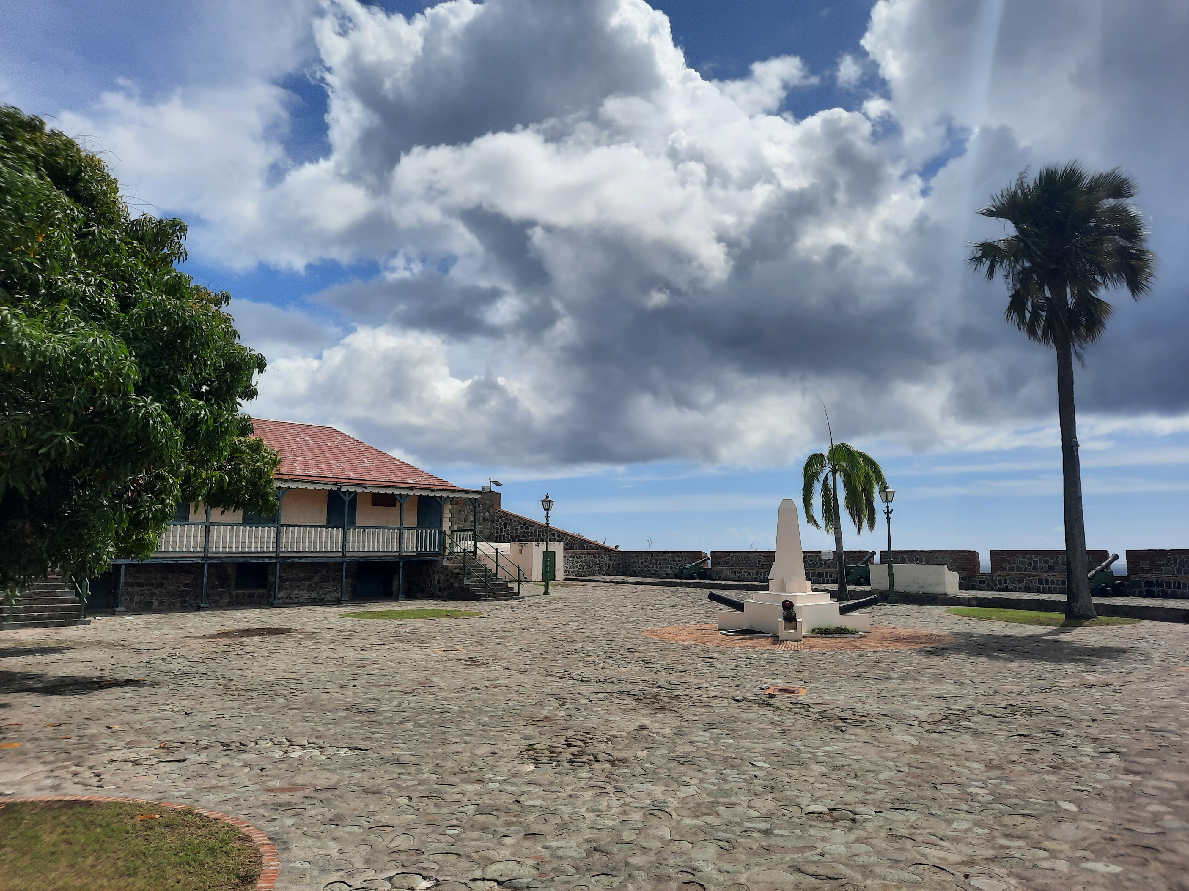
Where should you visit on Sint Eustatius? Start with Fort Oranje, the historic streets of Oranjestad and the Lower Town waterfront, then choose among the Quill volcanic park, a gentler botanical garden visit, Boven’s northern hills or a supervised marine adventure. The island is small, but the best ten places do not fit one effortless day because they require different amounts of walking, guiding and care.
Statia, as residents often call the island, is part of the Caribbean Netherlands. Its history includes a busy eighteenth-century trading port connected with Atlantic colonialism, enslavement and a diverse merchant community. Today the island also protects endangered turtles, reef ecosystems and distinctive volcanic habitats. The most rewarding tour places human stories and natural science beside the island’s impressive views.
October is hurricane season, so always check local weather and live access. STENAPA manages the natural parks and sets fee and conservation requirements, while heritage landmarks have their own hours and fragile structures. The 250th anniversary of the celebrated First Salute in 1776 makes 2026 especially interesting for historic exploration; it does not remove the need to distinguish accurate history from simplified tourism slogans.
eduKate · Caribbean history, nature and learning
Choose your Statia reading route
Ten places compared · Oranjestad history · The Quill · Northern hills and coast · Marine heritage · Plan safely
Before travelling: confirm STENAPA hiking fees, any closures and marine-park supervision rules. Zeelandia is for responsible observation, not a recommended swimming beach.


The top ten at a glance
The places below represent different kinds of visits rather than a sequence to race through. Select by your interests and the actual weather, opening and conservation arrangements.
| Place | Why visit? | Before going |
|---|---|---|
| 1. Fort Oranje and the Oranjestad harbour view | Understand the trading port and the First Salute | Heritage events, historical parapets and a working capital |
| 2. Oranjestad Lower Town and the merchant warehouses | Discover ruins, revived businesses and maritime history | Sea erosion and active harbour operations |
| 3. Honen Dalim Synagogue ruins and Jewish cemetery | Understand worship, migration and complicated religious history | Fragile masonry and burial-site respect |
| 4. Sint Eustatius Historical Foundation Museum | Make the island’s history understandable through objects and archives | Museum hours and available tours |
| 5. The Quill crater rim and rainforest | Study volcanic relief and contrasting ecological zones | STENAPA nature fee and steep trails |
| 6. Miriam C. Schmidt Botanical Garden | Learn conservation at a gentler pace | Restoration work, close the animal-control gate |
| 7. Boven National Park and the Venus Bay outlook | Meet the dry, rugged side of Statia | Ridge exposure and a nature-fee tag |
| 8. Zeelandia Beach and protected turtle habitat | Observe Atlantic waves and nesting-beach conservation | Do not swim; avoid nesting areas |
| 9. Fort de Windt and the southern sea passage | Read the geography of coastal defence | Historic masonry and track condition |
| 10. St Eustatius National Marine Park and underwater heritage | Explore reefs and wrecks through guided marine science | Authorised dive centre and reserve rules |
1. Fort Oranje and the Oranjestad harbour view
Why this place matters: Fort Oranje is the best introduction to Sint Eustatius because its commanding position above Oranje Bay immediately explains the connection between government, shipping and the town. From the fortified courtyard, visitors can see a working waterfront where a bustling eighteenth-century merchant port once operated. The landmark is not important only for attractive old cannons. It provides a starting point for discussing trade, colonial power and the way an island community has reused its historical buildings.
Look beyond the photograph: On 16 November 1776 the island returned a salute to a vessel flying the emerging United States flag, an event commemorated as the First Salute. The 250th anniversary is particularly prominent in 2026. Popular accounts sometimes treat the cannon response as a simple moment of diplomatic recognition; a historically careful visit should recognise the event while distinguishing ceremonies, interpretations and political law. Trading prosperity also depended on an Atlantic economy of plantation commodities and slavery. The fort’s visible walls, later restorations and modern memorial features need to be understood as different historical layers.
How to visit responsibly: Check public access and event arrangements through the island’s tourism office, which is associated with Fort Oranje. Historic paving and open parapets need sensible footwear and adult supervision of children. Do not climb guns, touch fragile masonry or intrude on civic functions. If a specific display is closed, a permitted public view over the bay and a well-labelled history map remain worthwhile.
Learning question: On a harbour map mark what a defensive lookout can see and what lies behind the cliff. Which claims can the map prove and which require historical records?
Back to ten-place index · Next place
2. Oranjestad Lower Town and the merchant warehouses
Why this place matters: Lower Town, beside Oranje Bay, reveals why Statia came to be nicknamed the Golden Rock. Historic warehouses and traces of former quays show the scale of commercial infrastructure that once served Atlantic merchants. Today restaurants, marine businesses and public waterfront areas occupy parts of the same shore. That mix is important: Lower Town is neither an untouched archaeological zone nor a single resort complex. Visitors can learn how an island economy changes without assuming the community stopped evolving after its trading peak.
Look beyond the photograph: Archaeological surveys have found warehouse floors, pottery, materials used in the sugar economy and evidence of repeated adaptation to storm damage. A restored eighteenth-century warehouse converted to a restaurant demonstrates a modern form of heritage reuse, but it does not show how every historical merchant worked or lived. Much of this port’s trade was linked with enslaved labour and exploitative plantation systems across the Caribbean. A thoughtful tour acknowledges those people alongside the merchants whose names appear in documents.
How to visit responsibly: Stay on lawful waterfront paths and keep clear of working quays. Walls exposed to rain, waves and cliff erosion can be unstable, so never enter an unmarked ruin merely because it looks accessible. Current restaurant or diving-centre hours differ from heritage-site access. A harbour view from Fort Oranje is a useful fallback if storm conditions make the lower shore inappropriate.
Learning question: Choose one original-looking wall, one reused historic building and one contemporary business. What can you establish about each without inventing its age or former owners?
Back to ten-place index · Next place
3. Honen Dalim Synagogue ruins and Jewish cemetery
Why this place matters: The ruins of Honen Dalim in Upper Town are a powerful reminder that eighteenth-century Statia’s trading culture was religiously diverse. The roofless synagogue, its characteristic arches and the historic Jewish cemetery connect commerce with families, religious practice and the consequences of empire. This is a meaningful heritage place rather than a backdrop for novelty photographs. The sense of history comes from both what survives and what visitors must seek in documentary sources.
Look beyond the photograph: The Dutch Cultural Heritage Agency describes the synagogue as completed in 1739, and its study records surviving yellow-brick walls, later structural stabilisation and evidence of a ritual bath. Jewish merchants contributed to the island’s commercial life yet also experienced discrimination, dispossession and forced movement during periods of conflict. Cemetery inscriptions can establish names, languages and dates, but the surviving stones cannot tell every story or reveal the lives of people who left no monument. A sensitive visit should resist oversimplifying this history into an account of wealth alone.
How to visit responsibly: Ask about access to the ruins and keep to signed visitor sections. Never climb walls, rub inscriptions, shift loose stones or disturb graves. Quiet behaviour and respectful clothing are appropriate in a historically sacred setting. If conservation work restricts entry, learn from government heritage publications rather than seeking a hidden route behind a barrier.
Learning question: Record one architectural observation and one inscription. Separate what is directly visible from what a historian must infer about worship and the wider community.
Back to ten-place index · Next place
4. Sint Eustatius Historical Foundation Museum
Why this place matters: An island famous for one historical cannon salute deserves more than a single heroic story. The Historical Foundation Museum helps visitors investigate family life, trade, archaeology and the changing identities of people who lived on Statia. It is a good companion to Fort Oranje, the synagogue and the former warehouse quarter, especially for readers who want original evidence rather than only scenery and dated descriptions.
Look beyond the photograph: Statia Tourism identifies the Historical Foundation as an organisation established in 1974 to collect and preserve the island’s documentary and material heritage. It also supports education and projects involving younger residents. A historic household object can reveal a technology or routine; a letter can show one person’s viewpoint; a later interpretive panel brings several sources together. The strongest visitor learns to tell original objects and copies apart and does not assume a particular exhibition represents all the island’s peoples.
How to visit responsibly: Confirm the museum’s opening and any historical walking-tour schedule before travelling. Smaller local institutions may not follow the timetable of large metropolitan museums, and community events can affect staff availability. Leave time to read the labels and ask respectful questions. If indoor entry is unavailable, a walk around accessible heritage streets using an official map can still provide meaningful learning.
Learning question: Choose two artefacts of different dates and write down the material, documented use and the uncertainty still remaining. What evidence would answer your next question?
Back to ten-place index · Next place
5. The Quill crater rim and rainforest
Why this place matters: The Quill’s profile rises above southern Sint Eustatius and is the island’s most recognisable natural landmark. Its dormant volcanic crater offers a different experience from historical Oranjestad. A hike toward the rim changes the visitor’s relationship with the landscape: drier lower vegetation gradually gives way to different plant forms, while the sheltered crater interior supports its own microclimate. The view is memorable, but the ecological contrast makes the site worth studying even when clouds hide the horizon.
Look beyond the photograph: The island’s official tourism site places the Quill at about 601 metres high. STENAPA manages the protected slopes and a trail network leading toward the rim and crater. Some species and habitats have faced the pressures of storms, introduced animals and changing human activity; a landscape labelled protected does not mean it has never been altered. Volcano science also distinguishes a dormant landform from current monitoring elsewhere in the Caribbean. The age or future behaviour of a volcano cannot be determined from the colour of its forest.
How to visit responsibly: Obtain a nature-fee tag and ask STENAPA about the current condition of the specific route. A rim walk and descent into the crater are not identical commitments. Rain makes steep steps slippery; start early, carry drinking water and wear suitable footwear. People with limited mobility may prefer a legitimate lower public viewpoint. Never improvise a shortcut through protected vegetation.
Learning question: Compare the outer slope, sheltered forest and crater rim. What explains their ecological differences, and what measurements would be needed to confirm your ideas?
Back to ten-place index · Next place
6. Miriam C. Schmidt Botanical Garden
Why this place matters: On the lower southern slope of the Quill, the Miriam C. Schmidt Botanical Garden provides a quieter alternative to an extended crater hike. Visitors can observe plants, insects, lizards and birds in a setting designed for protection and education. The garden is especially rewarding for families willing to read signs and watch rather than expecting dramatic wildlife encounters. It also gives visitors a place to appreciate the ongoing labour behind conservation.
Look beyond the photograph: STENAPA explains that the garden was founded in 1999 and remains a work in progress because of hurricane damage, drought and roaming animals. That is a useful lesson: a conservation area is never finished simply because it has a name or a fence. Different plants may be native, endemic or cultivated for display; they cannot all be classified by appearance. The garden can also offer views toward St Kitts, and seasonal whale migration may be visible at appropriate times, though no animal sighting can be promised.
How to visit responsibly: STENAPA normally describes free entry from sunrise to sunset and asks visitors to close the gate behind them to keep animals out. Verify which paths are currently suitable, especially during restoration. Do not pick leaves or flowers or approach wildlife closely. Bring water and respect any instructions about picnic or special-event areas. The garden need not be physically strenuous to provide a meaningful afternoon.
Learning question: Choose two different leaves and note their shapes and growing conditions. What makes a botanical label stronger evidence than a guess based on colour?
Back to ten-place index · Next place
7. Boven National Park and the Venus Bay outlook
Why this place matters: Boven National Park is a striking contrast with the Quill. On the northern hills, cacti, acacia, grassland and rocky slopes replace the sheltered rainforest environment of the southern volcano. Walking a permitted route can reveal views of windswept Atlantic coves, including Venus Bay. It is worthwhile even for someone who visited another part of the island’s natural landscape, because each park illustrates how exposure, relief and history shape habitats.
Look beyond the photograph: STENAPA manages Boven alongside the Quill, with protected status dating from 1997. The park has walking trails through ridges and valleys, with some old walls and remains of past land uses. An open dry hillside does not mean nature is absent: seabirds, native plants and insects may depend on habitats less visually lush than forest. Old vegetation patterns can also reflect grazing and human changes, so the word natural should not be mistaken for a claim of no historical disturbance.
How to visit responsibly: Check the individual trail status and obtain the required nature-fee tag. Exposed ridges, loose rock, heat and strong wind can make a short-looking walk demanding. Do not descend toward Venus Bay unless STENAPA confirms a permitted route suitable for your group. An Atlantic-facing inlet may be beautiful but unsafe to swim. A dry-land viewpoint or shorter marked walk is a reasonable alternative.
Learning question: Compare an open northern slope with a photograph of the Quill. What role might rainfall, wind and elevation play, and where would you need more evidence?
Back to ten-place index · Next place
8. Zeelandia Beach and protected turtle habitat
Why this place matters: Zeelandia Beach shows why a beautiful coastline is not always a recreational swimming site. The beach faces the Atlantic and is known for dark volcanic sand, rough water and sea-turtle nesting. Visitors can learn about marine conservation through a permitted observation walk rather than entering the water. The exposed landscape also differs from the calmer leeward side of Statia, offering a practical geography lesson about wave energy.
Look beyond the photograph: Conservation information identifies this shore as important for leatherback, hawksbill and green turtles during their nesting periods. Hatchlings can be disoriented by bright lights, while vehicles and litter can damage nests or block routes to the sea. WWF Dutch Caribbean reported a 2026 project introducing turtle-friendlier lighting along Statia’s waterfront, a reminder that conservation often involves ordinary roads and public infrastructure rather than dramatic marine encounters alone. Visitors should never expect or demand the sight of a nesting turtle.
How to visit responsibly: Swimming at Zeelandia is strongly discouraged because of currents and undertow. Inspect current access and any turtle signs, stay away from cliff edges and avoid walking through sensitive nesting zones. Do not drive on the beach, use a bright flashlight near turtles or organise an unauthorised night encounter. Weather and erosion can change even a modest walking route. A safe viewing spot is enough.
Learning question: Draw the route between a turtle’s nest and the ocean. How could lighting, rubbish or vehicle tracks obstruct the animal without a visitor ever touching it?
Back to ten-place index · Next place
9. Fort de Windt and the southern sea passage
Why this place matters: Fort de Windt offers a second perspective on Statia’s historic defences, looking toward the sea passage associated with neighbouring St Kitts and Nevis. It is not simply another version of Fort Oranje. A fort’s position reveals the particular coastline or approach its designers considered important, which can be connected with the movement of sailing vessels and the island’s many changes of administration. The site is valuable for visitors who enjoy understanding military and maritime geography without requiring a full museum display.
Look beyond the photograph: The surviving defensive landscape belongs to a wider history of colonial rivalry and international trade. Older forts and batteries often underwent changes as technology and political control shifted, so a wall seen today cannot automatically be assigned to a single year. The commercial economy watched by these defences involved unequal labour and slavery as well as international merchants. A responsible historical interpretation connects geography with those human circumstances rather than merely counting guns or naming commanders.
How to visit responsibly: Confirm with the tourism office or a local guide that the road or path is open and appropriate. Historic fort sites may have uneven surfaces and unprotected coastal edges, with no staffed entrance or accessible facilities. Do not climb fragile masonry or enter private land to reach a supposedly superior viewpoint. In poor weather an authorised lookout or a map-based comparison of the southern and western coasts is preferable.
Learning question: Mark Fort Oranje and Fort de Windt on an island map. How might a defender use the two sites differently, and what evidence would test your interpretation?
Back to ten-place index · Next place
10. St Eustatius National Marine Park and underwater heritage
Why this place matters: Statia’s underwater landscape connects its famous trading past with a functioning coral-reef ecosystem. The St Eustatius National Marine Park protects waters around the island, including areas with eighteenth-century wreck-related material and sites used by sharks, rays and sea turtles. For qualified divers, an authorised underwater visit can make that connection vivid. For non-divers, official information and the view from Lower Town can provide a meaningful interpretation without entering a hazardous marine environment.
Look beyond the photograph: STENAPA reports that the park was established in 1996, with two marine reserve zones where fishing and anchoring are prohibited. Historic wreck sites and submerged urban remains are archaeological resources, not objects to collect as souvenirs. Coral reefs are living ecosystems that require protection from anchoring, touching, feeding and careless swimming. The presence of a large fish on a dive is an observation from one moment, not a complete measure of an ecosystem’s health. Scientists use longer-term monitoring to understand changes.
How to visit responsibly: Dives must be supervised by a recognised local dive centre; snorkelling within marine reserve areas also requires approved supervision. Confirm operator licensing, weather, the diver’s qualifications and the current nature or dive fee before booking. Never touch coral or wrecks, feed fish, disturb rays or take artefacts. Some shore areas may be more appropriate for inexperienced visitors but still require local condition checks. Safety must override a promotional underwater photograph.
Learning question: Compare an old shipwreck fragment with a coral colony. How do scientists gather evidence from each while avoiding physical damage?
Back to ten-place index · Build a route
Build a Statia visit by theme, not by speed
An introductory history day might pair Fort Oranje with a short walk through Upper Town, the historical museum, and the Lower Town waterfront where access is safe. That supplies connections between buildings, artefacts and the harbour without exhausting the group. A second day could focus on the garden and a suitable Quill trail, leaving Boven’s dry ridges for another outing. Zeelandia is best understood as a conservation site rather than a swimming destination.
If marine life is your primary interest, choose a registered dive centre and let its guides explain the reef and underwater archaeological features. Do not simply hire equipment and dive into a protected reserve. Travelers with young children, limited mobility or little hiking experience can learn plenty through public viewpoints, museums, the garden and interpreted materials. A visit that omits the most difficult trail can still be more rewarding than a risky attempt to include all ten places.
Important access and conservation decisions
- Pay the required STENAPA nature contribution before visiting the protected hiking parks and follow current trail-condition notices.
- Treat the Quill rim and the descent into its crater as different levels of physical commitment; choose appropriate routes and avoid heavy rain.
- The Botanical Garden is an active restoration area. Respect the gate and leave the plants and wildlife undisturbed.
- Do not swim at exposed Zeelandia Beach. Give nesting turtles and shorebirds space, and keep artificial lighting away from nests.
- Do not disturb Honen Dalim or cemetery remains. Fragile historic masonry and graves deserve careful, quiet treatment.
- Lower Town combines heritage with a working waterfront. Sea erosion, storms and private operations can restrict access.
- All national marine-park dives require authorised dive-centre supervision, with extra rules for snorkelling within reserve zones.
- Atlantic hurricane-season weather can make a road, rocky lookout or marine excursion unsuitable even when it looks open on a map.
- Support local museums and tour operators without treating residents as photographic scenery.
Three routes for different types of traveller
For heritage enthusiasts, start at the museum and follow the story from Fort Oranje to the port and the Jewish community’s ruins. For ecology-minded families, choose the botanical garden and an appropriately gentle public viewpoint and learn how the habitats differ. For active walkers, obtain a proper Quill or Boven route from STENAPA and leave enough time for weather and a safe return. These are alternatives and need not be combined in a single day.
Frequently asked questions
Is Statia the same island as Sint Eustatius?
Yes. Statia is the common shortened name of Sint Eustatius, a special municipality of the Netherlands in the Caribbean.
Why is Fort Oranje important?
It was central to the island’s defence and port history and is linked with the celebrated First Salute of November 1776, whose 250th anniversary falls in 2026.
Do hikers need a fee or permission in the national parks?
STENAPA and Statia Tourism explain the nature-fee system for the Quill and Boven parks. Obtain the current tag and verify the particular route before starting.
Is the Quill crater hike suitable for young children?
Not every route. Reaching the rim and descending into the crater can involve steep, muddy paths and heat. Choose the least demanding option appropriate for the group.
Can people swim at Zeelandia Beach?
The exposed Atlantic coast has dangerous currents and rough surf; Zeelandia is best treated as a conservation and observation location, not a recommended swimming beach.
What can families learn at the Botanical Garden?
They can compare native and cultivated plants and study how restoration is ongoing following hurricane damage, drought and pressures from roaming animals.
Can divers collect artefacts from a shipwreck?
No. Archaeological objects and marine life are protected, and local marine-park dives require supervision from an authorised dive centre.
What is the significance of Honen Dalim?
The synagogue and cemetery document eighteenth-century Jewish life and religious diversity in Oranjestad alongside the island’s complex trade and colonial history.
Should visitors attempt ten sites in one day?
No. A better trip chooses one or two geographic areas, allows time for interpretation and respects weather, mobility, opening and conservation restrictions.
Create an evidence-based island field notebook
For each place, write what you directly observed, what the official interpretation explains and a question still open. A cannon at Fort Oranje says something about defence but cannot establish every diplomatic detail. A cemetery inscription provides names and dates but not the complete lives of those buried. A Quill trail reveals vegetation differences without proving their long-term causes. Zeelandia Beach can be studied without approaching a turtle or entering dangerous water. These distinctions make observation more accurate and respectful.
Try one map problem as a family: compare the direct distances among the Quill, Boven and Oranjestad with the travel time and difficulty of available roads or protected trails. Ask what data would be needed to choose a safe route, rather than guessing from a straight line. The value of making working and assumptions explicit is also illustrated by eduKate’s Secondary 1 Mathematics Tutor Clementi | Small Groups Tutorials.
Continue reading about Statia
Top 10 Things to Do When Visiting and Touring Sint Eustatius · Top 10 Things to Learn When Visiting and Touring Sint Eustatius · Explore nearby Saba · World Travel Hub
Official references and media credit
Sources reviewed 20 October 2026, Singapore time. The tourism and conservation materials describe the island and visitor responsibilities, not guaranteed real-time access or safe sea conditions. Follow current STENAPA notices, heritage operators and weather advisories for your actual travel date.
- Statia Tourism — official destination information
- Statia Tourism — historic Oranjestad and the waterfront
- Statia Tourism — The Quill
- Statia Tourism — hiking, Boven and nature-fee advice
- Statia Tourism — 2026 anniversary and travel questions
- STENAPA — Quill, Boven, garden and marine park
- STENAPA — garden opening and restoration
- STENAPA — hiking and marine park FAQs
- STENAPA — dive centre supervision
- Sint Eustatius Government — heritage sites including Honen Dalim
- Netherlands Cultural Heritage Agency — Landscape Biography of Sint Eustatius, 2026
- Caribbean Birding Trail — Zeelandia Beach turtle habitat
- WWF Dutch Caribbean — turtle-friendly streetlights, August 2026
- Photo by Ymnes — Fort Oranje, 2025, CC BY-SA 4.0
- Creative Commons Attribution-ShareAlike 4.0
A carefully paced history-and-nature day
Suppose a family has one full day and is most curious about how people and landscapes interact. Begin at the public historic core around Fort Oranje. Look at the height of the cliff and the position of Lower Town, then ask why trading warehouses stood near the water while military and civic functions occupied higher ground. The answer cannot be reduced to one factor: ship access, defensive visibility, road gradients and the risk of coastal flooding all matter. Check museum hours before building the rest of the day around an indoor visit.
For the afternoon, choose one manageable protected-nature experience rather than a rushed pair of hikes. The botanical garden can be suited to visitors who want to compare plants, native habitat and conservation restoration without attempting the Quill crater descent. A more experienced hiking party might choose a properly open Quill trail instead. Before either choice, confirm STENAPA advice, carry suitable water and understand that shaded tropical forest can still be hot, slippery and tiring. This decision is more important than the number of places photographed.
Three common planning errors and how to repair them
Error one: treating Zeelandia Beach like a calm swimming bay. Its Atlantic exposure and dangerous currents make that a poor assumption. The repair is to use it, when allowed, as a shorebird and turtle-conservation learning site from a safe distance. Do not approach a nest or follow a turtle with lights. If a beach-swimming experience is important to the group, ask local specialists for appropriate current conditions at a different location rather than inventing one from a photograph.
Error two: assuming that a dive certificate permits unrestricted access to archaeological wrecks. The marine park has local supervision and reserve regulations. The repair is to contact an authorised dive operator, describe your experience accurately, pay the appropriate fee, and follow the route and conservation briefing. A fragile underwater artefact is evidence for everyone, not a souvenir. The same principle applies above water at synagogue walls, burial markers and waterfront ruins.
Error three: interpreting the First Salute without its wider Atlantic context. The event of 1776 is historically important, and its 250th anniversary in November 2026 is an opportunity to learn. But merchant prosperity was bound up with colonial rule and enslaved labour. A better reading combines the commemoration at Fort Oranje with a museum account, the Lower Town trading landscape and individual histories where available. A place can hold pride, pain and important international connections at the same time.
One final habit improves every itinerary: state clearly what is observed now, what happened in the documented past and what is still uncertain. A historic photograph establishes one view at one date; it does not certify current access. A national-park map establishes a route; it does not replace live trail closures. A bird sighting establishes presence at one moment; it does not reveal an entire breeding population. Bringing those distinctions into travel writing makes even a short visit more valuable.