
Where can visitors go in Tokelau? The most meaningful places are its three inhabited atolls—Atafu, Nukunonu and Fakaofo—and their distinct villages, lagoon shores, reef environments and public-service landscapes. Tokelau has no conventional tourist attractions or established resort industry. This guide therefore identifies ten real places or settings worth understanding, not ten ticketed experiences available on demand.
Tokelau is a New Zealand-administered Pacific territory roughly 500 kilometres north of Samoa, made up of low coral islets enclosing lagoons. There is no airport. The government directs intending visitors to the small-vessel services from Apia, with schedules and accommodation arranged through official transport personnel and the village Taupulega offices. A visitor must not interpret a scheduled ship stop as permission to land, wander through homes or join community activities uninvited.
The islands are valued most when approached as lived communities with their own authority, language and customary land arrangements. A lagoon shore may be a working boat area, and a school or hospital is a vital public service rather than a tourist display. The list below is designed to make geography, culture, engineering and history understandable while keeping the needs of residents ahead of sightseeing ambitions.
eduKate · Pacific atolls, community and environmental learning
Choose a responsible Tokelau reading route
All ten place-based topics · Atafu · Nukunonu · Fakaofo · Travel and permission
Critical: Tokelau has no airport and no established tourism industry. Confirm vessel arrangements, guest accommodation and village approval before making travel plans. School, clinic and power infrastructure are not public attractions.


Ten Tokelau places and settings at a glance
These are not commercial sightseeing stops. Some are inhabited settlements, others are marine environments or infrastructure that should be viewed only with community permission. The categories help readers choose whether the aim is learning, a family visit or an explicitly arranged research journey.
| Place | Reason to understand it | Access requirement |
|---|---|---|
| 1. Atafu's inhabited village and communal walking lanes | Northern atoll settlement, family land and daily services | Visit by prior community arrangement; not a public heritage park |
| 2. Atafu's lagoon-side vaka and small-boat landing | Traditional canoe knowledge and practical maritime transport | Working landing, permission and safe weather |
| 3. Atafu's outer reef margin and ocean-side coastal defences | The difference between lagoon shelter and open-Pacific risk | No independent reef crossing or storm-edge exploration |
| 4. Nukunonu Fale village and its lagoon-facing street network | A southern lagoon-side community with distinctive lanes | Homes and council areas need host permission |
| 5. The Nukunonu–Motuhaga bridge and connected settlement | A lifeline linking homes with hospital and services | Working public infrastructure, not a tourist bridge stunt |
| 6. Nukunonu lagoon and customary reef-motu areas | The largest Tokelau lagoon viewed as a working ecosystem | Community boat consent and lagoon ecology |
| 7. Fakaofo Fale main village and meeting-house landscape | Traditional village heart and the role of the Taupulega | Village gathering areas and homes are not public museums |
| 8. Fenuafala village and public-service surroundings, Fakaofo | A second settlement developed to relieve crowding | School and hospital never open to casual tourists |
| 9. Fakaofo's Fale–Fenuafala lagoon crossing and landings | Everyday inter-islet movement rather than a tourist ferry | Boat owner permission, currents and loading safety |
| 10. Fakaofo's seawall and solar-infrastructure viewing corridor | Climate adaptation and locally managed renewable electricity | No entry to work sites or sensitive infrastructure |
1. Atafu's inhabited village and communal walking lanes
Why it matters: Atafu is Tokelau's northernmost inhabited atoll, and its main village occupies part of a low coral islet beside the lagoon. A walk through the settlement with an invited local host can show how everyday activities fit into a very narrow strip of land surrounded by water. There is no grand tourist boulevard here; the significance lies in how homes, working paths, churches, meeting places and community facilities support a small society. Atafu is an appropriate first place to learn about faka-Tokelau, the Tokelauan way of life, but that does not mean its residents have arranged their homes as a visitor attraction.
Geography, history or community context: The Government of Tokelau describes Tokelau's three atolls and explains that Atafu has one principal inhabited village. Its affairs are shaped by the Taupulega, or council of elders, within a structure that places family and community relationships at the centre of decision-making. The layout of the settlement is partly a response to limited land and customary ownership. Coconut trees and coral paths may be visible, yet a traveller should avoid claiming that every family uses the same routines or that houses are open for inspection. Community life has changed through education, migration, telecommunications and renewable-energy projects, as well as through enduring customs.
Visiting responsibly: Ask the relevant Taupulega office to help arrange an invitation or an appropriate host before travelling. A passenger ticket to Tokelau is not automatic permission to photograph private homes or enter a council meeting, church service or school. Respect quiet hours and local protocols, including the language and customs your host explains. Walk only on permitted lanes; narrow settlement paths need to remain available for residents, children and essential services. Tokelau has no ordinary public transport system, so an invitation and a local plan matter more than a preloaded mapping app.
Field-learning prompt: Sketch a generic narrow coral motu with one village path, houses and lagoon shore. Explain how land scarcity can influence settlement form while noting why an individual family's choices cannot be inferred from a map alone.
Return to the ten-place index · Next place
2. Atafu's lagoon-side vaka and small-boat landing
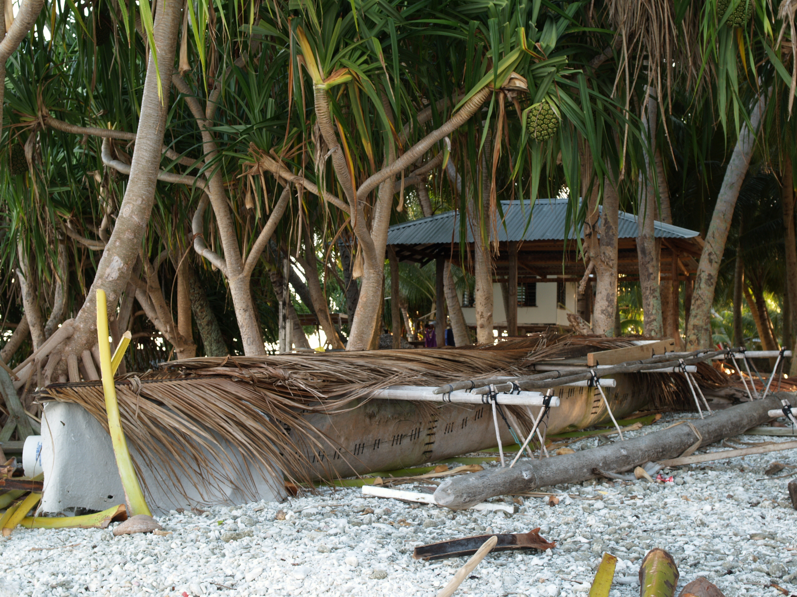
Why it matters: The lagoon-side canoe and small-boat working areas of Atafu reveal a form of infrastructure more important to the community than any visitor marina. Traditional vaka and modern boats illustrate how residents fish, move supplies and travel around reef-bound islets. Looking at the design of a canoe can prompt questions about local materials, stability, balance and the knowledge needed to use a vessel in a shallow lagoon. A historic photograph of a vaka resting on the shore is a valuable cultural reference, but it is not evidence that visitors can hire that exact craft today.
Geography, history or community context: The Tokelau Government describes small boats as essential local transport. The relation between village and lagoon is geographical: sheltered water offers certain working advantages, while the reef edge and ocean passage carry different hazards. Boatbuilding and navigation are living practices, not staged 'ancient traditions' frozen at one historical date. Modern engines, imported materials and careful maintenance all coexist with knowledge passed within families. A visitor who sees a canoe onshore should ask what its owner wants to share rather than assume a particular boat belongs to an interpretive museum.
Visiting responsibly: Approach the working shore with a host and avoid boat loading, hauling, repairs or a tide-dependent passage. Never touch equipment, climb into a canoe or offer children an unarranged ride. For any trip on the lagoon, insist on a responsible local operator or authorised community contact who assesses boat capacity, weather, life jackets and safe return. Reef water can look calm from a village path while the ocean-side passage is dangerous. If an outing is cancelled, a lawful shore observation remains a meaningful choice.
Field-learning prompt: Compare an outrigger canoe with a modern powered boat on a labelled drawing. What makes each stable, what energy source moves it, and what would a visitor need to verify before inferring its purpose?
Return to the ten-place index · Next place
3. Atafu's outer reef margin and ocean-side coastal defences
Why it matters: Atafu's outer shoreline is a place to study exposure rather than seek a hidden beach. On one side of a motu lies the lagoon; on the other, waves break against reef and shore facing the open Pacific. The physical difference may be apparent within a short walk, yet the risks change sharply. This is an excellent setting for explaining why the same atoll needs safe boat passage, seawall maintenance, storm preparation and community-wide decisions about coastal space. Not every part of the coast has a visitor path.
Geography, history or community context: Tokelau Government disaster-risk documents describe reef-bound islets only a few metres above sea level, with steep drop-offs beyond the outer reef. Wave overwash and cyclones are longstanding concerns, and climate change adds pressure through rising sea levels and changing coastal conditions. A line of stones or a seawall is a piece of community protection infrastructure, not a tourist observation deck. Sea-level change should not be 'proved' from one photograph of a tide mark; long-term measurements, storm records and engineering surveys are needed. The reef also supports living marine habitats that can be damaged by careless walking.
Visiting responsibly: Only go where a local host or responsible authority confirms that shoreline access is appropriate. Do not walk on damaged seawalls, approach breaking surf or attempt to cross a reef flat at low tide without specialist local permission and guidance. Flooding hazards can persist after storms. Children should remain well away from ocean-side edges; even an apparent calm period can be followed by a dangerous wave. If access is unsuitable, use the official government risk-reduction maps to study how protective measures relate to the settlement.
Field-learning prompt: Draw a cross-section from lagoon to motu to outer reef and deep ocean. Mark where a wave could overwash the shore and explain what additional measurements an engineer would need before designing protection.
Return to the ten-place index · Next place
4. Nukunonu Fale village and its lagoon-facing street network
Why it matters: Nukunonu's principal village is situated along the south-western edge of its large lagoon. Community descriptions identify a network of lanes including Ala Gatai, the Lagoon Road, Ala Loto, the Middle Road, and Ala Tua, the Ocean Road. These names make geography immediate: people organise movement according to the two very different edges of the atoll and the limited land between. A hosted walk can reveal why roads, gardens and buildings occupy their particular positions, but the streets are not a model village built for paying visitors.
Geography, history or community context: Nukunonu is the largest of Tokelau's three atolls by land area, although even that area is small. The principal village has strong Catholic traditions alongside Tokelau's wider connections with Samoa, Tuvalu and New Zealand. Religious, educational and community activities remain part of real residents' lives, not an entertainment timetable. The Tokelauan language is used in the community and schools. A visitor might hear speech, music or a gathering but cannot assume the right to record, interpret or enter it. A local guide's explanation helps avoid presenting every difference in houses or street use as timeless custom.
Visiting responsibly: Arrange accommodation and a host before arrival. The government's older FAQ identifies a small guesthouse on Nukunonu, but room availability and prices must be confirmed rather than copied from an old page. During any walking visit, do not photograph people at close range without consent or enter family yards. Respect church services and the Taupulega's instructions. Some coral paths may be uneven, and sun exposure can be strong; choose sensible walking hours and keep village traffic clear.
Field-learning prompt: Use the three lane names to create a map key. Why do they reflect geography, and what can they tell you about orientation without revealing private details about households?
Return to the ten-place index · Next place
5. The Nukunonu–Motuhaga bridge and connected settlement
Why it matters: The concrete bridge connecting Nukunonu's principal settlement to Motuhaga is a meaningful place because it makes the geography of essential services visible. What may look like a short crossing on a visitor photograph is a connection between homes, transport and health care. The government village description identifies Motuhaga as a newer settlement, with the hospital located there. A bridge in such a setting is not merely a convenience; it helps the community function when people need medical attention, supplies or access across the channel.
Geography, history or community context: A historical government asset-management study describes the bridge as a reinforced-concrete lifeline and documents past wear and corrosion. That older report is not a reliable statement of its present structural condition: repair, replacement and maintenance can change an asset after a survey. The importance is the wider planning question. A small island community must coordinate roads and structures across salt water with limited materials and costly imports. Even routine maintenance has consequences for budgets, transport and local labour. Visitors should appreciate the scale of that task without treating a working health facility as an architectural attraction.
Visiting responsibly: Ask your host which approach and crossing remain publicly permitted and whether any maintenance restricts use. Do not block the bridge to take photographs, climb its guardrails or enter the hospital for sightseeing. Health buildings are private and sensitive workplaces, and taking images of patients or staff is inappropriate without authorisation. A clear view of the bridge from an agreed public position is enough for geography learning. Heavy rain, unusually high water or structural notices should lead to postponement, not a closer inspection by untrained visitors.
Field-learning prompt: Draw a two-islet diagram showing where a road, bridge and hospital connect. What would happen if the bridge became unavailable, and which services would need alternative transport?
Return to the ten-place index · Next place
6. Nukunonu lagoon and customary reef-motu areas
Why it matters: Nukunonu's lagoon is an exceptional physical landscape, encircled by reef islets whose combined land area is tiny compared with the water enclosed. Its broad lagoon gives visitors a clear way to understand coral-atoll geography, but it is also part of the community's livelihood system. Fishing, small-boat transport and marine stewardship are not activities arranged primarily for tourists. An authorised lagoon view or supported boat outing can illustrate reef structure, deep-water connections and the practical importance of calm-water passages.
Geography, history or community context: Tokelau's environment includes lagoons, reef flats and deep ocean waters whose species and ecological functions differ. Fish, invertebrates and other marine organisms are part of food and cultural systems as well as natural habitats. The government notes concerns about overharvesting, pollution and pressure on limited island resources, showing why an attractive marine environment can be vulnerable. Coral reefs also affect wave energy and shoreline protection, but a lagoon is not a guarantee of safe swimming or snorkelling. The water can have currents, reef hazards and areas used for work or culturally restricted activities.
Visiting responsibly: Discuss any boat movement, fishing or snorkelling with the host and village authority. Do not take fish, shells, coral or other marine organisms as souvenirs, and never enter a private motu simply because it appears empty. Local rules may vary with custom and resource management. If a guide authorises a trip, check vessel safety, weather, capacity and return. A lagoon panorama from the village can be educational without committing to a water excursion. The aim is to observe a working ecosystem without changing it.
Field-learning prompt: On a map shade the lagoon, the surrounding reef islets and the outer ocean. Explain why the water area may exceed the land area so dramatically and how that affects settlement and transport.
Return to the ten-place index · Next place
7. Fakaofo Fale main village and meeting-house landscape
Why it matters: Fakaofo is Tokelau's southernmost atoll, and Fale is its historic main settlement on a compact motu. The village is densely built, with communal spaces, paths, houses and areas related to governance and faith. For a genuinely invited visitor, the most valuable experience may be listening to a local explanation of how people make collective decisions and care for one another. The physical smallness of the island creates an immediate lesson in the limits of space, but it is inappropriate to treat residents' kitchens, houses or council spaces as a tourism exhibit.
Geography, history or community context: The Tokelau Government explains that the Fale settlement became crowded, contributing to the later development of a second settled motu, Fenuafala. The Taupulega, or village council of elders, has an important role in local matters, and the wider General Fono connects the three atolls' governance. Faka-Tokelau values include community cooperation and shared responsibilities. Outsiders must be especially careful not to describe these values as if every person holds an identical view or as if culture has not changed. Migration and new infrastructure have affected village life while families retain meaningful links with the land and lagoon.
Visiting responsibly: Visit only through arrangements made with the appropriate community office and host. Religious buildings, council meetings and celebrations have their own protocols. Do not record ceremonies, political discussions or children without explicit consent. The compact village paths are essential for daily access, so large touring groups would be particularly intrusive. When the community does not welcome an outside visit, a reliable government description or remote map study is the correct alternative. Treat any hospitality as a relationship with real people, not an entitlement included with a ship ticket.
Field-learning prompt: Compare the inhabited area of Fale with the size of its surrounding lagoon. How might crowding influence housing and the decision to develop a second settlement? Identify which explanation comes from official records.
Return to the ten-place index · Next place
8. Fenuafala village and public-service surroundings, Fakaofo
Why it matters: Fenuafala is a larger motu near Fale that was developed as a second Fakaofo settlement during the twentieth century. The government describes it as the location of the Tialeniu School, hospital and telecommunications facilities. It is important for an island guide precisely because it demonstrates that Tokelau's communities make practical decisions about housing, education and health rather than simply living unchanged beside a lagoon. The spatial separation between Fale and Fenuafala is part of the daily reality of work and transport.
Geography, history or community context: Government descriptions place the beginning of the second settlement in the 1960s as a response to overcrowding. Infrastructure such as classrooms, clinics, communication systems, water tanks and energy supply must function with limited land and difficult shipping logistics. Tokelau's solar-power investment demonstrates how the community has tried to reduce dependence on imported fuel. Recent planning material cautions that the proportion of renewable electricity has varied as demand grew, so claims that the territory always operates at 100 percent renewable electricity would be misleading. The place is a strong example of how technological achievement and continuing maintenance challenges coexist.
Visiting responsibly: The existence of a school or hospital is not a visitor invitation. Do not enter classrooms, take photographs of patients or record pupils. A host may be able to describe service provision or show an approved public view, but visits to active buildings require specific institutional permission. Ask how to move between the motu safely and which paths are currently appropriate. Infrastructure may be under repair or affected by weather, and the official information available online may not show present status. Community welfare always comes before the needs of a travel article.
Field-learning prompt: Make an infrastructure chart linking school, hospital, communications, water and electricity. Which services depend on boats and which need reliable storage or backup during bad weather?
Return to the ten-place index · Next place
9. Fakaofo's Fale–Fenuafala lagoon crossing and landings
Why it matters: The short lagoon crossing between Fale and Fenuafala is a powerful illustration of Tokelau's transport geography. The two settlements are near one another in a straight line, yet they are separated by water and must be connected through appropriate small-boat services. For residents this movement can relate to school, medical care, family visits, supplies and other necessities. For an invited visitor, understanding the crossing reveals more about living on a coral atoll than an improvised hunt for ten beaches.
Geography, history or community context: Official Tokelau reports and historic programmes describe transfers using local barges and small boats. Those sources document how maritime transport supports the villages, but a 2018 programme is not proof of a passenger service or a timetable in 2026. Conditions at reef passes and landing areas can change with wave direction, weather and tide. A vessel carrying essential cargo may have a different purpose and safety requirement from a leisure boat. The presence of two close settlements does not create an all-day, walk-up passenger ferry. The crossing belongs to a practical network arranged by community authorities.
Visiting responsibly: Do not take or charter a boat without the village's agreement and an operator who can evaluate the conditions. Never board a community service vessel uninvited or interfere with cargo and emergency transfers. Children should be supervised around docks, ramps and engines, and the safest place to observe the crossing may be a community-approved shore location. Distances should not be used to estimate a safe swimming route between motu. If a landing is closed for weather or works, postponement is the correct response.
Field-learning prompt: Draw the two settlements and a boat route, then write down what could influence the departure time or safe passenger capacity. Why is a waterway both a connection and a barrier?
Return to the ten-place index · Next place
10. Fakaofo's seawall and solar-infrastructure viewing corridor
Why it matters: A final place-based learning stop can focus on the publicly permitted view of Fakaofo's protective seawalls and renewable-energy infrastructure. Such installations are not traditional tourist attractions, yet they express some of the most urgent challenges faced by low-lying Pacific communities. Tokelau's national planning identifies coastal flooding, storm surge, limited freshwater and energy security as priorities. Seeing a settlement edge and a solar array from an approved location helps explain how global climate questions become practical engineering decisions in a village.
Geography, history or community context: Tokelau was internationally recognised for its early solar electrification programme. The government states that photovoltaic systems on all three atolls were commissioned from 2012–13. A more recent official implementation plan explains that increasing electricity demand later required additional diesel generation while upgrades and possible new renewable sources were considered. This is an important fact-check: an older celebratory slogan about the world's first fully renewable nation should not be repeated as though it establishes the present mix. Similarly, a seawall is designed for particular coastal conditions; it cannot guarantee protection against every cyclone or high tide. Maintenance, community funding and measured risks matter.
Visiting responsibly: Viewing should be arranged through a local host and must not interfere with active electrical installations, seawall repair or coastal pathways needed for safety. Never enter fenced power facilities, touch batteries or inverters, stand on damaged defences or approach dangerous surf for a photograph. After a storm, local authorities may prioritise access for repairs. Visitors unable to obtain permission can learn using Tokelau's published renewable-energy and disaster-risk documents. The point is to understand infrastructure responsibly, not to claim a technical inspection as a tourist activity.
Field-learning prompt: Create a simple diagram connecting solar panels, batteries, homes and backup generation; beside it draw a seawall facing storm waves. Ask what engineers would need to measure to know how well each system will perform under future conditions.
Return to the ten-place index · Plan your visit
How to arrange Tokelau travel without inventing a tourism industry
Tokelau's Government tourist information states plainly that there is no established tourism industry. Regular transport is by sea from Apia in Samoa, and the boat goes to the three atolls. Its published schedule is tentative and subject to changes in weather and essential service requirements. The government homepage displays late-2026 sailing information, but the dates must be reconfirmed through Transport and Support Services rather than treated as a guaranteed daily service. The government's visitor FAQs are useful background, although old prices and specific lodging descriptions should not be quoted as live rates.
A visitor must arrange accommodation and acceptance with the appropriate community before travel. The government describes limited guesthouse or private-home possibilities, including an older reference to Luana Liki on Nukunonu. That does not establish that a room is available on your dates. Tokelau's villages are governed through their Taupulega and customary land arrangements. A ship booking, community invitation, immigration requirement and local permission to enter a particular place are separate questions. Travellers should confirm each rather than assuming one document grants all four.
Check these essentials before departure
- Obtain the current tentative ship schedule and a confirmed booking through Tokelau Government Transport and Support Services in Apia.
- Arrange accommodation and acceptable visitor arrangements in the specific village you intend to visit, through its Taupulega office or authorised host.
- Confirm travel documents, entry or permit requirements, biosecurity, payment method and any special community rules directly with responsible officials.
- Expect no airport, limited transport and long intervals between sailings. Keep flexibility for changes and the possibility of spending longer than planned.
- Do not enter a school, hospital, private house, power facility or council meeting without separate permission. Protect residents’ privacy.
- Discuss marine access with the host. Reefs, deep-water passages and small boats present serious hazards even when the lagoon looks calm.
- Carry essential medicines and appropriate insurance or emergency provisions consistent with the remote setting and the advice of local authorities.
- Respect church services, local language, customary land, environmental restrictions and the community’s decision not to host a particular activity.
An honest itinerary is a community agreement, not a numbered race
On any single atoll, a visitor might be invited to take a short village walk, learn from a host about a shoreline or boat landing, and hear about the challenges of maintaining public services. That can be an enriching day. Visiting all three atolls involves significant ship travel and cannot be taken for granted. Atafu, Nukunonu and Fakaofo have separate communities and facilities. A respectful guest accepts that the most important item on the itinerary may be following the host's instructions rather than achieving a checklist of ten.
Frequently asked Tokelau questions
Can I fly to Tokelau?
No. Tokelau has no airport. The Government of Tokelau describes sea transport from Samoa as the access route, with sailings that must be confirmed in advance.
Are there hotels and tourist resorts on every atoll?
No. The government states that Tokelau has no established tourist industry and that accommodation is generally private or village-arranged. Nukunonu has historically had a small guesthouse, but its current availability must be confirmed.
Can travellers visit all three atolls on one day?
No. The atolls are separated by open ocean and reached by limited ship services, not by roads or bridges between atolls.
Do I need permission to visit the villages?
Visitors should arrange acceptance, accommodation and relevant permissions through the village Taupulega and responsible officials. Most land is held by customary title.
Are Atafu, Nukunonu and Fakaofo the same type of place?
All three are low coral atolls, but their settlement patterns differ. Atafu has one principal village; Nukunonu has a connected Motuhaga settlement; Fakaofo has Fale and Fenuafala.
Can I walk into a school or hospital to see island life?
No. Schools and health facilities are working services. Do not enter or photograph patients, children or employees without explicit institutional authorisation.
Is Tokelau powered entirely by renewable energy today?
The 2012–13 solar project was a major achievement, but a more recent official implementation plan notes later diesel use as electricity demand increased. Avoid repeating an old '100 percent' claim as current fact without updated data.
Can I snorkel anywhere in the lagoons?
No. Marine areas may have customary restrictions, reef hazards, currents and livelihood activities. A locally authorised operator and current safety assessment are essential.
Why are seawalls and bridges important in Tokelau?
The atolls sit only a few metres above sea level. Coastal protection, transport links, water supply and public facilities are central to daily life and disaster resilience.
What is the best first step to plan a visit?
Contact Tokelau's official transport or visitor offices to discuss whether a visit can be accommodated and on which atoll, then plan travel and lodging with the appropriate village authority.
How to learn from atolls without making residents a spectacle
Tokelau is a useful setting for asking geographical and historical questions, but its communities must not be treated as living museum exhibits. Make a notebook with separate categories for what you directly observe, what an official or local source explains and what remains a question. At a permitted village viewpoint, note the width of the motu and orientation to the lagoon. From a public place, observe how a road or bridge links essential services. For marine habitats, use approved information instead of collecting organisms or entering a restricted area.
For a Mathematics activity, draw a line from Apia to Fakaofo and then between the three atolls. Explain why travel time cannot be obtained by dividing that straight-line distance by an imagined boat speed: loading, reefs, weather, permission and the actual voyage schedule matter. This emphasis on explicit assumptions and steps also informs Secondary 1 Mathematics Tutor Clementi | Small Groups Tutorials.
Continue learning about Tokelau
Top 10 Things to Do When Visiting and Touring Tokelau · Top 10 Things to Learn When Visiting and Touring Tokelau · World Travel Hub
Government references and image attribution
Sources reviewed 20 October 2026, Singapore time. The government's tourism and village descriptions are important references but may contain historical prices, schedules or examples; ask officials about current arrangements. The featured Atafu vaka photograph is from 2007 and does not establish the present condition of any landing or canoe.
- Government of Tokelau — tourist information and limited accommodation
- Government of Tokelau — visitor FAQs, boat and village context
- Government of Tokelau — the three villages, including Fale and Fenuafala
- Government of Tokelau — culture and village authority
- Government of Tokelau — geography of the three atolls
- Government of Tokelau — current homepage and late-2026 tentative sailings
- Government of Tokelau — 2016 census geographical profile
- Government of Tokelau — 2026 national disaster-risk reduction report
- Government of Tokelau — Living with Change implementation plan (2026)
- Government of Tokelau — solar project background
- Government of Tokelau — 2014 infrastructure asset review, Nukunonu bridge
- Government of Tokelau — 2018 inter-atoll visitor programme (historical only)
- Te Ara Encyclopedia of New Zealand — Fakaofo inhabited islets
- Wikimedia Commons — Atafu vaka by CloudSurfer (2007)
- Creative Commons — CC BY-SA 3.0 licence