
Wallis and Futuna are a French overseas collectivity in the South Pacific whose islands cannot be explored as if they were a single resort connected by bridges. Uvea (Wallis) has a celebrated coral lagoon, volcanic crater lakes and important Tongan-era archaeological sites. Futuna is more mountainous, with living village traditions, significant sacred landscapes and the nearby island of Alofi. The best journey begins by understanding these differences rather than trying to complete a list of ten stops in one day.
This guide compares ten distinct places of interest, with special attention to what makes each meaningful, how it is reached and what local access or cultural rules matter. A volcanic viewpoint, a living cathedral, a royal burial place and a sacred cave are not interchangeable. Visitors who respect customary authority and learn from local residents will understand far more than those who simply collect photographs.
The official tourist office’s practical information states that there is no scheduled passenger boat connection between Wallis and Futuna and no ordinary public-transport or taxi network. Reaching Futuna involves a small inter-island flight, with a limited number of seats and local-agency booking. Outer-island boat excursions and guided hikes require separate arrangements. Some natural places are sacred or protected, so an online map should never be treated as authorisation to enter.
eduKate · Geography, culture and careful travel
Choose your Wallis and Futuna reading route
Ten places at a glance · Wallis: lakes and history · Futuna: faith and mountains · How to plan · Official sources
Key distinction: Wallis and Futuna require separate inter-island transport arrangements. Do not plan a same-day circuit without verified flights, transfers and local permissions.


Ten places at a glance
Use this table to decide between a Wallis-based stay and a separately arranged Futuna journey. A list of remarkable places does not mean every site is currently accessible or that a privately owned or sacred location can be entered without permission.
| Place | Why it matters | Key access condition |
|---|---|---|
| 1. Lake Lalolalo Crater and its protected lookout, Wallis | Volcanic lake surrounded by sacred forest | Use lookout; never descend to the lake |
| 2. Talietumu and the Kolonui Tongan Fortress, Wallis | Archaeology connecting Uvea with Tonga | Conservation and community land protocol |
| 3. Mata Utu Cathedral and the administrative centre of Wallis | Living faith, local government and lagoon settlement | Worship etiquette and public-building limits |
| 4. Wallis Lagoon and its reef-fringed islets | Island-hopping, reef geography and marine stewardship | Local boat booking, reef protection and conditions |
| 5. Uvea Museum Association and the American Occupation heritage route | World War II infrastructure and the island’s social change | Book museum and guide access; no bunker trespass |
| 6. Lanutavake and Lano Crater Lake Landscapes, Wallis | Two smaller inland volcanic water environments | Respect water-resource and land-access restrictions |
| 7. Poï Basilica and the Saint Pierre Chanel pilgrimage landscape, Futuna | Religious memory and a major Pacific pilgrimage site | Worship, ceremonies and island-flight planning |
| 8. Mount Puke and Futuna’s mountainous interior | Challenging guided hike through upland habitats | Experienced guide, weather, fitness and sacred paths |
| 9. Anakele royal heritage site and Futuna’s historical landscape | Royal burial history and contemporary customary authority | Sacred-site respect and local permission |
| 10. Alofi Island, Alofitai shore and Loka Cave | Remote island nature and sacred pilgrimage route | Authorised boat, guide, tides and sacred areas |
1. Lake Lalolalo Crater and its protected lookout, Wallis
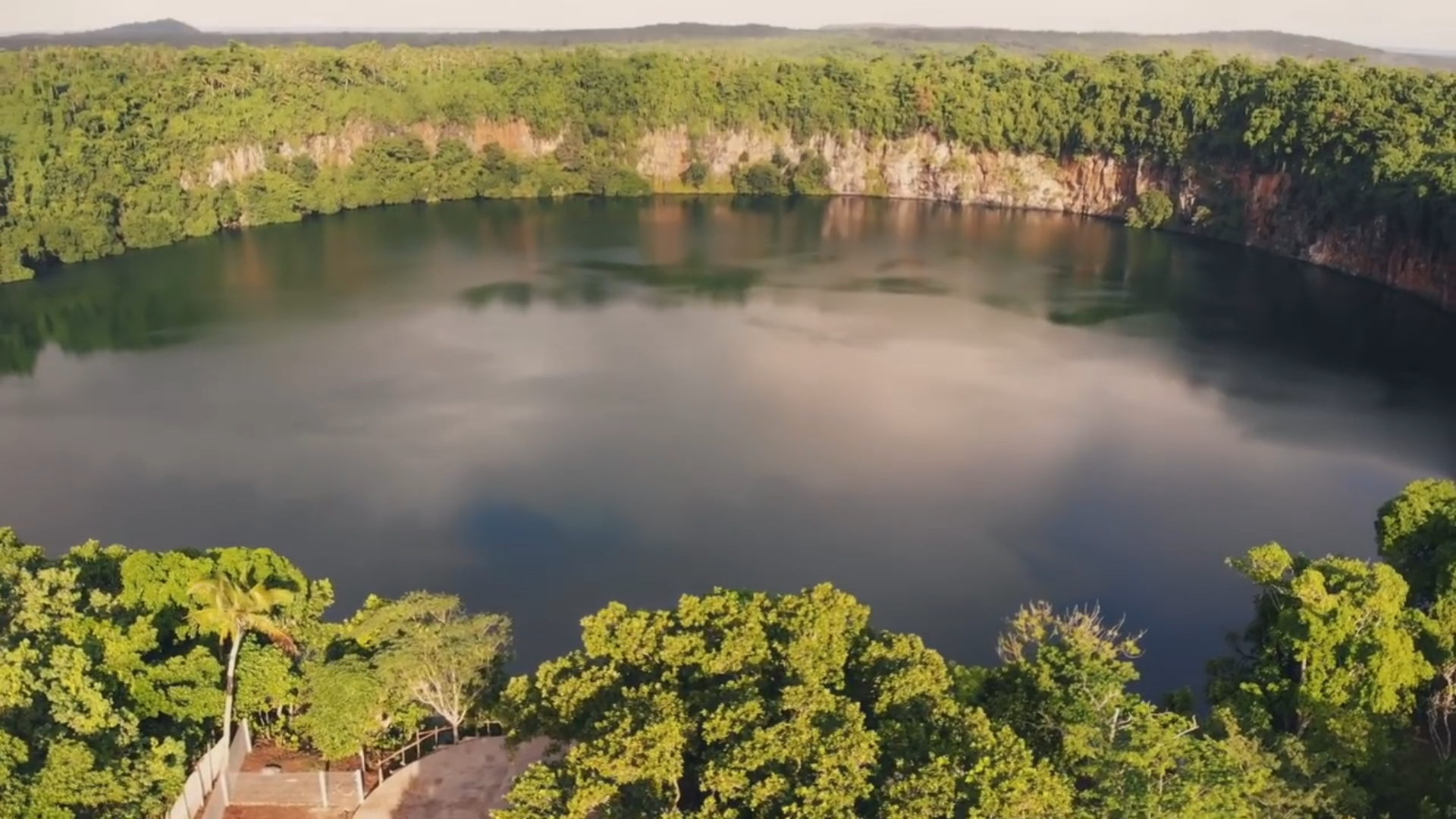
Why visit: Lake Lalolalo is one of the most striking landscapes in Wallis and Futuna. The lake forms an almost circular dark surface deep inside a volcanic crater, with tall slopes and thick greenery around the rim. The contrast with Wallis’s shallow turquoise lagoon makes it the perfect place to start a geographical tour: the same island contains both an enclosed inland freshwater environment and a reef-protected coastal system. The official tourism authority describes the lake as around 450 metres across and at least 80 metres deep, but those estimates should not be interpreted as a promise that visitors can walk down to its water.
Understand the deeper story: The forest that surrounds Lalolalo is known as vao tapu, a sacred forest. That classification carries cultural meaning and demands greater care than an ordinary park label. The tourism authority also describes unusual blind eels living in the lake, a reminder that isolated habitats can develop remarkable ecological characteristics. A visitor should not turn those rare organisms into a wildlife sighting guarantee or assume that they may be sampled, caught or photographed underwater. The lake’s circular outline is evidence of its geological setting, while its precise origin and ecological history require scientific study.
Practical visitor choices: The signed viewpoint is the appropriate visitor destination. Observe from designated barriers and keep children supervised near steep edges. Rain can make paths slick and low cloud can reduce visibility. Do not attempt to climb down, use a drone without local authorisation or enter sacred forest for a better photograph. A private taxi or rental car may be needed because Wallis and Futuna have no ordinary public-bus service. Check local access advice before travelling, and respect nearby community or landowner instructions even if a digital map shows an apparent shortcut.
Learning question: Sketch the lake as a cross-section, labelling the crater rim, slope, forest and water surface. Identify which elements you can observe from the viewpoint. Then explain why determining water depth or the age of a volcano requires instruments and verified research, not just a scenic photograph.
Return to the ten-place index · Next place
2. Talietumu and the Kolonui Tongan Fortress, Wallis
Why visit: Talietumu is among the most important archaeological places in Wallis. Its stone-walled and earthen features tell a story about political connections across the Pacific long before tourism linked island names on a world map. Visitors encounter a landscape associated with the period of Tongan influence over Uvea, not simply a decorative pile of old stones. The central sacred mound and surrounding structures invite questions about authority, movement, construction and the relationship between architecture and ceremony.
Understand the deeper story: The Wallis and Futuna tourism office explains that Kolonui Fort was built around Talietumu, a sacred elevated mound, by a lineage linked to Tonga. A careful account should distinguish this accepted historical-archaeological description from a claim that every feature has an exact known construction year. Stonework provides clues about labour and organisation, while oral histories, place names and comparative archaeology add layers of interpretation. The site also reminds visitors that Wallis retains a traditional chiefly and royal system; cultural authority here is not just a subject for an ancient-history display.
Practical visitor choices: Use recognised access arrangements and seek a knowledgeable local guide where available. Do not step onto a sacred mound, move stones, remove artefacts or turn a ceremonial site into an impromptu playground. Ground surfaces may be uneven, and there may be limited formal visitor facilities. This is a place for a quiet, unrushed visit rather than a hurried roadside stop. Take photographs only where permitted and ask how local tradition understands the site’s significance instead of assuming that an online description settles every detail.
Learning question: Create a simple plan showing the mound, visible stonework and pathways. Discuss why a community would invest labour in building a fortified or ceremonial complex, and record which explanations come from site interpretation rather than direct observation.
Return to the ten-place index · Next place
3. Mata Utu Cathedral and the administrative centre of Wallis
Why visit: The cathedral at Mata Utu belongs on this list because Wallis and Futuna is made of living communities, not empty natural landscapes. Its distinctive construction and town setting demonstrate the prominence of Catholic life alongside local traditions and public institutions. A visit through the public streets around Mata Utu can also reveal administrative services, businesses, shoreline orientation and the relationship between a central settlement and the wider Uvea lagoon.
Understand the deeper story: The territorial travel portal describes the cathedral’s walls as incorporating lava stone and coral, linking building technique directly to the island’s physical resources. Catholic missionary history is an important part of Wallis’s nineteenth-century social change, but it should not erase the existing spiritual, kinship and chiefly traditions of local residents. Public religious celebrations can be central to community identity without becoming performances arranged for visitors. A thoughtful tour compares the natural materials of a structure with the contemporary activities that keep it meaningful.
Practical visitor choices: This is an active worship environment. Check if visiting is appropriate, avoid entering during a service without permission, dress respectfully and leave the congregation space. Do not assume offices, chapels or adjacent community buildings are public museums. A street map may be enough for a self-guided exterior visit, but a local guide is useful for learning about the relationship between custom and formal government. Keep clear of roads and private properties when photographing the skyline or decorated buildings.
Learning question: Note one material visible in the cathedral and one civic service nearby. Explain how a religious building can function as both architecture and a place of present-day community practice, without reducing worship to an attraction.
Return to the ten-place index · Next place
4. Wallis Lagoon and its reef-fringed islets
Why visit: The lagoon around Wallis is a world apart from the deep water of Lake Lalolalo. A coral reef encloses much of the water around the island, and a series of small outer islets provides different views of coastal geography. Official tourism routes describe a dozen or more lagoon islets, with day trips, beaches, chapels, kayaking or snorkelling at suitable spots. The important point is not to count islets as trophies, but to choose an outing that respects local boat operations and the marine environment.
Understand the deeper story: A coral lagoon is the product of complex relationships between reef-building organisms, sea level, water movement and island geology. Small landforms within it may appear stable in photographs yet experience change after storms. Some islets contain religious buildings or community associations that call for respectful visiting. Tourism advertisements sometimes describe an islet as deserted, but that does not mean it is unowned or available for unapproved camping. Island culture and customary authority matter alongside marine biology.
Practical visitor choices: Arrange a locally operated boat transfer and confirm which islet is actually suitable for your date and interests. The tourism office notes that several islets have basic visitor facilities, but those differ and should not be assumed on every landing. Sea state, wind and the boat’s safe return period control an excursion; the reef does not eliminate all risk. Never stand on coral or remove living marine organisms, and avoid disembarking at a sacred or protected place without consent. If weather is unsuitable, enjoy a land-based lagoon view instead.
Learning question: On a simple map mark the main island, outer reef, lagoon, chosen islet and boat route. Explain why a ten-minute crossing can become unsafe or unavailable in changing conditions, even when the islet remains visibly close.
Return to the ten-place index · Next place
5. Uvea Museum Association and the American Occupation heritage route
Why visit: The museum and heritage route associated with the Uvea Museum Association offer a different kind of history from Talietumu. During the Second World War, American forces used Wallis as part of their Pacific infrastructure network. Roads, the airfield, wharves and other remnants transformed transport and helped change everyday contact with the outside world. Studying that period reveals why a remote island became important to military planners without pretending that residents were passive background figures.
Understand the deeper story: The territorial authorities describe the American presence between 1942 and 1946 and identify surviving infrastructure and exhibits recalling the period. Military engineers solved practical problems of landing, communications, roads and supply, but construction also affected land use and the community’s routine. The tourism office recommends contacting the Uvea Museum Association to organise a heritage route, noting that some remnants may still be visible. This helps visitors distinguish the authentic remains of an infrastructure site from a modern reconstruction or a structure whose purpose can no longer be established by sight alone.
Practical visitor choices: Contact the museum association before departure; do not assume exhibits or guided routes are staffed every day. Never enter an unmaintained bunker, an active airport or privately controlled infrastructure for photography. Coastal sites can be affected by erosion and weather, and historical objects should not be moved as souvenirs. Allow time to ask how older residents and community histories describe the wartime changes. A guided interpretation can also help place military sites in the wider chronology of traditional governance and later relations with France.
Learning question: Pick one wartime structure or artefact, then record what it was designed to do, what local effect it may have had and what primary source would be needed to confirm the claim. A road’s existence alone does not tell the full social history of its construction.
Return to the ten-place index · Next place
6. Lanutavake and Lano Crater Lake Landscapes, Wallis
Why visit: Wallis’s less famous crater lakes provide an essential companion to Lalolalo because a top-ten guide should explain variation rather than show ten versions of one famous landmark. The official tourism office identifies Lake Lanutavake, Lake Lano and Lake Lalolalo as three distinct crater lakes. Lanutavake and Lano do not need dramatic tourist infrastructure to be meaningful: comparing their settings can reveal different vegetation, catchment patterns and human uses of inland freshwater.
Understand the deeper story: The tourism authority explains that Wallis’s crater lakes are valuable freshwater reserves. That is not a trivial fact on an island surrounded by salt water. Rainfall, groundwater, volcanic formations and community management influence what freshwater is available for homes, gardens and natural habitats. Visitors should not presume that the water is drinkable simply because it appears clear, nor that swimming or fishing is permitted. A lake can also be culturally sensitive; customary rules are part of its present condition. Studying water resources provides a useful link between environmental science and public health.
Practical visitor choices: Unlike Lalolalo’s known lookout, access to Lano and Lanutavake should be arranged using current local advice rather than an improvised GPS path. There may be no formal signed viewing area, and vegetation, land ownership or conservation requirements may restrict entry. A local guide can explain whether a lawful public viewpoint is possible. Do not enter water, cross fences, remove plants or attempt aerial photography without permission. A visitor who cannot obtain access may use maps and official descriptions to understand these lakes remotely.
Learning question: Compare the three lake outlines on a map and draft a table of what is known, what can be observed from an authorised viewpoint and what remains unknown. Discuss why a freshwater reserve is not automatically a recreation facility.
Return to the ten-place index · Next place
7. Poï Basilica and the Saint Pierre Chanel pilgrimage landscape, Futuna
Why visit: On Futuna, Poï Basilica is one of the territory’s strongest places for understanding living faith. The basilica and its associated chapel commemorate Saint Peter Chanel, a Catholic missionary killed on Futuna in 1841 and canonised in 1954. The annual pilgrimage on 28 April draws worshippers from many Pacific communities. The site is best approached not as an exotic backdrop but as a place where the history of mission, local authority, religious devotion and personal memory remains active.
Understand the deeper story: A visitor should be careful about the historical setting. Conversion and missionary activity occurred within an existing Polynesian society with traditional leaders and systems of belief. A church guide may describe the saint’s life from a religious perspective, while historical scholarship may examine the same period using political and social sources. Both can be understood without treating the people of Futuna as an anonymous crowd. The basilica’s architectural scale and careful decoration illustrate the investment of local communities in public religious life.
Practical visitor choices: Arranging a visit to Poï is not the same as visiting a church along Wallis’s road network. Futuna requires its own inter-island flight reservation, accommodation and local transport. Check current worship times, festivals and permission before photographing indoors. If the annual pilgrimage is taking place, the needs of worshippers should come first. Respectful dress and quiet behaviour are appropriate, and there may be periods when tourists are asked not to enter particular spaces. Ask locally for a suitable time to understand the surrounding cultural landscape.
Learning question: Record the difference between the church’s architectural features and a story associated with the pilgrimage. Which could be established by directly observing the building, and which needs historical or religious testimony?
Return to the ten-place index · Next place
8. Mount Puke and Futuna’s mountainous interior
Why visit: Mount Puke is the highest mountain on Futuna and offers one of the strongest contrasts with the gentle outline of Wallis. The slopes rise steeply above river valleys, villages and cultivated land, and a guided hike can help explain why communities and roads are arranged so differently here. Travellers who love landscape observation may find the climb valuable, but it is not a general sightseeing stop suitable for everyone.
Understand the deeper story: The territory’s official travel portal emphasises Futuna’s mountain streams and terraces used for wet taro cultivation. These are examples of how people have adapted food production to local relief and water supply. A trail through changing vegetation can also reveal different environmental conditions at increasing altitude. The mountain belongs to a lived and culturally meaningful landscape rather than an empty wilderness. Distinguish a scientific explanation for a slope, an agricultural practice described by a guide and a community’s cultural understanding of the area; they answer different questions.
Practical visitor choices: Only experienced walkers should consider an ascent, and the territorial tourism office specifically recommends a local guide. Check rainfall and route conditions with the guide rather than relying on old distance estimates. Slippery vegetation, river crossings, heat and steep gradients can make an apparently short route exhausting. Carry water, suitable clothing and communication arrangements. If a person cannot manage the hike safely, a legal road viewpoint of the mountain and cultivated terraces remains a meaningful choice.
Learning question: Draw a simple elevation profile from village to mountain and label where you see terraces, forest and ridges. Explain why the easiest route does not always follow the shortest line on the map.
Return to the ten-place index · Next place
9. Anakele royal heritage site and Futuna’s historical landscape
Why visit: Anakele is one of Futuna’s important historical sites, identified by the tourism authority as connected with the burial of King Fakavelikele and the beginnings of the current Tui’Agaifo royal line. It offers a chance to understand the relationship between place, ancestry and customary authority. Such a site is not an ordinary archaeological ruin where visitors can wander wherever they choose. Its significance continues for people whose family and political traditions are linked to the location.
Understand the deeper story: Wallis and Futuna maintains three customary kingdoms, one on Uvea and two on Futuna, alongside French territorial institutions. That arrangement is unusual but should not be exoticised: it is a functioning feature of governance and community life. The official tourism account describes Anakele’s historical and natural setting, yet historical names and lineage stories are best understood with people who know the relevant oral tradition. The story of a royal burial should not be turned into a claim that outsiders may approach graves or sacred objects without consent.
Practical visitor choices: Seek information locally about whether a respectful guided visit is available. Do not enter fenced or sacred ground, touch funerary objects or stage photographs on a burial site. If visiting is not appropriate during a family or community event, accept the restriction. Weather and path surfaces still matter, so choose suitable shoes and ask about any accessibility issues. Learning from a guide’s explanation from an approved location is more respectful than attempting to reach a specific stone without permission.
Learning question: Compare an oral historical account with a mapped or written description. What different kinds of information do they preserve, and how could both inform a more careful interpretation of a culturally important place?
Return to the ten-place index · Next place
10. Alofi Island, Alofitai shore and Loka Cave
Why visit: Alofi lies close to Futuna but feels distinct from its settled neighbour. Its forest, offshore marine habitat, Alofitai beach and sacred Loka Cave attract travellers interested in nature and culture. The territory’s official tourism office presents a day visit by local boat and describes a forest walk to the cave. Alofi is sometimes called uninhabited in a statistical sense, but the tourism authority mentions a resident caretaker, and the island has customary connections. It should not be represented as ownerless wilderness.
Understand the deeper story: The route to Loka Cave combines the physical nature of a rocky coast with religious pilgrimage and stories passed through generations. Its environmental value includes vegetation and marine life that require protection. A remote beach can appear pristine while remaining sensitive to trampling, rubbish or unregulated camping. Distinguish the pleasant experience of looking at a shoreline from an assertion that the forest is scientifically untouched, and distinguish a sacred cave from a recreational swimming pool. Local leaders and guides are essential sources for understanding the place.
Practical visitor choices: Arrange a boat from Futuna with a locally authorised operator, verifying wind, sea state, landing conditions and safe return. A guide is strongly recommended for the forest and Loka Cave route. The path may be slippery, the shoreline rocky, and water levels near natural pools can change with tides. Do not enter the cave against community rules or forfeit safe passage by chasing a low-tide photograph. Take food and drinking water as advised, pack all waste out and respect flora, fauna and religious spaces.
Learning question: Make a three-part comparison of boat transport, forest path and sacred cave. For each, name one physical hazard, one cultural responsibility and one observation supported by the territory’s official descriptions.
Return to the ten-place index · Plan a thoughtful visit
Plan the islands separately, not as one road itinerary
A stay based on Wallis can bring together Lake Lalolalo, Talietumu, the Mata Utu area and the American Occupation heritage route, while reserving a separate day for a properly organised lagoon-islet outing. Weather, opening hours and customary access rules will affect the sequence. The two smaller crater lakes are best included only when current local guidance identifies lawful viewing arrangements; they are not a promise of formal tourist facilities.
Futuna deserves a separate plan. Its mountainous relief, smaller transport network and living religious sites are markedly different from Wallis. The tourist office describes the Wallis-to-Futuna connection as a short flight operated by small aircraft, generally six days a week with limited seating and reservations managed locally. Flights can change, so accommodation and transport must be confirmed before you build a route around Poï, Mount Puke or Alofi. There is no ordinary inter-island ferry to substitute at the last minute.
The essential transport, culture and safety checklist
- Check Aircalin or a local territory travel agency for international access to Wallis and locally arranged flights to Futuna. A timetable on an older webpage is not a confirmed seat.
- Arrange a legal rental vehicle or known driver on the island you are visiting; ordinary public buses and taxis are not generally available according to the official tourist office.
- Respect customary ownership and village authority. Ask before entering sacred forests, historical mounds, burial places or worship spaces, and accept a refusal without argument.
- Use recognised boat operators for lagoon islets and Alofi. Sea state, wind, tides and a safe return period take priority over a promotional photograph.
- Bring water, appropriate clothing and a local guide for demanding Futuna hikes. Strong rain can make forest paths and streams dangerous.
- Leave fragile archaeological stones, cave deposits, corals, freshwater resources and protected wildlife undisturbed.
- Keep direct observation separate from local oral accounts and academic or museum interpretation; all matter but they are different kinds of evidence.
Three itineraries worth considering
For a relaxed introduction to Wallis, choose the Lalolalo lookout, a museum or guided heritage stop, and a respectful walking visit to Mata Utu. For a deeper cultural programme, spend more time at Talietumu and the American Occupation sites with qualified interpreters, rather than adding extra beaches. For Futuna, reserve enough days to learn about Poï and Anakele and consider the Mount Puke or Alofi outing only when local guides and conditions permit. No traveller needs to enter every sacred site or climb every hill to have an enriching trip.
Frequently asked questions
Are Wallis and Futuna connected by a ferry?
No ordinary scheduled passenger ferry connects them, according to the territory’s tourism information. The usual connection is a small domestic flight that must be booked locally.
Can I drive directly from Wallis to Futuna?
No. These are geographically separate island groups, so visitors need an inter-island connection and separate local transportation arrangements.
Can anyone swim in Lake Lalolalo?
The official tourist experience is a lookout over a sacred, steep-sided crater lake. Do not treat it as a swimming spot or attempt to descend without authorised guidance.
What makes Talietumu important?
It is an archaeological and sacred site associated with a Tongan-era fortified complex on Uvea. Its meaning includes political history and living customary traditions.
Does Alofi have a large resident town?
No. The tourism authority describes it as effectively uninhabited, while noting a resident caretaker. That does not mean the island lacks ownership, customary rights or entry rules.
Is the Mount Puke hike suitable for families with young children?
It is a demanding mountain route recommended for experienced walkers with a local guide, not an easy family promenade. Suitable lower-altitude viewpoints may be preferable.
What are the three traditional kingdoms?
Uvea is the traditional kingdom on Wallis. Futuna has the customary kingdoms of Sigave and Alo, alongside the institutions of the French overseas collectivity.
When is the pilgrimage at Poï?
The major annual remembrance of Saint Peter Chanel takes place around 28 April. If visiting during ceremonies, worshippers’ needs and the local community’s directions come first.
Turn an island trip into evidence-based learning
A useful travel notebook separates three kinds of understanding: a detail you directly see, an interpretation provided by a trustworthy source and a question you cannot answer yet. At Lalolalo you can observe the outline of the crater; to establish its depth you need measurements. At Talietumu you can see stonework; the cultural and historical interpretation depends on archaeology and oral traditions. At Poï you can observe architecture while understanding the pilgrimage through religious and community accounts.
For Mathematics and Geography practice, compare the straight-line separation of Wallis and Futuna with the real travel steps: booking a small aircraft, reaching the departure airport, arriving and arranging a local vehicle. Ask why a journey can take longer than a map’s straight line suggests. The same habit of checking assumptions and presenting complete reasoning is illustrated in eduKate’s Secondary 1 Mathematics Tutor Clementi | Small Groups Tutorials.
Explore the companion Wallis and Futuna articles
Top 10 Things to Do When Visiting and Touring Wallis and Futuna · Top 10 Things to Learn When Visiting and Touring Wallis and Futuna · World Country Directory
Official sources and photo attribution
References reviewed 18 October 2026, Singapore time. Background information is not a live seat reservation, boat service or access permission; current tourism-office and customary-community instructions take precedence. The opening photograph is a licensed 2018 image and is not evidence of today’s condition.
- Wallis and Futuna Tourism Office — official must-do places
- Wallis and Futuna Tourism Office — suggested tours
- Wallis and Futuna Tourism Office — Discover Wallis
- Wallis and Futuna Tourism Office — practical transportation details
- Wallis and Futuna Tourism Office — official attractions in French
- Territorial administration — travel, governance and heritage
- Territorial administration — islands’ travel context
- Wikimedia Commons — Lake Lalolalo photo, LymLog, CC BY 3.0
- Creative Commons — Attribution 3.0 Unported licence