
What are the top ten places to visit on Wangerooge? Start with the Old Lighthouse and Inselmuseum, then enjoy the narrow-gauge island railway, the Upper Beach Promenade and the main sandy beach. Rosenhaus National Park Centre explains the Wadden Sea; in the west, Westturm, the modern New Lighthouse and the Ehrenfriedhof reveal different layers of history. In the east, the Jever viewing platform and the remains of the old eastern landing stage connect protected marshes with changing transport routes. These ten stops form an achievable guide for a car-free North Sea holiday.
Wangerooge is one of the seven inhabited East Frisian islands in Germany, with a ferry from Harlesiel and a connecting island railway from the western landing pier to the village. The conventional combined journey is around ninety minutes, though the actual departure depends on tide and weather. A two- or three-day stay allows time for the western towers and eastern nature views without rushing. Day visitors should focus on the village, museum and nearby beach.
13 November 2026 update: The New Lighthouse is an operational landmark with no interior visitor access. The Old Lighthouse has a museum and observation platform, subject to published openings. The Rosenhaus National Park Centre has a reduced winter schedule but is described by the municipality as open year-round, with free entry. The Jever platform’s adjacent southern saltmarshes must not be entered at any time. The ferry and railway use weather- and tide-aware schedules; check the current operator notices.


The ten Wangerooge places at a glance
- 1. Alter Leuchtturm: Old Lighthouse and Island Museum — Historic beacon, island museum and a possible tower panorama.
- 2. Island Railway from the Western Ferry Harbour — Tide-aware ferry, saltmarsh railway and everyday transport.
- 3. Obere Strandpromenade and Café Pudding — Sea views, historic resort culture and a distinctive island café.
- 4. Main Wangerooge Beach and the Protected Dunes — Family beach time, North Sea environment and safe swimming decisions.
- 5. Rosenhaus National Park Visitor Centre — Wadden Sea ecology, bird migration and freshwater learning.
- 6. Westturm: Wangerooge’s Western Tower — Tower silhouette, youth-hostel heritage and a west-island outing.
- 7. Neuer Leuchtturm: The Modern Western Lighthouse — Modern navigation, radar and large-vessel shipping.
- 8. Ehrenfriedhof and the Memory of 1945 — Solemn wartime remembrance and the island’s reconstruction.
- 9. Jever Viewing Platform and the Eastern Saltmarshes — 360-degree view, maritime channels and protected bird habitats.
- 10. Former Eastern Landing Stage and Its Railway History — Historical ferry routes, coastal sediment and changing transport networks.
The attractions are grouped by geography, not listed as a route to finish in a few hours. The old lighthouse, village station, beach and Rosenhaus form an easy central cluster. Westturm, the New Lighthouse and Ehrenfriedhof belong to a west-island day; the Jever platform and former east pier are a separate eastern nature-and-history outing. You may enjoy the island most by choosing fewer destinations and taking time for the sea and ordinary village life.
Quick recommendations for different travellers
- First visit: Old Lighthouse exterior or museum, island railway, promenade and a short beach walk.
- Families: Rosenhaus exhibits and suitable beach access rather than a long exposed trail.
- History: Old Lighthouse, Café Pudding’s transformation, Ehrenfriedhof and former east pier.
- Navigation: Compare Old and New Lighthouses, recognising different access rules.
- Nature: Jever viewing platform, guided Wadden Sea excursions and legal dune paths.
- Cycling: Choose a short east or west ride based on weather and bring a helmet.
- Winter: Confirm ferry, railway and Rosenhaus hours before leaving Harlesiel.
1. Alter Leuchtturm: Old Lighthouse and Island Museum
Where: Zedeliusstraße 3, central Wangerooge. Main interest: Historic beacon, island museum and a possible tower panorama.
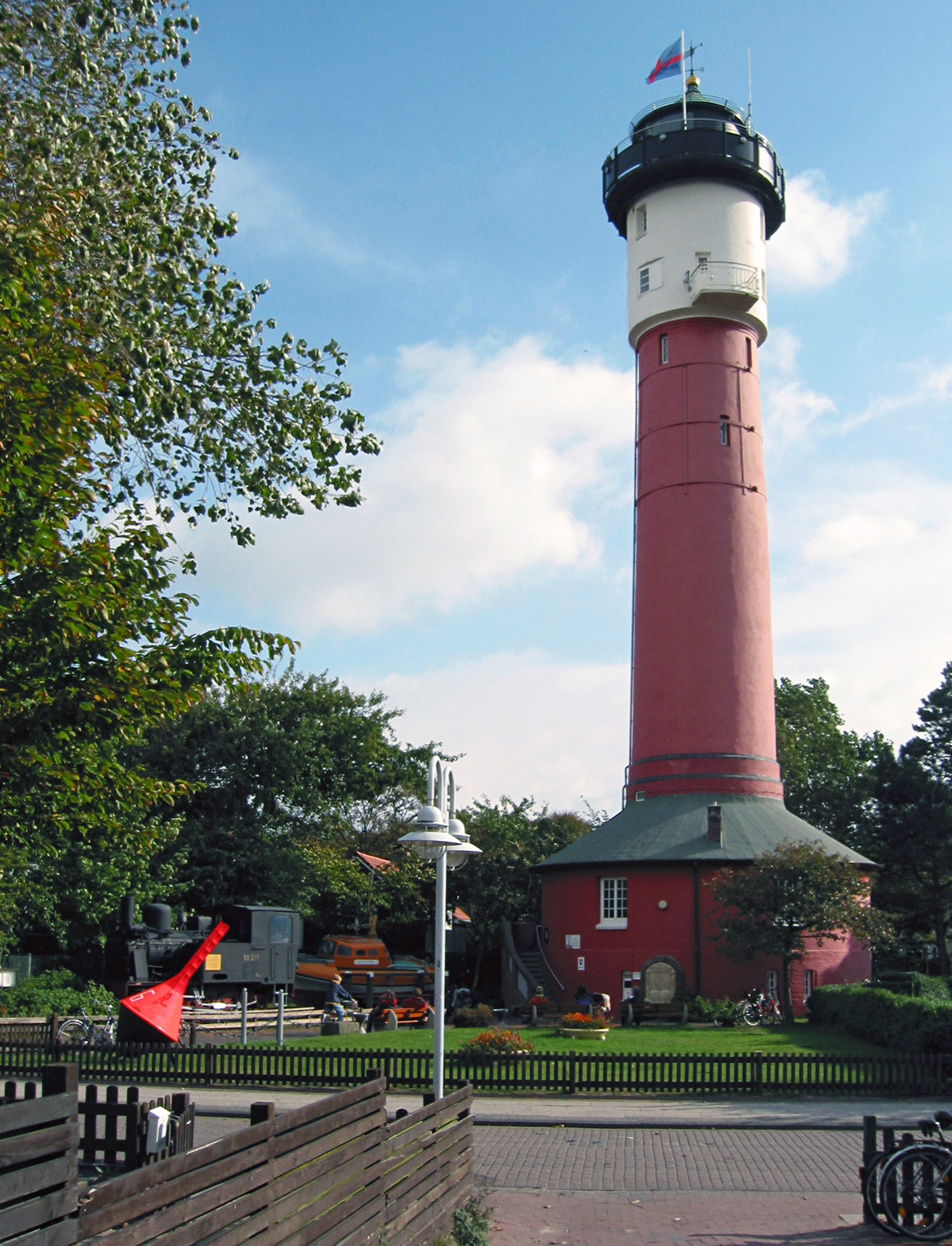
The Old Lighthouse is one of Wangerooge’s defining landmarks and a natural beginning for visitors interested in the island’s history. Its red tower and dark lantern rise above the village rather than standing on a lonely headland. The beacon served shipping until 1969, when its role changed; the municipality then acquired it and developed it as a museum and viewing point. Its exhibits provide context on island settlement, maritime navigation, storms and the changing shape of the coast. A lighthouse in the middle of a village can appear unusual to someone used to pictures of towers at the water’s edge, but coastlines and settlements move while structures remain. That makes the building an excellent introduction to the island’s relationship with history and geography.
The museum and observation platform have separate practical considerations from the exterior, which can be seen on a town walk. Check current museum and climbing hours with the visitor service before promising a tower ascent, especially outside the main season. Stairs, narrow spaces and height may make the climb unsuitable for some people; a historic building should not be advertised as universally accessible. If a service or special event is scheduled, public access may differ. Treat the collection carefully and ask before using flash or handling artifacts. The village setting lets a family enjoy a brief exterior stop even when admission is unavailable.
The educational question is why an island needed multiple different lights over time. Wangerooge’s Old Lighthouse, New Lighthouse and Westturm did not all serve the same purpose. Navigation requires clear signals at locations appropriate to vessels and channels, and technology changes. Ask what can be learned by observing a historic tower and what needs an official historical source. A photograph from 2006 shows appearance, but not current museum opening, structural access or weather.
Route suggestion: Combine with the island station, the main village and nearby Rosenhaus. Make the tower climb optional rather than an obligation for children or visitors with limited mobility.
Back to all ten places · Next place
2. Island Railway from the Western Ferry Harbour
Where: Western ferry harbour to Wangerooge Inselbahnhof. Main interest: Tide-aware ferry, saltmarsh railway and everyday transport.
For many visitors, Wangerooge’s island railway is the first memorable experience after disembarking. The ferry reaches the island’s western harbour, and a narrow-gauge train takes passengers across the lower landscape into the central village. The journey passes saltmarshes and views of a lagoon associated with the Lower Saxony Wadden Sea National Park. The official tourism service describes a gentle train speed around twenty kilometres per hour, turning what might be ordinary onward transport into a scenic introduction. Yet the railway is not a toy sightseeing ride invented solely for tourists. It links a real harbour to an inhabited town and helps residents, businesses and visitors navigate a car-free island.
The mainland ferry departs from Harlesiel near Carolinensiel. Its departure changes with water levels, and the combined ferry-plus-rail journey is described as approximately ninety minutes under normal conditions, including a train ride of roughly fifteen to twenty minutes. The timetable is weather-dependent; check both legs with Schifffahrt und Inselbahn Wangerooge (SIW) and follow the baggage arrangements. Do not assume you can arrive at the western harbour and drive to accommodation in a taxi. Ordinary private motor traffic is prohibited; essential service vehicles may have special permissions. Find the correct train platform for the return and leave time for check-in.
A good family activity is to identify what needs to work for this journey: a ferry, a harbour, a railway, tracks, drivers, baggage handling and safe communication. If one connection changes, the whole trip can be affected. The quiet car-free village depends on highly organised transport outside it. The scenery also helps show why saltmarshes are protected: birds feed and rest in habitats that can be disturbed by people leaving permitted areas. Watch from the train rather than stepping into sensitive marshland for a photograph.
Route suggestion: Enjoy as part of arrival, not as a separate excursion. Plan return travel from Inselbahnhof rather than using the ship time alone.
Back to all ten places · Next place
3. Obere Strandpromenade and Café Pudding
Where: Main north coast above the village beach. Main interest: Sea views, historic resort culture and a distinctive island café.
The Upper Beach Promenade offers Wangerooge’s classic resort perspective: a walkway beside the dunes, a view across the North Sea and the possibility of a relaxed café stop. Café Pudding is one of the island’s most distinctive buildings, perched on a dune and associated with a wartime bunker later converted to an ice-cream stand and then a café. Its unusual history makes the experience richer than simply taking a photograph of a famous building. The surrounding promenade also reflects the development of Wangerooge as a holiday and health resort. This is a place where tourism infrastructure, cultural memory and a dynamic sandy coastline meet.
Choose a leisurely public promenade route and check whether Café Pudding is open on your particular day; coastal businesses may reduce hours during November. The view is rewarding without requiring a meal or reservation. Remain on public paths and avoid informal shortcuts down fragile dune slopes. Weather can change quickly and a gentle-looking elevated walkway may feel exposed in high wind. For mobility needs, consult current information about the accessible promenade and beach entrances rather than assuming every staircase has an easy alternative. Children should be supervised near steep dunes or access ramps.
Café Pudding offers a useful question about adaptation. How can an old military structure change into a public leisure space, and what does that tell us about a community’s history? Buildings may be repurposed when their original function disappears, but the wider social story remains important. Observe the contrast between the maintained walkway and the natural sandy beach below, which changes with tides and storms. The view can be both beautiful and an introduction to resilience, maintenance and changing land use.
Route suggestion: Pair with the main beach, village shops and a short cultural museum visit. Make it the restful centre of a first afternoon.
Back to all ten places · Next place
4. Main Wangerooge Beach and the Protected Dunes
Where: North-facing bathing beach beside the resort village. Main interest: Family beach time, North Sea environment and safe swimming decisions.
Wangerooge’s main sandy beach draws visitors who want open sea air, long walks and the feeling of being surrounded by water and sky. Summer brings beach chairs, designated bathing areas and a busy holiday rhythm, while autumn and winter can offer peaceful sand and dramatic cloud shapes. The beach is not simply a flat recreational surface. Waves move material along the shore, tides alter its exposed extent and dune vegetation helps stabilise the land behind it. Understanding these processes makes a seemingly simple coastal afternoon much more interesting, and it explains why visitors are directed to particular entrances and activity zones.
The official visitor service says that supervised bathing fields are provided at the main beach and in the west during the appropriate season, but their staffing must be confirmed for the actual day. Do not expect lifeguards, overnight beach chairs or a beach bar to operate in November because they appear in a summer photograph. Choose authorised beach accesses, observe flags and supervise children near waves and changing channels. Walking across delicate grasses to reach a quieter part of the shore weakens the dunes over time. Beach chairs and unusual sleeping beach-chair offers are seasonal products, not permanent facilities.
The beach is a practical lesson in what maps leave out. A map gives a convenient coastline, but the waterline changes through the day. Ask how wind creates ripples and how grass roots catch sand. Compare a bare stretch of beach with a vegetated dune, then consider why an island community invests in protecting those areas. A short walk can be educational without requiring shell collecting or off-path exploration. The best experience respects the coast and the people sharing it.
Route suggestion: Use as a relaxed family afternoon with the promenade. If conditions are cold or rough, enjoy the sand from a permitted viewpoint rather than swimming.
Back to all ten places · Next place
5. Rosenhaus National Park Visitor Centre
Where: Friedrich-August-Straße 18, Wangerooge village. Main interest: Wadden Sea ecology, bird migration and freshwater learning.
The Nationalpark-Haus Rosenhaus is an excellent place for first-time visitors to learn why the Wadden Sea matters. Its exhibitions cover the transnational UNESCO natural World Heritage property, coastal wildlife, migrating birds and the challenge of obtaining drinking water on a sandy island. It is valuable for families because much of the life of the mudflats is hidden underground or under water, and interpretation makes that ecosystem more understandable. The centre gives visitors a scientific framework for what they later see from a beach, railway window or marked viewpoint. It also helps separate a protected nature area from a place that is simply open to recreation.
The local municipality describes Rosenhaus as a free, accessible and year-round visitor centre, although specific hours and programmes differ by season. The published seasonal guide distinguishes a main season ending on 31 October and a reduced period beginning 1 November. Confirm the current timetable, and do not assume a booked mudflat walk is included with the exhibition. Winter indoor introductions may be offered on selected days, while outdoor activities depend on tide and weather. The centre is a better place to ask about actual routes than an old map copied from another travel blog.
Ask why birds stop along the Wadden Sea during migration. Exposed mudflats reveal food-rich sediment, while saltmarsh and dunes provide different habitats. A single bird sighting is interesting, but the conservation significance emerges from many animals using the area across seasons. Another excellent question is how freshwater can be protected on an island surrounded by salty water. The exhibitions connect biology, geography and engineering without promising that every visitor will see a rare species outdoors.
Route suggestion: Visit before an authorised guided walk, or use as a weather-flexible museum alongside the Old Lighthouse and village.
Back to all ten places · Next place
6. Westturm: Wangerooge’s Western Tower
Where: Western island, Straße zum Westen 46. Main interest: Tower silhouette, youth-hostel heritage and a west-island outing.
The Westturm is one of Wangerooge’s most recognised silhouettes, standing in the west near the New Lighthouse. The present tower is a twentieth-century structure associated with the history of earlier western towers, navigation and community change. Today the building houses a youth hostel rather than an always-open public lighthouse museum. This distinction matters: a structure may be listed as a sightseeing landmark while its rooms serve overnight guests and booked groups. The appeal is to appreciate the landmark in the context of the western island landscape, with dunes, paths and a broader view of how the island’s coastline has shifted over centuries.
Reach the area by an authorised western island path or cycle route and respect the youth hostel’s private accommodation spaces. Do not climb stairs or enter rooms simply because the structure is a famous landmark. If you have arranged hostel accommodation or a specific guided event, follow that provider’s instructions. The west can be windier than the sheltered village, and a longer ride needs daylight, water and appropriate clothing. Bicycle hire is possible on Wangerooge, but the island tourism website notes that local rental firms do not lend helmets, so bring appropriate protective equipment if cycling.
Ask why a striking tower has changed roles over time. Navigation, defence, accommodation and tourism may all involve buildings placed near important routes, but their social purposes differ. Compare the Westturm with the Old Lighthouse museum and the New Lighthouse, which continues to support navigation but does not admit ordinary interior tours. The contrast is useful for children learning that a building’s appearance does not fully explain its function. Checking what is open is part of understanding a place accurately.
Route suggestion: Pair with the New Lighthouse and a permitted western viewpoint as one dedicated half-day, not a short add-on to the far eastern dunes.
Back to all ten places · Next place
7. Neuer Leuchtturm: The Modern Western Lighthouse
Where: Western Wangerooge near Westturm. Main interest: Modern navigation, radar and large-vessel shipping.
The New Lighthouse is the second great western tower, standing near Westturm and playing a different role from the Old Lighthouse museum in the village. Official Wangerooge information describes a tower around sixty metres high and notes that its navigation system combines radar technology and guiding lights for ships approaching major sea routes. The position is important because the waterways of the German Bight connect vessels to major ports, including those around the Jade. The lighthouse is therefore part of real maritime infrastructure, helping explain why the island is more than a beach destination.
The current tourist service explicitly states that the New Lighthouse has no interior visitor access. Treat it as an exterior viewpoint and navigation landmark; do not advertise climbing, observation decks or hidden interior tours. Remain on public routes and avoid operational or fenced areas. A western cycle ride can make the journey pleasant in suitable weather, but a tired family should not attempt it late in the afternoon after the full eastern trail. If the sky is grey or wind strong, the silhouette can still be interesting from a safe, short permitted path.
A practical learning question is what different navigation technologies do. A light may provide a visible point of reference, while radar and communications systems help vessels identify positions or traffic under different conditions. Each requires reliable power, maintenance and professional operation. The New Lighthouse is an example of a useful facility that visitors should appreciate from outside without demanding access to its working equipment. Together with the Old Lighthouse and Westturm, it explains how different generations organised navigation and island life.
Route suggestion: Combine with Westturm and a west-island viewing platform; leave the inside of this operational tower entirely off the itinerary.
Back to all ten places · Next place
8. Ehrenfriedhof and the Memory of 1945
Where: Westward footpath from Wangerooge village. Main interest: Solemn wartime remembrance and the island’s reconstruction.
Wangerooge’s Ehrenfriedhof is a place of memory rather than recreational sightseeing. During the final weeks of the Second World War, the island was heavily bombed on 25 April 1945 after being militarised as a defensive position. Hundreds of people lost their lives, and residents, military personnel, forced labourers and other victims experienced suffering and destruction. A memorial cemetery was established after the war, and the island has continued to hold commemorations. This history should not be reduced to dramatic aircraft figures or the thrill of old bunkers. The cemetery is important because it invites visitors to acknowledge individual human consequences and the long work of rebuilding a community.
Approach quietly along the authorised footpath and treat gravestones and memorials respectfully. Do not photograph mourners or step onto graves to improve an image. If visiting with children, use age-appropriate language focused on remembrance and why societies preserve places connected with loss. The memorial is not a museum with a ticket and opening guarantees, and private ceremonies take priority. A short visit can provide context before continuing along the western path, but the tone should remain considered. Avoid claiming the entire island’s wartime story can be understood from a single marker.
Ask what historical evidence can tell us and where interpretation begins. Records identify the attack, its timing and its consequences, while photographs show aspects of destruction and memorials reveal how later generations chose to remember. The island’s postwar development included replacing buildings and adapting former military facilities, including the structure that became Café Pudding. History here connects to community resilience, responsibility and the way remembrance shapes public spaces. Respectful travel includes knowing when a place is not intended for amusement.
Route suggestion: An optional reflective stop on a western walk; avoid combining it casually with noisy leisure activities without recognising its purpose.
Back to all ten places · Next place
9. Jever Viewing Platform and the Eastern Saltmarshes
Where: Straße zum Osten, eastern Wangerooge. Main interest: 360-degree view, maritime channels and protected bird habitats.
The Jever-Plattform is a useful destination for travellers who want a panoramic impression of the eastern island without entering sensitive habitats. Official visitor interpretation describes a 360-degree view over beach, dunes, Wadden Sea and the Ostaußengroden saltmarshes. These surroundings are especially interesting because they show several habitats at once. The landscape can seem empty from a distance, yet saltmarsh plants, birds and tidal channels depend on limited disturbance. A viewing platform allows people to enjoy the geography and watch boats that may settle on the mud at low water while remaining in a safer public position.
The official island story is unusually clear about protection: the outer saltmarsh area south of the path must not be entered at any time of year. Stay on signed routes, give wildlife room and do not shortcut across vegetation. A bike or walk from the village can be rewarding in suitable weather, but be prepared for wind, sand and the return distance. The platform was made possible by the Jever brewery in 2007, though its name does not imply a sponsored service or any obligation to buy something. The viewpoint may offer a picnic spot, but do not leave litter or assume there are toilets or cafés at the end of the route.
An excellent observation exercise is to separate the habitats seen from one place: beach, dunes, saltmarshes and tidal flats. Ask why different plants and birds prefer each area. If a boat lies on the exposed seabed, explain how tides can temporarily remove the water beneath it. This can lead to a discussion about why earlier ferry docks became difficult to use as sediment accumulated. The same physical processes that create habitats influence human routes and transport.
Route suggestion: Use with the former eastern landing stage from authorised viewpoints; do not cross protected saltmarshes to reach relics.
Back to all ten places · Next place
10. Former Eastern Landing Stage and Its Railway History
Where: Eastern island shoreline visible near the Jever platform. Main interest: Historical ferry routes, coastal sediment and changing transport networks.
Wangerooge once had an eastern landing stage as well as the western ferry harbour used today. The eastern pier was built in 1903, and an island railway connection linked it with the village. It became particularly useful at certain periods but declined as shipping routes and sediments changed. By the late 1950s it was abandoned as a regular landing facility. Today remains such as timber piles can sometimes be seen from authorised viewpoints near the eastern shore. The story is valuable because it makes coastal evolution visible: infrastructure can become obsolete when water depths, traffic patterns and surrounding geography change.
This is a historical landscape, not an active ferry station or an excursion where visitors should walk to the old pilings. Keep to public paths and the Jever viewpoint; the adjacent saltmarshes are protected year-round and the tidal shore can contain hazardous ground. Do not climb old wood, approach exposed structures at low tide or assume there is a safe route to the former pier because its position is shown on a map. There is no modern passenger embarkation here. For an ordinary return journey, use the official western island railway and ferry arrangements.
Ask how people decide where to build a ferry terminal. Safe water depth, channel location, transport demand and maintenance costs all matter. An eastern pier that once served the island could become unsuitable as the surrounding environment and patterns of travel changed. Compare this with the working railway through the western saltmarshes today. The example shows that transport solutions must adjust to nature rather than assuming a route can be frozen forever. It is a fascinating place to think about engineering without having to enter restricted areas.
Route suggestion: Pair with Jever-Plattform as one eastern history-and-nature outing, with no independent crossing to the old structure.
One-, two- and three-day Wangerooge itineraries
One day: a relaxed central island introduction
A one-day trip depends on the exact Harlesiel ferry and return train. Begin with the picturesque island-railway arrival and walk from Inselbahnhof to the Old Lighthouse. If its museum is open, spend time there; otherwise appreciate the exterior and continue to the main village streets. The Upper Beach Promenade and Café Pudding make an appealing lunch or afternoon route. Enjoy a suitable beach section, then return to the station with enough time for the connected train and ferry. Do not attempt both far east and west in a short visit.
The railway connects the western harbour to the village, so the return departure from the town station matters in addition to the boat’s sailing time. If a child or older family member needs a quieter day, the heritage tower, café and beach already make a complete visit. Bad weather can be handled with a Rosenhaus exhibition rather than a forced long bike ride. A realistic route is the one you can enjoy without spending the afternoon checking how many kilometres remain.
Two days: village, then western landmarks
On the first day, explore the town, Old Lighthouse, Rosenhaus and promenade. A short supervised beach outing may complete the afternoon. On day two, choose a suitable bike or walking route towards Ehrenfriedhof, Westturm and the exterior of the New Lighthouse. Allow time for a calm memorial visit and do not advertise the operational tower as climbable. A permitted western viewing point can provide a better conclusion than a rushed return in strong wind.
Three days: add the Jever platform and eastern history
Use an additional day for the Jever viewing platform and the old eastern landing-stage story. The main reward is an uninterrupted view across beach, dunes, marsh and tidal water, not reaching every possible end of a trail. The saltmarsh south of the path is closed to visitors all year; keep to marked routes and use binoculars for birds. A locally guided excursion, when offered and suitable, can add depth to the nature day. Keep the third day flexible in case wind or rain makes the exposed route less appealing.
Getting to Wangerooge and travelling without ordinary cars
Schifffahrt und Inselbahn Wangerooge operates the conventional Harlesiel ferry and its narrow-gauge train connection to the village. The mainland harbour is near Carolinensiel and has parking and onward links, but these need their own planning. The ferry runs through tide-sensitive channels and the schedule can change with weather or operational conditions. The island’s western landing harbour is not the village itself; passengers normally board the connecting train, which moves slowly through saltmarsh scenery. The combined journey is usually around ninety minutes. Do not use a generic ‘ferry to East Frisia’ ticket without identifying the correct island and operator.
Ordinary tourist cars are not admitted to Wangerooge. Residents and necessary services have regulated arrangements, while walking and cycling serve most visitors. Wangerooge’s official bicycle page lists rental operators but warns that they do not rent bicycle helmets. Bring suitable protective equipment and choose routes that fit wind, traffic sharing and family abilities. A tide-dependent ferry can create a very different travel rhythm from a mainland train. Reserve the return, check luggage handling and ask the accommodation provider how to reach the room from the island station.
The Wadden Sea and why its protected habitats matter
The Wadden Sea is a transnational UNESCO natural World Heritage property shared by Germany, the Netherlands and Denmark. Wangerooge belongs to the Lower Saxony Wadden Sea National Park, which protects tidal flats, saltmarshes, dunes and wildlife. These habitats are not all freely accessible simply because they appear as open land at low tide. The official Jever-platform interpretation specifically prohibits entry to the saltmarsh south of the path throughout the year. Follow these boundaries, keep dogs controlled and do not cross fragile plants for a closer view of birds.
Tidal water can return through channels and soft sediment can make independent mudflat walking dangerous. Book a trained local guide for any extensive intertidal excursion, and understand that the tide, weather and participant abilities determine the route. Binoculars and safe viewing platforms are excellent alternatives. Rosenhaus can explain why birds use the Wadden Sea as a migration stop and why the island’s freshwater supply deserves protection. A thoughtful visitor learns to appreciate nature without insisting on entering every sensitive area.
History, remembrance and how buildings change roles
Wangerooge’s island buildings show several kinds of change. The Old Lighthouse became a heritage museum and lookout when its original navigation role ended. Café Pudding grew from a former wartime bunker into an everyday leisure landmark. Westturm became associated with youth-hostel accommodation, while the New Lighthouse is a working technical facility with no public interior. The former eastern pier illustrates how erosion and sediment can make a once-important harbour obsolete. These contrasts reveal a community adapting infrastructure and places over generations rather than merely preserving an unchanged seaside scene.
The Ehrenfriedhof adds a necessary solemn chapter. The island was bombed near the end of the Second World War, causing considerable loss of life. Memorial sites require quiet, respectful engagement, not sensational stories or casual posing. The experience becomes more meaningful when travellers understand that present-day beaches, cafés and schools exist alongside memories of destruction and reconstruction. History is not an interruption to a holiday; it helps explain why the island looks and functions as it does today.
Families, accessibility and seasonal expectations
Wangerooge can offer a relaxed family holiday because ordinary cars are restricted and much of the central village is walkable. Nonetheless, the long eastern and western routes require time, while sandy dune crossings, historical tower stairs and exposed weather may not suit every person. The Rosenhaus centre is described by the municipality as fully accessible, but always check an individual need rather than assuming every beach path and monument is barrier-free. A short museum visit plus a gentle promenade walk often works better for young children than a long coast-to-coast itinerary.
In November, the sea may be cold, days are shorter and some visitor services have reduced hours. The New Lighthouse remains an exterior landmark rather than a seasonal climb. Museum opening, outdoor tours and restaurant availability must be checked separately. Pack layers, water and a realistic return plan. A cancelled guided excursion or closed viewpoint need not ruin a day; the village, interpretation centre and safe coastal views offer good alternatives. Quality travel is about choosing what works on the actual day.
English–Chinese learning vocabulary for Wangerooge
- island — 岛屿 — dǎoyǔ
- lighthouse — 灯塔 — dēngtǎ
- island railway — 岛上铁路 — dǎo shàng tiělù
- harbour — 港口 — gǎngkǒu
- tidal flat — 潮滩 — cháotān
- saltmarsh — 盐沼 — yánzhǎo
- sand dune — 沙丘 — shāqiū
- nature reserve — 自然保护区 — zìrán bǎohùqū
- bird migration — 鸟类迁徙 — niǎolèi qiānxǐ
- memorial — 纪念碑 — jìniànbēi
- navigation — 航海导航 — hánghǎi dǎoháng
- historical evidence — 历史证据 — lìshǐ zhèngjù
Use a few words at the appropriate stop: ‘navigation’ beside the new lighthouse, ‘saltmarsh’ at the Jever viewpoint, and ‘island railway’ as the train reaches the village. At each location, observe what you can see, propose an explanation and check it against reliable interpretation. This supports accurate understanding without turning a holiday into an exam.
Frequently asked questions about Wangerooge
Where is Wangerooge?
Wangerooge is a German East Frisian island in the North Sea, reached mainly via Harlesiel near Carolinensiel.
How does the ferry connect with the train?
The ferry arrives at the island’s western harbour, where a narrow-gauge railway takes visitors to the village. The combined journey is around ninety minutes in ordinary conditions.
Is Wangerooge car-free?
Ordinary tourist cars are prohibited. Visitors generally walk or cycle, while necessary service transport has separate regulations.
Can I climb the New Lighthouse?
No. Wangerooge’s official visitor service explicitly says the modern western New Lighthouse has no interior visitor access.
What can I do at the Old Lighthouse?
The historic tower houses the Inselmuseum and an observation platform, subject to opening hours and climbing suitability.
What is Café Pudding?
A well-known café on the dune promenade, developed from a former wartime bunker and now a familiar island landmark.
Is Rosenhaus open in winter?
The Nationalpark-Haus is described as year-round, with reduced winter opening arrangements. Check the actual day; entry to the core exhibitions is free.
What is the Jever platform?
An eastern island viewing platform overlooking dunes, beach, Wadden Sea and protected saltmarshes. The saltmarsh south of the path is closed year-round.
Can I go to the old eastern pier?
View its historical remains only from permitted routes. It is not an operating ferry station, and adjacent marshes and tidal ground have restrictions.
Why is there a cemetery memorial?
The Ehrenfriedhof honours victims connected with wartime events, including the devastating 25 April 1945 bombing of the island.
Can I cycle around Wangerooge?
Yes on permitted routes. Official bicycle information notes that local rentals do not provide helmets, so plan equipment accordingly.
How long should I stay?
Two or three days allow a central village day, a western history day and an eastern nature day. A single-day trip should focus on the centre.
Official Wangerooge sources and related guides
Research checked in November 2026. Ferry timetables, access, seasonal business operation and guided programmes can change, so official providers and on-site signs take precedence over this planning guide.
- Wangerooge tourism — Harlesiel ferry and island railway
- Wangerooge tourism — lighthouses, beaches and services
- Wangerooge municipality — historic and modern landmarks
- Wangerooge — official viewpoints and Old Lighthouse
- Wangerooge — Jever platform, old east pier and protected marsh
- Wangerooge municipality — Rosenhaus and Wadden Sea
- Wangerooge — guided nature outings and winter programme
- Wangerooge — cycling guidance and helmet notice
- Wangerooge — wartime and postwar history
- UNESCO — Wadden Sea natural World Heritage
- eduKate — Baltrum
- eduKate — Spiekeroog
- eduKate — World Travel Hub
Featured image: Old Lighthouse Wangerooge, Wolfgang Fricke, 2 October 2006, Wikimedia Commons original, CC BY 3.0, unmodified photograph. It is not evidence of current weather or museum opening.
Wangerooge is most rewarding when its experiences are connected: the ferry and train reveal tide-dependent logistics, lighthouses show generations of navigation, the village remembers difficult history, and the Wadden Sea’s bird habitats require real boundaries. Choose a few locations well, plan the return and keep time for an unhurried sea view. The best top-ten guide helps readers understand a living island rather than merely count stops.