
Ashmore and Cartier Islands are remote Australian protected islands and reefs, not ordinary tourist beach destinations. The Australian Government describes restricted access to key nesting islands and a specific 1974 arrangement recognising traditional Indonesian fishing. This guide explains ten things to learn from maps, wetland science, human history and official records without suggesting an unauthorised landing.
Start by separating the two reefs, then explore how seabirds and turtles connect ocean habitats, how scientists count wildlife and why an international wetland designation is not a holiday rating. The learning route gives a practical activity and an answer check after each section, followed by a worked example, family session, English–Chinese vocabulary and links to the primary evidence.
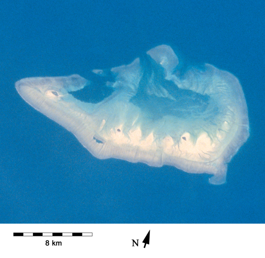
Featured image: NASA astronaut photograph STS060-75-25 of Ashmore Reef; public domain, via Wikimedia Commons. The image is a geographic illustration, not a chart or visitor access notice.

Choose your learning route
Fast answer: Who administers this territory? · Why is the reef protected? · What should ordinary readers understand about visiting?
Study route: Ten linked lessons · Worked example · Family learning · Bilingual vocabulary
Quick facts for readers
| Question | Reliable starting answer |
|---|---|
| Where? | Eastern Indian Ocean, northwest of mainland Australia, near Indonesia. |
| Political status? | Australian external territory; not an independent country. |
| Protected areas? | Ashmore Reef National Nature Reserve and Cartier Island Marine Reserve. |
| International significance? | Ashmore Reef is a Ramsar wetland of international importance. |
| Can everyone go ashore? | No. Island-specific restrictions and the particular traditional fishing arrangement apply. |
| Best study tools? | Official maps, Ramsar records, ecological research and photographs. |
Contents: ten things to learn
Pick any lesson. Each gives a grounded explanation, an activity and an answer check.
1. Read the two reefs as a territory, not one beach
2. Understand why a reef photograph is not a navigation chart
3. Follow the 1974 Australia–Indonesia memorandum carefully
4. Recognise the Ramsar wetland designation and its purpose
5. Discover why turtles need more than a nesting beach
6. Read large seabird figures without inventing a population trend
7. Investigate sea snakes and the limits of an inventory
8. Understand research permissions through a real example
9. Separate managing a reserve from owning a whole ocean
10. Make the responsible decision before imagining a visit
Worked example · Family plan · Vocabulary · Questions · Sources · Keep learning
1. Read the two reefs as a territory, not one beach
Ashmore and Cartier Islands form a remote Australian external territory in the eastern Indian Ocean, northwest of the Australian mainland. The Australian Government’s territory overview distinguishes Ashmore Reef from Cartier Island and explains how the two places are administered. A shared territorial name is not proof that every reef has the same landforms, habitat or access arrangements.
Open a regional map first. Locate northwestern Australia, Indonesia and the Timor Sea region; then zoom towards the reefs. A map of national boundaries answers a different question from a map showing reef flats, lagoons and islets. Even when a satellite photograph makes shallow water appear turquoise, colour is not an authorised depth chart. Map scale, imaging conditions and tides limit what it tells you.
Look at the NASA photograph of Ashmore Reef used as the featured image. Its visible patterns support questions about water and reef form, but they do not show the management boundary of Cartier Island. Keep the distinction between the two reefs in each caption. This is a practical way to avoid mixing separate conservation areas into one imaginary holiday beach.
Try this: Draw two labelled boxes for Ashmore Reef and Cartier Island. Under each, record a fact from the official territory page and a question the page does not answer.
Does a territorial label mean the islands have identical rules?
No. Specific reserve boundaries and conditions apply to specific places and activities.
← Previous · Contents · Next →
2. Understand why a reef photograph is not a navigation chart
A reef is a physical structure with ridges, channels, lagoon environments and surfaces that may be exposed at different tides. Ashmore includes several low islands and sand cays associated with its reef system, as the Australian Ramsar wetlands description explains. What looks like one shallow patch from above can contain distinct environments below.
Imagine drawing the reef from two viewpoints. The first is a plan view, which shows its horizontal outline. The second is a cross-section, with reef flat, a deeper passage and ocean water. The second introduces depth, which is hidden by a flat outline. Neither imaginary drawing should be used for real navigation. Real charts and conditions are not interchangeable with a learning diagram.
For school work, label observations and inferences separately. “The image contains contrasting light and dark water colours” is an observation. “This specific pale patch is safe for a boat” is an operational claim that the image cannot establish. Reliable interpretation starts by choosing evidence suitable for the question rather than making a pretty image answer everything.
Try this: Make a plan view and a conceptual cross-section. Write ‘not to scale’ beneath the second and explain what would require actual depth measurements.
Can a bright-blue satellite image establish safe water depth?
No. Water colour alone does not supply reliable bathymetry, tides, reef hazards or safe routes.
← Previous · Contents · Next →
3. Follow the 1974 Australia–Indonesia memorandum carefully
The Australian Government describes a 1974 Memorandum of Understanding between Australia and Indonesia relating to traditional Indonesian fishers. The Ashmore Reef Ramsar profile adds that recognised traditional activity includes designated access to West Island for freshwater and cultural sites, as well as subsistence fishing using traditional methods under the applicable arrangements.
This is neither a generic permission for tourists nor a claim that every vessel may enter every zone. A reader should ask who is covered, which place is identified, what activity is described and which newer rules apply. That is how an historical agreement becomes part of geography and law without being reduced to an oversimplified sentence.
There is a human dimension here that a wildlife-only account can miss. A chart may show a remote island as an isolated point; historical travel, working knowledge and continuing relationships show connections beyond the boundary line. Do not substitute a made-up fisher’s diary for testimony. When a source does not describe an individual’s experience, acknowledge that gap.
Try this: Write a two-column note: ‘what the memorandum allows or recognises’ and ‘what it does not establish for an ordinary visitor’.
Does traditional fishing access imply ordinary tourism access?
No. It is a specific arrangement for specified groups and activities, not general permission.
← Previous · Contents · Next →
4. Recognise the Ramsar wetland designation and its purpose
Ashmore Reef is recognised as a wetland of international importance. The Australian Government’s Ramsar profile explains that the site meets six of the nine Ramsar criteria and identifies important marine and bird habitats. A Ramsar listing is a recognition of ecological importance; it is not a visitor promotion or an assurance that all wildlife populations are increasing.
The criteria ask different questions. One may concern waterbirds in significant numbers, another a proportion of a species’ population, and others special habitat roles. A statement about “six of nine criteria” is a count of listing criteria, not a score of six out of nine for reef health. Confusing the two would make the figure sound like an exam mark instead of a conservation classification.
Read the official site description with its date in mind. A document prepared for a particular listing year can remain authoritative about the designation, while a present-day census requires more recent fieldwork. If a child asks whether the reef is healthy right now, first decide what ‘healthy’ should mean and which variables an appropriate survey would measure.
Try this: Choose one Ramsar criterion or habitat from the official profile. Explain why it is important without describing the site as a theme park.
Does six Ramsar criteria mean Ashmore received a six-out-of-nine health score?
No. The number counts qualifying ecological criteria, not a percentage grade.
← Previous · Contents · Next →
5. Discover why turtles need more than a nesting beach
The Ramsar profile identifies feeding habitat for green, hawksbill and loggerhead turtles and important nesting and inter-nesting areas for green and hawksbill turtles. An inter-nesting area is a nearshore place a turtle may use between nesting attempts. Therefore, protecting only the sand on which an egg is laid would leave out another part of the life cycle.
Make a simple diagram with linked stages: feeding, movement, nesting, returning to nearshore waters and later activities. A single turtle may use more than one location and not all species follow an identical schedule. Such diagrams help explain ecological connectivity, but they are models, not satellite tracks of actual individual turtles.
When studying photographic evidence, do not treat a visible turtle as proof that a nest succeeded. Evidence for successful breeding may require repeated, permitted monitoring of nests and hatchling emergence. Tourists should not enter sensitive areas to seek proof themselves; official records and credited images offer a more responsible route for learning.
Try this: Create a turtle habitat diagram with arrows and a box that says what evidence a scientist would need to verify each link.
Does one photograph of a turtle establish nesting success?
No. Presence, nesting, emergence and survival are distinct observations.
← Previous · Contents · Next →
6. Read large seabird figures without inventing a population trend
The Ramsar site profile reports historical counts of large numbers of breeding seabirds and migratory waterbirds and lists multiple species that use the reef. Different counts can concern birds present, breeding birds, nesting pairs, occupied nests or seasonal visitors. Each number needs its unit, date and method.
The fact that a site regularly supports many birds does not mean a photograph of a dense flock yields a complete population estimate. Some birds are flying, some are at sea and some are hidden. Researchers plan surveys and often correct for detectability. A convincing statement about an increase requires comparisons gathered with suitably similar effort and timing.
Try a made-up example. During one survey, 100 birds are counted in an hour; in another, 150 are counted in two hours. The second raw total is higher, but the rate per hour is lower. Even this rate does not solve every difference in visibility or habitat. The exercise teaches why a headline number needs context.
Try this: Write the units and observation effort beside two hypothetical bird counts, then explain why counts alone may mislead.
Can ‘150 birds counted’ always be compared directly to ‘100 birds counted’?
No. Time, area, season and survey method must be sufficiently comparable.
← Previous · Contents · Next →
7. Investigate sea snakes and the limits of an inventory
A marine biodiversity inventory may include sea snakes, corals, clams and other invertebrates. The official Ashmore Reef wetland account names these groups among subjects of monitoring and research. Scientists may use different methods for animals that swim, hide in crevices or appear more often at night.
A record that a species was observed at a site establishes presence during that observation. It does not automatically establish abundance throughout the reef. Conversely, not seeing an animal during a short survey does not prove local extinction. Detectability varies with conditions, equipment, season and experience.
Use an imaginary class exercise: a student finds three shells on one section of a beach and none in the next. Before claiming the first beach has “more life”, ask whether both sections were searched with the same area and effort, and whether shells are good indicators of the living organisms you want to know about. Scientists ask the same questions at greater scale.
Try this: Make a table with columns ‘observation’, ‘possible explanation’ and ‘further evidence needed’.
Does one zero-count survey prove a species is absent?
No. A zero may reflect true absence or imperfect detection.
← Previous · Contents · Next →
8. Understand research permissions through a real example
Scientific work in a protected area can require specific authorisations. The department’s 2012 seabird-permit application record describes a proposal to band, measure, sample or attach tracking devices to birds at Ashmore Reef and Cartier Island. The application record is evidence that permission was sought; the appearance of a proposal is not, by itself, proof that every action occurred or that permission was granted.
The 2016 application concerning naturally deceased birds likewise shows why even the collection of biological specimens is regulated. A researcher needs to identify the purpose, affected species, methods and likely impacts. That process helps distinguish scientific activity from collecting souvenirs or disturbing wildlife as a tourist.
For a school enquiry, compare the question asked with the proposed method. Tracking might help answer where animals travel; measuring could describe body size; a count could describe numbers at a site. No single technique answers every ecological question. Responsible research begins with choosing a method that is both informative and appropriately authorised.
Try this: Write an imaginary research question and select the least intrusive evidence that could answer it. Label it a proposal, not an approval.
Does publication of a permit application prove that the activity happened?
No. An application, an authorisation and completed fieldwork are different records.
← Previous · Contents · Next →
9. Separate managing a reserve from owning a whole ocean
The territory overview identifies the legal and administrative framework for the islands. Ashmore Reef National Nature Reserve was established in 1983, and Cartier Island Marine Reserve followed in 2000. Reserve names, territorial status, maritime zones and historical access arrangements have different meanings.
This is useful practice in political and environmental geography. A territory is an administrative unit; a reserve defines a protected place with designated rules; a maritime boundary addresses jurisdiction at sea. A conservation designation should not be interpreted as Australia owning every surrounding stretch of ocean without qualification.
Draw three overlapping circles labelled territory, habitat and rules. Use a real government map to replace the circles only when its legend is clear. If an official page discusses a reserve, do not silently turn the statement into a claim about all nearby reefs. Accurate naming keeps complicated governance understandable.
Try this: Write one sentence about territorial administration and a separate one about reserve protection, each with an official link.
Are territorial administration and reserve management identical concepts?
No. They describe related but distinct legal functions and boundaries.
← Previous · Contents · Next →
10. Make the responsible decision before imagining a visit
Ashmore and Cartier are remote protected areas, not ordinary island resorts. The Australian Government specifies permit-only access to East and Middle Islands, while the Ramsar page describes designated traditional access at West Island. None of those statements should be turned into a universal recommendation to land.
A good itinerary-checking question is specific: who intends to do which activity, at which exact location, under whose authorisation? For the family learning activities in this guide, no landing is necessary. You can study habitat maps, photographs, official monitoring and cultural histories from home without disturbing a nesting beach or a protected reef.
Finish with the practical lesson shared across this series: an inaccessible or restricted location can still be a valuable place to understand. The point of learning is not to collect proof of personal arrival but to explain why a place matters, whose relationships it contains, and what the evidence allows us to say.
Try this: Make a one-page remote-learning poster showing a map, two ecological processes, a dated fact and the distinction between traditional access and tourism.
Is a reef photograph or an earlier voyage report a current landing permit?
No. Permission depends on the present activity, place and applicable authorisation.
← Previous · Contents · Next →
Worked example: avoid a false bird-count trend
Imaginary classroom data, not Ashmore census figures: a team counts 80 birds in 40 minutes at one viewing point and 120 birds in 80 minutes at another. The raw second count is larger, but the efforts are not equal. Calculate both rates before comparing them.
At the first point, 80 ÷ 40 = 2 birds recorded per minute. At the second point, 120 ÷ 80 = 1.5 birds recorded per minute. Under this simple calculation, the second site has the larger total but smaller rate. The difference in rates is 0.5 birds per minute.
Does that prove the first site has more birds? No. Differences in habitat, observation distance, season, individuals moving through the frame or observers counting the same bird twice may affect the result. The rate is a more careful start, not a final population estimate.
Now improve the method: compare the same defined area at the same season, plan repeat counts, document observation rules, and distinguish birds seen from breeding nests. The Ramsar record shows why different ecological measures matter. Never turn these invented numbers into a current fact about Ashmore.
Family learning plan: one hour without travelling
Spend fifteen minutes with two maps. One family member locates the territory within the region; another identifies the two named reef areas. Ask what each map leaves out. Make a small caption that distinguishes Ashmore Reef from Cartier Island.
Use the next fifteen minutes to trace one ecological relationship. Choose a nesting turtle, a migratory waterbird or a seabird. Draw its land and sea habitat connections, then name what evidence the government profile supplies.
Spend fifteen minutes on people and the law. Read the government explanation of the 1974 fishing arrangement. Have one learner explain why specified traditional access is different from unrestricted tourism, without inventing anyone’s testimony.
Finish by checking one observation. Use the imaginary bird-count example or compare two wildlife photographs. Each learner states one supported conclusion and one limitation. A useful exhibit includes a source, date and an accurate restriction note.
English–Simplified Chinese vocabulary
| English | 简体中文 | Meaning here |
|---|---|---|
| Territory | 领地 | A place administered under a particular political and legal status. |
| Reef | 礁 | Rocky or biogenic structure close to or below the sea surface. |
| Lagoon | 潟湖 | Shallow water separated in part by a reef or barrier. |
| Sand cay | 沙洲岛 | Low land formed from deposited reef-derived sediments. |
| Ramsar wetland | 拉姆萨尔湿地 | Wetland recognised under the Ramsar Convention. |
| Seabird | 海鸟 | Bird whose feeding and life cycle are closely connected to the sea. |
| Migratory | 迁徙的 | Moving between regions, often in regular seasonal patterns. |
| Inter-nesting habitat | 产卵间歇栖息地 | Habitat used by turtles between nesting attempts. |
| Survey effort | 调查工作量 | How long or how extensively observers searched. |
| Detectability | 可探测性 | The chance that an organism present will be recorded. |
| Permit | 许可证 | Formal authorisation for a specified activity. |
| Traditional use | 传统利用 | Recognised practices connected with history and community. |
| Biosecurity | 生物安全防护 | Measures to limit harmful biological introductions. |
Frequently asked questions
Can visitors book a normal beach holiday here?
No. These are remote protected areas; the official Australian guidance must be checked for the exact activity, and important islands have permit-only access.
Do Ashmore Reef and Cartier Island form one continuous beach?
No. They are separately named features within the same Australian external territory.
Does the 1974 arrangement cover all tourists?
No. It describes specified traditional Indonesian fishing and West Island activities, not unrestricted visitor access.
Is the Ramsar listing a travel recommendation?
No. It recognises internationally important wetland values.
What is inter-nesting habitat?
Nearshore habitat turtles use between nesting attempts. It illustrates why protection extends beyond the nest site.
Can an old bird count describe current breeding success?
No. Keep its observation date and unit; current success requires current, comparable evidence.
Do all sea snakes become visible in a single survey?
No. Detection varies with method, timing, conditions and the species.
Can a public permit application be treated as final approval?
No. Applications, decisions and fieldwork need separate records.
Why is the featured image credited to NASA?
Its Wikimedia Commons source identifies it as NASA astronaut image STS060-75-25, in the public domain in the United States.
What makes a good school project?
A correctly labelled map, one sourced historical or management point, one ecological explanation and a statement of what remains unknown.
Sources and further reading
These records support the factual statements in the ten lessons. Separate the dates of a historical agreement, a scientific survey and the date a web record was updated.
Australian Government: Ashmore and Cartier Islands territory and access
DCCEEW: Ashmore Reef Ramsar wetlands profile
DCCEEW: 2012 seabird monitoring permit application
DCCEEW: 2016 naturally deceased birds permit application
NASA Ashmore Reef photograph and public-domain licence on Wikimedia Commons
Keep learning around the Indian Ocean
Companion article: Top 10 Things to Do When Visiting and Touring Ashmore and Cartier Islands
Coral Sea Islands: science and visitor restrictions