
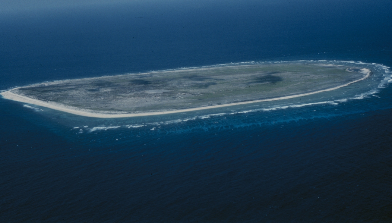
Baker Island is a place to explore through research, maps and archives, with no ordinary tourist access. The U.S. Fish and Wildlife Service describes entry as permit-only for its personnel, scientists and researchers. This guide offers ten things you can learn without visiting: ocean geography, reef formation, currents, guano, Hawaiian experiences, place names, historical photographs, scientific surveys, seabird recovery and coral stress.
Start with the subject that catches your attention. A tiny island on a map can open a very large question: how does the ocean help build land, carry food and connect places? A photograph can lead you towards a person’s experience or a piece of evidence that changes an explanation. You need only a screen, paper and a willingness to ask what a source actually shows. Every activity below can be completed at home, and the numerical exercises are clearly labelled as invented examples.
Featured photograph: Baker Island National Wildlife Refuge. Photo: USFWS, Pacific Islands; public domain. Photograph date not specified by the source.
Choose your learning route
Get your bearings: Read the quick facts and start with the map lesson.
Follow a subject: Choose a lesson from the contents; each includes an activity and an answer check.
Practise a skill: Work through the example, then explain the result in your own words.
Learn together: Use the family plan and English–Chinese vocabulary.
Quick facts for your study
| Starting point | Useful question |
|---|---|
| Central Pacific geography | What disappears when a map shows land alone? |
| Coral and ocean science | Which process could explain the pattern? |
| Hawaiian and institutional archives | Whose experience does this record preserve? |
| Wildlife surveys | What was counted, where and when? |
| Remote study | How can learning support protection without physical entry? |
Contents: ten lessons and practical activities
Open a group to choose a lesson. The full explanations remain available below.
Lessons 1–3: begin with the place
1. Read Baker as an ocean place, not only a patch of land
Lessons 4–7: follow the evidence
4. Use guano to connect seabirds, nutrients and economic history
5. Meet the Hui Panalāʻau through their own accounts
Lessons 8–10: investigate and explain
8. Discover how a reef survey turns observations into a defensible claim
9. Understand seabird recovery as a connection between islands
10. Distinguish a coral heat warning from a measured biological outcome
Worked example · Family plan · Vocabulary · Frequently asked questions · Sources · Keep learning
1. Read Baker as an ocean place, not only a patch of land
Find Baker in the central Pacific, just north of the equator. The refuge description places it about 1,830 nautical miles southwest of Honolulu and explains that its surroundings include extensive submerged habitat. A land-only map therefore leaves much of the setting outside your attention.
Begin with three scales. On a globe, locate the Pacific and the equator. On a regional map, locate Baker and neighbouring Howland. On an island image, examine the coastline and shallow-water margin. Each scale answers a different question. The globe helps with global position; the regional view shows relationships; the close view reveals features that would disappear at the first scale.
Here is an invented scale exercise. Suppose a map key says that one centimetre represents 200 kilometres. Two points separated by three centimetres are approximately 600 kilometres apart on that map. A second map might show the same three-centimetre gap representing only six kilometres. Measuring the gap without reading the key would produce a confident but useless answer.
Keep distance separate from practical reachability. A straight line measures separation, while a real journey also requires permission, transport, suitable conditions and support. In this guide, the useful destination is a better explanation. When you describe Baker, say which view you used and what it cannot reveal. A regional map cannot show a particular nest, and a close photograph cannot explain the whole ocean.
Try this: Draw three boxes labelled globe, regional map and close image. Put one question under each that only that scale can answer well.
Check your understanding: Does a small symbol on a world map mean that Baker has little ecological significance?
No. The symbol reflects the map’s scale. Ecological significance requires evidence about habitats, organisms and connections.
← Contents · Contents · Lesson 2 →
2. Separate the living reef from the land it helps create
A coral island invites an interesting materials question: which parts are alive, and which parts are the remains or products of living things? NOAA’s reef-formation tutorial explains that hard corals build reef structures. It also describes how reef growth around a sinking volcanic island can eventually produce an atoll. This is a general model, not a complete geological history inferred from one Baker photograph.
Imagine two drawings. In the first, label the submerged volcanic foundation, reef framework and material above the water. In the second, enlarge a small living coral colony. The first drawing concerns a landscape built over time; the second concerns organisms within that landscape. Keeping them separate prevents an easy mistake: treating the entire island as one enormous living coral.
A classroom model can make the distinction clearer. Place a small mound of modelling clay inside a shallow tray and arrange a separate ring of counters around it. Let the clay represent the foundation and the counters represent reef growth. Describe what each part stands for before changing anything. The counters do not grow or reproduce, and the tray cannot reproduce waves, sediments or geological time. Those limits belong in the explanation.
Now compare this model with a verified island image. Which features match, which need a more complicated model, and which are impossible to identify from above? Resist forcing every low island into a perfect doughnut. The shape of a general textbook diagram is a starting hypothesis. The actual place supplies the evidence that can refine it.
Try this: Write two captions: one for a living coral colony and one for an island landscape. Make the difference in scale and timescale unmistakable.
Check your understanding: Can a photograph of pale ground prove that living coral covers the island?
No. Appearance alone cannot establish the material’s identity, whether it is alive or how it reached that position.
← Lesson 1 · Contents · Lesson 3 →
3. Follow a current that a surface photograph cannot show
Baker’s underwater setting matters as much as its outline. The Fish and Wildlife Service explains that the equatorial undercurrent brings nutrient-rich water upwards around the island, supporting marine productivity. The interesting lesson is that a small landmass can participate in a much larger moving system.
Think of a familiar comparison: traffic on two levels of a road interchange. Looking only at the upper road would miss movement below it. Ocean water also has depth, direction and changing properties. The comparison helps us remember the missing dimension, although water flows differently from vehicles and the analogy cannot predict an actual current.
Build an explanation one link at a time. Water moves; the underwater shape influences that movement; water with different properties reaches shallower areas; organisms respond to the available conditions. Avoid jumping straight from ‘there is a current’ to ‘every species must be abundant’. Different organisms have different requirements, and a plausible connection still needs observations.
For an invented investigation, imagine receiving temperature records from the eastern and western sides of an island at the same depth. One side is repeatedly cooler. What else would you request before explaining the difference? Dates, measurement depth, instrument information and current observations would help. A single cool reading could have several explanations. Repeated measurements collected in comparable ways let you test whether the pattern persists. This habit transfers neatly to questions about shaded school grounds, urban heat and water in a reservoir.
Try this: Sketch a side view of an island and add labelled arrows for a possible water movement. Mark the drawing ‘conceptual model; not a navigation chart’.
Check your understanding: Does nutrient-rich water automatically mean pollution?
No. Nutrients can arrive through natural ocean processes. Their source, concentration and ecological context must be established.
← Lesson 2 · Contents · Lesson 4 →
4. Use guano to connect seabirds, nutrients and economic history
Guano is accumulated animal droppings; on seabird islands it makes a connection between ocean feeding and land especially visible. A Fish and Wildlife Service historical account places Baker within the nineteenth-century guano-mining era before the later equatorial-islands settlement project. A substance produced by wildlife became something people travelled far to extract.
Follow two different stories on the same sheet. The ecological story asks where nutrients originate, how birds move them and what happens after deposition. The economic story asks who organised extraction, who performed the labour, how material was transported and who received the benefit. Neither story is complete if the other disappears.
There is useful comparative research, provided we keep its location clear. A study of the Aleutian Islands examined how introduced foxes reduced seabirds and disrupted nutrient movement from sea to land. It is evidence from Alaska, not a measurement from Baker. It helps generate a question about connected island systems; it cannot supply Baker’s answer.
Try an invented extraction ledger. A project earns 100 units from selling a material and records 70 units of operating costs. Its accounting surplus is 30 units. Now add a second page for effects the ledger did not measure, such as habitat disturbance or future restoration work. Do not invent a monetary value for those effects. Instead, identify the missing evidence. The lesson is how the boundary of an account can shape what appears profitable.
Try this: Make two columns headed ‘transaction recorded’ and ‘effect needing investigation’. Explain why an empty entry in the second column does not mean zero effect.
Check your understanding: Can an ecological finding from Alaska be presented as a measured result for Baker?
No. It can support a comparison or hypothesis, while Baker-specific conclusions need Baker-specific evidence.
← Lesson 3 · Contents · Lesson 5 →
5. Meet the Hui Panalāʻau through their own accounts
Baker’s history includes people whose work can disappear inside a brief phrase such as ‘territorial claim’. The University of Hawaiʻi Center for Oral History preserves interviews with eight men involved in the equatorial-islands project. Its collection was published in 2006 and concerns experiences during the late 1930s and early 1940s. Select accounts that actually mention Baker; participation on another island is not automatically Baker experience.
The FWS account of the project describes the recruitment of young men from Hawaiʻi, including Kamehameha students and graduates, for a U.S. undertaking connected with possession and aviation. Read the government’s purpose alongside participants’ experiences. Institutions and individuals can describe the same project from very different positions.
An interview invites several questions. Who is speaking? Which island and period are being discussed? Was the account recorded during the event or recalled later? What does the speaker emphasise: work, friendships, uncertainty, communication, family or something else? Begin with the person’s actual words before supplying your own interpretation.
You can acknowledge both value and limits without dismissing a source. A later recollection may explain personal meaning that an official form never recorded. A dated logbook may help check sequence. A photograph may preserve a setting while leaving the photographer’s instructions unknown. Bring records together so that one illuminates another. Avoid writing a fictional diary in a real participant’s voice; explain what you learned and identify the questions still open.
Try this: Choose one Baker-related passage. Record the speaker or writer, event date, recording date if available, and one point that a second source could help check.
Check your understanding: Does an interview's publication date tell us when the historical experience occurred?
No. Event, interview and publication dates may differ. Record each separately when the source provides it.
← Lesson 4 · Contents · Lesson 6 →
6. Ask what place names preserve about belonging and memory
A place name is useful for finding a location, and it can also preserve a relationship. The March 2024 cultural-recognition assessment lists Puakaʻilima among historical names associated with Baker and connects it with Hawaiian guano labourers and the ʻilima flower. It also records a participant associating this name with Howland. The authors caution that names and name elements were not fully vetted with language and cultural experts. Keep those qualifications visible when explaining the name.
Compare a name associated with a ship’s captain with a name that recalls a flower or home. Each may direct attention towards a different human relationship. That observation does not tell us everything about the people who used either name. It does show why a map legend is more than a neutral list of sounds.
Make a careful name record with four fields: spelling as printed, language or community identified by the source, source and date, and explanation given. Preserve marks such as the ʻokina when copying Hawaiian words. If the document gives uncertain or differing information, keep that qualification visible. Tidying a complicated history into one confident sentence can remove the very lesson worth learning.
This activity transfers to Singapore street names, family names and the names of buildings. Ask who named something, whose account survives and whether the name’s use has changed. Do not invent an Indigenous name to make a caption sound more meaningful. The respectful task is to find, attribute and understand what people have actually recorded, while recognising whose knowledge a short institutional entry might not contain.
Try this: Compare two documented names or naming explanations. Write one question each raises about history, then identify who might hold the knowledge needed to answer it.
Check your understanding: Does appearing in a 2024 assessment establish a name's current legal status?
No. Historical documentation, a proposal and a formally adopted legal name are different kinds of evidence.
← Lesson 5 · Contents · Lesson 7 →
7. Read an old photograph as a dated piece of evidence
The Smithsonian Institution Archives’ digitised Baker Island collection brings together photographs dated 1937–1938, 1948 and undated material. Its catalogue identifies subjects including terrain, buildings and wildlife. This is an excellent place to practise looking carefully without turning an old image into a claim about present conditions.
First separate the photograph from its catalogue entry. The image contains visible shapes, relationships and details. The catalogue may supply a date, location, creator or institutional history that is not visible in the picture itself. Both are useful, but they answer different questions. A date typed below an image belongs to its documentation, not to the landscape.
Use three passes. In the first, describe only what you can see: a low building, a pole, a bird, a shoreline. In the second, add information supplied by the caption. In the third, form a question about function or change. A structure might suggest communication infrastructure, but its exact equipment, working condition and operating dates require further records.
An invented example makes the distinction easy. Suppose a photograph shows a roof and two walls. ‘A building is visible’ is an observation. ‘The building provided shelter’ is a plausible interpretation. ‘This was a comfortable home for everyone’ goes much further than the evidence allows. Good historical writing explains the step from observation to interpretation rather than hiding it. It also allows the people represented to have experiences that the camera did not capture.
Try this: Write a 60-word caption containing a visible detail, one attributed catalogue fact and one question. Keep the image’s historical date explicit.
Check your understanding: Can a historical photograph establish that a structure is intact or usable today?
No. It records a past view. Current condition and access require separate, current evidence.
← Lesson 6 · Contents · Lesson 8 →
8. Discover how a reef survey turns observations into a defensible claim
A beautiful underwater image is a beginning, but a monitoring programme needs comparable observations. NOAA’s Pacific coral-reef monitoring description explains that scientists survey fish without taking them, recording numbers and sizes. Consistent methods help researchers compare places and periods. Baker is included among the programme’s Pacific Remote Island Areas.
The Baker Island chapter of NOAA’s 2019 monitoring report is a historical research resource, with sections addressing reef communities and their environmental setting. Its publication date matters. A website page updated later does not turn the underlying observations into a new survey of today’s reef.
Try a paper survey using a grid of 100 squares. Colour 28 squares to represent coral cover in an invented image. Your classroom estimate is 28 percent of that image’s sampled area. It is not 28 percent of every reef around Baker, and it says nothing by itself about the number of coral species. The denominator determines what your percentage means.
Now imagine that a second image contains 35 coloured squares. Before calling this recovery, ask whether the pictures represent comparable areas, depths, dates and methods. Perhaps the photographer moved to a different patch. Perhaps the same patch was sampled but the identification rules changed. Comparing numbers is the easy part; establishing a fair comparison is the scientific work. A careful sentence should name the measure, place, period and uncertainty.
Try this: Rewrite ‘the reef is healthier’ as a narrower claim that could be tested with a defined measure and repeated observations.
Check your understanding: Are coral cover, fish abundance and species richness interchangeable measurements?
No. They describe area occupied, numbers of fish and numbers of species respectively. One measure cannot stand in for all the others.
← Lesson 7 · Contents · Lesson 9 →
9. Understand seabird recovery as a connection between islands
Baker provides a useful correction to the idea that conservation happens within isolated boxes. Rauzon and colleagues’ published study examines seabirds after cat control or disappearance on Baker, Howland and Jarvis. It describes movement between nearby Baker and Howland as conditions changed. This is historical research, not a present-day census or a single identical eradication story for all three islands.
Consider an invented pair of counts. Island A has 100 birds and Island B has 400. Later, A has 200 and B has 300. A’s count doubled, but the combined count remained 500. Movement could explain the pattern without any increase in the combined population. These numbers are a classroom example, not records for Baker or Howland.
The example also has limits. Real counts may omit birds at sea, cover different seasons or use different methods. Young birds may enter the population while other birds die or move elsewhere. To distinguish these processes, researchers need more than two totals. Marking studies, breeding observations and comparable repeated surveys can help answer different parts of the question.
Now think about restoration goals. Removing a pressure is one action; demonstrating recovery requires evidence about what follows. More adults resting on an island, more occupied nests and more young surviving are related but distinct outcomes. This is why a patient account of recovery is more useful than a simple before-and-after celebration. It helps us ask whether the conditions supporting wildlife remain dependable.
Try this: Invent a second two-island example where the combined count increases. State two possible explanations and what further observations would help distinguish them.
Check your understanding: Does a larger count on Baker necessarily show that more birds were born there?
No. Movement and survey differences are among the alternatives. Births need evidence about breeding and recruitment.
← Lesson 8 · Contents · Lesson 10 →
10. Distinguish a coral heat warning from a measured biological outcome
A remote reef can still experience environmental change. NOAA explains that coral bleaching involves the loss of the microscopic algae living with corals under stressful conditions. Bleaching does not automatically mean death; continued stress can make the outcome worse. This biological distinction matters when reading dramatic headlines.
For changing conditions, NOAA Coral Reef Watch supplies satellite-based products and outlooks, including sea-surface temperature and accumulated heat-stress measures. These tools help identify environmental pressure. They do not replace direct observations of a particular colony or prove that every coral within a mapped area has the same response.
Use an everyday comparison. A forecast of heavy rain tells a school to prepare, but it does not establish that every classroom flooded. A photograph of one wet classroom supplies different evidence. Similarly, a heat-stress indicator, a bleaching survey and a later survival assessment describe different stages of an environmental event.
When you look at a data display, record the product name, date, geographical area and unit. Read its explanation before interpreting the colours. If you cannot determine what the map represents, write that uncertainty rather than supplying an answer from the colour alone. For Baker, a useful learning report could explain which information you would combine to evaluate a reef: environmental records, consistent observations and follow-up measurements. The result is a better question, even when current site-specific evidence is unavailable.
Try this: Write separate sentences for an environmental warning, an observed response and a later outcome. Make clear what evidence each sentence would require.
Check your understanding: Does the absence of ordinary tourism guarantee that a reef cannot be stressed?
No. Access restrictions and environmental conditions address different pressures. An ecological assessment must consider the relevant evidence for each.
← Lesson 9 · Contents · Worked example →
Worked application: what can two reef images actually tell us?
Invented classroom data: two labelled photographs show the same practice grid at different times. The first has 24 coral squares out of 100 and the second has 30. These are teaching numbers, not NOAA observations or measurements from Baker. Begin by stating the narrow result: coral occupies six additional squares in the second image.
The cover estimate rises from 24 percent to 30 percent, an increase of six percentage points. Relative to the starting estimate, the increase is 6 divided by 24, or 25 percent. Both calculations are correct, but they answer different questions. Writing simply ‘a six percent increase’ would blur the distinction.
Next, decide whether the comparison is fair. The exercise says the grid is the same, but real photographs would require matching location, area and method. You would also want the dates and an explanation of how a square was classified. If the second image is clearer, a change in identification could affect the result.
Now test a proposed conclusion: ‘The entire island’s ecosystem has recovered.’ The evidence cannot support that scale of claim. It measures one feature in one sampled area. It does not establish fish abundance, coral diversity, seabird breeding or the reason for the change.
A stronger conclusion would be: ‘In this invented, matched-image exercise, estimated coral cover increased from 24 to 30 percent. Wider ecological conclusions would require additional measures and repeated sampling.’ Finish by proposing one useful next step. Comparing several consistently selected sites would tell you whether the pattern is widespread, while a later repeat would help show whether it persists. You have moved from an attractive number to a statement another person can inspect.
← Lesson 10 · Contents · Family plan →
A manageable family learning plan
Begin with a 15-minute map session. One person finds Baker, another reads the map key, and a third asks what the map leaves out. Younger children can draw the land and surrounding water; older learners can explain how scale changes the questions they can answer. Keep one accurate sentence from the discussion.
Use a second session for a historical source. Choose a Baker-related record from the Hui Panalāʻau collection or a photograph in the Smithsonian archive. Identify its date and creator where supplied. Let each person distinguish one observation from one interpretation. You do not need to finish an entire archive to make a useful discovery.
For the third session, complete the invented reef-grid calculation. Ask someone to explain why six percentage points and 25 percent relative growth can describe the same change. Then remove one piece of information, such as the matching location, and discuss how the conclusion becomes weaker.
Finish with a short piece of writing or a two-minute spoken explanation. Choose a single question: how reefs form, why birds connect islands, or what an old photograph can tell us. Include one linked source, one clear explanation and one limit. The aim is a thought you can defend, not a page full of copied facts. Return to the Howland Island learning guide when you are ready to test which ideas transfer and which need new evidence.
← Worked example · Contents · Vocabulary →
English–Simplified Chinese vocabulary
Use these words in an explanation of the island. The meanings below give the intended geography, history or science sense.
| English | 简体中文 | Meaning in this guide |
|---|---|---|
| equator | 赤道 | The imaginary line at zero degrees latitude dividing the Northern and Southern Hemispheres. |
| submerged | 水下的 | Below the surface of water; land above water does not describe every habitat. |
| reef | 礁 | A submerged or shallow-water structure; a coral reef includes a framework built by organisms. |
| undercurrent | 潜流 | A current below the surface, whose movement may differ from surface water. |
| nutrient | 营养物质 | A substance organisms use for growth and other life processes. |
| guano | 鸟粪肥 | Accumulated droppings, often associated with seabirds and historically collected as fertiliser. |
| oral history | 口述历史 | Recorded accounts in which people describe and reflect on their experiences. |
| provenance | 来源记录 | Information tracing where a record or object came from and who created or held it. |
| sample | 样本 | A selected part studied to answer a question about a larger set. |
| species richness | 物种丰富度 | The number of different species recorded within a defined sample or area. |
| recolonisation | 重新定殖 | The return and establishment of organisms in an area where they had disappeared. |
| bleaching | 珊瑚白化 | Paling associated with coral stress and loss of symbiotic algae; distinct from confirmed death. |
← Family plan · Contents · Questions and answers →
Frequently asked questions
Can families visit Baker Island for these activities?
These activities are designed for home or classroom study. FWS describes access as restricted to permitted personnel and researchers; this is not a visitor-booking route. Use the refuge’s own information for its access position.
Is Baker Island a country with towns and everyday visitor services?
Baker is a U.S. island territory managed as a wildlife refuge, rather than a sovereign country or a destination with a resident town. Its inclusion in a wider country-and-destination learning series does not change that distinction.
Are Howland and Baker the same island?
No. Keep their maps, historical records and observations separate. A comparative study may connect them, but an event documented on Howland cannot be moved to Baker merely because both appear in the same chapter or expedition account.
Does an atoll diagram reproduce Baker's exact shape?
No. A general reef-formation diagram illustrates processes. Use a verified image or map for the particular island, and avoid adding a lagoon or other feature simply because it appears in a familiar textbook diagram.
Why does a Baker guide include Hawaiian history?
Baker appears in records of the Hui Panalāʻau and earlier labour histories. The oral-history collection helps readers encounter people’s experiences alongside institutional accounts. Check which participant and island each passage concerns.
Can I use old wildlife counts as today's population?
No. State the survey date, location, method and what the count represents. A historical count remains useful evidence, but converting it into a present-day total removes the information needed to interpret it honestly.
Are the reef percentages and bird totals in this guide real Baker data?
No. They are explicitly invented teaching examples. They demonstrate calculation and interpretation. Refer to the linked research for actual observations, and preserve the dates, units and qualifications attached to those records.
What should younger children focus on?
Choose one visible relationship: land and water, a bird and its habitat, or a photograph and its caption. Ask the child to describe a detail and give a reason. Leave advanced calculations for when they become useful.
How do I avoid copying a source instead of learning from it?
Read a short section, close it and explain the idea in your own words. Reopen it to check accuracy and add the link. Then ask a new question or apply the idea to a clearly labelled example.
What is a good final Baker Island learning outcome?
Produce one accurate explanation connecting a place, a source and a process. For example, explain why a changed bird count could reflect movement between islands. Include what the evidence supports and what further information would improve the conclusion.
← Vocabulary · Contents · Sources →
Sources and further reading
The links throughout the guide identify the evidence behind factual claims. Dates attached to historical observations matter. Check the responsible agency’s current notices before considering any authorised activity.
U.S. Fish and Wildlife Service: Baker Island refuge and access information
U.S. Fish and Wildlife Service: A Story of the Hui Panalaʻau
USGS: seabirds, introduced predators and nutrient transfers in the Aleutian Islands
University of Hawaiʻi Center for Oral History: Hui Panalāʻau collection
Hui Panalāʻau Digital Collection: archival repositories and collection descriptions
FWS and Udall Foundation: March 2024 cultural-recognition assessment
Smithsonian Institution Archives: Baker Island photographs, 1937–1938, 1948 and undated
NOAA Fisheries: coral-reef monitoring in the Pacific
NOAA: 2019 coral-reef monitoring report, Chapter 8 Baker Island
Rauzon and colleagues: seabird recovery at Howland, Baker and Jarvis, author-posted research
NOAA: coral bleaching explained
NOAA Coral Reef Watch: environmental monitoring products
Photograph source and credit: Baker Island National Wildlife Refuge. Photo: USFWS, Pacific Islands; public domain. Photograph date not specified by the source.
← Questions and answers · Contents · Keep learning →
Keep learning about islands and the wider world
Howland Island: ten things to learn
Baker Island: ten things to do through responsible remote discovery