
Rangitāhua/Kermadec Islands are a remote subtropical New Zealand island group shaped by active volcanism, Polynesian history, seabird colonies and a vast no-take marine reserve. They are not part of New Zealand’s subantarctic World Heritage cluster. The Department of Conservation currently considers research permit applications only, not ordinary recreational landings.
Ten evidence-based lessons connect the region’s geology, Māori history, ocean life, marine protection and today’s visitor rules. Each has an activity and an answer check, followed by a worked unit conversion, family plan, bilingual vocabulary, ten FAQs and verified sources.
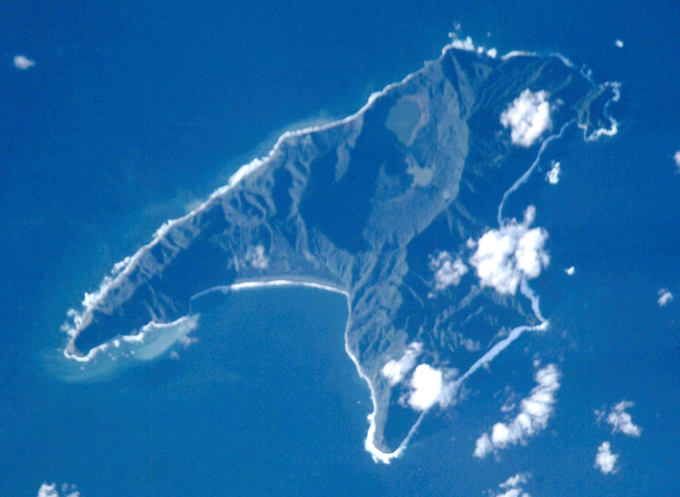
Featured image: Raoul Island as seen from the International Space Station, NASA Expedition 2, 13 July 2001, U.S. public domain via Wikimedia Commons. It is an older image of Raoul, not a real-time volcanic or navigation map.

Choose a route: Quick facts · Ten lessons · Worked example · Family learning · Bilingual vocabulary
Quick facts
| Question | Evidence-based starting answer |
|---|---|
| Where? | Subtropical Pacific, roughly 1,000 km northeast of New Zealand. |
| Largest island? | Raoul Island. |
| Geology? | Kermadec Trench subduction and active volcanic arc. |
| Cultural history? | Polynesian settlement evidence and enduring Ngāti Kuri / Māori connections. |
| Marine reserve? | Established 1990, around 748,000 hectares; no-take. |
| Current entry? | Specific research authorisations; recreational applications not being considered. |
Contents: ten things to learn
1. Place Rangitāhua about 1,000 kilometres northeast of New Zealand
2. Understand how a subducting tectonic plate creates volcanoes
3. Meet Raoul Island’s crater landscape and real volcanic hazard
4. Respect the deep Polynesian and Ngāti Kuri connections
5. Explain the different European and New Zealand administrative dates
6. Discover subtropical marine life and deep-ocean vents
7. Understand seabird colonies and pest-free island management
8. Read the 1990 Kermadec Islands Marine Reserve correctly
9. Understand how clean-hull rules prevent ecological harm
10. Check the current research-only policy before imagining a journey
Worked maths · Family plan · Vocabulary · FAQs · Sources · Related guides
1. Place Rangitāhua about 1,000 kilometres northeast of New Zealand
Rangitāhua/Kermadec Islands lie about 1,000 kilometres northeast of mainland New Zealand in the subtropical southwest Pacific Ocean. The New Zealand Department of Conservation (DOC) identifies Raoul Island as the largest and the northern islands as a group of extremely remote, protected sites. Their name should not be confused with the five New Zealand subantarctic UNESCO groups far to the south.
A suitable map shows New Zealand, Tonga and the chain of Kermadec islands. Then zoom to Raoul, Macauley, Curtis, Cheeseman and L’Esperance, without pretending these locations form a continuous strip of walkable land. The wider Kermadec volcanic system extends along an undersea arc, but individual island coastlines are only a small part of it.
The featured image is a NASA Expedition 2 view of Raoul Island from 13 July 2001. It illustrates one island and its landscape at that date, not current landings or the whole archipelago. When a caption identifies a feature, ask whether it is a visible observation or a geological interpretation requiring additional sources.
Try this: Make a two-scale map of the archipelago, then mark which island is shown in the NASA photograph.
Does an image of Raoul Island depict every island in the Kermadecs?
No. Raoul is the largest, but the archipelago contains other islands and islets.
← Previous · Contents · Next →
2. Understand how a subducting tectonic plate creates volcanoes
The Kermadec island arc is associated with tectonic convergence along the Kermadec Trench. The DOC geological overview describes the Pacific plate descending beneath the Australasian plate, while volcanism develops in the overriding region. This is an excellent physical-geography case study in subduction.
The system is much larger than the dry islands: DOC describes a volcano chain continuing between New Zealand and Tonga, including submerged volcanoes and vents. A classroom diagram can show one plate bending down, heat and pressure conditions at depth, and molten material feeding volcanic activity. Such a conceptual section cannot supply a modern eruption forecast or a precise earthquake hazard.
It is important not to confuse a tectonic boundary, the national marine reserve boundary and an administrative line on a map. The Earth processes extend well beyond the small territorial-sea areas covered by visitor-access rules. Different maps help answer different questions.
Try this: Draw two converging plates, a trench and a volcanic arc. Label it a model, not a hazard map.
Do tectonic plate boundaries coincide neatly with visitor permit boundaries?
No. One is a geological system and the other a legal or management boundary.
← Previous · Contents · Next →
3. Meet Raoul Island’s crater landscape and real volcanic hazard
Raoul Island includes crater lakes and caldera landforms. The DOC volcano-risk guidance identifies Raoul as a volcanically active island managed by the department, with a last eruption in 2006. It says Raoul is not accessible to the general public. A green island on an old satellite picture must not be described as a safely dormant volcano.
A volcanic crater lake is a body of water occupying a volcanic depression; it can reflect a complicated history of eruptions, collapse and drainage. For schoolwork, compare a contour map with a cross-section showing relief and water. Avoid extrapolating depth or gas levels from colour alone.
Scientists can use seismic, geochemical and other observations to investigate unrest. They cannot guarantee a particular future eruption date simply by looking at one photo. For a site with remote rescue options, physical risk supports the importance of the current research-only access policy.
Try this: Describe the difference between a crater lake visible in imagery and a measured volcanic hazard assessment.
Does a green-looking volcanic island mean eruptions are impossible?
No. DOC records a 2006 eruption on Raoul.
← Previous · Contents · Next →
4. Respect the deep Polynesian and Ngāti Kuri connections
The DOC history section records archaeological evidence of early Polynesian settlement on Raoul between approximately 600 and 1,000 years ago. Later use appears to have been intermittent. The remains include coastal settlement features and tools made from local basalt and obsidian.
Rangitāhua also holds a place in Māori oral histories and the voyages of Polynesian ancestors to Aotearoa. DOC specifically points to the Ngāti Kuri relationship and the Te Mana o Rangitāhua research programme. It would be inaccurate to describe the islands as never visited or known before European voyagers arrived.
An archaeological date estimate, an oral history and a modern conservation partnership are not interchangeable kinds of evidence. Each deserves accurate attribution and context. A thoughtful project compares what material remains can show with how communities tell histories of connection and guardianship, without inventing first-person accounts.
Try this: Write two sourced statements, one archaeological and one about living Indigenous connections.
Were Rangitāhua/Kermadec Islands unknown to people before European navigation?
No. DOC describes earlier Polynesian settlement and Māori connections.
← Previous · Contents · Next →
5. Explain the different European and New Zealand administrative dates
Early European whaling and settlement attempts changed the islands, especially around Raoul’s Denham Bay. The DOC historical account records various nineteenth-century uses and the introduction of plants and animals, rather than a continuous permanent civilian town.
The New Zealand government annexed the Kermadecs in 1887. In 1934, most of Raoul and other islands became a flora and fauna reserve; in 1938, remaining land on Raoul was set aside for a meteorological station. The lands’ administrative status developed over time.
A map of a historic whaling stop does not guarantee a vessel may enter today. Neither does a meteorological station make the area a public town. Scientific and government activity must be explained independently of ordinary recreation, especially in a protected archipelago.
Try this: Build a dated historical chart for 1887, 1934 and 1938 and distinguish political from conservation events.
Did the 1938 station allocation turn Raoul into a normal visitor settlement?
No. It supported specialist meteorological operations.
← Previous · Contents · Next →
6. Discover subtropical marine life and deep-ocean vents
The DOC marine overview describes the Kermadec waters as New Zealand’s only truly subtropical marine system, with a distinctive mix of ecological communities. Warm-water influences and isolation help distinguish the reserve from the country’s colder subantarctic waters.
The broader volcanic arc contains deepwater hydrothermal vents where unusual organisms live, including giant vent mussels, deepwater crabs and specialised fishes. That does not mean every shallow Kermadec reef is a vent ecosystem. Different depths, light conditions and chemistry support different communities.
A good diagram compares a sunlight-supported shallow-water food web with a deepwater vent community supported by chemical energy. Label the model and its limitations. An attractive aerial photograph cannot identify individual organisms deep below the surface or measure marine ecological health.
Try this: Compare one shallow-water and one deep-sea biological energy source.
Are all Kermadec reefs hydrothermal vents?
No. Vent communities are specific deepwater habitats within the wider volcanic region.
← Previous · Contents · Next →
7. Understand seabird colonies and pest-free island management
DOC describes all the Kermadec islands as having seabird breeding colonies, especially smaller islets near Raoul and Macauley. It also describes the islands as pest free today, while its historical account records introduced kiore on Macauley and earlier eradication work. The current management outcome does not erase the history of ecological disturbance.
A rat-free islet can offer safer nesting conditions for birds vulnerable to introduced mammals. Yet populations still depend on food, weather, disease and suitable habitat. A high count at one nest site cannot establish the health of every species across the ocean.
Biosecurity remains essential precisely because eradication and restoration are expensive and re-invasion would be damaging. Even tiny hidden insects, seeds or pathogens carried on a boat can change the balance of life. The lesson is prevention, not the false assumption that success means no monitoring is ever needed.
Try this: Draw a timeline with introduction, control or removal, and long-term prevention.
Does pest-free status imply the islands have never experienced introduced animals?
No. Historical introductions and later removals are part of the recorded history.
← Previous · Contents · Next →
8. Read the 1990 Kermadec Islands Marine Reserve correctly
The Kermadec Islands Marine Reserve was established in 1990 and covers about 748,000 hectares, according to DOC. Its designated marine waters surround the islands out to the territorial-sea boundary of 12 nautical miles. These figures refer to the protected marine area, not the amount of dry land or a route for tourists.
The DOC marine-access guidance states that fishing and taking or disturbing marine life are prohibited within the reserve. Collection of shells and other seabed materials is also restricted. A fishing vessel at a distance does not prove that fishing inside the no-take reserve is lawful.
Be precise when discussing proposals to protect an even wider ocean region: a proposed ocean sanctuary is not the same legal designation as the actual 1990 marine reserve. For a school map, show the protected band with an explanatory legend, rather than drawing an invented infinite boundary across the Pacific.
Try this: Convert 748,000 hectares into square kilometres and identify the protected unit.
Is the 748,000-hectare reserve a measurement of dry island land?
No. It measures the designated marine area.
← Previous · Contents · Next →
9. Understand how clean-hull rules prevent ecological harm
DOC requires permits and detailed biosecurity checks for vessels entering particularly close to the islands. Its access guidance discusses clean hulls, gear inspections and distance restrictions, including conditions for vessels within 1,000 metres of islands. These are operational rules that need to be checked for the exact vessel and activity.
The rules protect seabird nesting areas as well as fragile marine habitats against pests and invasive organisms carried by people and equipment. A vessel can transport organisms attached to its hull without anyone intentionally carrying an animal. That is why cleaning, inspection and documentation matter.
A map showing an approved anchorage is not an entry permit and not a proof of safe sea conditions. Students can design a paper biosecurity checklist, but actual expeditions need their competent authority’s current requirements and specialist safety assessments.
Try this: Create a five-item hypothetical biosecurity checklist and explain why each item matters.
Does a clean hull automatically grant permission to land?
No. Biosecurity compliance is only one part of authorisation.
← Previous · Contents · Next →
10. Check the current research-only policy before imagining a journey
The DOC current Rangitāhua/Kermadec overview makes an unusually clear distinction: authorities are considering research permit applications, not recreational applications. The detailed land-access page adds that permits to land are issued for Raoul Island only and specify sites and conditions. There is no normal tourist walk-up entry route.
A research question must support understanding the ecosystem, and authorised work can require separate filming, guiding or drone permissions. Raoul is also an active volcanic site with restricted areas. Historical family voyages or satellite photographs cannot override those current conditions.
Families can learn comprehensively without travelling: use a regional map, the NASA Raoul image, DOC’s Polynesian history, a subduction model and a food web. End by stating the present permit rule. Accurate access information is part of respect for the islands’ science and guardianship.
Try this: Write a summary separating research permission, marine no-take rules and volcanic safety.
Are applications for normal recreational landing being considered under DOC’s current policy?
No. DOC says it is considering research applications, not recreation.
← Previous · Contents · Next →
Worked example: hectares, square kilometres and marine boundaries
Official reserve figure from DOC: approximately 748,000 hectares of marine reserve. As 100 ha = 1 km², divide 748,000 by 100. The result is 7,480 km². This describes marine protection, not the dry surface of Raoul Island.
The reserve includes a territorial-sea strip around separate islands, measured to a 12-nautical-mile boundary. That does not mean a person could draw one large 12-mile circle with the same result, because there are several separate islands and boundary geometry matters.
For an imaginary school problem, suppose the marine reserve were divided into ten equally sized teaching regions. Each would be 748 km². This is a classroom division only; there is no claim that management or nature actually partitions the reserve in that way.
When interpreting figures, identify jurisdiction and spatial units before performing arithmetic. A proposed larger marine sanctuary must not be presented as the same legal area as the existing 1990 reserve.
One-hour family or classroom learning plan
Spend the first fifteen minutes mapping Raoul, Macauley and other islands in the northeast Pacific, with the trench and volcanic arc labelled separately. Distinguish the NASA 2001 image from a real-time map.
During the second fifteen minutes, draw a subduction cross-section. Explain why volcanic land, deepwater vents and a no-take marine reserve belong to different layers of the story.
Next, read DOC’s Polynesian and Ngāti Kuri history. Write one statement about archaeological evidence and another about living cultural connections, without treating the two as substitutes.
Finish by calculating 7,480 km² of marine reserve and reviewing the research-only permit and biosecurity rules. Each learner states one scientific value and one reason an ordinary recreational landing is not offered.
English–Simplified Chinese vocabulary
| English | 简体中文 | Meaning here |
|---|---|---|
| Rangitāhua | 朗吉塔胡阿 | Māori name associated with the Kermadec group. |
| Archipelago | 群岛 | A group of islands. |
| Subtropical | 亚热带的 | Climate or ecosystem between tropical and temperate zones. |
| Subduction | 俯冲 | One tectonic plate moving beneath another. |
| Ocean trench | 海沟 | Deep seafloor depression at a tectonic boundary. |
| Caldera | 破火山口 | Large volcanic depression. |
| Crater lake | 火山口湖 | Lake within a volcanic depression. |
| Obsidian | 黑曜石 | Volcanic glass used for tools in historical contexts. |
| Endemic | 特有的 | Naturally restricted to a geographic area. |
| Marine reserve | 海洋保护区 | Legally protected marine habitat. |
| No-take | 禁止采捕 | Rule prohibiting extraction of marine life or materials. |
| Hydrothermal vent | 热液喷口 | Seafloor outlet of heated mineral-rich water. |
| Biosecurity | 生物安全防护 | Prevention of invasive organisms and diseases. |
| Research permit | 科研许可证 | Specific authorisation for scientific work. |
Frequently asked questions
Where are the Kermadec Islands?
About 1,000 kilometres northeast of New Zealand.
Is this a subantarctic island group?
No. The Kermadec group is subtropical and distinct from the five New Zealand Sub-Antarctic Islands World Heritage components.
Which is the largest island?
Raoul Island.
Is Raoul volcanic?
Yes. DOC records an eruption in 2006.
Were there early Polynesian settlements?
DOC describes settlement evidence on Raoul from roughly 600 to 1,000 years ago.
What is the Kermadec Trench?
A deep tectonic boundary associated with subduction and a volcanic island arc.
When was the marine reserve created?
1990, with approximately 748,000 hectares of designated marine protection.
Can you fish within the reserve?
No. The reserve is no-take; marine life and seabed materials are protected.
Is land access possible without a permit?
No. DOC requires specific approvals and biosecurity compliance.
Are ordinary recreational permits available in 2026?
DOC states it is considering research permit applications, not recreation.
Sources and further reading
Official sources distinguish geology and cultural history from the current marine and land access rules. Check permit versions before any real proposal.
New Zealand DOC: Rangitāhua/Kermadec geography, Polynesian history, geology and reserve
DOC: Kermadec marine access, no-take rules and research-only land permission
DOC: volcano risk, active Raoul and 2006 eruption
DOC: island navigation and environmental controls
NASA 2001: Raoul Island astronaut photograph, public domain
Keep learning about New Zealand islands
New Zealand: country learning guide
The Snares: contrasting subantarctic island ecology