
South Africa’s Prince Edward Islands are two remote, protected volcanic islands in the southern Indian Ocean: Marion Island and Prince Edward Island. Marion supports a South African research base; the smaller island does not. The official August 2026 government update also confirms an important recent milestone: after a temporary closure earlier in 2026, Marion base was handed over to the M83 overwintering team on 25 August. This is a science-and-conservation learning guide, not a tourist itinerary.
Follow ten lessons on geography, volcanic rocks, albatrosses, introduced mice, protected-area history and the logistics that support remote research. Every lesson has an activity and a short answer check. A worked maths problem, a family plan, an English–Simplified Chinese vocabulary table, ten FAQs and linked primary sources follow.
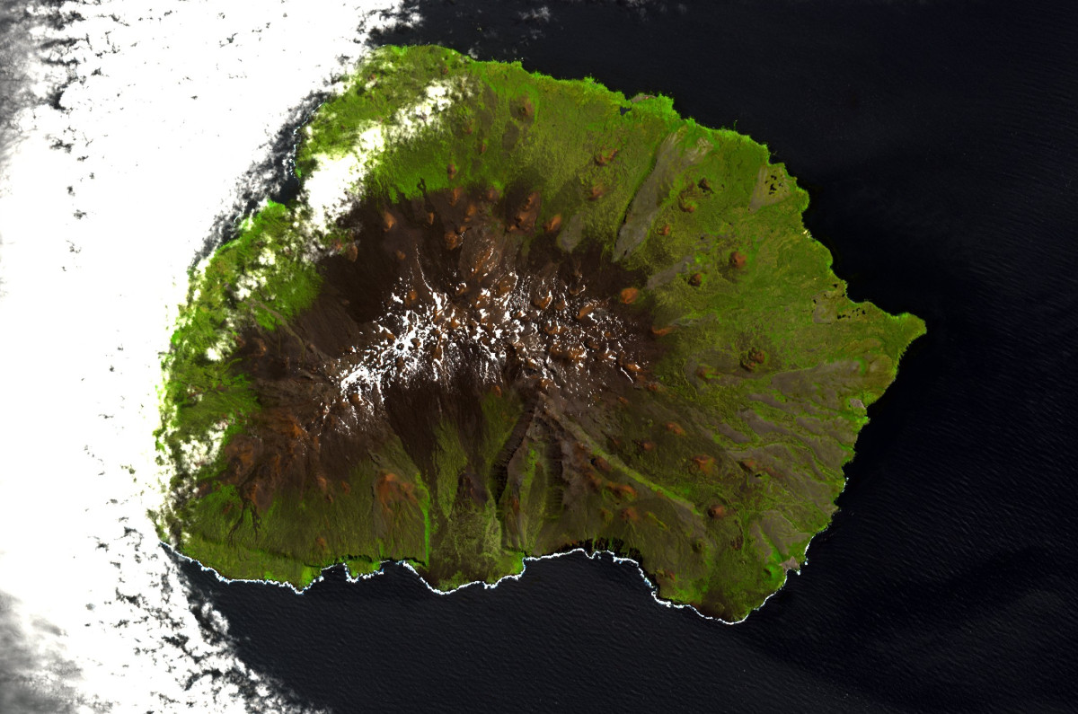
Featured image: NASA Terra ASTER satellite photograph of Marion Island, 26 February 2008, public domain via Wikimedia Commons. The image does not show the entire two-island group and is not current access guidance.

Choose your route: Quick facts · Ten lessons · Worked example · Family learning · Bilingual words
Quick facts for readers
| Question | Reliable starting answer |
|---|---|
| Location? | Subantarctic southern Indian Ocean, administered by South Africa. |
| Which islands? | Marion Island and the smaller Prince Edward Island (not Canada’s province). |
| How formed? | Volcanic geology, modified by oceanic climate and erosion. |
| Research presence? | Marion base, established in 1948; August 2026 reactivation confirmed. |
| Wildlife significance? | Albatrosses, petrels and other ocean-dependent birds and mammals. |
| Protection? | Special Nature Reserve (1995); Ramsar (2007); marine protected area (2009). |
| Public visitation? | Highly restricted research and conservation facilities, not normal tourism. |
Contents: ten things to learn
1. Find two South African islands, not Canada’s province
2. Explore how volcanism built Marion and Prince Edward
3. Understand the westerly winds and the Southern Ocean
4. Study the islands’ albatrosses and other seabirds
5. Explain how house mice became a conservation threat
6. Keep the Mouse-Free Marion project timeline accurate
7. Read the 1947–48 political history and protected designations
8. Understand what the 2026 Marion base interruption teaches
9. Discover why long-term monitoring matters more than a single trip
10. Choose remote learning rather than an imagined public itinerary
Worked maths · Family plan · Glossary · Questions · Sources · Related articles
1. Find two South African islands, not Canada’s province
South Africa’s Prince Edward Islands consist of Marion Island and the smaller Prince Edward Island in the southern Indian Ocean. The South African Department of Forestry, Fisheries and the Environment (DFFE) explains their South African jurisdiction and research importance. The plural name is crucial: this is not Prince Edward Island, the Canadian Atlantic province famous for Charlottetown and Anne of Green Gables.
On a globe, begin with southern Africa, then follow the ocean southeastwards. The two islands sit far from ordinary passenger transport and have very different roles. Marion contains South Africa’s research station; the smaller Prince Edward Island has no permanent staffed station. That physical and operational difference is more informative than describing both as tourist islands.
The NASA image featured on this page shows Marion alone. It is useful for studying its volcanic surface, but it cannot substitute for a map displaying both islands and their legal marine boundary. Reading a caption carefully prevents a true photograph from becoming a false statement about the entire island group.
Try this: Draw a two-island locator and write a sentence that distinguishes this South African group from Canada’s province.
Does the NASA image of Marion display both islands?
No. It depicts Marion Island; Prince Edward Island is a separate nearby island.
← Previous · Contents · Next →
2. Explore how volcanism built Marion and Prince Edward
The DFFE geography account describes both islands as volcanic in origin and notes Marion’s secondary craters, hillocks and small lakes, while the smaller Prince Edward Island has imposing coastal cliffs. This is a useful comparison: two islands formed in the same general volcanic region can still have different erosion patterns, coastline accessibility and habitats.
Look at the island in the NASA Terra ASTER image dated 26 February 2008. The relief appears as a sequence of ridges and slopes. From an aerial image you can ask whether rock and vegetation patterns suggest different landforms, but you cannot determine the age of every lava flow or current seismic risk without appropriate scientific records.
Build a simple model: magma rises, lava forms volcanic rock, later ice, rain, wind and waves reshape the surface. Label those as stages in a conceptual process, not a precise historical reconstruction. A responsible explanation says which observations are visible and which interpretations depend on other evidence.
Try this: Sketch a conceptual volcano cross-section for each island. Mark steep cliffs and lake-bearing terrain as possible distinct features.
Do volcanic islands have identical landscapes once they formed by similar processes?
No. Geological history, erosion, climate and scale lead to substantial differences.
← Previous · Contents · Next →
3. Understand the westerly winds and the Southern Ocean
The islands lie in the path of persistent Southern Ocean winds and fronts. The South African government overview describes boggy moss- and fern-rich ground, substantial precipitation and the strong westerlies often associated with the Roaring Forties. That combination produces very different scenery from a tropical Indian Ocean island.
For geography students, distinguish weather, what is happening at a particular moment, from climate, patterns observed over longer periods. An unusually calm photograph cannot prove the island is usually calm, just as a storm picture does not establish the wind speed every day of the year. Reliable statements need dated observations.
The surrounding sea matters too. Ocean temperatures and currents affect food availability and access conditions. A coastal climate diagram can be compared with measurements farther inland, but only when site exposure and instrument records are understood. This is a good place to learn why a mean hides extremes and why a remote station collects repeated weather data.
Try this: Make a diagram with wind arrows, a wet coastal slope and a lower shelter zone; say what would need measuring.
Would one calm photograph contradict a windy long-term climate description?
No. It describes one observation rather than a multi-year distribution of weather.
← Previous · Contents · Next →
4. Study the islands’ albatrosses and other seabirds
The South African National Antarctic Programme (SANAP) describes the island group as internationally important for seabirds, including albatrosses and petrels. Birds can spend long periods searching the ocean for food and return to land to nest. Protecting the coast alone may therefore miss threats encountered over wide marine foraging areas.
Not all seabird statistics mean the same thing. A count of flying adults differs from a count of occupied nests, eggs or chicks surviving to leave the colony. Birds may also return on different schedules. An old photograph of a spectacular aggregation does not establish that breeding success is improving this year.
Try a simple food-web drawing that links ocean prey to adult birds and then to their chicks. Add labels for the evidence required: tracked trips for movement, nest monitoring for reproduction and marine measurements for environmental context. A scientific claim becomes stronger when you can say what evidence would falsify it as well as what might support it.
Try this: Draw one land–sea food web and write separate observation plans for adult birds and surviving chicks.
Does an albatross sighting measure nesting success?
No. Reproduction needs specific nest and chick observations over time.
← Previous · Contents · Next →
5. Explain how house mice became a conservation threat
Introduced mice on Marion Island are a serious concern because they have been observed attacking living seabirds, including vulnerable albatrosses and petrels. The Mouse-Free Marion project overview explains how changes in predator pressure and ecosystem interactions helped create this problem. Such impacts are very different from a mouse appearing in the background of one expedition photo.
A well-designed study asks which species are affected, when attacks happen, how frequently they occur and whether other causes influence survival. That information is more useful than a dramatic single incident. Seabird chicks can be especially vulnerable because they remain in nests and cannot simply avoid an introduced predator.
For younger learners, this becomes a lesson about islands and evolutionary history: animals that developed in settings without a particular land predator may have fewer effective defences against it. For older learners, explain the causal chain and limitations of experimental interventions. Do not turn it into a claim that all natural predators are bad; the critical issue is harmful introduced species in a specific ecosystem.
Try this: Build a four-box chain: human introduction, mice, vulnerable nesting birds, conservation response.
Does one photograph of a mouse prove its island-wide population or impact?
No. Monitoring is required to estimate distribution and consequences.
← Previous · Contents · Next →
6. Keep the Mouse-Free Marion project timeline accurate
The Mouse-Free Marion project’s 2026 update describes weather monitoring, bait-availability trials and ecological baseline studies, plus a planned 2027 large-scale bait trial covering about 1,050 hectares. That is a future trial within preparation for eradication, not evidence that mice had already been eradicated by October 2026.
This distinction is vital. A project can be well advanced and still be gathering the observations needed for an eventual operation. Researchers must test bait uptake and degradation in different vegetation and climate zones while protecting non-target wildlife. Describing an intended programme as an accomplished restoration would seriously mislead readers.
Compare Macquarie Island, where a separate Australian eradication programme was declared successful in 2014, with Marion’s ongoing work. The goals resemble each other, but their dates, environments, monitoring and regulatory requirements differ. A successful precedent informs research; it does not prove another island has already achieved the same result.
Try this: Write a timeline with 2025 trial, 2026 planning update and 2027 proposed field trial, separating completed and future actions.
Had Marion’s mice already been eradicated by the 2026 project update?
No. The 2026 account describes preparatory work and a planned 2027 large trial.
← Previous · Contents · Next →
7. Read the 1947–48 political history and protected designations
The South African National Antarctic Programme records South Africa’s annexation of Marion Island in December 1947 and Prince Edward Island in January 1948. The research presence on Marion began in 1948. Those dates belong to governance and institutional history; they do not mean the smaller island acquired a town or tourism services.
The same programme describes the islands becoming a Special Nature Reserve in 1995, a Ramsar Wetland of International Importance in 2007 and the surrounding waters being designated a Marine Protected Area in 2009. Each status has a particular purpose and boundary. ‘Ramsar’ records ecological importance; ‘marine protected area’ concerns management of designated waters.
A student might interpret a satellite map as a complete picture of conservation protection, but it does not show legal zones or their conditions. Use the dates above for a timeline, then look for management documents covering the exact activity being discussed. Neither a protected-area title nor historical sovereignty language supplies a visitor permit.
Try this: Create a four-date timeline: 1947, 1948, 1995 and 2009. Add 2007 as a separate wetlands milestone.
Does the designation of a marine protected area create unrestricted access for tourism?
No. Protection is a management regime, often involving tight limits and explicit permissions.
← Previous · Contents · Next →
8. Understand what the 2026 Marion base interruption teaches
The 2026 station chronology is especially important for accurate current information. The South African government’s 27 May 2026 announcement reported a temporary closure after the overwintering team was evacuated because of relief-voyage delays and fuel supply concerns. It would therefore have been wrong to describe the station as operating without interruption throughout 2026.
The 20 August 2026 update then recorded the S.A. Agulhas II arriving on 9 August and reactivation work beginning, with equipment and supplies transferred ashore. Crucially, the 28 August government statement confirmed the station was handed over to the M83 team on 25 August 2026. That is the most useful verified milestone for this article, not a speculative reconstruction.
A remote station can support decades of scientific records while still experiencing an emergency interruption. Learners should separate an institution’s long history from its exact operational status on a specific date. The events also show the importance of logistics, trained personnel, safe transport and redundancy in remote science.
Try this: Make a 2026 chronology with 27 May, 9 August and 25 August, and label what each event actually meant.
Was Marion base continuously open without incident in 2026?
No. Officials documented a temporary closure and later reactivation and handover.
← Previous · Contents · Next →
9. Discover why long-term monitoring matters more than a single trip
The DFFE highlights the scientific value of Marion’s biological and environmental monitoring, including weather, ecological change and interactions among ocean, air and land. Teams work in exceptionally remote conditions so that observations can be compared across years rather than recorded only during occasional visits.
A temperature reading is not a climate trend. A penguin-colony photo is not a population trend. A one-day mouse trap result is not proof of eradication. Each question requires a suitable observation unit, repeatable method, dates and honest uncertainty. When operations pause, scientists document the interruption and assess what instruments could continue automatically.
Develop a study card with four headings: variable, instrument or method, sampling interval and limitation. Try three examples: rainfall in millimetres, breeding nests in a defined plot and mouse detection in standardised grids. All relate to the same island but cannot be compared as if they were the same kind of measurement.
Try this: Choose one environmental question and propose a plausible repeat-observation schedule and limitation.
Can different variables be merged into one generic ‘island health’ number without defining units?
No. An index requires a transparent methodology and meaningful inputs.
← Previous · Contents · Next →
10. Choose remote learning rather than an imagined public itinerary
These two islands are South African protected research and conservation areas, not conventional visitor destinations. The DFFE territory overview and SANAP conservation guidance describe a highly regulated operating environment. The station, researchers and supply voyages do not amount to regular public travel or an authorisation to land.
A precise question is: who wishes to undertake which activity, on which island, under whose written authorisation and biosecurity conditions? An old vessel photograph cannot answer it. Nor can a map of the marine protected area establish a safe voyage, landing route, or legal permissions for wildlife observation.
For families, the more responsible project is a comparative exhibition. Use a two-island map, the 1947–48 and 1995–2009 chronology, an albatross food web, and a properly dated 2026 base update. Add one open scientific question about mice or climate. This is rigorous exploration without inventing a holiday that ordinary readers could not undertake.
Try this: Create a four-panel home-learning display and include one clear warning about permits, biosafety and site-specific permission.
Does a working research base provide general access for tourists?
No. Research operations and public visitor approval are separate matters.
← Previous · Contents · Next →
Worked example: hectares, square kilometres and mismatched sources
Illustrative use of the approximate area figures on the SANAP project profile, not a new land survey. It gives Marion as approximately 29,000 hectares and Prince Edward Island as approximately 4,500 hectares. Add those figures to obtain 33,500 hectares.
There are 100 hectares in one square kilometre. Divide by 100: 33,500 ÷ 100 = 335 square kilometres. Marion’s portion of that approximate sum is 29,000 ÷ 33,500 × 100 ≈ 86.6%. This is an approximate land-area share, not the share of wildlife or protected ocean.
Now read the DFFE description, which reports a different combined total of around 316 km². This is exactly why a careful geography writer identifies sources, measurements and rounding. Do not silently claim these two published estimates match. Differences can reflect revisions or differing source conventions and require investigation before declaring which is the best modern mapped area.
Your final statement should describe the estimate you actually used: “From the approximate SANAP component figures, the simple computed combined area is 335 km².” It is methodologically stronger than pretending that every official publication always agrees.
One-hour family or classroom plan
In the first fifteen minutes, locate the Prince Edward Islands in the southern Indian Ocean, and identify South Africa’s jurisdiction. Ask someone to contrast them with Canadian Prince Edward Island, including the singular and plural names.
Spend fifteen minutes on seabirds and introduced species. Build a model of mice affecting a vulnerable nesting bird, then label which evidence a scientist would need to determine the frequency of those interactions. Use the SANAP project explanation.
In the next fifteen minutes, make a dated history line with 1947, 1948, 1995, 2007 and 2009, then add the 2026 evacuation and reactivation dates. Keep administrative and scientific events in separate colours.
Finish with the approximate area calculation and a discussion of differing official figures. Each person writes one supported claim, one limitation and one question for future scientific work, without proposing an unauthorised landing.
English–Simplified Chinese vocabulary
| English | 简体中文 | Meaning here |
|---|---|---|
| Subantarctic | 亚南极的 | Remote Southern Ocean environment north of high Antarctica. |
| Annexation | 兼并 | Formal political incorporation of a territory. |
| Archipelago | 群岛 | A group of islands. |
| Volcanic origin | 火山成因 | Formation related to volcanism. |
| Ramsar site | 拉姆萨尔湿地 | Wetland designated as internationally important. |
| Seabird colony | 海鸟繁殖群 | A group of seabirds using nesting or breeding habitat. |
| Albatross | 信天翁 | Large ocean-going seabird. |
| Introduced species | 外来引入物种 | Organism brought to a new habitat through human activity. |
| Eradication | 根除 | Planned removal of a species population from a defined site. |
| Biosecurity | 生物安全防护 | Measures preventing harmful biological introductions. |
| Baseline | 基线 | Measurements used for a future comparison. |
| Field trial | 实地试验 | A test carried out under field conditions. |
| Relief voyage | 换防补给航程 | Journey to exchange staff and deliver supplies. |
| Research station | 科研站 | Facility supporting specialist scientific work. |
Frequently asked questions
Are the Prince Edward Islands in Canada?
No. Marion and Prince Edward islands are South African subantarctic territories; Canada’s Prince Edward Island is unrelated.
How many main islands are there?
Two: Marion Island and Prince Edward Island.
Which island hosts the research station?
Marion Island; the smaller Prince Edward Island has no permanent research base.
Are they volcanic?
Yes. Government descriptions identify their volcanic origin.
When did South Africa take control?
SANAP gives December 1947 for Marion and January 1948 for Prince Edward.
What is the Mouse-Free Marion project?
A conservation project preparing to eradicate introduced house mice that threaten seabirds.
Were Marion’s mice already eradicated in 2026?
No. A 2026 update described preparation and further trials planned for 2027.
Why did Marion base close temporarily in 2026?
An official May statement described relief-voyage delays and fuel concerns; the base was reactivated and handed over to M83 in August.
Does the Special Nature Reserve admit ordinary tourists?
No general public tourism entitlement follows from its protected status; activity-specific authorisation is needed.
What makes a good school project?
A two-island map, dated conservation chronology, a seabird food web and a source-based 2026 station update.
Primary sources and further reading
These links document government geography, protected-area classifications, project status and dated 2026 station events. Historical figures remain labelled with their original sources.
South African DFFE: Antarctic and southern ocean islands, Marion geography and science
South African National Antarctic Programme: Mouse-Free Marion and island protected status
Mouse-Free Marion 2026: ongoing field research and planned 2027 trial
South African Government, 27 May 2026: temporary Marion station closure
South African Government, 20 August 2026: base reactivation
South African Government, 28 August 2026: station handed to M83
NASA Terra ASTER Marion 2008 image and public-domain status
Keep learning around the Southern Ocean
Crozet Islands: French volcanic islands and seabirds
Macquarie Island: introduced species and restoration
South Africa: country-learning guide