
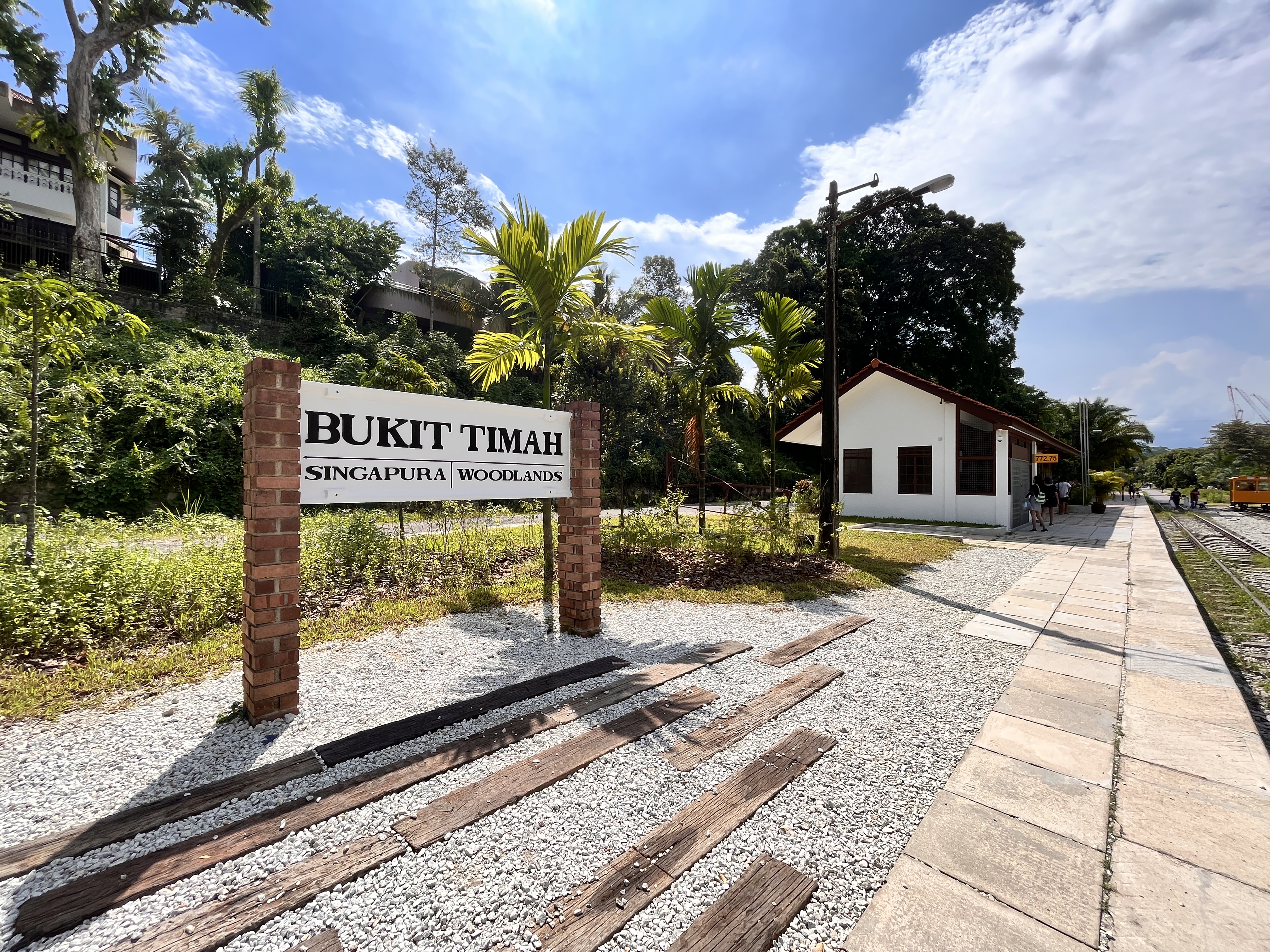
Two small access improvements around the historic Bukit Timah Truss Bridge deserve attention during 2027. The Holland–Bukit Panjang Town Council’s local future-plan list identifies temporary railings and lighting at an existing staircase from Bukit Timah Road, and a new temporary staircase from Rifle Range Road, both leading towards the Bukit Timah Truss Bridge.
These are specific, published neighbourhood intentions, but they are not the same as a new railway station opening or a completed accessible lift. The source does not establish a guaranteed 2027 opening day for either staircase.
The nearby Bukit Timah Railway Station community node has already been open to visitors since 1 July 2022, with its restored station building, staff quarters, gardens and heritage displays. NParks also warns that most of the Rail Corridor remains deliberately unlit at night to protect nocturnal wildlife, even though selected entry points and the station node have lighting.
In this guide
- The 2027 access story in a minute
- Why staircase access matters
- Which truss bridge does the town council mean?
- The Bukit Timah Truss Bridge and its railway history
- What is proposed at the Bukit Timah Road staircase?
- What is proposed at Rifle Range Road?
- Why the two staircase projects are separate
- Does a new staircase provide step-free access?
- The Railway Station community node has been open since 2022
- What is inside the restored station building?
- The former staff quarters and café
- Kampung Garden and Herb and Spice Garden
- A heritage walk can begin without the new stairs
- Why the Rail Corridor is mostly unlit
- Why lighting at one staircase does not mean lighting everywhere
- The difference between Rail Corridor (Central) and North
- The Upper Bukit Timah Truss Bridge is farther north
- What about Hillview Bridge and its lift?
For visitors from King Albert Park, Beauty World, Rifle Range Road, Dunearn Road, Bukit Timah Road and neighbouring estates, the practical question is how to reach the correct part of the Rail Corridor and enjoy it safely without confusing two different historic truss bridges.
This article is based on the Town Council’s April 2025 Bukit Timah future plans, NParks’ Rail Corridor guidance and the 2022 Railway Station community-node opening, reviewed 4 November 2026.
The 2027 access story in a minute
- Existing staircase: Town Council future-plan item 14 identifies temporary railings and lighting at the existing staircase along Bukit Timah Road leading towards Bukit Timah Truss Bridge.
- New temporary staircase: item 15 identifies a proposed staircase at Rifle Range Road providing access towards the same bridge.
- No exact opening date: the April 2025 list does not provide a confirmed 2027 commissioning day for the individual staircase improvements.
- Different bridges: Bukit Timah Truss Bridge near the station and Upper Bukit Timah Truss Bridge near Rail Mall are separate heritage structures.
- Railway Station node: already opened 1 July 2022; it is not awaiting a first-ever opening in 2027.
- Restored heritage: the 1932 station building operates as a heritage gallery, while the former staff quarters accommodates a café, subject to current operating conditions.
- Accessibility: the station community node has barrier-free paths and ramps, but a staircase is not a wheelchair-accessible entrance.
- Trail lighting: the main Rail Corridor is mostly unlit at night, apart from selected paths, entry points and node areas.
- Cycling: follow current NParks path rules, including the Rail Corridor 10 km/h cycling limit and dismount instructions at bridges.
- Before visiting: check current access maps, worksite restrictions and the actual stairway condition rather than assuming a planned entrance is complete.
Why staircase access matters
Visitors may see a Rail Corridor trail on a map and assume they can join it from every adjacent road.
In practice, the trail follows a former railway alignment with embankments, bridges, cuttings and changes in ground level.
An access staircase can make the difference between a safe, designated connection and a tempting informal slope that should not be used.
For local residents, such improvements can connect an ordinary walk to a historical public space.
But the existence of a staircase proposal does not mean people should enter a closed area before it is completed and opened.
Which truss bridge does the town council mean?
The local plan names the Bukit Timah Truss Bridge, approached from Bukit Timah Road and Rifle Range Road near the historic railway-station section.
It is easy to mistake this for the Upper Bukit Timah Truss Bridge farther north near Rail Mall and the Upper Bukit Timah Road corridor.
Both belong to the historic railway landscape, but they have different surrounding roads and access arrangements.
A navigation guide should identify the correct bridge before discussing a proposed staircase.
The names should not be treated as interchangeable simply because each structure has a steel truss form.
The Bukit Timah Truss Bridge and its railway history
The former railway corridor was part of Singapore’s historic rail network linking the island with the wider Malayan railway system.
The station building dates to 1932, and railway tracks and related infrastructure have been preserved to reflect the site’s earlier transport role.
The truss bridges form part of that heritage landscape.
Following the return of the former railway land to Singapore in 2011, public agencies worked to retain important buildings, structures and ecological connections while making the corridor usable for recreation.
Today the area is a public heritage and nature destination, not a working passenger rail station.
What is proposed at the Bukit Timah Road staircase?
The Town Council’s future plan calls for temporary railings and lighting at an existing staircase along Bukit Timah Road leading to the Bukit Timah Truss Bridge.
That suggests a focus on safer access at a particular existing approach.
However, the plan does not establish the precise railing design, lighting hours, length of the affected steps or full 2027 construction sequence.
A resident should not assume the entire main trail becomes illuminated because a staircase entry may receive lights.
If a construction notice appears, check exactly which section of steps is affected and whether a designated alternative route is available.
What is proposed at Rifle Range Road?
A separate future-plan item identifies a new temporary staircase at Rifle Range Road leading towards the bridge.
This concerns a proposed new way to reach an existing heritage route.
The word temporary is important. It describes the nature of the intended access facility rather than a permanent large-scale redevelopment commitment.
A staircase may be useful for many pedestrians, but it is not an accessible ramp or lift for every user.
The exact design, timing and safe public-opening status must be verified when the project is implemented.
Why the two staircase projects are separate
One item concerns modifying an existing staircase with railings and lighting.
The other concerns providing a new temporary staircase at a different approach.
The two features may support a broader walking experience, but finishing one would not automatically mean the other is ready.
A future report should identify which entry has been installed, inspected and opened.
A photograph of the bridge itself is not proof of either staircase’s completion.
This distinction prevents a genuine local improvement plan from turning into an inaccurate claim that every access point has reopened together.
Does a new staircase provide step-free access?
No. By definition, a staircase requires users to negotiate steps.
Visitors using a wheelchair or anyone unable to manage stairs need a suitable alternative access route.
NParks has provided barrier-free improvements at the Bukit Timah Railway Station community node, including ramps connecting conserved buildings and gardens.
That does not mean every approach to the bridge is barrier-free.
The correct method is to inspect current access maps and identify the route suitable for the particular visitor, rather than infer that a planned staircase meets all accessibility needs.
The Railway Station community node has been open since 2022
NParks and URA opened the restored Bukit Timah Railway Station community node on 1 July 2022.
It covers roughly 4.3 hectares and includes the station building, former staff quarters, gardens, lawns and visitor amenities.
The restoration created opportunities to learn about historic rail transport while enjoying an outdoor green corridor.
This is an important distinction for 2027 readers. A site can be already operational while additional local access improvements are still planned.
Do not advertise the station itself as a new 2027 opening because new stairs have been proposed nearby.
What is inside the restored station building?
The conserved station building serves as a railway heritage gallery.
NParks describes restored features including track switching levers, a ticket booth and a replica signals diagram.
Outside are station signs and railway artefacts that help visitors imagine the building’s former role.
Children can learn that a station was once a place where real staff managed rail movements and passengers.
But it is no longer possible to catch a train from the building.
Check current visitor access and operating information rather than assume every interior space is open continuously.
The former staff quarters and café
Across the tracks stands the conserved former staff quarters, repurposed for café use.
It provides one way for visitors to take a break during a heritage walk, subject to the café’s actual operating hours and availability.
A café being part of a community node does not mean all Rail Corridor paths have food or water points at regular intervals.
For a longer walk, plan refreshments based on confirmed facilities rather than assuming a rest stop will be open.
Remember that the station node and the truss bridge are historic public places, while individual commercial businesses follow their own schedules.
Kampung Garden and Herb and Spice Garden
The station community node includes a Kampung Garden and an Herb and Spice Garden.
The first reflects ornamental plants familiar in earlier Singapore neighbourhoods, while the latter contains plants connected with local food and everyday life.
NParks describes examples including hibiscus, jasmine, ginger, laksa leaf and chilli.
These gardens help connect railway history with the changing landscape around it.
They can be useful for children learning how plants enter cooking, culture and community life.
Visitors should not remove plant material or assume everything displayed is safe to eat.
A heritage walk can begin without the new stairs
The proposed temporary access improvements are not the only way to enjoy the Rail Corridor.
Visitors can use already authorised public access routes shown on current NParks maps, subject to conditions and temporary works.
That is important for someone planning an outing in early 2027 before the future-plan items have an official completion notice.
Do not enter a closed staircase or climb an embankment because it appears on an old map.
The existing station community node can provide a meaningful destination independently of the new access project.
Why the Rail Corridor is mostly unlit
The Rail Corridor has an important role as an ecological connection between green spaces.
NParks keeps most sections deliberately unlit at night to support nocturnal wildlife movement.
Lighting is provided at selected access points and the Bukit Timah Railway Station node, but this does not turn the entire trail into a floodlit night-running route.
The agency encourages visitors to leave the main trail before dark, even though general trail access may be described as open at all hours.
A local staircase lighting proposal should be interpreted within that wider ecological policy.
Why lighting at one staircase does not mean lighting everywhere
The Town Council’s plan specifically mentions lighting at an existing access staircase.
A light at a designated entry can help people identify steps or negotiate a local connection more safely.
That is different from installing continuous lighting along the entire Rail Corridor.
Residents should not use the proposed stair light as a reason to advertise nighttime family walks on dark sections of the trail.
For a 2027 visit, follow the site’s current opening, access and safety instructions.
An ecological corridor often balances human convenience with the needs of wildlife.
The difference between Rail Corridor (Central) and North
NParks describes Rail Corridor (Central) as the notable stretch between Hillview and the conserved Bukit Timah Railway Station.
Rail Corridor (North) continues through the Hillview area and beyond towards Kranji, with its own bridges and access nodes.
The geography matters when interpreting a visitor map.
A statement about a lift at Hillview Bridge does not establish a lift at the Bukit Timah Truss Bridge.
Likewise, the popular Upper Bukit Timah Truss Bridge near Rail Mall has different nearby amenities from the station’s truss bridge.
The Upper Bukit Timah Truss Bridge is farther north
NParks’ Rail Corridor (North) guidance identifies the Upper Bukit Timah Truss Bridge near Rail Mall, along with a scenic lookout and other access arrangements.
The agency describes direct connections from nearby pedestrian infrastructure to the Rail Mall area.
Those are useful existing visitor details, but they should not be copied into the future-plan item about Rifle Range Road and the Bukit Timah Road staircase.
An accurate route guide should name the precise bridge and access road.
This avoids sending visitors to the wrong entrance when they are following a new works notice.
What about Hillview Bridge and its lift?
NParks describes Hillview Bridge as wheelchair accessible, with a lift connection near Hillview MRT Exit B.
That is a real accessibility feature at a particular site.
It does not establish a corresponding lift at every truss bridge.
A wheelchair user should select a confirmed accessible route based on the actual destination.
Maps are most helpful when they state not just where the trail runs, but where people can enter it safely with their mobility requirements.
Trail surfaces and footwear
Different Rail Corridor sections can have grass, gravel, porous paths or other surfaces designed to retain the corridor’s rustic character.
The best footwear depends on the intended route, weather and the visitor’s comfort.
Wet surfaces may become slippery even if a path is generally open.
A person using a stroller or mobility aid should check the relevant surface and slope information before choosing an itinerary.
The presence of a paved section near the station should not be read as proof that every kilometre of the corridor has an identical finish.
Cycling rules near heritage bridges
NParks states a 10 km/h speed limit for cyclists on the Rail Corridor and emphasises giving way to pedestrians.
Cyclists are instructed to dismount at bridges and other indicated locations.
That matters where bridges are narrow and visitors may stop to admire the scenery or take photographs.
The restoration of a truss bridge does not turn it into a dedicated high-speed cycling track.
Follow current signs at the specific bridge and respect other visitors’ space.
For details, see Bukit Timah 2027 cycling and mobility rules.
Why people should not climb the bridge structure
The historic steel truss is a protected architectural feature, not a climbing frame.
Visitors can appreciate its form and heritage without touching unsafe parts, crossing barriers or balancing on rails.
Photography should be conducted from the authorised public path.
A person standing in the middle of a narrow bridge should also consider others needing to pass.
The safest experience respects both the heritage structure and the people using it.
Keeping children safe during a Rail Corridor visit
Before entering, explain to younger children that the route is a shared path, not an enclosed playground.
They may encounter cyclists, runners and other walkers.
At bridges or steps, an adult should supervise movement according to the child’s abilities and the actual site conditions.
A child should know not to leave the marked trail or run towards a closed staircase.
It is easier to teach the rules calmly at the start than to explain them for the first time near an exposed edge.
Planning for older visitors
An older visitor may enjoy the restored station gallery but find a long walk or steep staircase uncomfortable.
The best itinerary need not include every truss bridge.
Select a shorter route with confirmed accessible entry and rest facilities.
Where the person requires step-free access, verify that the exact route—not merely the destination node—meets that requirement.
Do not assume a new temporary staircase at Rifle Range Road would solve an access problem for someone unable to climb steps.
What happens during a worksite closure?
If a staircase improvement starts, the responsible authority may temporarily restrict that approach.
Follow the official signs and use another authorised route.
Do not use an informal dirt slope or move fencing to reach the trail more quickly.
For families with strollers or people using mobility aids, an alternative route must be evaluated for the whole journey.
A contractor’s sign should identify the affected section and any enquiry contact.
Do not describe every neighbouring bridge as closed merely because one approach is under work.
How to verify that a staircase is ready
A useful completion notice should name the staircase, the road approach and the actual public-opening conditions.
A recently installed railing or visible lights can be evidence of progress but does not establish that a temporary structure has passed inspection.
Check for ongoing barriers and follow site instructions.
Photographs should have a truthful location and date. A picture of the restored station building should not be labelled as the newly completed Rifle Range staircase.
When unsure, use current NParks visitor information and the relevant project authority’s announcement.
An important difference: Rifle Range Road versus Rifle Range Nature Park
Rifle Range Road is a street and access context for the proposed temporary staircase.
Rifle Range Nature Park is a separate NParks destination with its own visitor facilities and routes.
A future-plan item mentioning Rifle Range Road does not mean the staircase is a new entrance to every trail in Rifle Range Nature Park.
Visitors should check the actual location and approved access.
This is particularly important when planning a route with children or someone who cannot manage a steep climb.
Weather, thunderstorms and trail conditions
The Rail Corridor passes through outdoor natural areas.
Heavy rain, lightning and strong wind can create hazards, especially where the path is exposed or surfaces are slippery.
A railing does not make it safe to remain on a bridge during a thunderstorm.
Plan to leave before dark and adjust the visit when the weather turns unsafe.
Do not use a worksite to shelter from rain or enter closed structures.
The safety of people takes priority over completing a planned scenic walk.
Respecting wildlife along the trail
The corridor supports biodiversity and connects important green spaces.
Visitors should stay on the permitted path, avoid feeding wildlife and not remove plants or animals.
The unlit nighttime conditions are part of that ecological purpose.
A child can learn to observe birds or vegetation without disturbing them.
An improved staircase can make access easier while preserving the surrounding natural environment.
That is the intended balance of thoughtful recreation infrastructure.
A lesson in how a city preserves heritage
The restored station and truss bridges show that old transport infrastructure can acquire a new public purpose.
A railway once carried passengers and goods. Its former land now supports walking, nature appreciation and community activities.
Restoration requires retaining historical evidence while making some features safe for modern use.
The proposed temporary access improvements show that the work of making a heritage place convenient may continue after its main restoration.
This is a useful connection between local history and urban planning.
A family educational activity
Ask a child to identify three different kinds of features: railway heritage, nature and modern access infrastructure.
The old station sign represents transport history. Plants beside the path belong to the ecological landscape. A modern ramp or staircase supports public movement.
Then ask which features are already open and which appear only in the council’s future plan.
The child learns to distinguish observation, historical evidence and planning intention.
This activity can be completed from a safe public route without entering an unfinished work area.
A 2027 resident monitoring plan
Before a visit: check current NParks Rail Corridor maps and any closures around the station and bridge.
During 2027: look for a detailed work notice for the Bukit Timah Road existing staircase and the separate Rifle Range Road temporary staircase.
If construction begins: use only designated alternate entrances and observe accessibility needs.
After one project finishes: verify which staircase has actually opened and whether the other remains pending.
For future events: use NParks’ current community-node and trail notices, rather than assume a dated event is recurring.
This is a practical routine, not an invented government schedule of quarterly openings.
Frequently asked questions
Are two staircase improvements planned near Bukit Timah Truss Bridge?
Yes. The council lists railings and lighting on an existing Bukit Timah Road staircase and a new temporary staircase from Rifle Range Road.
Do both have a confirmed 2027 completion date?
No. The April 2025 future-plan list does not establish a guaranteed exact opening date for either feature.
Has Bukit Timah Railway Station reopened?
Yes. The restored Railway Station community node opened in July 2022.
Can visitors catch trains at the station?
No. The former station is a heritage destination, not an operating passenger railway service.
Is the Bukit Timah Truss Bridge the same as the Upper Bukit Timah Truss Bridge?
No. They are distinct railway heritage structures along different parts of the corridor.
Does a new staircase mean a wheelchair-accessible entrance?
No. Step-free access requires a separate confirmed suitable route.
Is the Rail Corridor illuminated at night?
Most sections remain unlit to protect nocturnal wildlife, and NParks encourages visitors to leave before dark.
Can visitors cycle across the bridge at speed?
NParks sets a 10 km/h cycling limit on the Rail Corridor and requires dismounting on bridges and where indicated.
Where can families find accessible toilets near the historic station?
NParks describes public restrooms at the restored Bukit Timah Railway Station community node. Check the current visitor information for opening and access details.
Where should residents check current project status?
Use the Town Council’s future-plan record, actual worksite notices and NParks’ current Rail Corridor information.
Official sources and related Bukit Timah reading
- Holland–Bukit Panjang Town Council: Bukit Timah Truss Bridge access improvements, items 14 and 15
- NParks: Rail Corridor North, visitor access and trail safety
- NParks/URA: Bukit Timah Railway Station heritage community-node opening, July 2022
- NParks/URA: Rail Corridor Central heritage bridges and access improvements
- URA: Rail Corridor identity and heritage
- eduKateSG: Earlier Bukit Timah truss bridge staircase proposal
- eduKateSG: Bukit Timah 2027 green elevated corridor
- eduKateSG: Railway Station and Nine Mile Platform heritage
- eduKateSG: Bukit Timah 2027 active mobility and path rules
The takeaway: The council has identified two access improvements near Bukit Timah Truss Bridge, but neither has a confirmed public opening day in 2027. The restored Railway Station and Rail Corridor already provide substantial heritage and nature experiences. Visitors should use the correct bridge and approved entry route, with care around stairs, cycling rules and unlit trails.