
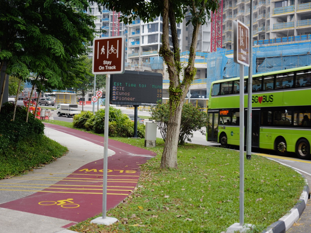

Bukit Timah’s cycling and walking paths help connect homes, schools, bus stops and MRT stations. This original October 2026 photograph shows a shared cycling and pedestrian lane. Singapore’s rules distinguish shared paths, footpaths, dedicated cycling paths and Pedestrian-Only Paths. Since July 2025, certain footpaths next to dedicated cycling paths have been designated for pedestrians, so the correct behaviour depends on the markings at the exact location.
LTA’s current guidance tells riders to give way to pedestrians, slow near bus stops and intersections, dismount where required and use suitable lights in the dark. The photograph is a useful visual record, not a live route-safety certificate. Families should check the full home-to-school journey before deciding whether a child should walk, cycle or use public transport.
Quick facts and 2026 safety rules
- Photo: eduKateSG media 280752, uploaded 19 October 2026.
- Area: Bukit Timah, within the Beauty World–Upper Bukit Timah education corridor.
- Rules: the Active Mobility Act and LTA’s current code of conduct govern public-path use.
- From July 2025: designated Pedestrian-Only Paths beside cycling paths have separate restrictions.
- Speed limits reported February 2026: 10 km/h on footpaths and 25 km/h on shared paths; ride more slowly when conditions require.
- Safety: give way, keep appropriate distance, use crossings and dismount when directed.
- School route: verify the complete home-to-gate path and school bicycle rules.
1. The original October 2026 path photograph
The featured image is catalogued as a shared cycling and pedestrian lane in Bukit Timah. It records visible path infrastructure in the district, not a guaranteed uninterrupted cycle route to a particular school. A single viewpoint cannot establish the legal classification of every adjoining segment. Riders and walkers should read the markings and signs actually present at each location.
An effective route study begins with the path’s legal category. The presence of painted lines or a nearby cycling symbol does not prove that every adjoining surface has the same rules. Use the latest LTA guide and the markings on the ground. Record where a path changes category, because a rider may need to alter behaviour within a very short distance.
For the October 2026 Bukit Timah photograph, the practical question is whether a user can recognise the relevant rule and apply it at the actual location. The image documents a moment in the streetscape; current LTA guidance, path markings and on-site conditions determine safe and lawful behaviour.
2. Three different path categories
Singapore distinguishes footpaths, shared paths and dedicated cycling paths, with different permitted uses. From July 2025, some footpaths next to cycling paths were converted to Pedestrian-Only Paths. LTA states that this initiative does not apply to standalone footpaths or shared paths in the same way. It is important not to describe every red or marked strip as the same legal category.
Consider the most vulnerable person who might use the space. A child walking in a group, an older pedestrian or someone using a mobility aid may need more room and time. A rider’s obligation to give way is meaningful only if speed and spacing make it possible. Students can explain this in terms of reaction time and predictability rather than simply repeating a slogan about courtesy.
For the October 2026 Bukit Timah photograph, the practical question is whether a user can recognise the relevant rule and apply it at the actual location. The image documents a moment in the streetscape; current LTA guidance, path markings and on-site conditions determine safe and lawful behaviour.
3. What changed in July 2025
The Pedestrian-Only Paths initiative was introduced to improve safety, particularly for children and seniors, where dedicated cycling paths run alongside pedestrian space. The converted paths use signs and markings to tell users which side is intended for walking. A cyclist who ignores the distinction may create risk even when travelling at modest speed.
A school route should be mapped from the actual home entrance to the designated gate. Include the road crossings, junctions, bus stops and places where the rider may have to dismount. A short path photographed near Beauty World is not proof that the entire commute is safe. A parent should rehearse the route and have a practical alternative when conditions change.
For the October 2026 Bukit Timah photograph, the practical question is whether a user can recognise the relevant rule and apply it at the actual location. The image documents a moment in the streetscape; current LTA guidance, path markings and on-site conditions determine safe and lawful behaviour.
4. The Active Mobility Act and current rules
The Active Mobility Act governs bicycles and other active mobility devices on public paths. LTA’s current rules page is the right source for permitted devices, speed limits and rider responsibilities. Legal rules can change, so a school guide should link to the live authority rather than reproduce an old poster without a date.
Use a source grid with columns for photographed observation, current rule and remaining uncertainty. The image can show a path and nearby streetscape. LTA can establish the relevant law. A claim about the current surface condition or school parking requires a fresh check. This method prevents a visual impression from becoming a legal conclusion.
For the October 2026 Bukit Timah photograph, the practical question is whether a user can recognise the relevant rule and apply it at the actual location. The image documents a moment in the streetscape; current LTA guidance, path markings and on-site conditions determine safe and lawful behaviour.
5. The difference between cycling and walking speed
A person on a bicycle can close a gap much faster than a pedestrian expects. That difference matters near bus stops, shops, crossings and school gates. Safe riding involves speed appropriate to the surroundings, not merely staying below a maximum. LTA advises slowing near other users and walking the bicycle through crowded places.
A numerical exercise should state distance, speed and assumptions. Dividing distance by speed gives theoretical moving time, not the full door-to-door journey. A rider may need to wait at crossings, dismount or slow around pedestrians. Students should include those missing variables when discussing why a model differs from reality.
For the October 2026 Bukit Timah photograph, the practical question is whether a user can recognise the relevant rule and apply it at the actual location. The image documents a moment in the streetscape; current LTA guidance, path markings and on-site conditions determine safe and lawful behaviour.
6. Current speed limits as of 2026
The Ministry of Transport’s February 2026 reply states that cyclists must keep within 10 km/h on footpaths and 25 km/h on shared paths. These are maximums, not targets for crowded conditions. Pedestrian-only paths are governed by separate restrictions. Riders should check the actual path category and latest LTA guidance before deciding what is permitted.
A safe learning walk should not interfere with the path being studied. Observe from a suitable public position, follow signs and avoid photographing identifiable people. The objective is to learn how infrastructure works, not to count or judge individual users. A clear sketch and a dated note can be more valuable than an intrusive photo.
For the October 2026 Bukit Timah photograph, the practical question is whether a user can recognise the relevant rule and apply it at the actual location. The image documents a moment in the streetscape; current LTA guidance, path markings and on-site conditions determine safe and lawful behaviour.
7. Giving way to vulnerable users
LTA’s code of conduct asks active mobility riders to give way to pedestrians, watch their speed and maintain safe distances. A schoolchild, an older person and a wheelchair user may respond differently to a rapidly approaching bicycle. Courtesy is not an optional decoration: it makes a shared route more predictable.
Compare the route with a parallel pedestrian-only section where one exists. Explain why separating faster and slower users can reduce conflict while still requiring caution at crossings and intersections. The policy is about coordinating different movement needs, not declaring that one group owns every public space.
For the October 2026 Bukit Timah photograph, the practical question is whether a user can recognise the relevant rule and apply it at the actual location. The image documents a moment in the streetscape; current LTA guidance, path markings and on-site conditions determine safe and lawful behaviour.
8. Why a bus stop is a conflict point
People approaching a bus stop may step toward a shelter, queue or turn suddenly to board. Riders should slow down near such places and be ready to stop. The October Bukit Timah photo series also contains roadside bus-stop images near Beauty World, showing why path safety should be considered alongside public transport rather than in isolation.
Finish each topic with a concrete decision: should the rider slow, give way, dismount, check a sign or choose another route? The right action depends on the actual path and conditions. An informative article helps a student recognise the decision point without claiming that a photograph is a live safety inspection.
For the October 2026 Bukit Timah photograph, the practical question is whether a user can recognise the relevant rule and apply it at the actual location. The image documents a moment in the streetscape; current LTA guidance, path markings and on-site conditions determine safe and lawful behaviour.
9. The correct behaviour at crossings
LTA requires riders to stop and look out for traffic before crossing roads. Crossing designs and signs determine whether riding or dismounting is appropriate. A cyclist should not treat a marked pedestrian crossing as a guarantee that drivers have seen them. Children need supervised practice in interpreting signals and waiting safely.
An effective route study begins with the path’s legal category. The presence of painted lines or a nearby cycling symbol does not prove that every adjoining surface has the same rules. Use the latest LTA guide and the markings on the ground. Record where a path changes category, because a rider may need to alter behaviour within a very short distance.
For the October 2026 Bukit Timah photograph, the practical question is whether a user can recognise the relevant rule and apply it at the actual location. The image documents a moment in the streetscape; current LTA guidance, path markings and on-site conditions determine safe and lawful behaviour.
10. No Riding signs and dismounting
A No Riding sign means the rider should get off and push the device, subject to applicable rules and exceptions. This is especially important where path space narrows or pedestrian movement becomes dense. A school journey should never depend on ignoring a restriction to save a few seconds.
Consider the most vulnerable person who might use the space. A child walking in a group, an older pedestrian or someone using a mobility aid may need more room and time. A rider’s obligation to give way is meaningful only if speed and spacing make it possible. Students can explain this in terms of reaction time and predictability rather than simply repeating a slogan about courtesy.
For the October 2026 Bukit Timah photograph, the practical question is whether a user can recognise the relevant rule and apply it at the actual location. The image documents a moment in the streetscape; current LTA guidance, path markings and on-site conditions determine safe and lawful behaviour.
11. Lights and visibility
LTA requires front white and rear red lights when riding in the dark. The rule addresses visibility, but lights should not be directed into other users’ faces. Bright clothing and predictable movements may help, yet they do not replace careful speed, braking and awareness at junctions.
A school route should be mapped from the actual home entrance to the designated gate. Include the road crossings, junctions, bus stops and places where the rider may have to dismount. A short path photographed near Beauty World is not proof that the entire commute is safe. A parent should rehearse the route and have a practical alternative when conditions change.
For the October 2026 Bukit Timah photograph, the practical question is whether a user can recognise the relevant rule and apply it at the actual location. The image documents a moment in the streetscape; current LTA guidance, path markings and on-site conditions determine safe and lawful behaviour.
12. Helmet rules differ by setting
LTA’s rules distinguish cycling on roads from riding on public paths. Cyclists on roads must wear helmets. Families should check the current requirements for the specific route and consider suitable protective equipment for children. A photograph of a path cannot establish that a particular rider is following every rule.
Use a source grid with columns for photographed observation, current rule and remaining uncertainty. The image can show a path and nearby streetscape. LTA can establish the relevant law. A claim about the current surface condition or school parking requires a fresh check. This method prevents a visual impression from becoming a legal conclusion.
For the October 2026 Bukit Timah photograph, the practical question is whether a user can recognise the relevant rule and apply it at the actual location. The image documents a moment in the streetscape; current LTA guidance, path markings and on-site conditions determine safe and lawful behaviour.
13. Why a child’s school commute needs a route audit
A parent considering cycling to school should assess the entire home-to-gate journey. One attractive shared path may end at a busy road or require a difficult crossing. The route should be rehearsed with appropriate supervision and checked for signs, gradients, traffic and safe bicycle parking at the destination.
A numerical exercise should state distance, speed and assumptions. Dividing distance by speed gives theoretical moving time, not the full door-to-door journey. A rider may need to wait at crossings, dismount or slow around pedestrians. Students should include those missing variables when discussing why a model differs from reality.
For the October 2026 Bukit Timah photograph, the practical question is whether a user can recognise the relevant rule and apply it at the actual location. The image documents a moment in the streetscape; current LTA guidance, path markings and on-site conditions determine safe and lawful behaviour.
14. School gates and crowding
Arrival and dismissal periods create concentrated pedestrian movement. A path that feels spacious at midday may be crowded when pupils leave. Riders should reduce speed and be prepared to walk their bicycles near school entrances. The exact gate and school rules matter; no generic Bukit Timah photo can establish them for every campus.
A safe learning walk should not interfere with the path being studied. Observe from a suitable public position, follow signs and avoid photographing identifiable people. The objective is to learn how infrastructure works, not to count or judge individual users. A clear sketch and a dated note can be more valuable than an intrusive photo.
For the October 2026 Bukit Timah photograph, the practical question is whether a user can recognise the relevant rule and apply it at the actual location. The image documents a moment in the streetscape; current LTA guidance, path markings and on-site conditions determine safe and lawful behaviour.
15. The first and last kilometre
Walking and cycling can connect homes to MRT stations or bus stops, but the path must be continuous, safe and appropriate to the user. A rail station is only one part of a student’s journey. The final crossing and the correct school gate may be more important than the distance along the most attractive path segment.
Compare the route with a parallel pedestrian-only section where one exists. Explain why separating faster and slower users can reduce conflict while still requiring caution at crossings and intersections. The policy is about coordinating different movement needs, not declaring that one group owns every public space.
For the October 2026 Bukit Timah photograph, the practical question is whether a user can recognise the relevant rule and apply it at the actual location. The image documents a moment in the streetscape; current LTA guidance, path markings and on-site conditions determine safe and lawful behaviour.
16. An original speed and time calculation
If a hypothetical cyclist travels 2 kilometres at a constant 10 km/h, the theoretical time is 2 ÷ 10 hours, or 12 minutes. At 8 km/h it is 15 minutes. These are mathematical models, not actual Bukit Timah travel times. Stops, crossings and the need to dismount can make real journeys longer.
Finish each topic with a concrete decision: should the rider slow, give way, dismount, check a sign or choose another route? The right action depends on the actual path and conditions. An informative article helps a student recognise the decision point without claiming that a photograph is a live safety inspection.
For the October 2026 Bukit Timah photograph, the practical question is whether a user can recognise the relevant rule and apply it at the actual location. The image documents a moment in the streetscape; current LTA guidance, path markings and on-site conditions determine safe and lawful behaviour.
17. An original stopping-distance discussion
A faster moving bicycle generally requires more distance and time to stop. Actual stopping distance depends on reaction, brakes, surface and conditions. Students can explore the idea using a supervised low-speed experiment in a safe area, but should not conduct risky braking tests on busy public paths. The science lesson is that speed affects safety even when a rider believes they are in control.
An effective route study begins with the path’s legal category. The presence of painted lines or a nearby cycling symbol does not prove that every adjoining surface has the same rules. Use the latest LTA guide and the markings on the ground. Record where a path changes category, because a rider may need to alter behaviour within a very short distance.
For the October 2026 Bukit Timah photograph, the practical question is whether a user can recognise the relevant rule and apply it at the actual location. The image documents a moment in the streetscape; current LTA guidance, path markings and on-site conditions determine safe and lawful behaviour.
18. A hypothetical weekly commuting model
Suppose a child saves six minutes on each one-way journey by cycling rather than walking. Across five school days with two journeys each day, the theoretical saving is 6 × 10 = 60 minutes. The result is not a reason to choose cycling if the route is unsafe. Time savings should be weighed against supervision, weather, equipment and fatigue.
Consider the most vulnerable person who might use the space. A child walking in a group, an older pedestrian or someone using a mobility aid may need more room and time. A rider’s obligation to give way is meaningful only if speed and spacing make it possible. Students can explain this in terms of reaction time and predictability rather than simply repeating a slogan about courtesy.
For the October 2026 Bukit Timah photograph, the practical question is whether a user can recognise the relevant rule and apply it at the actual location. The image documents a moment in the streetscape; current LTA guidance, path markings and on-site conditions determine safe and lawful behaviour.
19. Why shared paths are social infrastructure
A path is a public resource used by people with different speeds, abilities and purposes. Its success depends on design, markings, maintenance and user behaviour. A cycling route may support exercise and local accessibility, while a pedestrian-only section protects more vulnerable walkers. The city needs both functions coordinated.
A school route should be mapped from the actual home entrance to the designated gate. Include the road crossings, junctions, bus stops and places where the rider may have to dismount. A short path photographed near Beauty World is not proof that the entire commute is safe. A parent should rehearse the route and have a practical alternative when conditions change.
For the October 2026 Bukit Timah photograph, the practical question is whether a user can recognise the relevant rule and apply it at the actual location. The image documents a moment in the streetscape; current LTA guidance, path markings and on-site conditions determine safe and lawful behaviour.
20. The role of schools in safety education
LTA and schools promote safe path behaviour through education and outreach. Children benefit from learning signs, giving way, predictable movement and what to do after a near miss. A safety lesson is more useful when it involves real route observations and discussion than when it asks pupils to memorise rules without understanding the risks.
Use a source grid with columns for photographed observation, current rule and remaining uncertainty. The image can show a path and nearby streetscape. LTA can establish the relevant law. A claim about the current surface condition or school parking requires a fresh check. This method prevents a visual impression from becoming a legal conclusion.
For the October 2026 Bukit Timah photograph, the practical question is whether a user can recognise the relevant rule and apply it at the actual location. The image documents a moment in the streetscape; current LTA guidance, path markings and on-site conditions determine safe and lawful behaviour.
21. Cycling is not the same as a fitness test
A student may enjoy cycling for recreation without being ready to commute independently. Riding skill, road judgement and the ability to handle unexpected situations develop at different rates. Families should avoid treating cycling to school as a status symbol or a compulsory sign of maturity. A safe walk or bus journey may be more suitable.
A numerical exercise should state distance, speed and assumptions. Dividing distance by speed gives theoretical moving time, not the full door-to-door journey. A rider may need to wait at crossings, dismount or slow around pedestrians. Students should include those missing variables when discussing why a model differs from reality.
For the October 2026 Bukit Timah photograph, the practical question is whether a user can recognise the relevant rule and apply it at the actual location. The image documents a moment in the streetscape; current LTA guidance, path markings and on-site conditions determine safe and lawful behaviour.
22. Weather and surface conditions
Rain can reduce visibility and make surfaces slippery. Wet leaves, debris and puddles can change the way a bicycle handles. Families should have an alternative route or mode of travel when conditions are unsuitable. A photo taken on one October day cannot establish the condition of the path during a later storm.
A safe learning walk should not interfere with the path being studied. Observe from a suitable public position, follow signs and avoid photographing identifiable people. The objective is to learn how infrastructure works, not to count or judge individual users. A clear sketch and a dated note can be more valuable than an intrusive photo.
For the October 2026 Bukit Timah photograph, the practical question is whether a user can recognise the relevant rule and apply it at the actual location. The image documents a moment in the streetscape; current LTA guidance, path markings and on-site conditions determine safe and lawful behaviour.
23. Parking bicycles responsibly
LTA advises parking at designated racks or marked areas and securing bicycles appropriately. An abandoned bicycle can obstruct a footpath or block access for wheelchair users. A school should be consulted about bicycle storage and entry arrangements before a student starts commuting by cycle.
Compare the route with a parallel pedestrian-only section where one exists. Explain why separating faster and slower users can reduce conflict while still requiring caution at crossings and intersections. The policy is about coordinating different movement needs, not declaring that one group owns every public space.
For the October 2026 Bukit Timah photograph, the practical question is whether a user can recognise the relevant rule and apply it at the actual location. The image documents a moment in the streetscape; current LTA guidance, path markings and on-site conditions determine safe and lawful behaviour.
24. An observational fieldwork method
From a safe public viewpoint, identify markings, signs, junctions, bus stops and changes in path width. Do not stand in the cycling lane to take photographs or record identifiable children. Make a simple map showing where a rider should slow or dismount, then check each interpretation against current LTA guidance.
Finish each topic with a concrete decision: should the rider slow, give way, dismount, check a sign or choose another route? The right action depends on the actual path and conditions. An informative article helps a student recognise the decision point without claiming that a photograph is a live safety inspection.
For the October 2026 Bukit Timah photograph, the practical question is whether a user can recognise the relevant rule and apply it at the actual location. The image documents a moment in the streetscape; current LTA guidance, path markings and on-site conditions determine safe and lawful behaviour.
25. A seven-day learning project
Day one label the original photo. Day two identify path categories. Day three read the July 2025 Pedestrian-Only Paths rules. Day four calculate two hypothetical travel times. Day five map a safe crossing. Day six discuss vulnerable path users. Day seven prepare a short school-route safety guide with verified rules and explicit uncertainties.
An effective route study begins with the path’s legal category. The presence of painted lines or a nearby cycling symbol does not prove that every adjoining surface has the same rules. Use the latest LTA guide and the markings on the ground. Record where a path changes category, because a rider may need to alter behaviour within a very short distance.
For the October 2026 Bukit Timah photograph, the practical question is whether a user can recognise the relevant rule and apply it at the actual location. The image documents a moment in the streetscape; current LTA guidance, path markings and on-site conditions determine safe and lawful behaviour.
Frequently asked questions
Is every path in Bukit Timah shared?
No. Footpaths, shared paths, cycling paths and Pedestrian-Only Paths have different rules.
What changed in July 2025?
Certain footpaths adjacent to cycling paths were designated Pedestrian-Only Paths.
Can cyclists ride on Pedestrian-Only Paths?
Generally no, subject to specific statutory exceptions. Check current LTA rules.
What are the speed limits?
MOT’s February 2026 guidance cites 10 km/h on footpaths and 25 km/h on shared paths for cyclists.
Should cyclists give way to pedestrians?
Yes. LTA advises giving way and slowing around vulnerable users.
Must riders dismount at No Riding signs?
Yes, follow the posted restriction and applicable rules.
Is the photo a complete school cycling route?
No. It is one dated path image.
What if it rains?
Assess surface and visibility and choose a safer alternative if needed.
Can a student cycle to any school?
Check the child’s readiness, safe route and the individual school’s access and bicycle arrangements.
Official rules and connected local reading
- LTA rules and code of conduct
- MOT February 2026 speed and enforcement reply
- MOT October 2025 path safety reply
- Bukit Timah walking and cycling upgrades
- Jalan Jurong Kechil bus stop photo
- Clementi Mathematics learning reference
Independent October 2026 photo-led safety and education guide. Path classifications, rules and diversions should be checked against current LTA notices and on-site markings. Do not treat the photograph as proof of the condition of an entire route.