
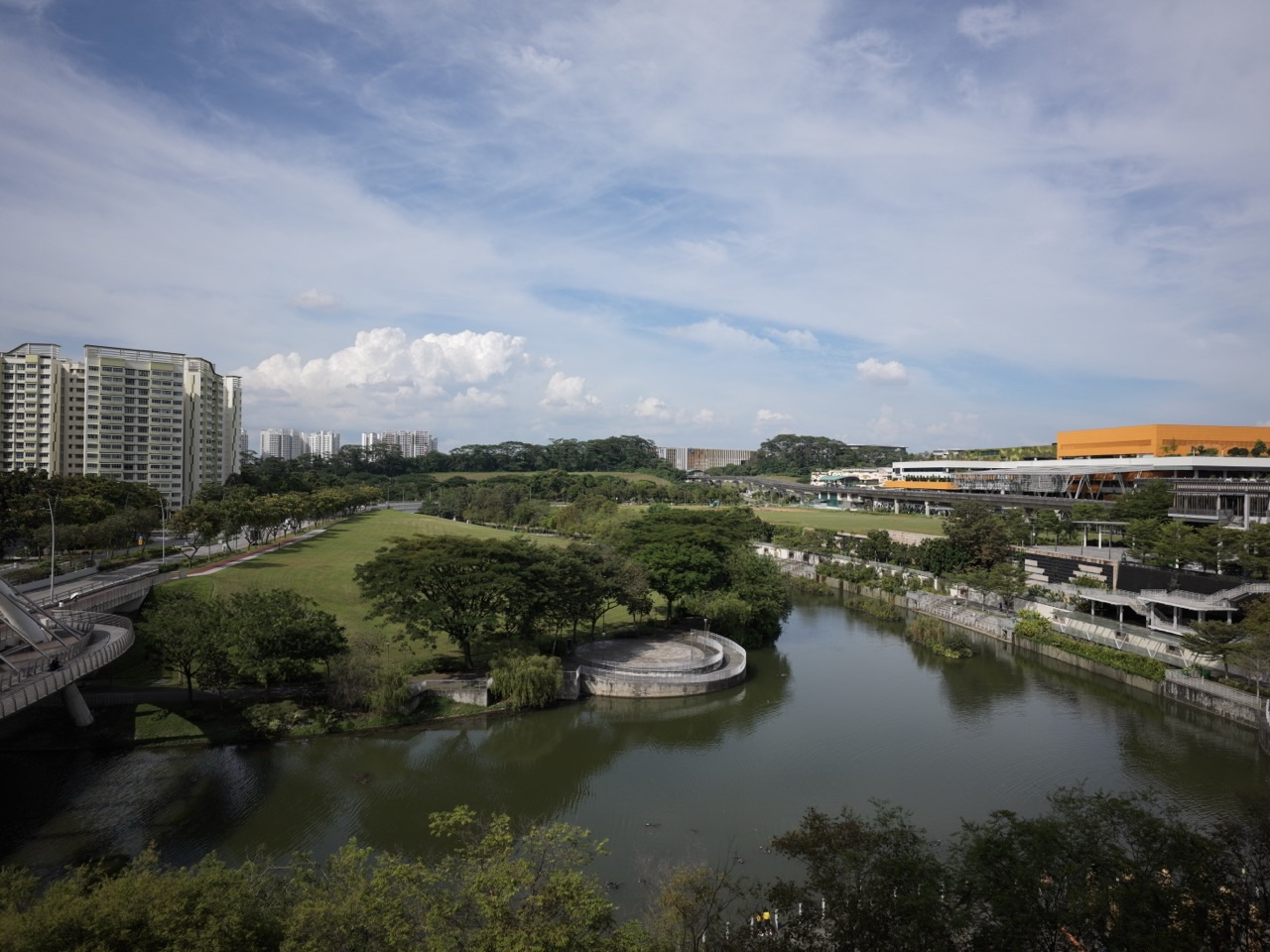
Sumang LRT Station (PW6) is a useful Punggol West Loop stop for neighbourhood food, waterway-side architecture and a short local walk. Near the station are Waterway Cascadia and Waterway Terraces I, shops and coffee shops including the Foodgle food-court area, and publicly accessible pedestrian links leading towards the wider Punggol Waterway neighbourhood. The name Sumang also has a real historical connection to Wak Sumang, whose fishing settlement was at Punggol Point.
This LRT guide explains where to go near Sumang, what to do without invading residents’ privacy, how to find a casual meal, which exits serve different parts of the precinct, and how the modern town connects to an older part of Singapore’s history. It is intended for families, residents and first-time visitors who prefer accurate, practical advice over exaggerated attractions.
The most rewarding simple visit is to choose one neighbourhood eating place and add a short public-path walk with views of the Waterway West housing district. Anyone whose main objective is a major shopping centre or the named attractions of Punggol Waterway Park should compare other stations before travelling.
Sumang LRT PW6: station and nearby places at a glance
- Line: Punggol LRT West Loop, station code PW6.
- Station position: Punggol Way, between Nibong PW5 and Soo Teck PW7.
- Exit A side: Punggol Way northbound, Sumang Walk and Waterway Cascadia.
- Exit B side: Punggol Way southbound, Punggol Walk and Waterway Terraces I.
- Nearby food: Foodgle at Block 308C Punggol Walk and other neighbourhood coffee shops; confirm the current stall lineup.
- What is interesting: HDB’s terraced waterfront architecture, public pedestrian routes and the historical name Wak Sumang.
- Nearby public water environment: the wider Punggol Waterway area; the best entry depends on the path you actually intend to use.
- Not an interchange: the transfer to the North East Line is at Punggol MRT NE17.
- Check first: the right station exit, weather, public-versus-private access and availability of any particular shop or service.
Why Sumang is more interesting than a normal residential stop
Sumang is not a famous tourist destination and does not have a huge mall attached to the fare gates. Its value is that it lets a visitor see how a modern waterfront housing town works from a scale of just a few blocks. The public transport system, terraced buildings, food outlets and path network are close enough to make a short trip purposeful.
HDB’s Punggol Town Design Guide describes the Waterway West District using the theme ‘Urban Terraces’. Waterway Terraces I and II are among the projects that illustrate this approach. Their buildings step in form towards the water and include landscaped connections intended to support pleasant public spaces. Sumang serves the Waterway Terraces I side; Nibong more directly serves Waterway Terraces II.
This design is visible at the scale of public streets and paths. You should not treat the landscaped roof of a housing block as a tourist attraction or assume every residents’ courtyard is open to outsiders. A lawful public walk is enough to understand the area.
1. Start with Waterway Terraces I on the Punggol Walk side
Station exit information places Waterway Terraces I and Punggol Walk on the Exit B side of Sumang. Once you leave the station, follow the current signs, legal crossings and publicly available pedestrian links. The first task is to orient yourself: distinguish the roads, residential entrances and the direction of the waterway.
Waterway Terraces I provides an interesting setting for understanding why Punggol is called a waterfront town. HDB’s design guide describes stepped residential forms, access to green space, and visual connections towards the canal and reservoir. A visitor can look at the shape of the buildings from outside, notice where landscaped public spaces meet pedestrian routes, and compare it with an ordinary street without terraced forms.
Do not enter a tower, private balcony, roof garden or residential lift lobby to get a better view. Some grounds may be open as common public thoroughfares while adjacent spaces are resident-only. Follow the signs and respect the people who live here. The goal is not to collect photographs of somebody’s home.
For a short family observation activity, ask: why might a building step down towards a waterfront instead of rising in a straight wall? What advantage does a clear pedestrian path give to an older resident or someone pushing a pram? Can you identify a place where trees improve an otherwise exposed walking route? These questions make the outing engaging without requiring a ticket.
2. Look towards Waterway Cascadia and Sumang Walk
On the opposite side of Sumang, historical exit maps identify Waterway Cascadia and Sumang Walk as the Exit A side. The development is another part of the local housing landscape. Do not confuse its name with a separate large public waterfall or a visitor attraction; it is a residential development.
If you walk on the public streets near the development, notice the difference in the housing skyline, the spacing between blocks and where the green areas meet paths. HDB’s town-design material shows how the Waterway West district uses landscaped areas, terraces and public access routes to create a distinctive neighbourhood identity.
To make this a manageable visit, choose one side of Sumang first instead of repeatedly crossing Punggol Way. The station has lifts and street access, but there is no benefit in zigzagging between the two sides unless you have a real destination on each.
Be mindful around driveways, schools, car parks and residential facilities. The ordinary neighbourhood is not a film set. Photograph architecture from public areas and avoid obstructing residents or photographing children without permission.
3. Have a local meal near Sumang instead of inventing a food trail
The most direct everyday activity around Sumang is eating or shopping for small necessities. Recent local directories identify Foodgle at Block 308C Punggol Walk and other coffee-shop options in the surrounding blocks. The presence of such venues makes the station useful for a brief lunch or dinner, but their actual tenant rosters and operating hours are separate matters.
Foodgle is not a guarantee that a named stall is open today. A directory may list a previous tenant, and individual stalls can have different opening hours. On arrival, read the current stall signs, compare menu prices and choose a suitable meal. If a family member needs halal-certified, vegetarian or allergy-conscious food, verify the precise operator’s current credentials or ingredient information.
A simple local meal can be enough for a visit. For example, you can arrive by LRT, eat at an open coffee shop, look at the public streets around Waterway Terraces I and go home. Spending more money or travelling to three malls does not automatically improve the outing.
If you specifically want a broad choice of retail shops and entertainment, Waterway Point at Punggol MRT is a more obvious destination. Some map-based websites place it within reach from Sumang on foot, but the measured distances are often straight-line rather than walking-route measurements; the interchange station may be simpler for a first-time visitor.
4. Add a short public walk towards Punggol Waterway
HDB describes the waterway as a 4.2 km-long feature running through the new Punggol town, linking two reservoir areas. The area around Sumang includes pedestrian connections towards the waterway and its residential waterfront. That does not mean every feature of Punggol Waterway Park is immediately visible from Sumang’s exit.
The best method is to choose a real destination on a current map: a signed public promenade entrance, a safe pedestrian bridge or a permitted waterfront path. Follow the current surface signs and assess weather and accessibility as you go. If a connection is closed, return to a public street and choose another route; do not cut through a private terrace or planted area.
A short waterside walk is more comfortable in good weather and cooler parts of the day. Bring water and allow time for a child to stop or an older person to rest. Keep clear of cyclists on shared paths. Do not fish or enter the waterway. NParks prohibits fishing within the named park and publishes visitor rules for its facilities.
Some visitors want a specific park bridge such as Jewel Bridge. That landmark is associated with the western end of Punggol Waterway, and HDB’s design guide uses it as an urban landmark. If you are heading there, confirm the precise walking approach and any upgrade works rather than assuming it sits at Sumang’s station entrance.
5. Find the story behind the name ‘Sumang’
The name is one of the most distinctive reasons to stop and learn something about the neighbourhood. The National Heritage Board’s Roots resources identify Wak Sumang as a settler from the Riau Islands associated with the founding of Kampung Wak Sumang, also called Kampung Punggol. It was an early fishing village at Punggol Point, not on the present Sumang LRT platform.
NHB records that the village and its surrounding coastal community existed well before modern Punggol’s HDB development. Historical accounts do not all agree on the exact founding date; some oral histories place the beginnings much earlier, while other sources suggest the nineteenth century. A careful guide should preserve that uncertainty rather than present a precise founding year as an uncontested fact.
Today, several nearby roads and places preserve the name: Sumang Walk, Lane, Link, Crescent and the LRT station. That is a good example of how a name can remain after a physical settlement has changed completely. The old village was at the coast near Punggol Point; this contemporary station is one of the ways the story remains visible on a modern map.
A family can use this as a short history lesson: read the name at Sumang PW6, follow the Roots story later at home, and compare the town’s earlier fishing life with its present-day rail network and waterfront housing. Do not look for surviving kampong houses on the station grounds; that would be a misleading expectation.
6. Why Punggol’s waterfront housing design matters
The Waterway West District is a useful place to observe a general principle in Singapore’s urban development: residential design, rail stations and public green routes need to support everyday routines. HDB’s design guide discusses connected landscaped spaces and building forms that avoid creating a continuous wall along the waterfront.
For an ordinary visitor, the question is whether these choices make the area pleasant and functional. Does a public route help you reach the waterway? Is there shade or seating where you need it? Can the elderly use the same pedestrian crossing as a parent with a stroller? Looking at the neighbourhood from these perspectives is more useful than praising a building as ‘smart’ without identifying any concrete benefit.
Do not confuse architectural intent with guaranteed performance. A published concept does not prove that every part of a district is cool, wind-sheltered, accessible or open to the public all the time. The experience depends on the actual route and conditions of the day.
Three realistic mini-itineraries from Sumang PW6
A 20–30-minute neighbourhood stop
- Alight at Sumang and choose either Exit A or B for one nearby purpose.
- Find an open food outlet, public street or permitted pedestrian connection.
- Notice the housing form and how people reach the neighbourhood from the station.
- Return on a familiar route without attempting a major park circuit.
This is suitable for visitors who want a low-cost, low-pressure break between errands. It also helps families learn a transport route before using it for school or appointments.
A 45–60-minute walk and meal
- Choose a waterway-side public pedestrian route in advance.
- Walk along a short, permitted stretch without rushing towards a specific distant bridge.
- Enjoy a meal at an open local outlet in or near the Sumang neighbourhood.
- Return to the LRT while the group remains comfortable.
If rain or lightning threatens, skip the outdoor section. The neighbourhood has plenty of ordinary reasons to visit without treating unsafe weather as an adventure.
A history-and-geography visit
- Read about Wak Sumang in an official Roots article before travelling.
- At Sumang, find the station name and notice how it survives in nearby streets.
- Compare the residential waterway neighbourhood with descriptions of the former coastal village.
- Discuss one question the historical record answers and one question where sources disagree.
- Return to Punggol MRT without trying to locate the original village at the wrong site.
For upper-primary or secondary students, this is a useful way to practise source literacy. Names can preserve history even when buildings and landscapes change.
How to get to Sumang on the Punggol LRT
Take the North East Line to Punggol MRT (NE17) and transfer to the Punggol LRT West Loop. Look for station code PW6 and follow the live train direction for Sumang. The neighbouring stations are Nibong PW5 and Soo Teck PW7.
Historical accounts of the West Loop opening describe earlier one-way operating arrangements, but those are not reliable journey instructions for 2026. Check the station signs and live service announcements. If a disruption affects one loop direction, follow the operator’s current guidance rather than a generic website’s old table.
Once you arrive, match the exit to the destination: older detailed station information lists Exit A for Waterway Cascadia and Sumang Walk and Exit B for Waterway Terraces I and Punggol Walk. There are bus stops close to each side for certain routes. For the precise fare from your home, use SimplyGo rather than assuming a fixed price for a ‘two-stop’ ride.
Which Punggol LRT stop should you choose instead?
- Sumang PW6: Waterway Terraces I, local food, Sumang Walk and neighbourhood history.
- Nibong PW5: Waterway Terraces II side, Punggol Cove Primary School routes and neighbouring public paths.
- Soo Teck PW7: Punggol West CC, the Matilda neighbourhood and local food and playground options.
- Samudera PW4: Northshore Plaza I and II for shopping and another seafront approach.
- Sam Kee PW1: One Punggol, Punggol Regional Library and its public hawker centre.
- Punggol MRT NE17: Waterway Point and the major transport interchange.
Do not get off at Sumang to find a shop just because it is within a kilometre on a map. Another stop may have a more direct public entrance, less walking or no need for an LRT transfer.
Accessibility, cost and safety
Accessibility: Sumang station has lifts, but a person using a wheelchair or pram should check the specific public route to the desired building. A waterway path may have a different accessible entrance from the nearest residential gate.
Cost: walking on publicly accessible streets and waterfront paths is generally free, while food, shopping and transport involve their own prices. Choose a spending limit that fits the visit.
Weather: waterfront areas may be exposed. Carry water, use sun protection and avoid paths near the water during thunderstorms or lightning.
Privacy: do not enter private residential gardens, gated condominium grounds or school facilities. Waterway views do not grant public access to every building.
Children: use safe crossings and supervised public play areas where they are actually open. Do not let children run towards the water or ride across busy shared-path junctions without care.
Food: verify the operating status of the exact stall or shop. Independent directories may be useful for orientation, but they are not a real-time guarantee.
Frequently asked questions about Sumang LRT
What is near Sumang LRT station?
Waterway Terraces I, Waterway Cascadia, neighbourhood coffee shops including the Foodgle area, and pedestrian links towards the Punggol waterway neighbourhood.
Is Sumang on the Punggol West Loop?
Yes. Sumang is PW6, between Nibong PW5 and Soo Teck PW7.
Which Sumang exit goes to Waterway Terraces I?
Station exit guides identify Exit B on the Punggol Walk side. Always verify the current signs and walking route.
Which exit is for Waterway Cascadia?
Older exit guidance identifies Exit A on the Sumang Walk side.
Where can I eat near Sumang?
Foodgle at Block 308C Punggol Walk and other neighbourhood food outlets are listed locally. The current operators and stall hours may change.
Who was Wak Sumang?
The National Heritage Board records Wak Sumang as a founder associated with an early fishing settlement at Punggol Point. His name is preserved in several Sumang street names and at the LRT station.
Is the old Kampung Wak Sumang at Sumang station?
No. The historic village stood near Punggol Point, not at the modern LRT station.
Is Sumang best for Waterway Point shopping?
Usually not. Punggol MRT NE17 is the more obvious station for Waterway Point, because it is directly at the town centre.
Can I go for a free walk?
Yes, on open public pedestrian routes. Respect private housing boundaries and any temporary path closure.
Sources and further reading
- National Heritage Board: Waterfront Living at Punggol — Kampung Wak Sumang and the former fishing community.
- National Heritage Board: History of Punggol — naming history and differing accounts of the old settlement.
- HDB: Punggol Town Design Guide — Waterway West terraces and pedestrian design.
- HDB: Punggol — waterfront-town context and 4.2 km waterway.
- NParks: Punggol Waterway Park — park attractions, public rules and named station access.
- Land Transport Guru: Sumang LRT — Exit A/Exit B surroundings (confirm live signage).
- LTA: Sengkang–Punggol LRT — official network information.
- LRT Guide: Nibong PW5 — the neighbouring Waterway Terraces II side.
- eduKate Punggol: West Loop Station Overview — compare all seven West Loop stops.
Reviewed 31 October 2026. Venue names, road and station codes are supplied with sources, but this guide does not guarantee a particular food stall, private garden, path opening or walking time. Follow current public signage.