
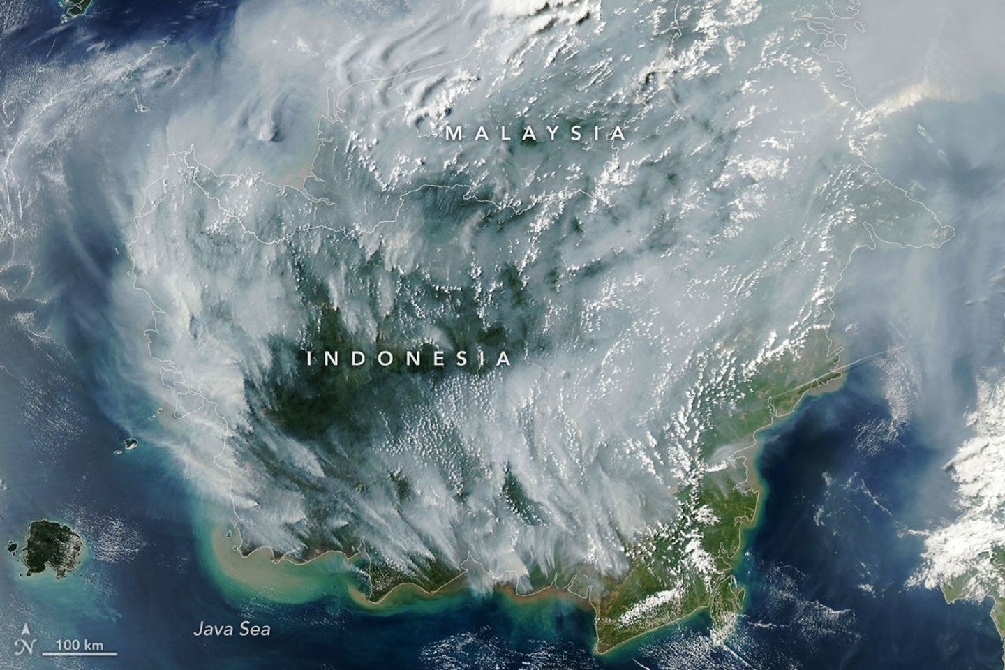
Is there haze in Sarawak or Sabah, and why does Malaysian Borneo get smoke from Kalimantan? Sarawak and Sabah share Borneo with Indonesian Kalimantan, while Brunei is also located on the island. When peatland and vegetation fires burn in Kalimantan and winds carry smoke north or across the border, Malaysian towns may experience elevated fine particles. The impact is not uniform: Kuching, Samarahan, Serian, Sri Aman, Sarikei, Sibu, Bintulu, Miri, Kota Kinabalu, Keningau, Sandakan, Tawau and Labuan can differ. Check the official Department of Environment APIMS API/IPU and the relevant state notices, not a photograph or reading from another city.
How serious has the 2026 Borneo haze been, and what should families check? In August 2026, official reports documented very unhealthy and hazardous readings in parts of Sarawak; on 30 August, the Serian district monitoring station reportedly reached API 364. In September, all six reported Sabah stations were in the Unhealthy band during one dated update. These facts describe specific past hours, not conditions at the time you are reading this page. Families, schools, workplaces, outdoor workers and visitors should use current station data, official public-health advice and the actual activity duration when deciding how to reduce exposure. This guide explains the Borneo geography, distinct regional patterns, peat fires, education, tourism, transport, biodiversity and prevention.
Borneo haze in 60 seconds: the quick guide
- Current Malaysian API: Department of Environment APIMS, choosing the town and observing the latest timestamp.
- Sarawak state context: Natural Resources and Environment Board Sarawak, including its published air-quality information and state announcements.
- Regional source and wind: ASEAN Specialised Meteorological Centre for hotspots and regional haze analyses.
- Fire-prone neighbour: Indonesian Kalimantan, which occupies a large part of Borneo; local fires also need consideration.
- Sarawak towns to distinguish: Kuching, Samarahan, Lundu, Serian, Sri Aman, Sarikei, Sibu, Mukah, Bintulu, Samalaju, Miri, Limbang and others.
- Sabah towns to distinguish: Kota Kinabalu, Kimanis, Keningau, Sandakan and Tawau; Labuan is a separate federal territory.
- Most important safety factor: The measured local category combined with a person’s health, time outdoors and level of exertion.
- For schools: Check latest Education Ministry and institution-specific notices before assuming a closure or sports decision.
- For tourism: National parks, coastal trips, longhouse visits, outdoor walks and flights have different operational and exposure considerations.
- Historical warning: Sarawak’s 1997 severe haze emergency and the 2026 episodes show that the problem can be substantial without applying equally to every Borneo location.
The key sequence is fire region → moving air → local monitored exposure → practical decision. A headline about Borneo is only the beginning.
Malaysia on Borneo: a different geography from the peninsula
Peninsular Malaysia lies next to Sumatra across the Strait of Malacca. East Malaysia lies on Borneo. Sarawak extends across much of the island’s north-west, and Sabah occupies the north. Indonesian Kalimantan spans extensive southern and central parts of Borneo. Brunei sits within northern Borneo’s coastal geography, while the federal territory of Labuan is offshore.
These locations matter because a plume from Kalimantan can cross a land border or pass along coastal air routes into Sarawak and Sabah. It need not travel across the Strait of Malacca to reach Malaysian communities. That is why a smoke map for western Borneo is often more relevant to Kuching than a map focused entirely on eastern Sumatra.
But location alone is not attribution. A fire hotspot in Kalimantan provides evidence of possible active burning. To understand its consequences for Sarawak, investigators still need wind direction, plume information, rain, altitude and ground monitoring. The Malaysia haze geography reference describes these steps across both Malaysian regions.
Why western Sarawak is frequently discussed in haze reporting
Western Sarawak’s towns are relatively close to parts of West Kalimantan. In suitable transport patterns, smoke can move northwards into Malaysian districts. Some fires occur in peat-rich or otherwise disturbed landscapes where dry conditions and ignition allow prolonged smoke production.
On 15 August 2026, Bernama quoted Malaysia’s Department of Environment discussing hundreds of satellite hotspots in Kalimantan and moderate-to-dense smoke moving towards western Sarawak. The same report also noted locally detected Malaysian hotspots, reminding readers that regional and local contributors need to be examined.
Do not read hotspot dots as verified crimes or as exact measurements of the smoke a person inhales. Satellite detection can be limited by cloud, sensor passes, thick smoke and the hidden nature of underground peat burning. Cross-border transport is plausible, but attribution must stay evidence-based.
Kuching and Samarahan: one metropolitan region, several readings
Kuching and neighbouring Samarahan connect through education, employment, housing and daily travel. Yet they are not one air-quality instrument. A university student may spend time on an open campus, travel through traffic and study indoors. A schoolchild may have outdoor PE, while a healthcare worker may spend most of a shift in mechanically managed buildings.
Each routine has different exposure implications. A student doing strenuous outdoor exercise breathes more air per unit time than a person resting indoors. A long open-air commute or fieldwork session may matter even when the formal workday takes place inside.
During haze, schools and households need accurate local API readings and current institutional notices. A photograph of the Kuching skyline can make the issue visible, but it does not replace a dated station reading.
Serian: why 30 August 2026 is a useful case study
On 30 August 2026, Bernama reported that the monitoring station at Serian District Police Headquarters recorded API 364 at 8 am, in Malaysia’s Hazardous category. On the same report, Samarahan was 300, Kuching 291 and Sri Aman 214. These were severe dated conditions, not current values.
The difference between 364 and 291 is 73 index points, but it would be wrong to claim that people in Serian inhaled exactly 73 micrograms more PM2.5 per cubic metre. API is a pollutant-derived public index; it is not raw mass concentration. Its values and categories must be interpreted in the official Malaysian system.
This case illustrates why one state can contain multiple areas of concern at the same time. It also shows how quickly a headline becomes stale. A student citing the record in an essay must write ’30 August 2026, 8 am’, not merely ‘Serian’s current API is 364’.
Sri Aman and Lundu: distinct exposure patterns
Sri Aman appears repeatedly in both Malaysia’s historical haze record and 2026 reporting. A Bernama update dated 28 August 2026 recorded API 211 at Sri Aman at 2 pm, a Very Unhealthy value. Reports from the period also mentioned changing conditions in Lundu, Lubok Antu and Serian.
These local differences reflect a moving environmental problem. Different wind routes, precipitation, plume heights and local emissions may produce variations across a region that looks close together on a national map. It would be misleading to label every village between Kuching and Sri Aman with one station’s number.
For families and administrators, the right tool is a local official measurement and a communication plan. For scientists, the next step is to analyse source regions, meteorology and observational uncertainty.
Sarikei, Sibu, Mukah and Bintulu: riverine and coastal connections
Central Sarawak contains river systems, coastal areas, population centres, agriculture, industry and transport networks. Towns such as Sarikei, Sibu, Mukah and Bintulu are geographically separated. An airborne plume may affect them differently as it travels, while local burning and other emissions can complicate interpretation.
Some livelihoods involve prolonged work outdoors: river transport, agriculture, maintenance and construction are examples. A general ‘stay indoors’ headline is therefore not a complete occupational-safety plan. Employers must follow appropriate Malaysian requirements and plan tasks, rest options, exposure reduction and symptom reporting based on the actual conditions.
For school or family travel between these towns, remember that a road or river journey can span several weather conditions. An air-quality update for Kuching at breakfast cannot be assumed to describe Bintulu late that evening.
Miri, Limbang and northern Sarawak: not the same as Kuching
Sarawak extends a long way from west to north-east. Miri and Limbang lie in a different geographical context from Kuching or Serian, and coastal weather may vary. A regional wind shift can expose western districts more heavily while other areas report less severe conditions—or produce another pattern altogether.
On 28 August 2026, the same Bernama report that listed Sri Aman and Serian also recorded Miri at API 116 and Bintulu at 120, both Unhealthy but far below Sri Aman’s reported 211 at that time. The numbers are not a permanent ranking of towns. They show local variation on one historical day.
Regional comparisons become clearer when every station is plotted with a label and time. A source map alone cannot fill the gaps between those measurements with precise values.
Sabah: the northern half of the Borneo story
Sabah occupies the north of Borneo and includes coastal, urban, highland and inland environments. Kota Kinabalu, Kimanis, Keningau, Sandakan and Tawau are spread around different parts of the state. Pollution transported through the atmosphere may reach them under suitable winds, but the exposure route need not be identical to western Sarawak’s.
This geographical distinction is important in national reporting. A severe API in Serian does not automatically mean Kota Kinabalu, Sandakan or Tawau has the same concentration. Conversely, distance from western Sarawak does not guarantee that Sabah is protected from regional fire smoke.
An accurate description starts with Sabah’s own official monitoring, then examines weather and suspected sources. Avoid copying a Sarawak map caption and presenting it as a direct statement about all of East Malaysia.
What Sabah’s six stations showed in September 2026
Malaysia’s National Disaster Management Agency reported on 3 September 2026 that all six Sabah air-quality monitoring stations had Unhealthy readings at 5 pm on 2 September. Values included Kota Kinabalu 172, Politeknik 178, Kimanis 171, Keningau 174, Sandakan 145 and Tawau 102.
The report described haze believed to be transported from Kalimantan under the regional winds. It also noted that local Malaysian agencies had not identified major fires in several named Sabah districts at that point. Those observations support a possible transboundary mechanism for the date, but they do not establish that every pollutant came from one location or operator.
For teaching, the most interesting value is not merely the highest one. Tawau’s reported 102 and Politeknik’s 178 were both in the same broad Unhealthy category. This demonstrates why a state-wide label conceals local detail.
Kota Kinabalu and coastal everyday life
Kota Kinabalu contains urban homes, offices, schools, transport nodes and waterfront activity. A normal day may involve commuting, outdoor markets, university or school campuses and recreational walks. When a relevant API is elevated, the household needs to consider how long people are exposed and what exertion is involved.
There is no reliable shortcut in saying ‘the sea breeze will clear everything’. Coastal circulations can dilute pollution in some circumstances and transport a plume in others. Rain may help locally, but regional fire emissions can continue. The physical explanation must be checked against observations.
For visitors, destination weather and current air-quality advisories are distinct from an online travel guide. Confirm actual conditions and individual venue announcements before an outdoor programme.
Sandakan and Tawau: eastern Sabah needs individual checks
Sandakan and Tawau are important regional towns with different coastal settings from Kota Kinabalu. The 2 September 2026 reported readings were not identical: Sandakan 145 and Tawau 102. A later day could show a different ordering if wind, rainfall and emissions change.
Longer outdoor work, community activities, sports and school excursions may require adjustment according to the current Malaysian guidance. A traveller spending a day in one town and moving to the other should look up both locations rather than using a single Sabah headline.
A station reports the quality of sampled air at a particular monitoring point over the applicable period. It is informative, but it does not establish the exact concentration in every building, hill or beach.
Labuan, Brunei and the shared maritime environment
Labuan is a Malaysian federal territory, not part of Sabah’s state administration, though it lies near Sabah’s coast. Brunei is a separate sovereign country on Borneo. The distinction matters when checking public agencies, weather information and operational notices. These areas are geographically related but do not share one legal authority or monitoring system.
Air crossing an international border does not automatically change composition. Yet weather and local emissions can still create different observations at nearby locations. For travellers, check the responsible authority in the actual jurisdiction and do not assume a reading for one country or territory is identical to another’s.
Marine and aviation conditions depend on their own visibility, weather and safety procedures. A public API helps explain air quality but does not, by itself, decree that a ferry or flight can operate.

Why peatland fires produce a persistent haze risk
Peat consists of partly decomposed organic material formed in wet environments. When drained and dried, it can burn and smoulder below the surface. These fires may continue even when visible flames disappear, producing smoke over prolonged periods. Their management is more complicated than putting out a small surface vegetation fire.
NASA’s 3 September 2026 Earth Observatory article explains how drought and dry peat allowed extensive burning in Indonesian regions including Borneo. NASA observed smoke from numerous fires on 1 September 2026, and noted that some fires are difficult for satellites to detect through thick smoke, cloud and soil.
This evidence supports the physical mechanism. It does not make a historical image a live map, and it does not independently establish responsibility for any particular person’s land use. The Malaysia peat and haze causes guide explains the fire physics.
The role of the Southwest Monsoon and El Niño
Regional rainfall and prevailing winds help set the conditions in which fires spread and smoke travels. A dry Southwest Monsoon period may make certain fire-prone landscapes more vulnerable, while El Niño can increase drought risk in parts of maritime Southeast Asia. These effects are not deterministic: rain and winds vary, and a climatic pattern is not itself an ignition.
On Borneo, the relevant smoke pathway can be across land from Kalimantan or over adjacent coastal waters. The three-dimensional atmosphere also matters. Winds above the surface may differ from street-level breezes, and a plume can travel aloft before mixing down.
METMalaysia and ASMC provide the appropriate meteorological context. An air-quality station then shows the measured receiving-area index. Both sources are needed to connect a possible fire to people’s exposure.
What satellites can and cannot show about Kalimantan fires
Sensors such as MODIS and VIIRS can detect thermal anomalies associated with active fires. Images can also show regional smoke, while other instruments assess aerosols in the atmospheric column. The data are useful for detecting risk, monitoring patterns and guiding field investigation.
But not every fire appears as a hotspot. Thick cloud, obscuring smoke, small understory fires and peat smouldering below ground can prevent detection. A hotspot is not a legal judgement about land ownership, deliberate ignition or corporate responsibility. Those questions require additional evidence.
A practical student exercise compares one dated NASA image with a matching ASMC wind chart and published ground API. The conclusion should describe what the sources support and what remains uncertain.
The 1997 Sarawak haze emergency: a regional warning
Malaysia’s Department of Environment history records severe haze in Sarawak during the 1997 El Niño period, with API exceeding 500 and a haze emergency declared for 19–28 September 1997. This is one of the most significant historical reminders that East Malaysia can face severe regional pollution.
Historical context helps explain why fire prevention and land-water management are public-health concerns far beyond the fire site. But no one should assume that the 1997 plume, the 2015 fire season and the 2026 events had exactly the same origin, duration or exposure pattern.
A careful comparison looks at fire activity, meteorology, station locations and how indices were calculated at the time. It separates the broader recurring vulnerability from the specific mechanism of each episode.
Schools: decisions in Kuching are not Sabah-wide orders
Malaysian school closures and outdoor activity decisions depend on the latest applicable Ministry of Education and institution-specific notices. The national guidance was clarified during October 2026 after an earlier temporary change. A school announcement in Kuching does not automatically tell parents what a school in Sandakan or Keningau is doing.
Administrators need to identify the relevant official index, document any applicable directive, plan suitable indoor alternatives, protect students with medical conditions and communicate practical transport or learning changes. Individual healthcare plans may matter even when a general closure condition has not been triggered.
The Malaysia haze schools 2026 guide explains the dated policy background and how families can verify the latest instructions. It is not a substitute for a real school’s notice or healthcare professional advice.
Longhouses, rural communities and access to cleaner air
Some communities across Borneo live far from major urban services or have different housing and transport arrangements. A plan that assumes everyone can instantly enter a filtered office building is therefore unrealistic. The ability to avoid smoke depends on building design, access to equipment, household resources, medical services and the need to work outdoors.
Appropriate public-health communication should recognise local languages, trusted community contacts, actual electricity and ventilation arrangements, and the needs of older people and children. Maintaining thermal comfort and adequate indoor ventilation is important; sealing a naturally ventilated house completely may create other hazards.
Equitable planning asks who has the fewest alternatives and how institutions can provide practical support, rather than placing the full responsibility for cross-border pollution on individual households.
Tourism, national parks and rainforest journeys
Sarawak and Sabah are well known for rainforest, wildlife and outdoor destinations, including parks, river systems and coastal experiences. Visitors may plan demanding hikes, longboat trips, wildlife viewing or community stays. These experiences can involve hours of outdoor exposure and sometimes remote locations with limited alternatives.
During elevated air pollution, tourists and operators should assess actual regional conditions, individual health and the nature of the activity. A strenuous walk is different from a short indoor cultural visit. Weather, park restrictions, transport operations and local safety notices should be checked separately rather than inferred from a single API number.
No park, forest or mountain is guaranteed to be smoke-free simply because it contains trees or lies at higher altitude. Air moves at several heights, and rain or fog can alter visibility without providing an exact pollutant concentration.
Aviation, marine travel and regional logistics
Borneo’s geography makes regional aviation, roads, coastal shipping and river transport especially significant in some districts. Severe visibility reduction can create operational challenges, but a public API alone is not an aviation or marine closure instruction. Airlines, airports and marine operators use specific safety and weather criteria.
Visitors should check the current operator rather than assuming that all flights to Kuching or Kota Kinabalu will be disrupted when one district reports Unhealthy API. Likewise, transport between inland communities requires locally relevant information and an understanding of weather and travel time.
The economic effects can extend to businesses dependent on deliveries, outdoor workers and tourism. Planning should distinguish an observed disruption from a hypothetical future risk.
Forests, wildlife, peat and the climate consequences
Borneo’s forests support important biodiversity, including habitat for orangutans in parts of the island. Fire can damage vegetation, peat swamps and wildlife habitat while releasing large amounts of stored carbon from dry organic soils. The worst ecological damage may occur in the landscape that burns, even when smoke reaches distant Malaysian towns.
Contemporary reports during the 2026 Indonesian fire season have described displaced wildlife and pressure on rescue services in Kalimantan. Those accounts illustrate a serious ecological concern, but should not be rewritten as proof that every Sarawak or Sabah forest was burned or that one specific Malaysian population of animals suffered the same fate.
The Malaysia haze prevention and ASEAN reference examines water management, early fire detection, community support and regional cooperation—the measures that address the upstream causes rather than only protecting people after smoke arrives.
Fire prevention must include Malaysia’s own landscapes
Transboundary fire smoke is a major part of the Borneo haze story, but Malaysian authorities also monitor local burning. The August 2026 DOE statement discussed some local hotspots in Sarawak and Sabah alongside many detected in Kalimantan. An accurate response does not dismiss domestic fire prevention because a much larger regional plume may be present.
Hydrology, land use, burning restrictions, community fire patrols and early response matter. Where peat has been drained, suitable restoration can reduce vulnerability, although projects require site-specific engineering and social considerations. Blaming a single industry or person from an undated hotspot map is not adequate evidence.
National and regional efforts should therefore reinforce each other: prevent avoidable ignitions locally, exchange regional fire and wind data, respond promptly and measure whether exposure falls.
Worked example: interpreting Sarawak and Sabah measurements
Dated historical case, not a live comparison: On 30 August 2026, Serian was reported at API 364 while Kuching was at 291. On 2 September, a later Sabah report listed Kota Kinabalu at 172 and Tawau at 102. The numbers come from different dates, so students must not create one same-time ranking across the four stations.
The difference Serian minus Kuching on the same reported date is 364 − 291 = 73 index points. The difference Kota Kinabalu minus Tawau in the Sabah report is 172 − 102 = 70 index points. These subtractions are arithmetically valid, but neither is a physical particle-concentration difference.
A strong student writes the date beside each pair, applies the correct Malaysian API categories and says what additional evidence would be needed to explain a cause. A weak answer simply says the town with the largest number had ‘the most smoke from Kalimantan’ without considering index definitions, transport or local sources.
An example Borneo family itinerary during a haze episode
Imagine a hypothetical trip combining Kuching, an inland excursion and a later flight to Kota Kinabalu. The family checks the latest API and any operator advice for each destination, not just the departure city. A child with asthma follows an existing clinical plan, while a long outdoor trek receives more scrutiny than an essential short indoor visit.
If rain arrives, the family checks whether official readings improve instead of assuming the pollution has ended. The plan includes alternative indoor activities where practical, a transport contact, necessary medicines and flexibility around weather-dependent operations.
The point is not to declare Borneo unsuitable for travel. It is to make decisions using the actual environmental and operational conditions of places people will visit.
How to avoid five common Borneo haze mistakes
Mistake 1: calling Sarawak and Sabah one air-quality district. They occupy different parts of a large island and have several separate monitoring stations.
Mistake 2: treating Kalimantan hotspots as identical to ground exposure. A satellite fire marker and a Malaysian station API answer different questions.
Mistake 3: forgetting local fires. The regional plume may dominate, but domestic sources still deserve evidence-based attention.
Mistake 4: believing rainforest or mountain air is automatically protected. Elevation, tree cover and visibility do not guarantee low PM2.5 during regional smoke transport.
Mistake 5: comparing reports from different hours as if they were simultaneous. Include dates, time zones, stations and measurement methods before calculating a trend.
Correcting those mistakes turns a confusing regional news story into an informed geographical explanation.
Frequently asked questions: haze in Sarawak and Sabah
Does all haze in Sarawak come from Kalimantan?
No. Transboundary transport is important in some major episodes, while local vegetation or peatland fires and other pollution sources can also contribute.
Was Serian’s API 364 in October 2026?
The cited API 364 was reported for 8 am on 30 August 2026, not as a current October reading. Check APIMS for present values.
Was Kota Kinabalu as hazy as Kuching in 2026?
Their readings varied by date. Comparisons must use simultaneous official measurements and recognise the different monitoring locations.
Did all of Sabah record Unhealthy API in September?
The reported six Sabah stations all showed Unhealthy readings at 5 pm on 2 September 2026. That is a historical snapshot, not a permanent condition.
Is Labuan part of Sabah’s official air-quality count?
Labuan is a federal territory. It should be checked as its own administrative and monitoring location rather than automatically grouped as a Sabah station.
Are national parks safer than city streets during haze?
Not automatically. Trees and elevation cannot guarantee a low particle concentration. Review the local API, park notices and planned exertion.
Does an old satellite image prove a particular plantation caused the fire?
No. Thermal detections and smoke observations cannot by themselves establish legal responsibility. Verification and additional evidence are needed.
Can students attend outdoor sports when an API is Unhealthy?
Follow the latest Malaysian education or organiser instructions, individual healthcare needs and official health guidance. An article cannot authorise a specific school event.
Which is more important, a satellite smoke map or APIMS?
They are complementary. Satellite and ASMC products help explain likely source and transport; official Malaysian APIMS reports local monitored air quality.
Continue through eduKate’s haze library and wider Borneo ecosystem
- How Haze Works | SEA 2026 master hub — regional science and response.
- Malaysia haze geography — Sumatra and Kalimantan smoke routes.
- Malaysia haze causes — peat fires, monsoon and climate.
- Malaysia API and PM2.5 — index and station interpretation.
- Malaysia haze effects — health, schools, workplaces and tourism.
- Malaysia haze history — Sarawak’s 1997 emergency and recent episodes.
- Malaysia home air and HEPA guide — household exposure reduction.
- Malaysia haze schools 2026 — dated education rules and family plans.
- Malaysia prevention and ASEAN strategies — upstream fire management.
- Kuala Lumpur and Selangor haze — comparison with the peninsula.
- Johor Bahru and Melaka haze — southern cross-border smoke.
- Penang and northern Malaysia haze — northern monsoon routes.
- Civilisation Atlas | Borneo and Brunei — the island’s human and environmental geography.
- eduKate tourism guide to Malaysia — destination background.
Official sources and scientific references
- Malaysia Department of Environment: APIMS
- Sarawak Natural Resources and Environment Board
- Bernama 30 August 2026: Serian hazardous API 364
- Bernama 28 August 2026: Sri Aman and Sarawak stations
- Malaysia NADMA: Sabah’s six monitored stations, 2 September 2026
- Bernama 15 August 2026: Kalimantan and Malaysian hotspots
- NASA Earth Observatory: Peatland Fires Darken Skies in Indonesia, September 2026
- ASEAN Specialised Meteorological Centre: regional smoke and wind analysis
- Department of Environment: history of the 1997 Sarawak emergency
- World Health Organization: air pollution and health
Editorial checkpoint: 17 October 2026. All August and September API examples are historical, not today’s readings. The featured NASA Aqua image was recorded on 1 September 2026; it illustrates regional fires, not a current surface API for a particular Malaysian town.