
Is there haze in Penang, Kedah, Perlis or Perak, and where do you check the air? Northern Peninsular Malaysia does not have a single haze reading. George Town, Minden, Balik Pulau, Seberang Jaya, Seberang Perai, Langkawi, Alor Setar, Sungai Petani, Kulim, Kangar, Taiping, Ipoh and Seri Manjung can show different conditions. Use Malaysia’s official APIMS Air Pollutant Index (API/IPU), selecting the relevant station and checking its timestamp. The API describes monitored air quality, not just whether an island skyline looks clear or a mountain viewpoint looks misty.
Why can northern Malaysia become hazy when the fires are far away? Fine-particle smoke from Sumatra and other regional fires may travel over substantial distances as winds shift. Northern districts can also experience local emissions and vegetation fires. Coastal breezes, hills, rainfall and the height of the smoke plume can make conditions uneven between Penang Island and the mainland, between the northern states and Perak, or between Langkawi and inland Kedah. This guide explains the geography, monitoring, 2026 examples, historic haze migration, food and tourism, school life, health and exercise in northern Malaysia.
Northern Malaysia haze: quick answers first
- Live source: APIMS official Malaysia API. Read the station and time before sharing.
- Penang stations: Minden, Balik Pulau, Seberang Jaya and Seberang Perai are identified by Penang’s Department of Environment reporting.
- Kedah: Check local readings including Alor Setar, Sungai Petani, Kulim or Langkawi where available.
- Perlis: Use local monitoring near Kangar when relevant.
- Perak: Ipoh-area stations, Taiping, Tanjung Malim and Seri Manjung may provide distinct information for different destinations.
- Potential source route: Transboundary smoke transported across the Strait of Malacca or mainland, modified by local winds and rain.
- For health: Risk depends on air quality, outdoor exposure time, physical effort and personal medical circumstances.
- For tourists: Hiking Penang Hill, walking George Town or spending a beach day in Langkawi are different exposure situations.
- For schools: Follow the latest applicable Malaysia Education Ministry and school instructions.
- For interpretation: A misty mountain view is not a substitute for actual PM2.5 or official API measurements.
A clear haze plan names a specific place, a specific reading time and a specific activity. ‘Penang is smoky’ is a headline; ‘Minden station reports this API category at this hour’ is useful evidence.
Why northern Peninsular Malaysia’s map matters
Penang has an island and a mainland area, connected by major bridges and transport routes. Kedah extends through coastal areas, mainland towns, islands including Langkawi, agricultural landscapes and interior hills. Perlis is near the Thai border. Perak stretches from coastal and lowland districts to valleys and uplands. These differences influence people’s routines and their local weather.
A large smoke plume may pass over multiple states, but its concentration is not necessarily identical everywhere. Local showers can remove particles in one district while a neighbouring area remains polluted. Some smoke travels above the ground and may mix down later. Coastal breezes can influence near-shore transport, and roads or industrial activity contribute local pollution.
It would be a mistake to claim that Penang is always the most affected just because it is a west-coast destination, or that Perlis is automatically protected by being farther north. Each event needs actual current air-quality evidence and wind context.
Penang Island versus Seberang Perai: one state, several environments
Penang’s island contains George Town, Minden, Balik Pulau, coastal districts and upland terrain. Across the strait, the mainland includes Seberang Jaya and Seberang Perai, with residential, agricultural and industrial areas. The island–mainland distinction matters for local microclimate, daily journeys and available monitoring stations.
According to Bernama reporting on 13 August 2026, Penang’s Department of Environment had four automatic air-quality monitoring stations: Seberang Jaya, Seberang Perai, Minden and Balik Pulau. At Minden that day, the API reportedly decreased from 107 at noon to 103 an hour later and 97 by 3 pm. It crossed from Unhealthy to Moderate as the reported value changed.
The example shows why a station’s hourly update and averaging methodology matter. It does not mean every classroom or beach nearby had those exact concentrations. Nor does it prove all of Penang improved at precisely the same moment. Real air-quality data should always be tied to a place and timestamp.
George Town heritage walks and street-food outings
George Town’s cultural and historic setting makes walking, sightseeing and food exploration part of a visitor’s experience. During an elevated API period, an outdoor heritage tour lasting several hours may create more exposure than a shorter visit to a suitably managed indoor venue. Planning should account for the duration, intensity, personal health and outdoor conditions rather than treating all tourism as either safe or forbidden.
Open-air food courts, shophouse corridors and sheltered markets are not sealed environments. Even with a roof, outdoor smoke may move through. Indoor galleries, museums and cafés also vary in filtration and ventilation; check actual venue conditions. A tourist who is vulnerable to smoke should not assume any particular attraction can provide medical protection.
Rain can improve conditions locally, but a single passing shower does not establish that the rest of the day’s air will remain clear. Refresh official data before a long outdoor walk instead of trusting the colour of the horizon.
Minden, Balik Pulau and why exact station choice matters
Minden and Balik Pulau are both on Penang Island, but they do not share identical surrounding land use and terrain. The same applies when comparing a mainland industrial area with a coastal or hilly location. An observation from one station provides useful information without measuring every other neighbourhood directly.
The difference becomes important for families who attend school in one place, live in another and spend weekends somewhere else. A single check at breakfast can be insufficient for an afternoon outing after the wind changes. Use an updated station relevant to the planned activity and clearly say when a reading belongs to another locality.
A school or organiser should also distinguish between a station’s published index and an instantaneous indoor sensor value. These answer different questions and must not be substituted without explanation.
Penang Hill: altitude is not a guarantee of clean air
Penang Hill Corporation highlights its panoramic views and nature attractions. People often hope that a higher location will rise above visible haze, and at times layers of smoke may indeed sit at different altitudes. But the vertical structure of the atmosphere changes. Some plumes travel at elevation and later mix down, so a hilltop cannot be advertised as a permanent clean-air refuge.
Hiking uphill also raises breathing rates and may take considerable time. That matters during elevated pollution, especially for people with respiratory or cardiovascular concerns. Consider the official data, personal health, weather, trail access and current park guidance before a strenuous hike.
A foggy or misty view is not automatically biomass-burning smoke. Humidity, clouds and water droplets influence visibility. Similarly, a pleasant clear view does not guarantee the air contains no fine particles. Measure rather than guess.
The Penang Hill and Botanic Gardens distinction
Penang’s Botanic Gardens and hill trails offer different kinds of outdoor recreation. Their microclimate can vary with rain, shade, slope and elevation, but none of those features alone supplies a pollutant concentration. If the API is elevated, reconsider prolonged exercise and any planned fieldwork according to health and official guidance.
Families sometimes assume a rainforest trail must cancel the effect of imported smoke because trees provide ecological benefits. Forests are important for shade, habitat and long-term environmental processes, but a nearby stand of trees cannot be treated as an air-filtering guarantee for a person breathing during a regional smoke plume.
For tourism and education, this is a powerful distinction: ecosystem services are real, yet public-health choices require local exposure information. See the Penang Hill official attractions page for venue information, and confirm actual access conditions before travelling.
Langkawi: island travel needs its own API check
Langkawi is geographically separate from mainland Kedah and has substantial outdoor tourism activity, including beaches, viewpoints and boat-based experiences. An index observed in Alor Setar or Sungai Petani should not be treated as the actual reading at Langkawi. Winds, rainfall and local air masses may differ during the same period.
A Bernama update on 29 August 2026 recorded Langkawi at API 157, Alor Setar at 155 and Sungai Petani at 161 among its dated northern observations. All were in the Unhealthy category that morning, but the figures should never be reused as today’s island forecast.
A beach visitor’s main questions are practical: How long will we be outdoors? Are we swimming, hiking, boating or merely transferring between venues? What does the relevant official index show now? Are there current operator or marine notices? Personal health and time outdoors matter more than the idea that islands always have ‘fresh sea air’.
Kedah’s towns, farms and schools
Kedah is both an urban and agricultural state. Outdoor work, school transport, farming operations and town markets may all be affected when smoke reaches the area. A farmer performing a long physically demanding task faces different exposure from a student spending most of a day in a suitably managed classroom.
Some smoke may arrive through regional transport, while local fires and emissions can also affect the air. An elevated station reading cannot automatically assign a single cause. To attribute an episode, compare likely fire regions, wind charts, local observations and pollutant information.
For schools in Alor Setar or Sungai Petani, the right action is to follow current local official measurements and applicable Malaysian Education Ministry and school procedures. The Malaysia 2026 school haze guide explains why the dates of October notices matter.
Perlis and Kangar: north does not mean immune
Perlis occupies the northern end of the peninsula, close to the Thai border. It is farther from some well-known Sumatran source areas than southern west-coast districts, but that distance does not make it immune to transported pollution. Winds at different heights can carry particles across long regional paths.
Bernama’s 29 August 2026 report recorded Kangar at API 155, an Unhealthy reading on that historical morning. The important lesson is not that Kangar is always polluted. It is that northern position alone is an unreliable guarantee.
For residents, the decision remains local. Read the current station value and the Malaysian health advice. For students, ask what evidence is needed to show that smoke from a particular source region reached Perlis rather than assuming a route from the map alone.
Perak: Taiping, Ipoh and Seri Manjung need separate readings
Perak spans coastal districts, hills, valleys and inland cities. Taiping, Ipoh, Tanjung Malim and Seri Manjung occupy different settings, making a single state-wide haze claim too broad for personal planning. A long road trip may pass through districts with different air quality and weather during the same day.
On 25 August 2026, a Bernama report listed Tanjung Malim 157, Taiping 155, Tasek Ipoh 155, Pegoh Ipoh 153 and Seri Manjung 152. Those readings were all Unhealthy at the reported time, but they cannot be converted directly into identical PM2.5 concentrations or exposure doses.
Nearby hills and valleys can affect local ventilation, but do not treat terrain as a sealed container that explains every reading. Weather, regional smoke and local emissions interact. A rigorous report states what the instruments measured and what remains a hypothesis.

Why wind changes can shift the haze north
The 2005 Malaysia haze chronology and contemporary August 2005 reporting describe a period when haze over the Klang Valley improved while smoke shifted towards northern states, including Perak, Penang, Kedah and Perlis.
This historical event offers a simple geography lesson. A polluted air mass can move rather than vanish. Rain and stronger ventilation may help one place, while winds deliver some material to another. A headline about improvement in Kuala Lumpur does not provide a regional all-clear for Penang.
The actual plume pathway in a new year requires new observations. A historical illustration shows that transport is possible, not that the wind in October 2026 necessarily follows the route seen in August 2005.
Monsoons, rain and the difference between weather and air quality
METMalaysia describes broad monsoon and inter-monsoon patterns across the region. Southwest Monsoon periods can be relatively dry over much of the country, while rain and wind vary by location and time. Dry spells can increase regional fire risk; the wind then determines where emitted smoke travels.
But weather and air quality are separate measurements. A brief downpour may improve local visibility and remove some particles, yet continuing fires can supply new pollutants. High humidity may make an existing aerosol plume scatter more light. A cool morning does not prove the index is low.
Readers should use weather forecasts to understand likely changes and official API records to describe measured air quality. Combining both is stronger than inferring concentration from a view of Penang Hill or a photo taken through a car window.
Penang’s 2026 daily variation: a practical observation
On 7 September 2026, Bernama quoted Penang officials reporting that intermittent rain had helped keep much of the state in Good or Moderate air-quality ranges, while Minden recorded a rise into the Unhealthy category during the afternoon. The report distinguished Minden from the other three Penang monitoring stations.
This illustrates two important ideas. First, a state can improve while one local station shows a different pattern. Second, the dominant pollutant in a given monitoring period may not always be the same as another date’s smoke episode. The index should be read with its measurement context.
A household can learn more from repeated dated observations than from a single extreme headline. Record location, time and category, then investigate whether new rain, winds or fire activity help explain the changes.
Tourism: George Town, Penang Hill and Batu Ferringhi
Northern Malaysia’s attractions include heritage districts, beaches, rainforest trails and hill landscapes. Visitors often book multiple outdoor experiences close together. Haze can affect the appeal and suitability of prolonged outdoor activity, but it does not automatically mean every museum, restaurant or hotel has stopped operating.
A useful itinerary divides activities into high outdoor exposure, short outdoor transitions and indoor time, while acknowledging that indoor spaces vary. A strenuous coastal hike differs from an indoor gallery visit. A long open-air food tour differs from a brief transfer between buildings.
Tour operators should communicate current conditions and any changes clearly. A visitor should check the destination’s actual official air quality and relevant venue policies, not just a generic ‘Malaysia haze’ headline from another state.
School children and outdoor learning
Schools in Penang, Kedah, Perlis and Perak may need to review assemblies, PE, excursions and external sports when local air pollution is elevated. Closure and activity decisions depend on the latest applicable Ministry of Education and institutional rules. Because Malaysia’s haze-related school guidance changed during October 2026, it is especially important to verify the date of a notice.
The aim is not to lose learning unnecessarily. A nature-fieldwork lesson can shift to analysing local weather, historical maps and API datasets. Science students can distinguish PM2.5 concentration from an index. Geography students can trace source regions and winds without spending a prolonged period outdoors during poor conditions.
Individual children with relevant health conditions may need additional care arrangements. Schools should coordinate with parents and appropriate healthcare advice rather than relying solely on a single school-wide category.
Exercise, cycling and hill trails
Outdoor walking, running and cycling are valuable routines, but breathing rates rise with exertion. A half-hour gentle walk, a long climb and an intense interval session have different exposure implications. When official advice calls for reducing outdoor activity, intensity and duration are sensible variables to reconsider.
Do not assume that tree shade or elevation automatically removes airborne smoke particles. If an indoor alternative is chosen, ensure it is comfortable and appropriately managed, not a crowded overheated room without adequate ventilation. Activities should remain suited to the person’s health.
People with diagnosed heart or lung conditions should follow professional advice and prescribed care plans. If serious symptoms arise, seek urgent help rather than relying on an app’s map colour.
Agriculture, coastal livelihoods and the northern economy
Northern Malaysia has farming, fisheries, manufacturing, tourism and urban service sectors. Haze-related disruption can affect outdoor labour, visitors, delivery routes and household spending. The specific economic effects depend on severity and what activities are exposed; one API report cannot establish a national loss figure.
Workers outdoors for long periods may have less flexibility than office employees. Employers should apply Malaysian safety and health requirements, review strenuous tasks and provide clear reporting channels for symptoms. A workplace plan may need rest spaces, scheduling adjustments and appropriate respiratory protection procedures when required.
For farmers and fishers, a forecast and a pollution index answer different questions. Weather and sea conditions influence operations, while air quality informs exposure precautions. Both should be considered without collapsing them into one simplistic risk score.
Family homes, air conditioning and smoke entry
Fine particles can infiltrate indoor environments through open windows, doors, vents and small gaps. A split air conditioner primarily cools; its usual dust filter is not automatically equivalent to high-efficiency particle filtration. A properly sized air cleaner may help reduce indoor particles where appropriate, but it needs maintenance and adequate air delivery.
A family should avoid unnecessary indoor pollution from smoke and consider the temperature and ventilation needs of rooms. Do not create an overheated sealed space. Older relatives, babies and people with respiratory conditions may require extra attention under current Malaysian public-health guidance.
The eduKate Malaysia home haze guide explains HEPA, CADR, room sizing, filters, vehicle recirculation and common misleading claims. It is a practical supplement to official information, not a medical diagnosis.
A worked comparison: northern stations in August 2026
Historical classroom data, 29 August 2026: Sungai Petani 161, Langkawi 157, Alor Setar 155, Minden 160, Seberang Perai 157, Seberang Jaya 156, Taiping 155, Kangar 155. These values appeared in Bernama’s report for that day. All were in the Unhealthy range at the reported time.
A student can calculate that Sungai Petani’s index exceeded Kangar’s by 161 − 155 = 6 points. But that does not mean the student can calculate a 6 µg/m³ concentration difference or conclude that one area’s fire exposure was exactly 3.9% higher. The API is an index whose pollutant-specific conversion and averaging must be understood.
For a stronger answer, label the cities on a map, note the dates and update times, compare any rainfall or wind data and state what cannot be inferred. A difference is a measurement observation; its cause needs investigation.
A family road trip from Ipoh to Penang to Langkawi
Imagine a hypothetical travel plan, with an overnight stop in Ipoh, a day in George Town and a later ferry or air journey to Langkawi. The family checks actual current API readings for each area rather than assuming all three destinations share a single northern-state condition.
If poor air coincides with strenuous sightseeing, they review health advice and consider moving some experiences indoors. They check operators for transport and venue conditions, particularly when visibility or weather could affect a journey. They do not assume that a hotel with air conditioning provides medical-grade filtration.
The itinerary demonstrates a broader rule: a changing trip needs changing information. A reading collected at the start of the journey cannot safely be treated as the final destination’s measurement two days later.
FAQ: haze in Penang and northern Malaysia
Does Penang Island have the same air quality as Seberang Perai?
Not necessarily. Penang has multiple official monitoring stations, and readings can differ by location and time.
Is Penang Hill above the haze?
Sometimes smoke layers may differ with height, but no hilltop is guaranteed to be free from fine particles. Check relevant monitoring, weather and activity guidance.
Does Langkawi have clean air because it is an island?
No. Islands can be exposed to transported smoke. Look up the local API instead of assuming sea air is always pollution-free.
Can haze reach Kangar in Perlis?
Yes. Dated 2026 readings show that northern location does not guarantee clean air; the actual plume route varies.
Are Taiping and Ipoh readings interchangeable?
No. They are different locations with potentially different weather and local sources. Use the station relevant to your destination.
Will rain immediately remove haze from all of Penang?
A local shower may help, but it does not guarantee sustained improvement across the island or mainland. Check subsequent observations.
How should a tourist compare a Penang API and a home PM2.5 reading?
They describe different quantities. API is Malaysia’s official index; PM2.5 concentration is a pollutant mass measurement. Read the units and methods.
Do northern schools follow an automatic rule from an old WhatsApp picture?
Do not rely on undated messages. Follow the latest Malaysian Education Ministry and individual school instructions.
Where does northern haze usually originate?
Some episodes involve transported smoke from regional fires, including Sumatra, while local pollution may add to it. Source attribution needs current wind, smoke and fire evidence.
Continue through eduKate’s Malaysia haze library
- How Haze Works | SEA 2026 master guide — the regional explanation.
- Malaysia haze geography — wind pathways across Malaysia.
- Malaysia haze causes and peatlands — why smoke forms.
- Malaysia API and PM2.5 — how the index is measured.
- Malaysia haze impacts — schools, health and the economy.
- Malaysia haze history, 1997–2026 — including the 2005 northward shift.
- Malaysia home air guide — filtration and everyday protection.
- Malaysia haze school guidance 2026 — institutional response.
- Malaysia haze prevention and ASEAN strategy — upstream solutions.
- Kuala Lumpur and Selangor haze — Klang Valley comparison.
- Johor Bahru and Melaka haze — southern peninsula.
- Sarawak and Sabah haze — East Malaysia.
- eduKate’s Malaysia tourism reading — travel context.
Sources and editorial note
- Malaysia DOE APIMS official monitoring
- Bernama 13 August 2026: four Penang monitoring stations
- Bernama 25 August 2026: Perak and Penang monitoring
- Bernama 29 August 2026: Kedah, Penang, Perak and Perlis readings
- Bernama 7 September 2026: Penang showers and local variation
- Malaysia DOE haze chronology
- METMalaysia monsoon and weather
- Penang Hill Corporation official visitor information
- ASEAN Specialised Meteorological Centre
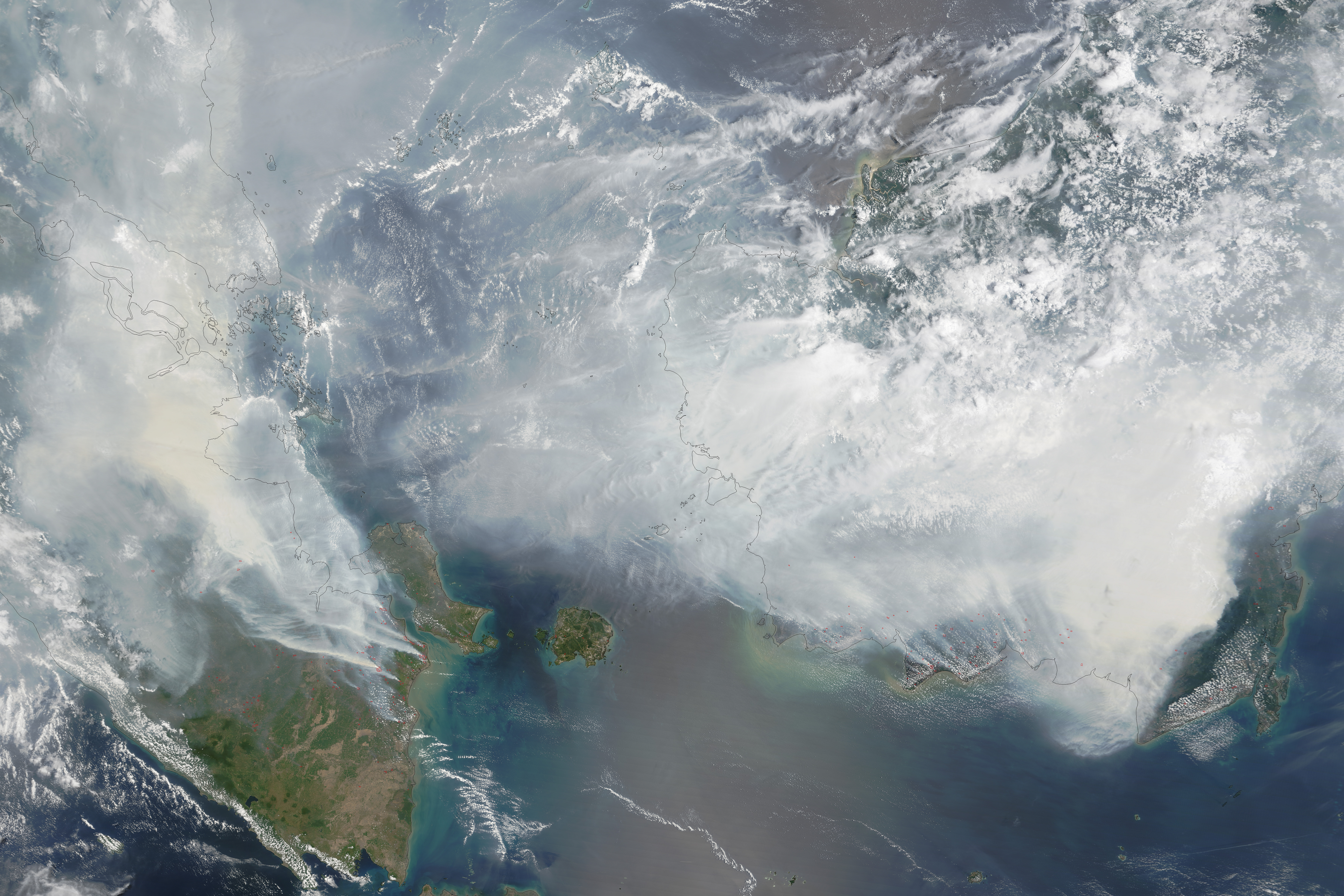
Editorial checkpoint: 17 October 2026. The August and September readings are dated historical examples; the featured NASA smoke photograph is a historical 2015 observation, not a live haze map for northern Malaysia. Check the official APIMS at the actual location before travelling or exercising.