
eduKate • City Hall, Singapore • Secondary 1 Geography • Maps, open space, real sources and independent understanding
Choose your reading route
Start with the child’s actual source-reading difficulty, not an assumption that recognising City Hall landmarks means understanding Geography. Weekday support may help while schoolwork is fresh; a weekend may be better when the student needs recovery. The useful class produces an independent answer later.
Learning need · Worked grid · Scale · Weekday or weekend · Parent questions

Contents
Fourteen practical sections — open the one that helps today
1. The first Geography skill is reading a source without inventing the answer
2. City Hall is a station, a subzone and a historic building name—not one identical shape
3. Read an actual Padang photograph carefully—and resist unsupported visitor claims
4. An original City Hall grid task: compass directions and map legends
5. A worked map scale that does not pretend straight-line distance is walking distance
6. The Civic District mixes civic, cultural, hotel and commercial land uses
7. What makes the Padang more than an ordinary green symbol on a map?
8. Fictional frontage density: why eight landmarks need not be denser than five
9. Weekday or weekend Geography tuition: select the time that supports recall
10. First Principles and the Fencing Method for a child’s first Geography explanation
11. A useful ninety-minute tutorial should make each learner’s thinking visible
12. Four-week map-reading reset: less guessing, more independent accuracy
13. Parent checklist, frequent questions and City Hall Geography reading routes
The first Geography skill is reading a source without inventing the answer
Secondary 1 Geography tuition in City Hall should begin with your child’s first repeated difficulty, not with a list of landmarks to memorise. City Hall MRT, the Padang and the National Gallery make this part of Singapore easy to recognise. But recognition is only a starting point. Geography asks what a map, photograph or diagram actually shows, how features are arranged and what additional evidence would be needed before a broad claim can be made.
Imagine a learner who writes, “The National Gallery is the most visited place in the district because it looks large.” That sentence contains several problems: apparent size in a photograph is not a visitor count, the district boundary has not been defined, and nothing demonstrates that one institution has more visitors than all others. A helpful tutor does not simply tell the child to write “more detail”. The teacher shows how to distinguish observation, comparison, explanation and speculation.
Ask for one piece of recent schoolwork, preferably with comments. If the learner missed a north arrow, focus on orientation. If they cannot calculate a ratio scale, rebuild that conversion. If they can identify a land use but cannot describe a pattern, practise language such as concentrated, dispersed, adjacent and within. If their answer claims too much, ask what the source does not contain. Each weakness deserves a different short exercise.
The MOE lower-secondary Geography syllabus gives a framework for geographical concepts, skills and inquiry. Actual schools may arrange Humanities units differently, so the immediate teaching plan should follow the child’s current topic and assessment. It is not necessary to teach an advanced examination-year case study before a Secondary 1 student can read a legend accurately.
A good first tutorial ends with an unseen question. The learner should work through a new map alone, explain one pattern and acknowledge one evidence limitation. It is a more trustworthy sign of progress than copying the tutor’s polished paragraph into a notebook.
City Hall is a station, a subzone and a historic building name—not one identical shape
Place names can be deceptive because one name may be used for several things. City Hall MRT station refers to a transport node; the historic City Hall building now forms part of National Gallery Singapore; and City Hall is also a named Downtown Core subzone. These are related but not identical spatial objects. An excellent Geography response identifies which one a source addresses before describing a feature.
URA’s Downtown Core guidelines place the City Hall subzone within the Civic District. URA lists civic and community institutions, including National Gallery Singapore and Victoria Theatre and Concert Hall, along with commercial and hotel uses in the wider subzone. That is a planning description of a mixed-use place, not a claim that every building functions as a museum or that all areas share identical opening hours.
Try teaching with three symbol types on a fictional diagram. A small circle marks a station entrance; a rectangle identifies a building footprint; and a shaded polygon represents a larger subzone. The child should explain why the circle cannot substitute for the polygon. The station is a point in the simplified map, while the subzone contains many features. A point observed within a district does not describe everything inside the district.
This matters for everyday questions too. A parent might ask whether a student could walk from the station to a proposed class. A simplified city-centre map may show the general relationship, but the actual route depends on building entrances, safe crossings, vertical connections and the confirmed tuition location. A geographical diagram is not a promise of a certain walking time.
Once a child grasps the difference between a point, line and area, the same skill transfers to river catchments, neighbourhoods, protected land, MRT lines and sampling sites. Simple classification often prevents surprisingly elaborate mistakes later.
Read an actual Padang photograph carefully—and resist unsupported visitor claims
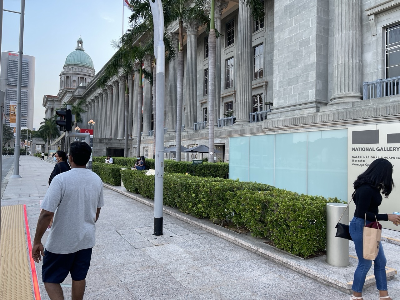
The photograph above shows National Gallery Singapore beside the Padang, with visitors and part of the city skyline visible. Its value is not that it answers every question about the City Hall area. It offers a visual source from which a student can identify buildings, open space and certain human activities at the photographed moment. It does not measure weekly recreation numbers, current cultural spending or every person’s reason for visiting.
Ask the child to write one observation and one explanation. “An open green field is visible next to a prominent civic building” is an observation. “Open space can provide room for recreation and public events” is a plausible geographical explanation. The child must not automatically add “therefore everybody prefers this area” or “the field was empty most days”. Those claims require different evidence over time.
National Heritage Board records that the Padang was gazetted as Singapore’s 75th National Monument on 9 August 2022, becoming the first green open space on the country’s National Monuments list. That source-backed designation is different from what can be read off the photograph alone. It helps students compare evidence types: a photo shows a scene, while an official heritage record documents a legal status and a date.
A practical teaching game uses four claim cards: “There is a field in the picture”; “The Padang is a National Monument”; “It receives exactly 10,000 visitors every day”; and “Some visitors are visible in this image.” The first and fourth can be grounded in the photo. The second needs the NHB record. The third is unsupported by either. Require your child to explain where they would obtain reliable data before including such a number.
This gentle discipline turns familiar photographs into training for interpreting satellite images, maps and data sources used later in Geography. It also teaches an important life habit: knowing when something is observable and when it has only been assumed.
An original City Hall grid task: compass directions and map legends
Here is an entirely fictional classroom map; the grid does not represent real City Hall street coordinates, current entrances or walking routes. Columns A to E run west to east, and rows 1 to 5 run north to south. A school symbol sits at B3, a gallery symbol at D3, and a green-space symbol at B1. A north arrow points towards row 1. Students must answer using this stated system rather than their memory of the real Civic District.
| Fictional feature | Grid reference | Direction from B3 school |
|---|---|---|
| School | B3 | Starting reference |
| Gallery | D3 | Two columns east |
| Green space | B1 | Two rows north |
| Unknown station entrance | Not drawn | Cannot determine its location |
A learner might say that the imaginary gallery lies east of the school because the columns move towards the right while the north arrow points upwards. That answer is correct under the stated rules. But a learner who says “the gallery is a five-minute walk” has invented both route and travel speed. The grid contains no scale, pedestrian crossings or station information.
Now rotate the north arrow so that the right edge of the paper becomes north. The apparent rightward direction on the page is no longer east. The tutor should ask each child to orient the arrow before identifying the new relationship. A student who repeats “east” from the original answer has memorised the visual arrangement rather than understood direction.
Add a legend with a filled circle for stations, an outlined square for schools and a triangle for museums. Keep all symbols the same colour. A student who identifies the right feature must use its shape and legend, not a colour guess. Move the symbols onto a new diagram and ask for two full sentences. This transfer test helps distinguish fluency from familiarity.
Parents can support this with a quick drawing on paper. Keep the exercise short enough to be enjoyable. The objective is that your child automatically checks orientation, symbols and units before making a statement—not that they memorise an invented City Hall map as a real navigation resource.
A worked map scale that does not pretend straight-line distance is walking distance
Imagine an illustrative map drawn at 1:5,000. One centimetre on paper represents 5,000 centimetres on the ground, equivalent to 50 metres. If two fictional features are 3.4 centimetres apart, the represented straight-line distance is 3.4 × 5,000 = 17,000 centimetres, or 170 metres. A correct answer should show both the calculation and the unit conversion.
| Illustrative measurement | Calculation | Defensible conclusion |
|---|---|---|
| 3.4 cm at 1:5,000 | 3.4 × 5,000 ÷ 100 | 170 m straight-line distance |
| 2.8 cm at 1:5,000 | 2.8 × 5,000 ÷ 100 | 140 m straight-line distance |
| Difference | 170 − 140 | 30 m difference in straight-line separation |
| Actual walk time | No route or speed given | Cannot be determined |
The two main mistakes are worth separating. Reporting 17,000 metres is a unit-conversion error. Announcing that the trip takes exactly three minutes is an evidence error: the drawing supplies neither an actual pedestrian route nor travel speed. It may also omit crossings and the accessible entrance to the destination. A lesson that fixes only arithmetic leaves the geographical interpretation weakness untouched.
Ask for a new problem with a scale of 1:2,000 and a paper distance of 4.5 centimetres. The calculation is 4.5 × 2,000 ÷ 100 = 90 metres. The learner then writes, “This represents straight-line ground distance on the fictitious map; actual route length could differ.” That qualification shows the skill has begun to transfer.
City Hall is a natural context for discussing movement among civic buildings, transport connections and open spaces, but the numbers above are intentionally imaginary. They should never be published as measured distances between actual landmarks. To navigate, a family should consult a current route map or confirmed lesson address.
A parent can ask just two questions after the calculation: “What unit did you start with?” and “What does the answer not tell you?” Those prompts encourage independent verification instead of rewarding quick guessing.
The Civic District mixes civic, cultural, hotel and commercial land uses
A student may imagine City Hall as only a place of monuments. URA’s official Downtown Core description is more varied. The City Hall subzone includes important civic and community institutional uses as well as commercial and hotel functions. This makes it useful for teaching what land use means: the function of a building or space, not merely its appearance or the name of a nearby MRT station.
The former City Hall and Supreme Court buildings now accommodate National Gallery Singapore, an art museum. Their earlier functions differed. A building’s stone facade can remain recognisable while the activities inside change. This distinction will become especially important in Secondary 2 and upper-secondary Geography, but Secondary 1 pupils can first learn to classify a source correctly.
Give students a fictional map with four colour categories: civic and cultural, commercial, hotel and green open space. Ask them to sort drawn icons using a legend. If two icons share the same street but represent different categories, the child should not merge them. A mixed-use area is not a contradiction. It is a pattern of multiple activities occupying nearby sites.
The next question is spatial: why might activities cluster near transport connections or significant public spaces? Accessibility could be a plausible influence, but a map alone does not reveal each organisation’s precise location decision. Historical plans, costs, planning restrictions and community uses can also matter. Teach “may contribute to” before a student becomes accustomed to claiming a single cause.
A useful first-year response might say, “The fictional map shows cultural institutions and commercial sites in the same sampled area. This suggests a mixture of land uses, but does not show which attracts more users.” It is clearer and more honest than claiming that all buildings in City Hall serve tourists.
What makes the Padang more than an ordinary green symbol on a map?
The Padang is a useful geographical feature because it is simultaneously an open space with recreation functions and a place with documented national significance. NHB’s 2022 announcement records that it became the first green open space gazetted as a National Monument. The designation adds a historical and regulatory dimension that cannot be inferred from the colour green on a city map.
A student using an ordinary land-cover map may correctly identify the Padang as open green space. Another source, such as a national monument register, is needed to identify its protected status. An event photograph might show recreation or a gathering at a particular time. These are different categories of evidence, and the child should learn to combine them without pretending a single map provides everything.
A fictional lesson can ask learners to classify three green areas: an ordinary school lawn, a public open field and a protected heritage landscape. Colour alone does not differentiate the legal status. A legend and an official classification source are necessary. The teacher might then ask what the spaces have in common: all may provide vegetated or open surfaces, yet their allowed uses and history can differ.
A weak answer might claim that every green space in Singapore is a National Monument. The correction is simple: the Padang’s 2022 designation applies to a named site, not a whole land-cover category. Likewise, an event held on a field does not prove that all people in the surrounding subzone attended it.
This lesson gives young learners an early vocabulary for the relationship between place, function, landscape and identity. It also models respectful treatment of public heritage without turning Geography into a list of historical dates.
Fictional frontage density: why eight landmarks need not be denser than five
This is a fully invented teaching dataset, not a count of real cultural venues around the Padang. Three fictional road segments are different lengths, and small building icons mark a particular land-use category. The child must compare icons per 100 metres of road rather than raw counts.
| Imaginary segment | Building icons | Road segment length | Icons per 100 m |
|---|---|---|---|
| A | 8 | 400 m | 2 |
| B | 5 | 100 m | 5 |
| C | 6 | 300 m | 2 |
Segment A contains more icons, but B has the highest density. Eight divided by 400 and multiplied by 100 gives two icons per 100 metres. Five divided by 100 gives five icons per 100 metres. Six divided by 300 gives two per 100 metres. A comparison should retain the unit and identify the largest rate, not merely the largest total.
The next question is about how the symbols were defined. Did the class count buildings, entrances or institutions? A museum might occupy two historic buildings, while one building may contain several distinct functions. Without an operational definition, even apparently precise numbers can be inconsistent. The student should explain what the icons represent before interpreting density.
Now change segment C to a length of 120 metres without changing its six icons. Its new rate becomes five icons per 100 metres, tying B. The tutor should let the child recalculate the ranking unaided and explain why a change of denominator can reverse a conclusion.
Ask whether high mapped frontage density proves high visitor satisfaction, better services or economic success. It does not. Those are different variables, requiring surveys or appropriate records. Learning to say precisely what has been measured prepares the student for much more demanding Geography questions in later years.
Weekday or weekend Geography tuition: select the time that supports recall
The familiar question from City Hall families is whether a weekday or weekend class is better. The answer begins with attention and the child’s actual school schedule. A weekday lesson may help quickly correct a map mistake while schoolwork is fresh, but an exhausted evening after CCA and a long journey may be unproductive. A weekend lesson can offer more rest and space for discussion, yet may interfere with family time or leave no opportunity for independent follow-up.
| What the family sees | Weekday possibility | Weekend possibility | Check two lessons later |
|---|---|---|---|
| Recent school map marked | Prompt targeted correction | More patient review | Fresh map solved alone |
| Late CCA and travel | Avoid the most exhausting evening | Rested session may help | Accuracy at end of lesson |
| Weekend commitments | May preserve family time | Only with a realistic free window | Time for short return task |
| Child forgets by next week | Next-day retrieval practice | Midweek retrieval practice | Method survives a delay |
Use a small two-week observation, not a universal pronouncement. Present similar-difficulty map tasks once after a normal school day and once when rested. Notice concentration, mistakes and the ability to explain. Combine that with sleep, meals, travel and whether the timetable leaves time for the child to apply a correction later. One good or bad day cannot establish a permanent learning preference.
The important learning cycle includes diagnosis, guided explanation, an independent new question and retrieval after a day or two. Parents should ask where that follow-up fits. More tuition hours without an independent attempt can create a reassuring sense of activity without a durable new skill.
A child already interpreting school maps accurately may need little or no additional tuition. A responsible consultation should establish whether another class solves a meaningful problem. The objective is stronger independent Geography work, not a perpetually crowded calendar.
Confirm current teaching venue, tutor and group before planning any commute. A City Hall location article does not claim that eduKate has an operating Geography branch there.
First Principles and the Fencing Method for a child’s first Geography explanation
When a student writes an impressive paragraph after the tutor has dictated every part, the family still does not know whether the child understands. First Principles teaching begins with the first uncertain step: reading a key, choosing the denominator, interpreting a direction or distinguishing a visible feature from an inferred cause. Correct that component, then return to the full question. A young learner benefits from seeing why the method works.
The Fencing Method can be used as a mental boundary. Read the task; identify its spatial and time limits; select a directly relevant source fact; explain a possible process; and keep the conclusion within the evidence. In a Padang photo, the learner may observe an open field and a building. They should not invent a year-round visitor count or a universal opinion about the place.
- Read the question verb and source title.
- Check orientation, legend, units and boundaries.
- Describe the observed pattern with a fair comparison.
- Explain a mechanism only as far as the source can support.
- Identify an uncertainty and the evidence needed to resolve it.
- Repeat the skill on an unfamiliar diagram with no hints.
Three learners can discuss the same map but must produce separate written answers. Rotate roles: one reads symbols, one checks measurements and one challenges an unsupported statement. Then remove the model. A good small-group tutor can see whether every child now performs the full process independently rather than mistaking one confident student’s response for the entire group’s mastery.
Parents may see faster progress in one component than another. A child might master scale conversion but still need practice constructing an explanation. That is normal. An effective error log separates the two and provides suitable follow-up rather than calling the whole subject weak.
Geographical confidence grows when the learner can justify an answer clearly, not when they sound certain about everything. The ability to say “this source does not show that” is often evidence of better thinking.
A useful ninety-minute tutorial should make each learner’s thinking visible
A genuine three-learner Geography class can work well if it mixes targeted instruction and independent practice. The group size is not a learning result by itself. A tutor should know which student confuses compass directions, which forgets unit conversion and which overstates an explanation. The teacher can share a source for discussion while still differentiating each learner’s written task.
| Illustrative time | Activity | Evidence |
|---|---|---|
| 10 minutes | Retrieve a previously corrected idea | Independent memory |
| 20 minutes | Diagnose a marked school error | Specific weakness identified |
| 20 minutes | Guided map and data practice | Understanding with support |
| 20 minutes | Fresh individual task | Performance without a model |
| 10 minutes | Rotate source-checking roles | Every learner explains |
| 10 minutes | Error review and follow-up | Next retrieval plan |
A child may be at the repair stage, requiring simple printed maps and repeated unit checks. Another may be stabilising, working towards more consistent performance under short time limits. A third may be ready for extension with a small evaluation task. These pathways are compatible with a small group only when feedback is personal and well observed.
Ask the proposed tutor whether the advertised maximum of three learners genuinely applies, whether the actual school Humanities unit is supported and whether individual scripts are marked. A long explanation heard by three children is not necessarily a small-group tutorial in the educational sense.
The session should end with a modest, clearly chosen return task. A short independent map question a day or two later helps distinguish remembering the instructor’s worked problem from owning the skill. This is especially important for young students adjusting to several secondary-school subjects at once.
eduKate’s Clementi small-group Mathematics reference explains a teaching philosophy of close diagnosis and independent understanding. A specific Geography class, location, fee and teacher should still be confirmed separately rather than assumed.
Four-week map-reading reset: less guessing, more independent accuracy
A parent does not need to wait for an end-of-year examination to see whether Geography tutoring is useful. Agree on a short plan grounded in one or two actual school errors. Week one might focus on reading symbols and directions. Week two can address scale and fair comparisons. Week three can add land-use patterns and evidence-limited explanations. Week four tests whether the methods work on an unseen map.
| Week | Skill focus | What counts as improvement |
|---|---|---|
| 1 | Legend, location and boundary | New map read accurately |
| 2 | Scale, units and density | Independent correct calculations |
| 3 | Observed pattern versus possible cause | One supported explanation |
| 4 | Mixed unfamiliar source task | Fewer prompts and repeated errors |
Keep an error log short: north arrow missed, wrong centimetre-to-metre conversion, raw counts compared despite unequal lengths, or unsupported universal claim. Record the exact improvement, not merely the quantity of homework completed. A tutor should present the original mistake, a guided repair and a later unseen attempt to show how understanding changed.
A five-minute conversation at home can help. Ask the child, “Where does the map tell you that?” and “What extra information might change your answer?” Let the learner find the evidence before offering guidance. This encourages independence without turning every evening into a second tuition session.
At the end of the month, review both the work and the timetable. Did the chosen weekday or weekend slot allow sleep and school routines? Can the learner apply methods without an adult? If the improvement is stable, tuition may be reduced; if errors persist, the tutor should adjust the method rather than simply assign more of the same worksheet.
Properly taught children should become less dependent on prompts over time. That is a more meaningful aspiration than guaranteeing a particular mark from a fixed number of sessions.
Parent checklist, frequent questions and City Hall Geography reading routes
- Confirm the child’s current lower-secondary Humanities or Geography course and school unit.
- Bring one marked map, diagram or data question rather than relying only on a grade.
- Ask for a new unaided task after one guided correction.
- Compare travel time, CCA, family obligations and space for retrieval.
- Verify the actual three-learner group, tutor, location, current subject availability and fees.
- Treat classroom grids, routes and frontage numbers as fictional, never as City Hall observations.
- Value independent improvement over grade promises.
Is City Hall MRT station the same as the City Hall subzone? No. The station is a transport facility, while URA’s subzone refers to a larger planning geography. The former City Hall building is also a separate named landmark.
Is the Padang officially a National Monument? Yes. NHB records its gazette on 9 August 2022 as Singapore’s 75th National Monument, the first green open space on the list. This status should be sourced rather than inferred from a photograph.
Can a photograph show daily visitor numbers? No. A single image represents a particular view and moment. Population-level or time-period conclusions require suitable data collection and sampling.
Is weekend Geography tuition always more effective? No. The appropriate time is the one that supports alertness, feedback, an independent follow-up and enough rest.
Should my Secondary 1 child memorise museum opening dates before learning map scale? Start from the child’s current school task. Understanding how to read and use evidence generally gives a better foundation than collecting unrelated historical facts.
Continue with Secondary 2 City Hall Geography for urban land-use change, Secondary 3 City Hall Geography for inquiry and stakeholder trade-offs, and Secondary 4 City Hall Geography for examination-year evaluation. Each has its own year-level question.
Official reading: URA City Hall urban design guidance · National Gallery Singapore building history · NHB’s Padang monument record · MOE lower-secondary Geography syllabus. Every diagram, road segment and calculated route in the original lessons is explicitly fictional. School-assessed fieldwork requires teacher-approved methods and safe access.
For a tuition consultation, contact eduKate Singapore with the child’s current school subject, marked question and realistic weekday/weekend options. Confirm the subject tutor, genuine group size, physical venue and fees. This guide does not claim a City Hall teaching centre or guarantee any examination grade. Properly taught kids shine a bright light into the future.