
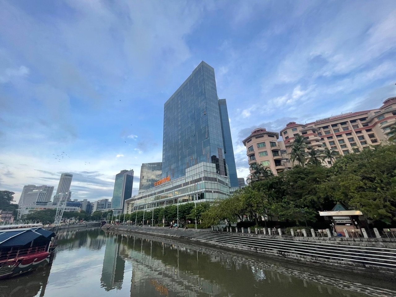
Things to do near Clarke Quay MRT: enjoy a free walk beside the Singapore River, photograph Read Bridge and the conserved waterfront warehouses, look for the Fire Fish heritage mural, follow the National Heritage Board’s Singapore River Walk and stop for a riverside meal if it suits your budget. Clarke Quay MRT (NE5) is on the North East Line, with Clarke Quay Central close to the station and CQ @ Clarke Quay across the water at 3 River Valley Road. You do not need a river-cruise ticket or a nightclub booking to enjoy the neighbourhood.
For the most useful 90-minute free route, begin at Clarke Quay MRT and the public promenade beside Clarke Quay Central, cross Read Bridge or another permitted pedestrian crossing, observe the warehouse façades and Fire Fish mural around CQ @ Clarke Quay, and return along a comfortable stretch of the riverside. For a longer visit, continue towards Boat Quay or explore more of the Singapore River Walk. The National Parks Board describes the full Singapore River Promenade park connector as 2.4 kilometres from Kim Seng Road to North Boat Quay; it is not necessary to complete that entire length to have a good outing.
Quick answers:
- Station: Clarke Quay NE5, North East Line; it is not a Circle Line interchange.
- Best free attraction: Singapore River promenade, public bridges, conserved warehouses and permitted exterior art views.
- Best first stop: Clarke Quay Central, 6 Eu Tong Sen Street, then the public riverfront.
- Best heritage photo: Read Bridge and CQ @ Clarke Quay’s conserved godowns, including the Fire Fish mural where publicly visible.
- Best time for photographs: late afternoon into dusk if the weather is safe; the promenade lights are listed 7pm–7am.
- Full park connector: 2.4 kilometres, wheelchair-friendly according to NParks; choose a shorter section for young children or seniors.
- Optional river cruise: Singapore River Cruise lists about 40 minutes, adult S$28 and child (3–11) S$18 at the time checked, with operating jetties subject to change.
- Current operating jetties: Clarke Quay, Read Bridge, Bayfront South and Clifford Pier only, according to the operator.
- Safety: the promenade is public but restaurant terraces are not necessarily free seating; respect riverside railings, cyclists, rain and after-dark crowds.

Choose a Clarke Quay outing that matches your real purpose
Clarke Quay can mean the MRT station, Clarke Quay Central mall, the restored CQ @ Clarke Quay precinct, the riverside footpath, a restaurant booking or a ticketed boat tour. The names overlap, but the visitor experience is not the same. Someone looking for a quiet free sunset walk needs different directions and expectations from a person booked on a river cruise.
| Your reason for visiting | Start with | Keep the route sensible |
|---|---|---|
| Free riverside scenery | Public promenade | Short out-and-back route; no ticket |
| Local history and buildings | Read Bridge, warehouse façades | Use NHB trail interpretation |
| Photography after sunset | Riverside bridges and public viewpoints | Allow dusk and crowd buffer |
| Family art discovery | Fire Fish mural and public exterior art | Do not block circulation or business doors |
| Paid water experience | Confirmed operating cruise jetty | Check ticket and departure before arriving |
| Meal with a view | Current restaurant and menu | Public seating and restaurant seating differ |
The best plan has one main outcome and one optional extension. A relaxed 45-minute waterfront observation followed by a meal can be satisfying. So can a longer heritage route. Problems begin when a guide promises that ten attractions are “right outside the MRT”, regardless of which bank they occupy or how much energy a family has.
For this guide, the main subject is the free river walk and what you can learn from it. The existing eduKate Clarke Quay MRT station guide provides detailed exits, shops and a general directory; here we focus on choosing a comfortable experience without unnecessary expense.
Arrive at NE5 and identify the side of the river you need
Clarke Quay MRT (NE5) is a North East Line station. The adjacent commercial building Clarke Quay Central is at 6 Eu Tong Sen Street. It is convenient for an initial meeting, toilet break or sheltered stop. CQ @ Clarke Quay is a different development at 3 River Valley Road, across the river. Do not tell friends to meet at “Clarke Quay” without specifying which of these places you mean.
For a free walk, follow present station wayfinding towards Clarke Quay Central and the public riverside. Look for a safe marked bridge crossing before heading to the conserved warehouse precinct. Never infer that a restaurant advertised in CQ @ Clarke Quay is at the same exit as the shopping centre. Map apps may use the same area name while placing the destination on opposite banks.
The operator describes CQ @ Clarke Quay as about five minutes’ walk from NE5 under ordinary conditions, but this is an estimate. Congestion, traffic lights, a stroller, wheelchair route or a large group will affect the pace. Check the exact venue address and an accessible crossing before leaving the station if mobility matters.
A family should agree on a fixed meeting point before splitting up to buy food or look at shops. The exit is a working transport area; do not obstruct the escalators and gates while looking at maps. If visiting later in the evening, note that busy commercial venues may attract larger crowds than the public footpath itself.
The CQ @ Clarke Quay official directions and NParks Singapore River Promenade guide provide useful starting points. Choose the actual first stop before deciding which bridge to cross.
Free stop 1: the public Singapore River promenade
Singapore River Promenade is a public park connector, not the private outdoor terrace of any particular restaurant. NParks identifies a 2.4-kilometre wheelchair-friendly route running from Kim Seng Road to North Boat Quay, with lighting listed from 7pm to 7am. These figures describe the larger connector, not a recommended mandatory route for every visitor starting at Clarke Quay MRT.
Begin with a short stretch. Walk along a public path, look towards the warehouses and bridges, and choose a turnaround point based on how the group feels. The riverside is a place to observe the movement of people, changes in architecture and the relationship between water and a city. You need not order an expensive riverside meal to appreciate the setting.
Public promenades and adjoining businesses share a waterfront but have different rules. A table inside a restaurant’s boundary is for customers; steps or open seating may be public only where the current signs allow. Do not remove chairs, set up picnic equipment in commercial areas or crowd an entrance. Treat every space according to its purpose.
Children may notice boats, reflections and bridges. Ask them to describe how the colour of the river changes between late afternoon and night, or why a low bridge and a tall bridge might serve different needs. Older students can ask how people travel between banks and why commercial premises face the waterfront. These questions turn a short walk into an introduction to geography and design.
In rainy weather, the same riverside can become slippery. Stay back from edges and do not lean out to photograph a boat. During lightning, leave exposed footpaths for suitable shelter. The river will still be there on another day.
Free stop 2: Read Bridge and the importance of crossing a river
Read Bridge is a useful historical stop because it reminds visitors that the Singapore River was once a working transport corridor. Bridges mattered to commerce, movement and the lives of people on both banks. The National Heritage Board’s Singapore River Walk material examines the bridges as infrastructure as well as landmarks. The story is more interesting than simply taking a photograph of an attractive crossing.
When travelling between Clarke Quay Central and the conserved warehouses, use a permitted pedestrian crossing such as Read Bridge where it suits your chosen route. Stop only in a location that leaves adequate space for others. A bridge is a transport link, not a photography platform reserved for a group. Watch for other walkers and permitted cyclists.
CapitaLand’s 2024 precinct transformation added upgraded seating near the Read Bridge landing and an accessibility ramp, drawing on the bridge’s association with public storytelling. This is a good example of how a place can preserve a story without freezing its physical design. Visitors might notice that the contemporary seating is a new response to an older social role.
One learning question for children is: “What would happen to a riverside district if people could not cross the water easily?” Invite possible answers about jobs, markets, homes and friends. For secondary students, ask how bridge height or location could affect boats and why a city’s transport needs may change over time.
Consult NHB’s Singapore River Walk and the CapitaLand redevelopment account for documented history rather than guessing at the age or original function of a particular structure.
Free stop 3: conserved warehouses and the Fire Fish mural
CQ @ Clarke Quay is a conserved riverside development with restored shophouses and former warehouses, known in the site’s management material as The Warehouses, The Riverfront and The Circuit. The distinction is useful: an old building may now house shops or food and entertainment businesses while still displaying evidence of its former economic function.
The Warehouses zone, Block B, includes the Fire Fish mural by Singapore artists Yip Yew Chong and tobyato. CapitaLand explains that the work draws on Clarke Quay’s historical association with the Teochew community, the firewood trade, distinctive red-and-white bumboats and storytelling near Read Bridge. The design is a contemporary artistic interpretation, not a surviving nineteenth-century painting.
Visitors can look for the public-facing mural where access permits. Its location and visibility may be affected by site events or refurbishment, so do not promise an unimpeded view from one specific camera angle on every day. Respect shopfronts and do not block people entering restaurants or carrying deliveries. These are active businesses, not an outdoor film set.
A useful child-friendly exercise is to separate observation from interpretation. Ask: “What colours and shapes do you notice?” Then read the operator’s explanation and ask what elements refer to the river’s past. This helps children understand that art can refer to history without depicting every detail literally.
For teenagers, compare the historical godown with its current use. A warehouse needed to store goods close to river transport; a modern restaurant requires seating, ventilation, pedestrian access and a different interior experience. Which architectural features were preserved, and which systems had to be adapted? The answers make a city walk relevant to design, history and economics.
The Singapore River used to be a commercial artery
National Heritage Board describes the Singapore River as an artery of commerce from 1819 and as a place that brought together people trading and working in the port city. Goods, people and boats moved through a relatively compact waterway. Warehouses along the banks were part of a larger network of loading, storage and distribution. The modern view of a leisure waterfront can obscure how hard and practical that work once was.
Try viewing the river as an old transport system. A boat could bring materials to a quay, workers would unload goods, a warehouse would store them and traders or buyers would arrange the next journey. Each step depended on time, space, labour and suitable access. That is a useful explanation for children because it connects an attractive present-day location to the reasons buildings were constructed there.
The Singapore River Walk traces these stories across several quays and bridges. Its map is not a command to cover the entire river in one trip. You can read about the wider system, then use Clarke Quay as one visible example of how the past and present meet.
Careful historical language matters. Do not describe every current warehouse façade as unchanged from 1819, or suggest the same businesses have operated continuously for two centuries. Development, rebuilding, conservation and new uses have altered the river. The continuity lies in the place and the stories recorded about it, not an imaginary absence of change.
Ask an older child what might cause a working port to move away from a narrow urban river as a city grows. There are many possible explanations involving vessel size, infrastructure, land use and technology. Those explanations need evidence and historical context. A good walk raises the question without pretending a single sign proves everything.
Why the Singapore River clean-up changed the area
It is difficult to appreciate the current riverside without understanding that it has been transformed. National Heritage Board identifies a major clean-up programme that concluded in 1983, after work connected with broader urban change. Its historical explanation traces the programme’s origins through planning in the late 1960s and a major government push in 1977. The change involved more than picking up visible litter.
A city waterway can be polluted by many interacting activities. Improving its condition requires choices about drainage, land use, industry, waste disposal and enforcement, alongside long-term investment. Visitors should not infer the chemical condition of the river from one moment’s appearance. Clear-looking water is not by itself proof that the water is safe to swim or drink.
For children, the clean-up is a useful example of environmental systems thinking. Ask: “If we remove a floating plastic bottle today, have we solved the whole problem?” The answer is no, because new waste can enter unless sources are controlled and people change their behaviour. Invite children to think about prevention as well as clean-up.
The river’s later transformation also affected the meaning of the quays. Buildings and spaces once associated with transport and labour became places for leisure, food, public walking and heritage interpretation. That change is not purely a happy ending or a single simple story; it had different consequences for workers, businesses and nearby communities. A thoughtful reader should be willing to learn more.
Use NHB’s Singapore River history and clean-up account for the documented background. The material makes the river a better learning destination than an uncontextualised photo spot.
Daylight, blue hour and night: a three-stage photography walk
Clarke Quay looks different as the light changes. In late afternoon, the buildings’ rooflines and colours can be observed more clearly. At dusk, sky colour and artificial lighting combine; after nightfall, reflections and lit façades become the main visual elements. A family can enjoy those changes without purchasing a boat ticket.
Begin with a safe public viewpoint and choose one building or bridge to photograph more than once. Compare the images rather than roaming continually in search of the perfect backdrop. Which details became easier to see after the lights came on? Which became less visible? Children can describe colour and contrast, while older students can experiment with exposure settings on a phone.
NParks lists the Singapore River Promenade’s lighting period as 7pm–7am. This tells you about the connector, not whether every commercial façade will light up or whether a restaurant will remain open. Event lighting and decorative installations can change. Do not promise that a special projection or temporary installation will be operating simply because it appeared on social media last month.
Avoid large tripod setups that obstruct shared paths. If your group wants to photograph a bridge, stand off the main pedestrian route and leave enough space for people using mobility aids. Photographing people in restaurants or passers-by raises privacy and courtesy concerns; focus on architecture and avoid intrusive images of individuals.
At night, agree on the return station and a meeting point. More people may be using the area for nightlife, so the atmosphere can be louder than during a daytime heritage walk. A family with young children may be happier visiting before late-night activity increases.
Boat cruise or free walking route: what is worth paying for?
Singapore River Cruise offers a sightseeing boat experience commonly advertised as 40 minutes, passing parts of the river and Marina Bay. At the time of review, its official page lists an adult standard ticket at S$28 and a child ticket for ages three to eleven at S$18. A special promotional or residency discount may apply only to eligible visitors and should not be treated as the universal fare.
For someone with limited time who particularly wants to experience the river from the water, that may be a worthwhile ticket. For a family whose priority is a low-cost walk, the public promenade gives plenty of waterfront views free of cruise admission. A boat changes the vantage point and the travel experience; it does not magically make the underlying heritage more meaningful for every visitor.
There is a crucial operational detail: the operator says it is currently using Clarke Quay, Read Bridge, Bayfront South and Clifford Pier jetties only. Other jetties shown on historic route maps are closed until further notice. A visitor should identify the precise operating boarding point before travelling. Tickets, boat schedules and weather procedures can change.
For official details use Singapore River Cruise: fares and operating times and the operating-jetty notice. A river-cruise ticket may have an exact date and time with restrictions on late boarding. Read the conditions before purchasing, especially when travelling with children or visitors whose mobility requires assistance.
Do not confuse a cruise jetty with public waterfront seating. Being near a boat does not permit boarding without a ticket, and being on a public walkway does not mean a boat operator is serving every landing nearby.
How to enjoy food without turning a free walk into an expensive evening
Clarke Quay has many places to eat, including restaurants and bars along the waterfront. Some offer views and atmosphere, while others cater to nightlife. Menus, prices, set meals and opening times change. A reliable guide should explain how to choose rather than invent a fixed list of “best meals under S$10” that may not exist at those venues.
If the river walk is the main purpose, decide the food budget before you enter the restaurant area. You might choose a meal in Clarke Quay Central, a particular booked restaurant or a stop at another convenient food centre on the route. For young children, settle the meal timing before a long dusk walk; hunger can turn a pleasant view into a tiring experience very quickly.
Restaurant patios overlooking the river may be reserved for customers. A visitor is welcome on permitted public footpaths but should not occupy a table, move chairs or obstruct a service area without permission. If a venue is busy, do not insist that the perfect seat is essential. The free riverside view is still available from appropriate public areas.
For dietary restrictions or allergies, contact the individual restaurant or ask the staff about ingredients. Do not infer that a dish is suitable merely because the menu resembles a familiar cuisine. If the purpose is a family-friendly meal, check whether the venue is appropriate for children’s ages and whether its ambience changes later at night.
A low-budget outing can be entirely successful with a short walk, water and a meal somewhere convenient. Spending more may provide additional comfort or a particular experience, but price is not a measure of how much a family learns about Singapore’s river.
Family itineraries: 45 minutes, two hours and half a day
45 minutes — the compact free riverside route
Arrive at Clarke Quay MRT, identify the public promenade near Clarke Quay Central and enjoy a short walk towards an appropriate bridge viewpoint. Observe the architecture and river for a few minutes, then return to the MRT. This works for a family with toddlers or a group that wants a short outing between appointments.
90 minutes — bridges, buildings and the mural
Start at the station, walk beside the river, cross Read Bridge and view the conserved warehouses and Fire Fish mural from permitted public areas. Read one piece of NHB history before returning. Add a short rest or snack if needed. The route remains flexible: you can reverse it according to the weather and walking comfort.
Two to three hours — sunset and an optional meal
Begin in daylight, spend time on both sides of the river and choose a public viewpoint for dusk. Compare how the façade colours and reflections change, then finish with a pre-selected meal or an indoor pause. If the group has limited walking stamina, use a smaller portion of the promenade instead of trying to reach Boat Quay.
Half a day — a longer Singapore River heritage extension
Use NHB’s Singapore River Walk map to extend towards Boat Quay or another section, then plan where to end and which rail station best serves the return. Allow time for historical markers, photographs and rest. A full river connector is longer than the immediate Clarke Quay cluster; it should be planned as a separate activity.
Paid-boat alternative
If the main activity is the cruise, identify the current operating jetty and ticket conditions first. Make a short pre-boarding promenade walk optional, not mandatory. You do not want to risk missing a timed departure while chasing a picture across the river.
Walking with grandparents, children, strollers and wheelchairs
NParks describes the full Singapore River Promenade park connector as wheelchair-friendly. That is helpful, but the path from a particular MRT exit to every bar, mall, footbridge or jetty may have separate steps, gradients or temporary diversions. A visitor with mobility needs should inspect the whole route, especially the crossing used to reach the other side of the river.
For a family with a stroller, the practical questions are where the station lift opens, whether the chosen bridge is step-free and where toilets and rest areas are located. A route that looks short on an aerial map may involve unnecessary crossings if you start on the wrong bank. Choose the simplest accessible circuit and skip any optional steps.
Older relatives may enjoy sitting near the river more than walking the whole 2.4 kilometres. Ask them before committing to a long route. A short, comfortable observation stop still delivers much of the riverside’s appeal. At dusk, bring the group’s attention to uneven paving and the position of barriers along the river edge.
Children should stay close to adults near water and not run between restaurant tables or public path users. The river is not a play pool. Do not lean over railings for photographs, chase boats along the edge or enter restricted mooring or jetty spaces. This is especially important when distractions increase after dark.
For a paid boat ride, speak to the operator about accessibility before buying. A wheelchair-friendly riverside path is not proof that every cruise vessel or boarding jetty can accommodate all needs.
Rainy days, lightning and the difference between a park and a venue
Singapore’s weather can change quickly, and an evening planned around reflections on the river can become unsuitable in heavy rain. If lightning is nearby, leave exposed waterfront paths and bridges for safe shelter. Do not shelter under a lone tree or stay beside the river simply because a tour group is still taking photographs.
Clarke Quay Central can provide a convenient indoor alternative when it is open, but shops and restaurants have separate operating hours. A wet-weather plan should not depend on one unverified store remaining open. If you wish to continue with heritage learning, discuss the river’s history while seated in a suitable public or commercial space, respecting the rules of that venue.
After rain, surfaces may be slippery, especially at steps leading toward the waterfront. Avoid racing or carrying heavy camera equipment across damp stairs. A quiet post-rain photograph is not worth a fall. For young children, keep the outing short and assess whether their footwear is suitable.
If a major event changes access to CQ @ Clarke Quay, follow the organiser’s and operator’s present signage. A published guide cannot guarantee access to every publicly visible mural or riverfront area on a concert, private-event or maintenance day.
When the outing is time-sensitive, check the forecast and the actual attraction’s operational information before leaving home. A public walking route may remain generally accessible while a particular boat departure or commercial activity has been suspended.
What children learn from bridges, trade and a cleaned-up river
A neighbourhood walk can introduce geography, history, design, science and writing without a formal lesson. The key is to connect a visible observation to one useful explanation, rather than presenting the child with a long list of facts that feel unrelated to the trip.
Ages 4–7: name things precisely
Ask the child to find a bridge, boat, warehouse-shaped building and riverbank. Let them describe a colour or shape. Offer words such as reflection, waterfront and crossing when the child needs them. End after a few observations, before it becomes tiring.
Primary 3–6: understand the journey of goods
Explain a simple chain: a boat carries something to a river, workers unload it, a warehouse stores it and another buyer receives it. Ask what could delay the journey. This is a gentle connection between Mathematics, time, economic activity and the practical design of transport systems.
Secondary students: evaluate change
Compare the river’s former commercial roles with today’s leisure environment. Why did the city clean the waterway? Who benefited? Which economic functions moved elsewhere? Use NHB history rather than guessing. Students can discuss possible reasons, identify what needs evidence and practise avoiding sweeping claims about the past.
Art and visual literacy
Look at the Fire Fish mural and ask which parts are a direct illustration and which are imaginative. If the mural refers to the area’s Teochew history and river transport, how does the artist combine contemporary style with old stories? Art does not need to reproduce a historical photograph to interpret the past.
At home: the two-minute read-back
Ask each person to explain one thing they saw, one sourced fact and one question they would like to explore. This is more useful than making a child write a lengthy report about a relaxing outing.
Did you know? Five Clarke Quay details worth remembering
Clarke Quay MRT is NE5, not a three-line interchange. The wider riverfront can be approached from more than one station, but that does not change the station’s actual rail line.
The Singapore River Promenade is a 2.4-kilometre park connector. Its full length is not a compulsory walking itinerary for a family arriving at Clarke Quay.
Read Bridge has a social history as well as an engineering role. The revitalised landing refers to the earlier use of the area for community storytelling.
The Fire Fish mural is contemporary art referencing older river traditions. It brings together artistic motifs associated with firewood, bumboats, heritage and storytelling.
Only four Singapore River Cruise jetties are currently operating. Older maps showing every landing as active can be misleading; verify the actual boarding point before booking.
Frequently asked questions about things to do near Clarke Quay MRT
Can I enjoy Clarke Quay without spending money?
Yes. Public riverfront walking areas, exterior heritage architecture and suitable public viewpoints can be enjoyed free of attraction admission. Shopping, dining and boat rides are separate expenses.
Is Clarke Quay MRT connected to the Downtown Line?
No. Clarke Quay NE5 is on the North East Line. Fort Canning DT20 is another station relevant to parts of the wider precinct.
How long is the Singapore River Promenade?
NParks lists the full park connector as 2.4 kilometres, from Kim Seng Road to North Boat Quay. You can walk a much shorter section around Clarke Quay.
What is the best free sunset viewpoint?
A permitted public riverside position near Read Bridge and the conserved warehouses provides views of the river and buildings. The most comfortable location depends on crowding, weather and your chosen route.
Is Read Bridge worth visiting with children?
Yes, for a short observation of river infrastructure and local history. Supervise children near the water and leave passage clear for others.
Where is the Fire Fish mural?
It is associated with the conserved Warehouse Block B façade at CQ @ Clarke Quay. Follow present public access signs and do not enter commercial or restricted areas without permission.
How much is Singapore River Cruise?
The operator currently lists S$28 adult and S$18 child (ages 3–11) for its standard approximately 40-minute river experience. Check current tickets, discounts and conditions before purchase.
Which river cruise jetties are open?
The current official notice lists Clarke Quay, Read Bridge, Bayfront South and Clifford Pier. Other listed jetties are closed until further notice.
Is Clarke Quay suitable for grandparents?
Yes, particularly as a short promenade and meal outing. Choose step-free crossings, allow rest and do not insist on the entire connector distance.
Is Clarke Quay only for nightlife?
No. The riverfront also offers public walking, architecture, history and art. Atmosphere and crowd levels may differ substantially between daytime and late evening.
Can I walk to Boat Quay?
Yes, it is a possible longer riverside extension. Allow additional time, decide where you will end and use an appropriate crossing or return station.
Is the whole river route accessible to wheelchair users?
NParks describes the promenade connector as wheelchair-friendly, but individual restaurant entrances, bridges and boat jetties can have separate access restrictions. Verify your exact route.
What if it rains heavily?
Use appropriate shelter and avoid exposed bridge or waterfront areas during lightning. A shorter day is preferable to unsafe walking.
Official sources and next useful eduKate guides
Information reviewed 6 November 2026. Temporary events, commercial tenancies and cruise operations can change. Use the operator’s most recent notice before a date-specific outing. This guide is deliberately separate from a general MRT exit guide: it helps visitors choose a free walk and understand why the river matters.
- NParks — Singapore River Promenade, distance, lighting and accessibility
- National Heritage Board — Singapore River Walk and map
- National Heritage Board — river history and clean-up
- CapitaLand — CQ @ Clarke Quay zones and precinct
- CapitaLand — Warehouse restoration and Fire Fish mural
- Singapore River Cruise — official ticketing and times
- Singapore River Cruise — currently operating jetties
- eduKate — Clarke Quay MRT practical station guide
- eduKate — Chinatown walking and heritage alternative
If you enjoy the river’s history, return on another day and explore a different quay. A city becomes easier to understand through a sequence of small, thoughtful walks, not one exhausting list of must-see places.