
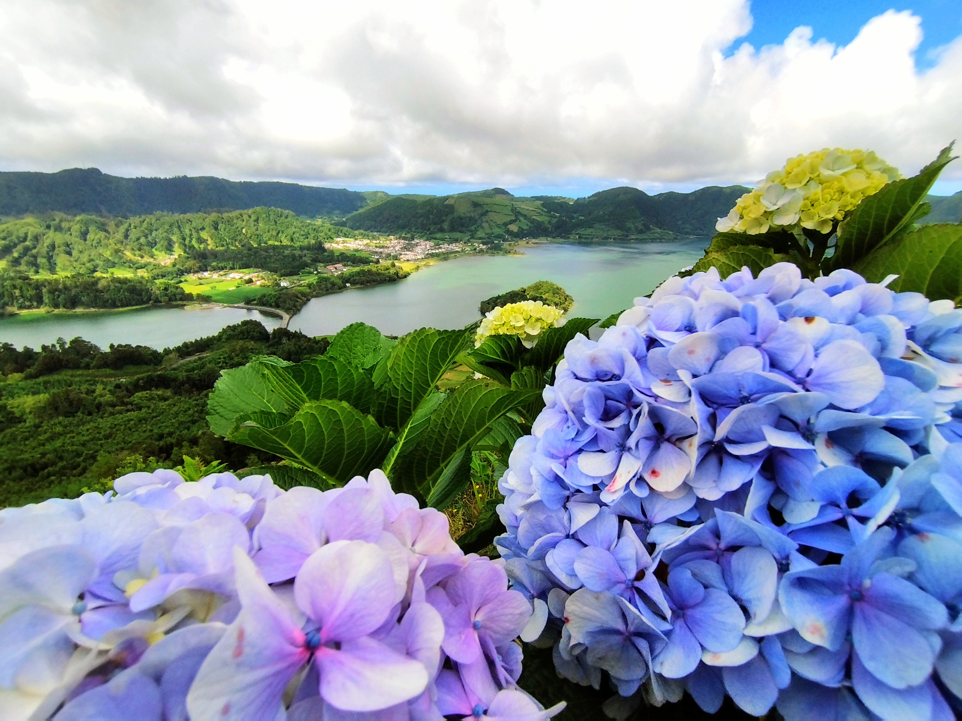
Quick answer: Begin the Azores with Ponta Delgada’s harbour culture, Sete Cidades’ double-lake caldera, the wild Lagoa do Fogo and the geothermal valley of Furnas on São Miguel. Then choose whether your next island should be Terceira for UNESCO-listed Angra do Heroísmo and volcanic caves, Pico for a UNESCO vineyard landscape and Portugal’s highest mountain, Faial for Capelinhos volcanic history, or Flores for remarkable waterfall scenery. These are ten choices across several islands, not a continuous road trip.
The Azores are nine Portuguese islands in the North Atlantic. Volcanoes, lakes, basalt walls, farms, maritime trade, whaling history and a modern conservation economy create very different experiences on different islands. UNESCO lists the central zone of Angra do Heroísmo and the Pico Island Vineyard Culture as cultural World Heritage properties. These are distinct from the broader Azores UNESCO Global Geopark or other protected natural areas, and a green crater lake is not automatically a World Heritage site.
Transport and weather shape everything. Ferry services link certain islands and routes, while domestic flights connect others; seasonal sea conditions and fog can cancel excursions or obscure viewpoints. The official Trails of the Azores service displays live closures and maintenance alerts. Choose a realistic number of islands, check the current lake-viewpoint or mountain access rules, and use qualified local operators for volcanic caves, challenging trails and whale watching.
Check Azores trail access and weather before travelling
The official Trails of the Azores alerts identify closed and maintained routes. Crater viewpoints, regulated volcano caves and offshore trips have different access requirements. This guide describes heritage and natural settings; it does not guarantee opening, safe water, a permitted climb or available inter-island transport.
eduKate · World heritage and learning
Find your reading route through the Azores
Ten places across several islands, with realistic transport and environmental considerations.
ROUTE 1 · PLACES 1–3
São Miguel: city, caldera lakes and geothermal valley
Learn about each place and continue.
ROUTE 2 · PLACES 4–6
Terceira and Pico: historical cities and working landscapes
Learn about each place and continue.
ROUTE 3 · PLACES 7–10
Faial and Flores: volcanic change and Atlantic waterfalls
Learn about each place and continue.
Choose your ten places
These are research-led choices across different islands, not a single drive. Check island transport and site access before deciding which fit your journey.
| Place | Why choose it? |
|---|---|
| 1. Ponta Delgada harbour and historic centre, São Miguel | Begin with the archipelago’s transport and cultural gateway. |
| 2. Sete Cidades caldera and Vista do Rei lookout, São Miguel | Compare volcanic topography with cultivated land around two lakes. |
| 3. Lagoa do Fogo and its mountain viewpoint, São Miguel | See a protected crater lake with carefully controlled visitor access. |
| 4. Furnas Valley, fumaroles and Terra Nostra garden, São Miguel | Study geothermal activity alongside gardens and traditional food. |
| 5. Angra do Heroísmo historic centre, Terceira | Read an Atlantic port city inscribed by UNESCO for its maritime history. |
| 6. Algar do Carvão and Terceira’s volcanic cave country | Explore an unusual volcanic interior through a managed visitor experience. |
| 7. Landscape of the Pico Island Vineyard Culture, Pico | Understand a UNESCO landscape built with black basalt stone walls. |
| 8. Mount Pico highland and official climbing area | Compare Portugal’s highest mountain with a protected agricultural coast. |
| 9. Capelinhos Volcano and interpretation centre, Faial | See the legacy of a twentieth-century eruption that changed the coast. |
| 10. Fajã Grande and Poço da Ribeira do Ferreiro, Flores | Experience waterfall cliffs and a community on the western edge of the Azores. |
1. Ponta Delgada harbour and historic centre, São Miguel
Why this place deserves time. Ponta Delgada is one of the best places to understand the Azores as a society rather than simply a destination for scenic lakes. Its harbour, public squares, churches, markets and commercial streets reflect the importance of maritime routes and modern regional services. The town also introduces the island’s food and farming traditions, from pineapple cultivation to tea production farther along the São Miguel roads. Reading the waterfront as a working place creates context before departing for remote scenery.
What to notice. Walk in authorised public areas around the historic centre and notice how older stone façades sit beside functioning shops, municipal buildings and modern transport infrastructure. Compare the harbour and central streets to understand why people and goods have congregated here over generations. At a market, ask sellers about local produce rather than inferring that everything on a stall was grown on the island. Respect the privacy of residents and workers.
The learning question. Sketch the relationship between the port, the town centre and the island’s main road network. What does an ocean archipelago need in addition to beautiful landscapes to support everyday life? Compare a local agricultural ingredient with an imported product and ask how transport changes price, availability and seasonality. A good history note distinguishes the facts on a heritage sign from assumptions made by looking at a building.
Access and planning
Confirm current museum and market opening separately, and plan vehicle collection or other transport around airport and ferry schedules. Ponta Delgada is a useful base for several São Miguel outings, but the island’s viewpoints, hot springs and trails still need their own daily weather decisions. Keep clear of active port operations and ask permission before photographing identifiable people.
2. Sete Cidades caldera and Vista do Rei lookout, São Miguel
Why this place deserves time. Sete Cidades is famous for the blue and green appearances of its lakes, which occupy an enormous volcanic caldera with a village and working farmland. The official Azores tourism site identifies the Protected Landscape of Sete Cidades Lake as one of Portugal’s celebrated natural sights and explains the Vista do Rei viewpoint. That is a scenic and protected-area recognition, not a UNESCO World Heritage inscription. The site’s strength is the relationship between crater geometry, lake water, fields and daily life.
What to notice. From permitted viewpoints, compare the lakes’ apparent colours with the vegetation and changes in cloud cover. Colour can vary with light, algae, water conditions and viewing angle, so the scene is not a guaranteed two-tone photograph. Identify the village and roads in the caldera and consider how people farm and move through a landscape shaped by earlier volcanic processes. Stay away from exposed roadside edges and private pastures.
The learning question. Draw a contour sketch of a crater-shaped basin, two lakes and a settlement. How might the surrounding high rim affect transport and water drainage? Compare the scientific explanation of volcanic calderas with the local legend described in the official visitor material, keeping them as different types of story. A single photograph cannot establish long-term water quality or change.
Access and planning
Check the current local road, parking and trail conditions. Some popular lookouts may have restricted parking or visibility because of weather. Follow local trail notices rather than wandering off paths to reach a supposedly better photograph. A shorter viewpoint visit can be worthwhile even if low clouds make the full panorama invisible.
3. Lagoa do Fogo and its mountain viewpoint, São Miguel
Why this place deserves time. Lagoa do Fogo is a striking lake surrounded by steep green slopes in central São Miguel. The official tourism service notes its long-standing nature-reserve status and points travellers toward a shuttle system for some visits. Its protected setting differs from the inhabited Sete Cidades caldera: broad mountain views can make it appear remote and untouched, but active conservation and visitor management are necessary. Understanding those boundaries is part of a responsible trip.
What to notice. From an open public lookout, observe the shape of the crater basin and how mist travels across the lake. Vegetation and steep slopes create habitats that should not be trampled or approached through informal paths. Weather conditions can be markedly different from the coast and visibility may disappear suddenly. Water appearing deep or clear does not demonstrate safety for swimming or direct access to the shore.
The learning question. Compare Lagoa do Fogo with the occupied Sete Cidades basin. Which differences in land use and routes can you see, and what would require an official land-management map to confirm? A useful science question explores how lakes collect water in volcanic landscapes and why long-term sampling is needed to assess water chemistry and ecosystem change.
Access and planning
Consult the current Azores tourism page and local shuttle information, particularly where private-vehicle access or parking is controlled seasonally. Check official trails status for any proposed descent. Stay within marked viewpoints, avoid lake-shore access unless expressly permitted and prepare for cold wind and rapid fog.
4. Furnas Valley, fumaroles and Terra Nostra garden, São Miguel
Why this place deserves time. Furnas offers one of the clearest examples of how volcanic heat intersects with human life in the Azores. The village and surrounding valley contain fumaroles, hot springs and lake landscapes. Local cooking traditions associated with geothermal heat show the practical use of natural conditions, while garden environments such as Terra Nostra create a different form of plant interpretation from a wild nature reserve. The official tourism authority describes the valley’s sulphurous smells and steaming springs as evidence of continuing geothermal activity.
What to notice. From authorised boardwalks, observe vapour rising from marked ground and compare different water or vegetation features. Never leave safety barriers to approach boiling mud or geothermal vents; gas, unstable ground and hot water can cause serious injury. In a curated garden, identify planted species using labels rather than assuming the site represents untouched native forest. Notice how tourism, village streets and thermal facilities coexist.
The learning question. Sketch a simplified subsurface geothermal system and explain why heating can reach water close to the surface without requiring an erupting volcano on the day. Compare natural geothermal processes with cultural techniques for cooking, while recognising that regulated facilities follow their own safety rules. A longer question concerns how a community manages natural hazards and visitor demand together.
Access and planning
Check Terra Nostra or thermal-pool admission, opening and suitability independently. Geothermal bathing is not appropriate for everyone and may have temperature or medical restrictions. Follow barriers near vents and avoid unlicensed water access. Arrange enough time for a considered village walk rather than combining every thermal pool and lookout in a rushed day.
5. Angra do Heroísmo historic centre, Terceira
Why this place deserves time. Angra do Heroísmo on Terceira has a central historic area inscribed on the UNESCO World Heritage List. Its urban plan, harbour setting, churches and defensive system reflect its role as a significant port of call on Atlantic ocean routes. UNESCO notes major fortifications including São Sebastião and São João Baptista, as well as the rebuilding and restoration undertaken after the 1980 earthquake. The designation applies to a defined historical centre, not the entire island or all of its buildings.
What to notice. From public streets, compare the planned urban grid with the sheltering hills and harbour bays. The architecture can show multiple phases of construction and post-earthquake restoration, so don’t claim that every visible wall is original to the sixteenth century. Read official cultural plaques and, if open, museum displays to understand the maritime and civic roles of different buildings. The town remains inhabited and working.
The learning question. Ask why an Atlantic port needed warehouses, churches, civic institutions and coastal forts. Draw a simple map showing the relationship of the two harbour basins and major defensive sites. Consider what UNESCO inscription protects and how rebuilding can conserve historical value without restoring every building to an exact past state. Good history includes ordinary residents as well as fleets and colonial authorities.
Access and planning
Check individual heritage sites, churches, fort grounds and museum opening directly. Some fortifications are active institutional areas and may have restricted public entry. Respect road traffic, religious events and residents’ privacy. A full city walking day is more informative than treating Angra as a brief island-hopping layover.
6. Algar do Carvão and Terceira’s volcanic cave country
Why this place deserves time. Terceira is known for volcanic landscapes that include Algar do Carvão, a celebrated volcanic conduit or cavern accessible under specific visitor arrangements when open. This is a rare opportunity to compare visible cave walls, different rock forms and how the underground environment differs from a crater lake seen at the surface. The site can connect tourism with geological conservation and scientific explanation, but it should never be described as a general cave that visitors may enter independently.
What to notice. During an authorised guided visit, observe how the rock walls and spaces differ from limestone caves formed mainly by solution. Stairs and wet surfaces can make movement demanding, and interior lighting may change the perceived colour of rock. Do not touch delicate surfaces, climb beyond barriers or assume access to a deep chamber is suitable for everyone. If the site is closed, interpretation at an approved museum or geopark visitor centre is a valid alternative.
The learning question. Compare two kinds of volcanic evidence: an open caldera lake and a volcanic cavity. What processes would have produced each shape, and which details would require expert geological mapping? A cave also raises conservation questions about managing visitor numbers, moisture and lighting to avoid damaging a sensitive environment.
Access and planning
Check the site’s official current booking, opening and conservation restrictions. Cave access can be limited by works, weather or capacity. Confirm physical requirements and ticketing before travelling across Terceira. Never enter closed volcanic tunnels or unofficial openings, regardless of images published online.
7. Landscape of the Pico Island Vineyard Culture, Pico
Why this place deserves time. The Pico Island Vineyard Culture is a UNESCO World Heritage cultural landscape recognised for countless small plots bordered by stone walls known as currais. These dark basalt walls help protect vines from wind and sea spray on an exposed volcanic coastline. The landscape is not merely a photogenic pattern: it reflects generations of skilled agricultural work and includes houses, cellars, paths and living producers. UNESCO describes both abandoned and still-worked plots, making the inscription an example of heritage in continuing use.
What to notice. From approved roads or guided paths, observe the unusual geometry of the stone enclosures and consider how small plots differ from large farms on other islands. Look for actively tended vines while staying out of private fields and avoiding disturbance of fragile wall fabric. Black basalt rock is an important part of the visual character, but geology alone does not explain the labour and knowledge behind the agricultural system.
The learning question. Explain how a low wall can alter wind exposure and microclimate for a crop. Compare this agricultural adaptation with food production in Furnas or São Miguel’s greener valleys. The UNESCO designation recognises human interaction with a difficult environment; a thoughtful discussion includes continued farming, preservation costs and the economic viability of local wine production.
Access and planning
Check the official mapped UNESCO property and locally managed visiting routes. Working vineyards are private businesses; arrange tastings or heritage tours appropriately rather than entering plots without permission. Some walls may be fragile, and narrow lanes can have agricultural traffic. Pico is a separate island requiring flight or boat planning.
8. Mount Pico highland and official climbing area
Why this place deserves time. Mount Pico rises dramatically above the island’s lower slopes and UNESCO vineyard coast. It is Portugal’s highest mountain and a major volcanic landscape for natural history and mountaineering. A full summit ascent is a demanding undertaking with variable volcanic terrain, steep sections and fast-changing cloud or wind. The mountain is a different travel decision from a short vineyard visit, even though both occur on Pico Island. A safe viewpoint and interpretation of the mountain’s shape can be meaningful without committing to a climb.
What to notice. From permitted lower viewpoints, compare the broad volcanic cone, summit and patterns of vegetation. Cloud can conceal the peak and change navigation quickly. Where a properly authorised ascent occurs, observe the terrain without removing rock or deviating from approved paths. Avoid treating a mountain’s apparently simple conical outline as proof that walking to the top is straightforward.
The learning question. Use elevation and contour lines to explain why a relatively short horizontal distance to the summit can involve many hours and substantial effort. Compare how vineyard walls manage wind on the coast with how exposed volcanic slopes limit vegetation at height. The educational focus is adapting to natural constraints with evidence, not simply reaching the summit.
Access and planning
Consult the official Montanha do Pico visitor and climb-control information about registration, guide requirements, weather, capacity and rescue arrangements. Do not assume a previously published hiking time guarantees safety or that summit access is automatically open. Choose a local accredited mountain guide where appropriate and turn back when conditions exceed the group’s abilities.
9. Capelinhos Volcano and interpretation centre, Faial
Why this place deserves time. Capelinhos is a striking volcanic landscape at the western end of Faial, associated with the eruption of 1957–58 that formed new land and buried parts of the older setting in ash. Its interpretation centre helps explain the physical events and their effects on island communities. The stark terrain differs from older green calderas and makes geological change visibly recent on a historical timescale. It is also a story of people adapting to disrupted homes and livelihoods, not just a dramatic line of black rock.
What to notice. From authorised paths, compare the volcanic ash, cliff and sea against older vegetated areas. The former lighthouse area helps locate the coastline as it existed before parts of the eruption landscape developed. Do not assume every exposed slope is stable or open; loose ash and coastal cliffs require caution. Read the centre’s displays to distinguish contemporary eyewitness accounts from scientific reconstructions.
The learning question. Create a before-and-after shoreline sketch using official photographs and a present-day map. Ask how scientists know which deposits came from which phases of the eruption. Compare Capelinhos with the much older landscapes of Sete Cidades and Mount Pico, identifying how the timescales differ. Include the people affected in the account rather than treating volcanic change as only a spectacle.
Access and planning
Confirm the interpretation centre’s opening and any ticket or access restrictions. Wind and wave exposure on western Faial can make outer viewpoints unpleasant or dangerous. Stay on designated paths, protect volcanic surfaces and allow time for displays that explain the 1957–58 event.
10. Fajã Grande and Poço da Ribeira do Ferreiro, Flores
Why this place deserves time. Flores is known for steep green cliffs and abundant waterfalls, including the setting at Poço da Ribeira do Ferreiro near Fajã Grande. The island is a separate travel commitment at the western edge of the archipelago, with a different scale and rhythm from São Miguel. Its appeal is not simply a collection of waterfall photographs; pasture, small villages, changing rain and the management of protected trails form a distinctive human and environmental story.
What to notice. From legal established paths, observe waterfalls descending a steep vegetated wall and how smaller streams interact with rock and pooled water. Some trails can be muddy, damaged or inaccessible following rain, and the official Azores trail-alert page has listed closures on Flores routes. A waterfall seen from a distance is not proof that its plunge pool is safe for swimming. Respect people working in agricultural areas and avoid cutting across private land.
The learning question. Ask how high rainfall, slope and rock structure contribute to multiple narrow waterfalls. Sketch the vertical face and mark different watercourses without guessing exact heights. Compare Flores’ lush landscape with Capelinhos’ ash terrain. Then consider how weather makes travel to a remote island uncertain even when the flight distance looks manageable on a map.
Access and planning
Check official trail alerts, road conditions and local guidance before walking to Poço da Ribeira do Ferreiro. The surrounding island has limited services and may face flight and marine cancellations. Allow spare time and avoid assuming that Corvo, another remote western island, can always be added as a casual same-day boat excursion.
Plan a thoughtful Azores journey
Choose islands before attractions. São Miguel supports a meaningful multi-day first visit. Terceira and Pico add separate cultural and mountain journeys; Faial and Flores deserve dedicated time. The Azores have nine islands, and a ten-place list cannot fairly claim to exhaust them all. Corvo, São Jorge, Graciosa and Santa Maria are legitimate alternatives based on interests and connections.
Respect the two UNESCO World Heritage properties. Angra do Heroísmo’s central zone and Pico’s vineyard landscape are distinct cultural inscriptions. Other extraordinary landscapes belong to reserves, geopark designations or different protections; avoid labelling every crater UNESCO World Heritage.
Check trail closures on the day. Trails of the Azores publishes closures, maintenance and route notices, with entries that can change after weather damage. A previous year’s successful hike gives no permission to cross a current barrier.
Treat geothermal and volcanic environments seriously. Furnas fumaroles can expose visitors to dangerous hot ground or gases. Mount Pico is a demanding mountain with registration or control requirements. Volcanic caves are regulated visitor spaces, not opportunities for casual underground exploration.
Plan respectful marine experiences. The Azores tourism authority highlights whale watching, but wildlife sightings are variable and operators must comply with distance and interaction rules. Avoid chasing, feeding or touching animals. Bad sea conditions make cancellation a responsible decision.
Build weather margins into transport. Sea crossings and flights can be delayed or cancelled, especially on remote islands. Do not commit to a hard-to-reach waterfall or crater immediately before an onward flight. Confirm schedules for the exact island and date rather than relying on a generic map.
Frequently asked questions
How many islands are in the Azores?
The Azores are made up of nine main volcanic islands. Their distances and transport links differ; do not assume all nine can be reached quickly from a single base.
Which island is best for a first visit?
São Miguel gives visitors a broad introduction with Ponta Delgada, Sete Cidades, Lagoa do Fogo and Furnas. Other islands add historic cities, vineyards, remote landscapes or marine activities.
Are Sete Cidades and Lagoa do Fogo UNESCO World Heritage Sites?
No. They have important scenic and environmental protections, but the Azores’ World Heritage cultural properties are Angra do Heroísmo’s central zone and the Pico Island Vineyard Culture.
Can I climb Mount Pico without preparation?
Do not assume so. The climb is strenuous, weather-sensitive and subject to official visitor and mountain controls. Check the current registration and guide options.
Are Azores whale sightings guaranteed?
No. Marine life is wild and conditions change. Use a reputable local operator that follows wildlife protection rules, and regard an educational boat trip as worthwhile without a guaranteed species sighting.
What if an Azores trail is closed?
Follow the official Trails of the Azores alerts and choose an authorised alternative viewpoint, museum or shorter route. Never bypass a closure to reproduce a photograph.
Build understanding through evidence
The Azores allow a particularly strong comparison of geology and human adaptation: crater lakes on São Miguel, the historic harbour of Angra, basalt-walled vineyards on Pico, the recent volcanic landscape of Capelinhos and the waterfall cliffs of Flores. A good note distinguishes observed physical forms from the evidence needed to explain their formation and age. The island’s people, farms, ships and protected landscapes belong within the same story.
For a family reasoning activity, choose São Miguel, Pico and Flores on a map, identify the exact transport required between them and explain why the shortest straight line does not guarantee a quick visit. Show assumptions and cite reliable schedules; eduKate’s Secondary 1 Mathematics Tutor Clementi | Small Groups Tutorials similarly emphasises explaining the working rather than guessing the answer.
Continue learning about the Azores
Top 10 Things to Do When Visiting and Touring Azores · Top 10 Things to Learn When Visiting and Touring Azores · World Country Directory
Sources and current information
Sources reviewed on 19 October 2026 (Singapore time). The history and science of each place are distinct from current admission, ferry schedules, weather, safety or availability. Re-check official island transport, conservation, volcanic and trail arrangements when making a booking.
Featured photograph: Sete Cidades on São Miguel, photographed by Senchos on 17 September 2022. CC BY-SA 4.0, via Wikimedia Commons. Used unchanged; the view does not establish current access or weather.

- Visit Azores — official islands and destination information
- Visit Azores — Protected Landscape of Sete Cidades
- Visit Azores — Lagoa do Fogo and shuttle information
- Visit Azores — Furnas Valley
- UNESCO World Heritage — Central Zone of Angra do Heroísmo
- UNESCO World Heritage — Pico Island Vineyard Culture
- Visit Azores — Pico island history and vineyards
- Official Trails of the Azores — current closure alerts
- Visit Azores — whale-watching and biodiversity
- Visit Azores — Corvo caldera alternative
- Visit Azores — official tourism trail listings