
Quick answer: The Balearic Islands offer far more than beaches. On Mallorca, begin with Palma’s old town, the Serra de Tramuntana cultural landscape, the cliffs of Formentor and a carefully managed limestone cave. Menorca’s prehistoric stone monuments and s’Albufera des Grau wetland tell different stories. Ibiza’s UNESCO-listed Dalt Vila and Posidonia seagrass habitats connect history with marine conservation. Formentera’s Ses Illetes and the Cabrera Archipelago National Park add two contrasting experiences for visitors who plan their ferry or boat journeys responsibly.
The four principal Balearic Islands—Mallorca, Menorca, Ibiza and Formentera—have distinct landscapes, communities and traditions. UNESCO recognises the Cultural Landscape of the Serra de Tramuntana on Mallorca, Talayotic Menorca, and the mixed natural-and-cultural property Ibiza, Biodiversity and Culture. These are precisely defined inscriptions, not a claim that every hotel, cove and village in the islands belongs to World Heritage. Cabrera has a separate national-park designation that brings its own entry and navigation restrictions.
The strongest travel plan groups places geographically and gives them time. Formentor’s lighthouse road had specific 2026 seasonal access restrictions through 18 October; a driver must check the rules applying to the actual date, including future seasons. Marine Posidonia meadows are protected habitats, not ordinary seaweed beds on which boats may anchor. A show cave requires admission and may not suit all mobility levels. A visit becomes richer when you ask what each place reveals about water, seafaring, ancient societies or island conservation rather than trying to collect ten photographs.
2026 Formentor restrictions and marine protected areas
The DGT’s 2026 Formentor seasonal access controls ran to 18 October; later and future dates require a fresh check. Protected Posidonia habitats cannot be treated as general mooring sites. Cabrera’s national-park access system requires the appropriate navigation and activity permissions. This guide does not promise access to restricted routes or beaches.
eduKate · World heritage and learning
Find your reading route through the Balearic Islands
Ten places across Mallorca, Menorca, Ibiza, Formentera and the protected Cabrera archipelago.
ROUTE 1 · PLACES 1–3
Mallorca: historic city, mountain heritage and coast
Read these places, then continue to the next section.
ROUTE 2 · PLACES 4–6
Menorca: archaeology, wetlands and island trails
Read these places, then continue to the next section.
ROUTE 3 · PLACES 7–10
Ibiza, Formentera and Cabrera: culture and marine protection
Read these places, then continue to the next section.
Choose your ten places
Match each place to its own historical or ecological significance. Access requirements and ferry connections may be more important than straight-line distance.
| Place | Why choose it? |
|---|---|
| 1. Palma de Mallorca’s historic centre and La Seu Cathedral | Understand the capital through architecture, harbour history and everyday culture. |
| 2. Serra de Tramuntana, Valldemossa and Deià, Mallorca | Read a UNESCO cultural landscape shaped by terraces, waterworks and villages. |
| 3. Cap de Formentor and Mirador des Colomer, Mallorca | Compare a dramatic exposed headland with seasonal road-access controls. |
| 4. Coves del Drach, Porto Cristo, Mallorca | Explore limestone caves and an underground lake through a managed visit. |
| 5. Talayotic Menorca, Naveta des Tudons and prehistoric stone sites | See UNESCO-recognised prehistoric architecture with strict monument protection. |
| 6. s’Albufera des Grau Natural Park and Camí de Cavalls, Menorca | Study wetlands, shorebirds and the different responsibilities of a coastal trail. |
| 7. Dalt Vila and historic Ibiza Town | Explore a UNESCO-inscribed fortified upper town with multiple historical layers. |
| 8. Ses Salines and Posidonia marine meadows, Ibiza and Formentera | Understand the marine biodiversity half of Ibiza’s mixed World Heritage inscription. |
| 9. Ses Illetes and the northern Formentera beaches | Compare dune protection and gentle-looking water with real ferry logistics. |
| 10. Cabrera Archipelago National Park, offshore from Mallorca | See why a protected island and marine landscape requires authorised navigation. |
1. Palma de Mallorca’s historic centre and La Seu Cathedral
Why this place deserves time. Palma is Mallorca’s capital and the most useful first stop for placing the archipelago’s beaches and villages in a wider social context. The cathedral, known as La Seu, rises near the waterfront and is surrounded by layers of medieval streets, civic buildings, courtyards and active neighbourhoods. Its setting reflects the long importance of maritime trade, religion, administration and the changing relationships between communities around the Mediterranean. A city walk also introduces present-day Mallorca: public transport, markets, art and shops that serve residents as well as visitors.
What to notice. From public streets and legitimate viewpoints, compare the cathedral’s vertical mass with the older street grid and the modern harbour. Observe the transition from large civic structures to smaller residential lanes, noticing where restoration or contemporary use has changed buildings. The city’s history includes periods of Muslim rule and later Christian conquest, so do not assign one uninterrupted cultural identity to every stone feature. In markets or neighbourhood squares, ask before photographing people.
The learning question. Draw a simple diagram linking cathedral, historic city walls, waterfront and commercial streets. Why do port access and public institutions often develop close to one another? Compare a museum’s explanation with what you can actually observe outside. Include the roles of sailors, traders, workers and different communities instead of telling the city’s history only through rulers and monuments.
Access and planning
La Seu is a working cathedral with religious services and separately managed visiting times. Check current cultural admission, worship schedules and access arrangements directly. Palma’s older streets can be uneven and busy in summer. Allow a full city half day or more rather than treating the cathedral as a short photo stop before a cross-island drive.
2. Serra de Tramuntana, Valldemossa and Deià, Mallorca
Why this place deserves time. The Serra de Tramuntana runs along Mallorca’s northwest and is recognised by UNESCO for the way generations of farming communities transformed steep, resource-limited terrain. The property’s terraces, stone walls, irrigation channels, water mills and estates are evidence of agricultural ingenuity, including the interchange of Muslim and Christian technical traditions. Valldemossa and Deià provide village contexts for the region, though the World Heritage property has defined boundaries and no visitor should assume every neighbouring building is inscribed. The landscape’s human work matters as much as the dramatic hills.
What to notice. From authorised roads, village streets and marked walks, notice how terraces make cultivation possible on slopes that would otherwise be difficult to farm. Look for dry-stone retaining walls, olive groves and signs of water storage or distribution. A historic estate near Valldemossa may contain private working areas, so visible beauty does not create unrestricted entry. Ask who maintains walls and fields today and what kinds of tourism pressure they face.
The learning question. Sketch a hillside before and after terrace construction, showing how a wall can retain soil and affect the movement of rainwater. UNESCO’s description gives particular importance to specialised water management; a good explanation goes beyond saying the area is scenic. Compare historic farming knowledge with modern needs for conservation and economically viable agriculture. Record which details were directly observed and which came from reliable interpretation.
Access and planning
Use village parking and public pathways, check museum or estate admissions individually and avoid trespassing through orchards or repair areas. Steep roads may be narrow, and mountain weather can change quickly. A calm visit to one or two villages and a responsibly selected viewpoint can teach more than racing the full coastline.
3. Cap de Formentor and Mirador des Colomer, Mallorca
Why this place deserves time. Cap de Formentor is a memorable northern headland with cliffs, sea views and a lighthouse landscape. It offers a powerful contrast to the agricultural terraces of the Serra de Tramuntana. Its popularity also illustrates why a fragile peninsula may need road management to control visitor congestion, protect the environment and preserve emergency access. Spain’s traffic authority published detailed 2026 restrictions for the Ma-2210 road, showing that reaching a viewpoint is a practical decision rather than simply following a blue line on a navigation app.
What to notice. At a lawful viewpoint such as Mirador des Colomer when open, observe the cliffs’ relationship to the sea and the shape of the peninsula. Compare a sheltered bay with a headland exposed to wind and strong waves. Notice how limited road and parking space changes the way people experience a popular landscape. Never step beyond barriers or stop a vehicle where no parking is permitted.
The learning question. Ask why the shortest road distance can produce a long or restricted journey. Consider how public transport, parking limits and environmental protection can work together at a highly visited site. A sketch of the headland and its viewpoints provides a useful geography exercise. The cliff height is striking, but a photo cannot reveal every rockfall or wind hazard.
Access and planning
Spain’s DGT stated that special Ma-2210 road controls applied from 15 May through 18 October 2026, including restrictions and a shuttle service. As of 19 October, those dates have passed, but road conditions, closures and future seasonal rules must still be checked before driving. Use the current DGT information, legal stopping areas and suitable transport; do not assume restrictions will be identical next year.
4. Coves del Drach, Porto Cristo, Mallorca
Why this place deserves time. Coves del Drach near Porto Cristo is an established visitor cave experience, known for limestone formations and Lake Martel. Unlike a wild mountain trail, a show cave provides designed paths, lighting and scheduled admission that make geology accessible to many visitors. It also demonstrates why caves are fragile places: stalactites and stalagmites develop over long timescales, while a visitor can damage them through a brief careless touch. The experience belongs in a different category from beach swimming or independent underground exploration.
What to notice. During an authorised timed visit, observe how the passage changes from narrow openings to larger chambers and how light reveals different rock surfaces. Artificial lighting can influence the colour you perceive; it is not necessarily evidence of different minerals. The cave lake may look still and inviting but is not an unrestricted swimming facility. Follow the group route and be careful on wet stairs or narrow sections.
The learning question. Describe how water can dissolve limestone and how minerals may later accumulate as dripstone formations. Compare this process with the weathering of exposed sea cliffs at Formentor. Ask why a cave needs controlled numbers and why conservation staff may restrict photography or off-path movement. The lesson is to distinguish slow natural processes from the immediate impact of human activity.
Access and planning
Book through the cave operator’s genuine official admission channel and check the session, duration, mobility limitations and photography rules for your date. Do not assume every third-party ticket listing is current. This is a timed indoor activity, but it can still be affected by closures or maintenance. Remain on the official walking route and do not enter unlit side passages.
5. Talayotic Menorca, Naveta des Tudons and prehistoric stone sites
Why this place deserves time. UNESCO inscribed Talayotic Menorca in 2023 as a serial cultural World Heritage property preserving evidence of distinctive prehistoric societies. Visitors can learn about stone-built tombs, settlements, towers and ritual spaces through appropriately interpreted sites. Naveta des Tudons is one of Menorca’s most recognisable prehistoric monuments: a boat-shaped collective tomb built using carefully fitted stone without mortar. The Menorca authority explains that excavations found human remains and associated objects, allowing archaeologists to discuss burial practices with evidence rather than guessing every ancient symbol’s meaning.
What to notice. From the public viewing area, study Naveta des Tudons’ distinctive form and the dry-built stone surfaces without approaching vulnerable structures. Compare what a tomb can reveal with the evidence from a larger settlement site, such as one that preserves domestic or communal spaces. Read archaeologists’ descriptions of the finds, noting where modern reconstruction or presentation changes the visitor’s understanding.
The learning question. Ask how researchers establish a building’s age and function. Bones, pottery, metal objects and architectural layout can support different conclusions, but a shape alone does not prove a particular ritual. UNESCO lists multiple components as one serial property; learn how each contributes to the recognised whole. A useful exercise compares a burial structure with an everyday residential site, keeping speculation clearly separate from documented findings.
Access and planning
The Menorca authority explicitly prohibits entering or climbing onto Naveta des Tudons for safety and conservation. Check ticketing, seasonal hours and permitted paths before travelling, and protect every archaeological surface. Do not move stones or collect fragments. Some sites may be less accessible than others, so choose appropriate local interpretation and travel arrangements.
6. s’Albufera des Grau Natural Park and Camí de Cavalls, Menorca
Why this place deserves time. s’Albufera des Grau Natural Park is one of Menorca’s important conservation areas, with lagoon, woodland, marine and coastal habitats. The Balearic government identifies an official visitor centre and three short marked routes, as well as connections to the Camí de Cavalls walking network. The park lies in the broader context of Menorca’s UNESCO biosphere-reserve recognition, which is distinct from the Talayotic Menorca World Heritage inscription. A thoughtful visit is about ecological relationships and careful access, not about seeing as many birds as possible.
What to notice. From designated observation points, notice transitions between lagoon water, salt-tolerant vegetation, woodland and coastal areas. Birds may be distant or absent depending on time and season; use binoculars rather than approaching nests. The government’s guidance stresses that anchoring over Posidonia oceanica or Cymodocea nodosa seagrasses is prohibited in the park, demonstrating that conservation responsibilities extend offshore.
The learning question. Ask why wetlands are valuable for birds, fish and changes in water quality. Compare a lagoon with an exposed open beach and consider how tidal exchange or runoff might affect habitats. Discuss the difference between managing a biosphere reserve and preserving a prehistoric monument: both support heritage, but their evidence and protection methods differ.
Access and planning
The park’s official page recommends checking the Rodríguez Femenías Reception Centre for route options and offers marked itineraries including sa Gola. Follow current opening and trail notices, stay on paths and avoid fragile nesting areas. Do not assume that every stage of the Camí de Cavalls is short or easy; select one verified segment that suits your group.
7. Dalt Vila and historic Ibiza Town
Why this place deserves time. Dalt Vila, the fortified upper town of Ibiza, is an essential cultural counterpart to the island’s famous beach and nightlife economy. UNESCO recognises it as a major example of Renaissance fortification, with a street pattern reflecting earlier settlement layers. The mixed inscription Ibiza, Biodiversity and Culture also includes other archaeological and marine components, so Dalt Vila should not be presented as the entire property. Its walls and civic buildings provide a way to examine defence, maritime trade and the lives of a town that continues to change.
What to notice. Walk the legal public lanes and approved defensive-wall viewpoints, noting how steep streets connect fortified high ground with a working port. Read conservation plaques to distinguish Renaissance bastions from older archaeological evidence and later restorations. The presence of churches, galleries and residences means some spaces have active functions and independent admission policies. Do not climb fragile masonry or enter private yards.
The learning question. Draw the town’s high defensive location and harbour below. Why would a sixteenth-century engineer use bastions to protect an established urban centre? Compare the UNESCO account with evidence of earlier Phoenician, Punic, Islamic and medieval histories. A good discussion includes different communities and the changing purpose of the town, rather than claiming it has remained unchanged since one era.
Access and planning
Check the official tourism and municipal guidance for museums, archaeological sites and religious buildings. The upper town has steep cobbled routes that may not suit every visitor. Summer heat and crowded evenings create real access considerations. Use a locally knowledgeable heritage guide if you want to understand archaeological layers without inventing them from appearance.
8. Ses Salines and Posidonia marine meadows, Ibiza and Formentera
Why this place deserves time. The waters between Ibiza and Formentera include exceptionally important meadows of the Mediterranean seagrass Posidonia oceanica. UNESCO’s Ibiza, Biodiversity and Culture listing recognises the marine ecosystems alongside the ancient and Renaissance-era sites of Ibiza, including Puig des Molins and Sa Caleta. The Ses Salines landscape also contains beaches, salt-making history, lagoons and bird habitats. Its value cannot be reduced to crystal-clear water or one scenic sunset: living seagrass helps support biodiversity and stabilise the coast.
What to notice. From approved shore and guided marine viewpoints, look for differences between sandy seabed and vegetated underwater habitat, without standing on living plants or disturbing animals. Read information on salt ponds and shorebirds from recognised conservation programmes. A beautiful water colour does not prove a habitat is healthy, and Posidonia washed onto a beach may be ecologically important rather than litter.
The learning question. Draw a simple connection between land-based runoff, Posidonia meadows, fish nurseries and beaches. Ask why seagrasses are flowering plants rather than the same thing as loose algae. Compare a UNESCO mixed natural-and-cultural inscription with a separately designated natural park. Look up the actual protected-property map before stating whether a particular private beach or anchorage lies within a zone.
Access and planning
Check current park and maritime rules, including restrictions on anchoring over seagrass and access to sensitive nesting areas. Use authorised boat operators and avoid touching or collecting marine organisms. Do not presume all of Ibiza and Formentera are World Heritage property; the designation has specific boundaries and components.
9. Ses Illetes and the northern Formentera beaches
Why this place deserves time. Formentera has a different pace and landscape from Ibiza, with low-lying sandy areas, salt flats and small settlements. Ses Illetes near the northern peninsula is especially popular for its pale sand and attractive marine setting, but popularity creates pressure on dunes, plants, shorebirds and boat anchoring areas. The official Formentera tourism service promotes sustainable travel and its Save Posidonia Project. The place is a useful reminder that a beach can be genuinely beautiful while requiring active protection and careful visitor management.
What to notice. From legal marked beach access, compare the narrow sand formations, dunes, sea colour and the way people move through the protected coastline. Notice any signage limiting vehicles, bicycles or walking routes. A low, pale sandbar may appear calm from above but can still have currents, boat traffic and strong afternoon wind. The local community’s roads and services must cope with seasonal visitor numbers.
The learning question. Ask how sand, wind and seagrass beds interact to create a coastal landscape. Contrast Formentera’s low sandy form with Mallorca’s steep Serra de Tramuntana. A simple environmental-management exercise considers why a visitor fee, public transport or seasonal vehicle restriction may protect a place more effectively than building another car park.
Access and planning
Formentera is normally reached by ferry from Ibiza and requires independent transport planning. Check the actual sailing timetable, protected-area access and parking or vehicle rules for your dates. Stay off fragile dunes and follow marine conservation rules. A dedicated day or longer gives more time for villages, salt flats and beaches without rushing for the last boat.
10. Cabrera Archipelago National Park, offshore from Mallorca
Why this place deserves time. The Cabrera Archipelago National Park protects an exceptional island-and-sea environment south of Mallorca, with marine life, bird habitats, archaeological features and a history of maritime navigation. It is not an ordinary beach island linked by road to the main resort districts. Spain’s national-park reservation system specifies administrative authorisation for certain navigation activities, controlled daytime moorings and restrictions designed to protect the environment. A guided visit offers a chance to appreciate natural systems without claiming unlimited freedom to land or explore.
What to notice. On an authorised boat excursion or permitted island path, compare exposed rocky shores with sheltered bays and observe coastal vegetation without disturbing it. Seabirds and underwater organisms should be watched from an appropriate distance. Historic remains may add interpretation, but not every military or settlement trace is open to visitors. Water may look clear while containing sensitive Posidonia or other marine habitats that can be damaged by anchors.
The learning question. Study why an island national park might need rules about vessel speed, mooring locations and day-visit numbers. Compare those management questions with a terrestrial national park and with the UNESCO cultural property in the Serra de Tramuntana. A map activity can explain why a relatively short straight line from Mallorca still implies a real sea passage governed by weather and equipment.
Access and planning
Use a lawful organised excursion or obtain the precise permits required for your vessel and activity. The official national-park reservation service states that navigation authorisation is required and that overnight mooring and some activities have different rules. Check sea conditions, visitor opening and limits before committing. Do not attempt unregulated landings, fishing or anchoring on protected habitat.
Plan a thoughtful Balearic Islands journey
Choose one island as a base. Mallorca alone offers several days of historic and natural experiences. Menorca adds distinctive prehistoric and wetland heritage, while Ibiza and Formentera create another useful pairing. Cabrera is an authorised offshore excursion, not a normal road trip. If your stay is short, select one or two islands and leave the rest for another visit.
Understand three different UNESCO World Heritage properties. The Serra de Tramuntana is a cultural landscape, Talayotic Menorca is a serial prehistoric cultural property and Ibiza’s Biodiversity and Culture property combines marine nature with historic archaeology and fortifications. UNESCO Menorca’s biosphere status is a different recognition, as is Cabrera’s Spanish national-park protection.
Check the exact 2026 road controls. Spain’s DGT set special Formentor restrictions from 15 May to 18 October 2026, with controlled access and a shuttle arrangement. That season has ended as of 19 October 2026; it does not establish the status for your chosen later date. Check current official road rules, parking and permitted transport before driving a rental vehicle.
Protect Posidonia and coastal ecosystems. Seagrass meadows support marine biodiversity and reduce some coastline erosion. Do not anchor on plants, remove organisms, disturb nesting habitats or cross dune barriers. Menorca’s s’Albufera park has its own marine mooring rules and protected access zones. Use accredited providers for boat-based activities.
Match cave, archaeological and hiking visits to physical ability. The Drach show cave requires an arranged visit; Naveta des Tudons prohibits climbing or entering its structure; mountain trails and windy headlands are not interchangeable with easy city walks. Check mobility, weather and any closures before booking.
Give living history and local communities time. Palma, Valldemossa, Menorca’s villages and Ibiza Town remain working places. Heritage includes Indigenous and prehistoric societies, trade, conquest, agricultural technology, fishing and contemporary art. Buy from local businesses respectfully and ask before photographing identifiable residents.
Check ferry and national-park logistics. Do not rely on a generic ferry or boat estimate between Mallorca, Menorca, Ibiza, Formentera and Cabrera. Confirm the exact crossing, vessel permits and return arrangements for the date. Poor weather can delay or cancel a sea excursion, and a cancelled visit is preferable to unsafe conditions.
Frequently asked questions
Are the Balearic Islands all one UNESCO World Heritage site?
No. The official UNESCO listings recognise specific properties: the Serra de Tramuntana on Mallorca, Talayotic Menorca and Ibiza, Biodiversity and Culture. Their maps and inscription reasons differ, and many other attractions are outside those properties.
Is every Menorca prehistoric monument open for entry?
No. Menorca’s authority explicitly prohibits entering or climbing Naveta des Tudons to protect the monument and visitors. Other sites have their own ticketing and conservation rules.
Can I drive to Formentor lighthouse without restrictions?
Not without checking. DGT imposed specific access controls through 18 October in the 2026 season. For later dates or a new tourist season, check the latest official rules and any closures before setting off.
Can a visitor visit Formentera from Ibiza?
Yes, a ferry connection is typical, but schedules, conditions and local ground-transport rules must be checked for the exact day. A rushed visit may leave little time to see the island responsibly.
Can I sail or anchor anywhere at Cabrera?
No. Spain’s national-park booking service describes navigation authorisations and designated moorings. Other activities and landing arrangements have separate restrictions.
What places suit visitors who do not want long hikes?
Palma’s historic centre, a properly booked show cave, suitable village and museum visits, and approved coastal viewpoints can be substantial experiences. Choose routes based on actual accessibility and current conditions rather than a label such as easy or family-friendly.
Build understanding through evidence
A Balearic Islands notebook can compare four models of adaptation: mountain farmers building waterworks in Tramuntana, prehistoric Menorca communities constructing massive stone monuments, Ibiza inhabitants fortifying a port, and modern conservation managers protecting Posidonia meadows. Each model calls for different evidence, from archaeology to water engineering and ecology. A well-planned visit also acknowledges the practical constraints of ferries, weather and restricted access.
For families, choose Palma, prehistoric Menorca and Formentera on a map and then explain the actual road and ferry journeys needed to explore them. State the assumptions and check departure times instead of guessing. Such careful estimation and clearly explained working are also central to eduKate’s Secondary 1 Mathematics Tutor Clementi | Small Groups Tutorials.
Continue learning about the Balearic Islands
Top 10 Things to Do When Visiting and Touring Balearic Islands · Top 10 Things to Learn When Visiting and Touring Balearic Islands · World Country Directory
Sources and current information
Sources reviewed on 19 October 2026 (Singapore time). The official tourism and UNESCO information provides cultural and environmental background but does not guarantee admission, swimming safety, boat service, road access or current opening conditions on your specific travel date. Recheck national-park permissions, parking and conservation notices before booking.
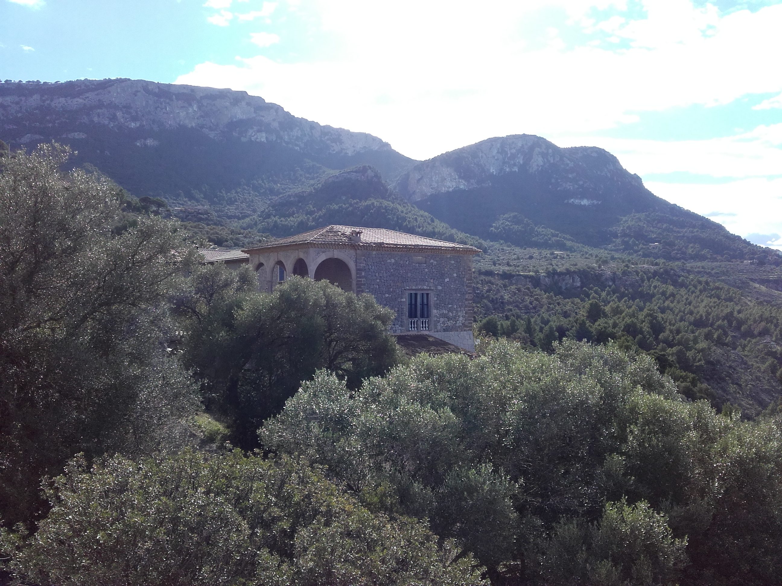
Featured photograph: Son Marroig, Serra de Tramuntana near Valldemossa, photographed by Rafael Ortega Díaz (Rafax), 24 November 2015. CC BY-SA 4.0, via Wikimedia Commons. Original used unchanged; the image is archival and not evidence of current access.

- UNESCO — Cultural Landscape of the Serra de Tramuntana
- UNESCO — Talayotic Menorca
- UNESCO — Ibiza, Biodiversity and Culture
- Illes Balears Tourism — official destination portal
- Spain DGT — 2026 Formentor lighthouse access regulations
- Menorca Council — Naveta des Tudons and protection rules
- Balearic Islands Government — s’Albufera des Grau Natural Park
- Formentera Tourism — beaches, routes and sustainable tourism
- Ibiza Tourism — official visitor and cultural information
- Spanish National Parks — Cabrera navigation permits and restrictions
- Spain Tourism — Balearic Islands travel context