
Where should you go in the Galápagos Islands? Start on Santa Cruz with Puerto Ayora and the Charles Darwin Research Station, see giant tortoises in the highlands and follow the signed path to Tortuga Bay. Bartolomé gives one of the archipelago’s most distinctive volcanic viewpoints, North Seymour is known for seabirds, and Española’s Punta Suárez for dramatic wildlife. Isabela, Fernandina and San Cristóbal add entirely different natural and human histories. The challenge is choosing an itinerary that respects the real boat connections, not collecting ten names in one weekend.
The Galápagos are an Ecuadorian archipelago in the Pacific with a UNESCO-listed natural World Heritage property and an exceptionally important national park and marine reserve. Its ecosystems are renowned for endemic species, but visiting them is not an invitation to feed wildlife, cross nesting areas or step wherever a photographer found a view. Most protected visitor sites require an authorised Galápagos National Park naturalist guide and permitted operator. Some public town and beach routes have different access arrangements.
Before travelling: Ecuador’s Galápagos Government Council administers a Transit Control Card, and the National Park charges an entrance fee under its current rules. You must also follow biosecurity inspection and baggage requirements designed to keep introduced organisms from reaching the islands. Do not assume a booking for a hotel covers island entry, park admission or guided visitor sites. The National Park Directorate’s rules require staying on marked trails, keeping at least two metres from wildlife and avoiding flash photography of animals.
2026 park, wildlife and arrival rules
The Ecuadorian Galápagos National Park and the Galápagos Government Council impose different visitor, fee and transit-card requirements. At protected areas, use an authorised naturalist guide, stay on marked paths and keep at least two metres from wildlife. Check the exact site and present regulations before booking.
eduKate · World travel and learning
Find your Galápagos reading route
Three geographic chapters and ten distinct experiences, selected for ecology, history and practical access.
ROUTE 1 · PLACES 1–3
Santa Cruz: research, tortoises and beach
Read each place and continue through the guide.
ROUTE 2 · PLACES 4–6
Bartolomé, North Seymour and Española wildlife voyages
Read each place and continue through the guide.
ROUTE 3 · PLACES 7–10
Isabela, Fernandina and San Cristóbal
Read each place and continue through the guide.
Ten places to understand the Galápagos
Different islands provide distinct wildlife, geological and human histories. They cannot all be visited as day trips from a single harbour.
| Place | Why choose it? |
|---|---|
| 1. Puerto Ayora and the Charles Darwin Research Station, Santa Cruz | Start with scientists, conservation work and a living island town. |
| 2. Santa Cruz highlands, El Chato and Los Gemelos | Compare free-ranging giant tortoises, mist forest and collapsed volcanic pits. |
| 3. Tortuga Bay, Santa Cruz | Discover two contrasting beaches and why calm-looking water is not a safety certificate. |
| 4. Bartolomé Island viewpoint and Pinnacle Rock | Read volcanic geology while protecting rare penguin and turtle habitats. |
| 5. North Seymour Island and its seabird nesting trails | Observe frigatebirds, blue-footed boobies and land iguanas without disturbing them. |
| 6. Española Island: Punta Suárez and Gardner Bay | Explore coastal bird colonies while respecting seasonal seabird migrations. |
| 7. Puerto Villamil and the Wall of Tears, Isabela | Understand island community life and the difficult history of a penal colony. |
| 8. Sierra Negra volcano, Isabela Island | See a vast volcanic caldera through a demanding, managed highland trail. |
| 9. Fernandina Island: Punta Espinoza | See a young volcanic island and remarkable marine-iguana habitats. |
| 10. San Cristóbal: Puerto Baquerizo Moreno and Kicker Rock | Combine a living provincial capital with a dramatic offshore marine landmark. |
1. Puerto Ayora and the Charles Darwin Research Station, Santa Cruz
Why this place deserves time. Puerto Ayora is a working centre of Galápagos tourism, public services, research and transport. Along its waterfront, visitors can see the practical links among fishing, small-boat travel and environmental management. The Charles Darwin Research Station is particularly important because it brings the archipelago’s biological research and conservation programmes into view. Giant-tortoise breeding and restoration have been part of this long effort, but individual exhibits, animal viewing and permitted access change according to programme needs.
What to notice. Walk public streets and authorised waterfront areas without blocking fishing crews or boating operations. At a research or interpretation facility, read signs to distinguish wild animals, animals in conservation care and historical exhibits. A close photograph of one tortoise does not establish how a population is doing; researchers need long-term information about survival, habitat and breeding. Listen to local guides and reserve time for exhibitions rather than treating research as a stop for a selfie.
The learning question. Ask how a scientist tests whether a conservation action has worked. Compare measuring the health of one animal with studying a population across years. A second question is how a populated town manages boat movements, waste and water without damaging the habitat on which its economy depends. Puerto Ayora makes visible the connection between everyday community life and protected-area rules.
Access and planning
Check the Darwin Foundation’s current public interpretation hours and procedures. The Foundation is a research organisation, not a zoo promising continuous access to every programme. Use authorised operators for national-park outings, and leave time to purchase or confirm transport, park fees and island biosecurity procedures.
2. Santa Cruz highlands, El Chato and Los Gemelos
Why this place deserves time. Santa Cruz’s highlands show an environmental contrast that beach photographs cannot capture. The transition from dry coastal vegetation to misty higher ground supports different plant communities, including places where giant tortoises roam through pastures and protected habitat. El Chato is associated with tortoise observations, while Los Gemelos consists of two impressive pit craters related to collapse into subsurface volcanic structures. Galápagos Conservancy describes the area as a useful place to understand changes in altitude, geology and ecological zones.
What to notice. From approved paths on authorised properties, watch tortoises moving through vegetation without touching, feeding or approaching them. Private farms and reserves have separate admission rules. At Los Gemelos, observe the deep depressions and surrounding Scalesia woodland from safe signed routes. Do not climb beyond crater railings or claim that every hole was made by a conventional explosive volcanic eruption; the collapse interpretation matters.
The learning question. Sketch the difference between a tall volcanic cone and a collapse pit, then ask which processes can create each form. Compare humid forest plants with those on lower dry coast and examine how tortoise behaviour fits the habitat. Conservation questions require repeated scientific monitoring, not a single encounter with a photogenic animal.
Access and planning
Arrange appropriate local transport and access to the chosen farm or reserve, confirming permits and opening. Mist and rain can make forest surfaces muddy. Keep at least the park-recommended distance from animals, and never step into pasture without permission. A half-day highland experience pairs naturally with a town-based programme.
3. Tortuga Bay, Santa Cruz
Why this place deserves time. Tortuga Bay is reachable by a walking route from Puerto Ayora and illustrates the important distinction between protected visitor access and swimming safety. Galápagos Conservancy describes the long exposed outer beach as subject to strong undercurrents, with a more sheltered inner beach nearby. Even where a public beach route does not require a naturalist guide, it still belongs to an exceptionally sensitive island ecosystem. Marine iguanas, birds and other wildlife should be observed without interference.
What to notice. Follow the marked approach through the dry vegetation zone, noticing changes in plants and shore habitat. On reaching the beach, compare open-wave exposure with the more sheltered inner bay. A quiet-looking surf line does not mean a person can safely swim, and local conditions can change. Do not enter wildlife nesting or resting areas for a photograph, and leave shells, plants and stones where they are.
The learning question. Draw two shoreline profiles, one open to the ocean and one sheltered. Ask how the coastline influences wave and current exposure, and why two beaches minutes apart can need different visitor precautions. A second question explores the relationship between town development and the footpath created to concentrate visitor traffic.
Access and planning
Check the park’s current trail opening and authorised activities for each beach. The walk can be long and hot; carry drinking water, sun protection and suitable shoes. Do not assume swimming is permitted or safe along the exposed beach. Respect all guides, rangers and signs despite the route being accessible from town.
4. Bartolomé Island viewpoint and Pinnacle Rock
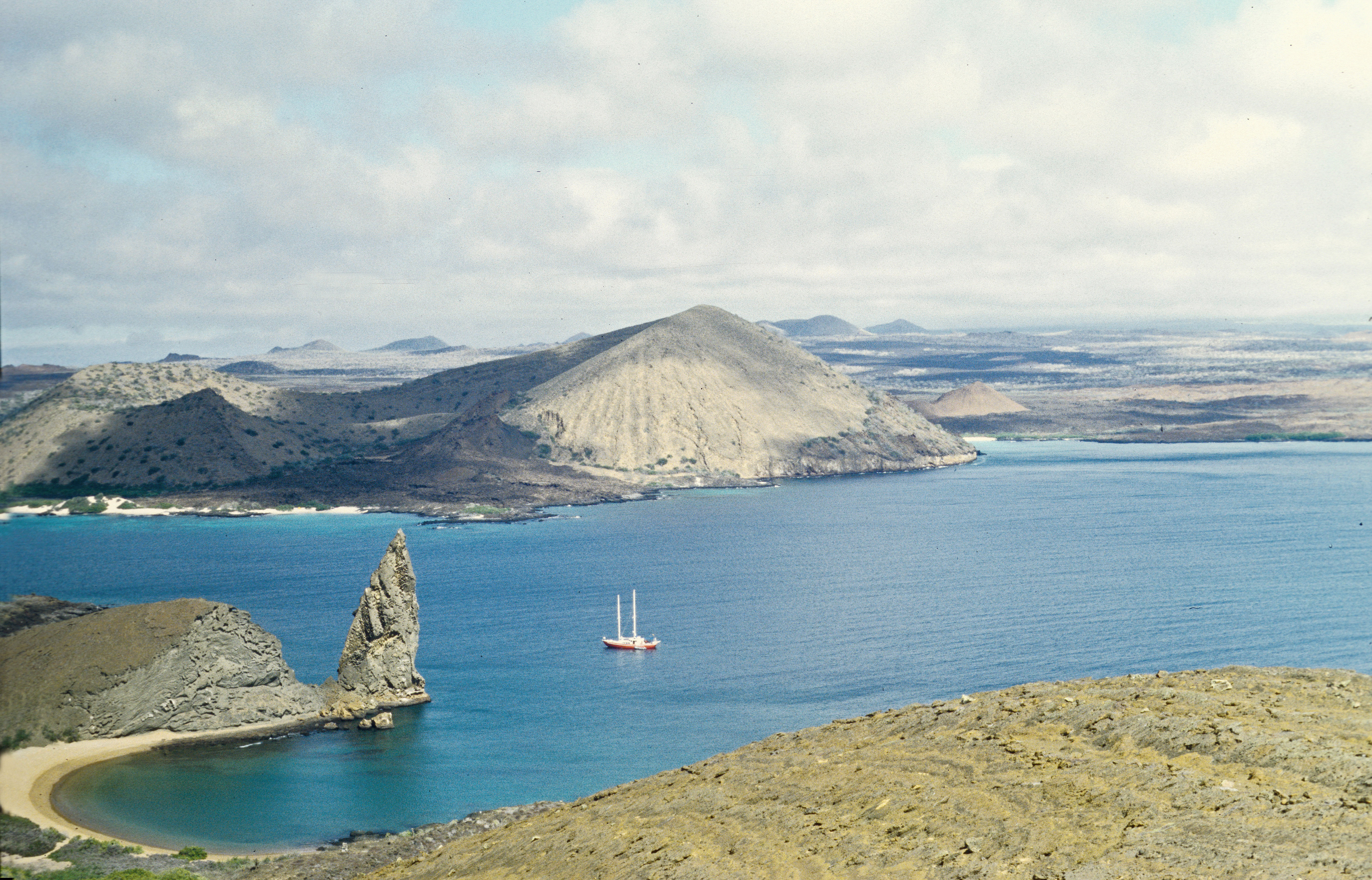
Why this place deserves time. Bartolomé is famous for its panoramic view over Pinnacle Rock and the surrounding volcanic islands. The Galápagos Conservancy describes a roughly 600-metre walkway with a staircase leading up to a hilltop viewpoint, providing a clear look at tuff and lava forms. The island has sensitive wildlife habitats, including areas used by Galápagos penguins and nesting turtles. A managed excursion is valuable because visitors can see both a visually remarkable volcanic landscape and the direct conservation measures used to protect it.
What to notice. From the established viewpoint, compare the pointed rock with the shape of surrounding cones and dark lava. The staircase itself concentrates foot traffic to limit erosion, which deserves attention as part of the visit. From lawful shore areas, look for marine animals without expecting a species to be present on schedule. The southern beach has separate restrictions, including no swimming as described in the official conservation visitor guide.
The learning question. Ask how volcanic material interacting with seawater can produce distinctive forms and why geological explanation requires more than appearance. Then compare a boardwalk protecting fragile volcanic terrain with marine protections preventing disturbance of nesting areas. A scientific field note can distinguish observed rock shapes from hypotheses about eruption dates.
Access and planning
Bartolomé is typically reached by a licensed boat excursion with an authorised naturalist guide. Confirm landing, the actual visitor route, stair access, weather and any marine activity separately. The island’s delicate volcanic terrain and habitats do not allow self-directed wandering or informal boat landings.
5. North Seymour Island and its seabird nesting trails
Why this place deserves time. North Seymour is a comparatively low island known for seabird breeding activity and land iguanas. The Galápagos Conservancy describes both shorter and longer visitor trail options through a habitat where magnificent frigatebirds, blue-footed boobies and other birds can be observed at certain times. Animal behaviour is the reason to visit, but wildlife remains wild and no particular courtship display or nest is guaranteed. The island’s history of conservation includes the movement of land iguanas from Baltra when introduced animals threatened their habitat.
What to notice. Stay on the marked loop and observe the relationship between nesting birds, exposed ground and shoreline. Avoid walking around an animal to obtain a closer photograph. An iguana crossing the path is a reason to pause, not to chase it away. Read guide interpretation about the difference between a bird’s breeding display and ordinary movement without attempting to provoke either.
The learning question. Ask how introduced mammals and vegetation changes can alter the survival of a native species. The island’s translocation history offers a real example of conservation decisions involving risk and monitoring. A second exercise compares observations of two bird species without assuming the abundance visible on one day represents the long-term population.
Access and planning
Use a licensed tour vessel and Galápagos National Park-authorised naturalist guide. Strict marked-route and wildlife-distance rules apply. Be prepared for uneven rock, heat and an exposed landing. The route can close or be modified because of wildlife management or sea conditions.
6. Española Island: Punta Suárez and Gardner Bay
Why this place deserves time. Española is one of the archipelago’s most important seabird destinations. Punta Suárez is associated with nesting colonies of blue-footed and Nazca boobies, marine iguanas and waved albatrosses in their breeding season. The Galápagos Conservancy notes that most of the world’s waved albatrosses breed here, but their presence is seasonal; an October visit is not the same as a February itinerary. Gardner Bay offers a separate sandy-shore environment where sea lions may be encountered under appropriate visitor controls.
What to notice. From the authorised Punta Suárez trail, look at how birds use cliff, vegetation and exposed rock. Nesting birds can be extremely close to the path, which increases the importance of keeping to it. At Gardner Bay, compare sandy shore habitat and marine wildlife with the rocky trail. Never step around a barrier to approach a bird or sea lion, and do not use flash photography.
The learning question. Ask why a seabird can travel immense distances at sea yet return to a particular island to reproduce. What long-term records would scientists need to track a breeding colony? Contrast the natural history of Española’s exposed cliffs with the volcanic viewpoint on Bartolomé. The value lies in habitat differences, not only in a longer wildlife species list.
Access and planning
Española requires a licensed boat itinerary with approved sites and guide. Choose a route according to the species and habitats you wish to understand, without assuming that every tour visits both Punta Suárez and Gardner Bay. Water and trail access are weather-dependent and can be subject to conservation changes.
7. Puerto Villamil and the Wall of Tears, Isabela
Why this place deserves time. Puerto Villamil is an inhabited settlement on Isabela, the largest Galápagos island, and a useful base for understanding local fisheries, transport and the relationship between modern island residents and protected habitat. The Wall of Tears lies inland from town and was built by prisoners during the twentieth-century penal colony period. Its significance is historical and ethical, not merely architectural. A careful visit must address the forced labour and suffering associated with the wall rather than using it as a decorative backdrop to a bicycle tour.
What to notice. Compare the shape of the low coastal settlement with the sandy tracks and dry vegetation toward the wall. Read official interpretation and ask which parts of the wall were created by forced labour and what is known from records or testimony. Along the route, wildlife may be visible without guaranteeing any particular encounter. Respect the site as a place connected with trauma and avoid climbing or removing loose stones.
The learning question. Ask how the island’s remoteness affected the penal colony and why governments in different eras used isolation as a form of control. Pair the history with geography by mapping access to water, food and the coast. A more complete lesson compares the experiences of incarcerated people with modern conservation and community life.
Access and planning
Check current park routes, local transport permissions and guide requirements for the Wall of Tears rather than assuming every tour or bike hire covers it. Wear sun protection and bring water. Keep to approved paths and maintain the appropriate distance from wildlife. Isabela is reached through separate boat or air arrangements from other islands.
8. Sierra Negra volcano, Isabela Island
Why this place deserves time. Sierra Negra is a major active volcanic landscape on Isabela with an immense summit caldera and dramatic changes in vegetation and elevation. It is distinct from the collapse pits of Los Gemelos or the smaller volcanic formations on Bartolomé. A guided hike can help visitors observe the shape of the rim and the results of volcanic activity, but conditions change through weather, management and geological risk. It should not be presented as an easy walk or a summit that must be reached to appreciate the archipelago.
What to notice. On an authorised trail, observe changing vegetation, volcanic rock and the caldera’s vast scale from safe approved viewpoints. Cloud or heavy rain can conceal the rim and create dangerous footing. A fresh-looking lava field does not prove a specific eruption date without scientific information. Stay back from unprotected edges and follow guidance about restricted areas.
The learning question. Create a side-by-side comparison of Sierra Negra, Bartolomé and Los Gemelos. Their different forms can help explain why the word ‘crater’ is not a complete geological description. Ask what monitoring volcanologists need to decide whether a route is safe. A good explanation states which conclusions depend on measurements rather than photographs.
Access and planning
Arrange an approved Galápagos naturalist guide and check the current site opening, permit conditions, fitness demands and weather. Prepare for a substantial hike with water and suitable shoes, and avoid self-guided access to closed volcanic routes. An alternative Isabela cultural or wildlife activity is appropriate if the highland trail is unsuitable.
9. Fernandina Island: Punta Espinoza
Why this place deserves time. Fernandina is among the least altered and most volcanically active islands in the Galápagos, and Punta Espinoza is an especially instructive visitor site. Its volcanic rock shores host marine iguanas and other organisms adapted to a highly exposed landscape. A western-island excursion here is fundamentally different from a town-based Santa Cruz day. The attraction is a protected natural system that helps explain adaptation, geology and research; it is not a promise that a visitor may walk onto any black lava shore.
What to notice. From a marked authorised trail, compare twisted volcanic rock and coastal vegetation. Watch marine iguanas basking or moving without chasing or crowding them, and keep appropriate distance even when an animal appears unafraid. Marine birds and sea lions may be seen at certain times, but they are not a scheduled performance. Do not enter lava crevices or touch fragile organisms.
The learning question. Ask how marine iguanas differ from most terrestrial lizards in their feeding and relationship to coastal water. Compare new or sparsely vegetated volcanic rock with the lush Santa Cruz highlands. Repeated scientific studies are needed to measure how the island responds to eruptions and ocean conditions, not one afternoon’s observations.
Access and planning
Punta Espinoza is accessed only through suitable licensed western-island itineraries and authorised guides, with entry affected by volcanic activity and National Park decisions. Do not assume a day trip from Puerto Ayora is realistic. Book through responsible licensed providers and accept changes when sea or geological safety requires them.
10. San Cristóbal: Puerto Baquerizo Moreno and Kicker Rock
Why this place deserves time. San Cristóbal has a different everyday rhythm from Santa Cruz and Isabela, and its town Puerto Baquerizo Moreno is the capital of Galápagos Province. Its public waterfront, conservation interpretation and transport activity introduce a community whose life is closely connected with the sea. Offshore Kicker Rock, locally León Dormido, is a striking eroded volcanic formation visited on authorised boat excursions. Pairing the two makes clear the difference between walking in a town and entering a marine visitor site controlled for wildlife and navigational safety.
What to notice. In town, observe public spaces and how the waterfront is shared among boats, people and animals. Offshore, look at the twin-sided volcanic rock and exposed sea from an approved vessel, paying attention to conditions rather than assuming a photo can show underwater currents. Where authorised snorkelling or diving is available, avoid touching marine animals and follow every guide instruction.
The learning question. Ask how marine erosion can change a volcanic landform and why different fish or seabirds use different habitats around it. Compare the requirements for a town walk, a boat viewpoint and an actual diving activity. The latter depends on competency and sea conditions rather than the attractiveness of the geology.
Access and planning
Arrange San Cristóbal transport separately from other islands, confirming actual ferry or domestic flight schedules and entry procedures. Kicker Rock requires a licensed operator, appropriate guiding, safety equipment and site-specific permission. A land-based cultural visit is a worthwhile alternative when sea conditions are unsafe.
Plan a thoughtful Galápagos journey
Get the correct island documents and fees. Ecuador’s Galápagos Government Council administers the Transit Control Card (TCT); the National Park has a separate visitor entrance fee. Requirements and categories can change, so confirm both directly and prepare for baggage inspection and biosecurity controls before the island flight.
Distinguish guided visitor sites from town access. The National Park’s official rules require authorised naturalist guides at protected visitor sites. Some public town routes and beaches, such as designated portions of Tortuga Bay, have different visiting arrangements. Local signs and the site’s specific category take priority.
Choose island connections before tours. Santa Cruz and nearby excursions fit one cluster, while San Cristóbal and Isabela need separate travel time. Española, Fernandina and other remote islands often require specialised cruise itineraries. Do not copy a list of favourite sites as if ferries directly connected all of them.
Keep two metres from animals. Galápagos Conservancy reproduces the park’s wildlife-distance rule, alongside prohibitions on touching, feeding and flash photography. Animals may approach a path or beach; remain calm and let the guide manage the situation without stepping off the authorised route.
Protect biosecurity and sensitive habitats. Do not bring prohibited plants, seeds, soil or food; follow quarantine inspection and staff guidance. Some beaches have turtle nests, while others have dangerous surf. Do not walk across dunes or wildlife areas just for a closer image.
Use responsible, licensed operators. Park sites have permitted activities, landing rules and limits. An underwater excursion, volcano hike and easy town walk require very different equipment and capabilities. A naturalist guide should interpret wildlife, not guarantee species encounters.
Preserve historical context. Puerto Villamil’s Wall of Tears reveals traumatic penal history, while modern Galápagos communities have their own livelihoods and perspectives. Protect marine and terrestrial nature while acknowledging people who live and work in the archipelago.
Frequently asked questions
Do I need a naturalist guide to visit the Galápagos?
At protected visitor sites in the national park, an authorised naturalist guide is required. Certain public town and designated beach routes have different rules. Follow the Directorate’s site-specific access conditions.
Is a Transit Control Card the same as a National Park entrance ticket?
No. The Galápagos Government Council administers a Transit Control Card, and the National Park has its own fee and visitor requirements. Check current amounts and application procedures.
Can I touch a giant tortoise if it comes close?
No. The official park rules require at least a two-metre distance from wildlife and prohibit touching or feeding. Let a guide manage any unexpected close animal approach.
Is Tortuga Bay always safe for swimming?
No. Galápagos Conservancy cautions about strong undercurrents at the exposed outer beach. A separate inner area has different conditions, and local guidance must be followed on the day.
Are all ten locations reachable on day trips from Santa Cruz?
No. Isabela and San Cristóbal require inter-island planning, and remote islands such as Fernandina or Española may appear only on suitable licensed vessel itineraries.
What makes Bartolomé Island different?
Its striking volcanic forms, particularly Pinnacle Rock, are visible from a managed viewpoint. The island also has specially protected penguin and turtle habitats that require respectful access.
Why are the Galápagos a World Heritage Site?
UNESCO recognises the archipelago for its exceptional volcanic and island ecosystems, endemic life and influence on understanding biological evolution. The inscription does not override National Park visitor restrictions.
Learn how evidence shapes the experience
A Galápagos field journal can compare four kinds of evidence: living community history in Puerto Ayora, ecological research on Santa Cruz, volcanic geology on Bartolomé and Sierra Negra, and wildlife conservation on Española and Fernandina. The most useful visitor understands that a photograph is one observation, while science depends on repeated records and protected access. The right itinerary respects both the natural environment and the people who manage it.
For an educational activity, trace Santa Cruz, Isabela and Española on a map, then identify why boat routes, conservation permissions and sea conditions matter more than straight-line distance. Show the assumptions rather than guessing transport time. This is the same evidence-first approach encouraged in eduKate’s Secondary 1 Mathematics Tutor Clementi | Small Groups Tutorials.
Continue learning about the Galápagos
Top 10 Things to Do When Visiting and Touring Galápagos Islands · Top 10 Things to Learn When Visiting and Touring the Galápagos Islands · World Country Directory
Sources, current advice and image credit
Official park and conservation resources checked on 20 October 2026 (Singapore time). They are a source of park rules and ecological background but cannot guarantee today’s opening, wildlife sightings or sea conditions. Reconfirm entrance requirements, biosecurity inspection, guide certification and permitted activities on the chosen dates.
Featured photograph: Bartolomé Island and Pinnacle Rock, Galápagos, scanned from a photograph made in August 2002 by Cayambe. CC BY-SA 3.0, via Wikimedia Commons. The original image was reused unchanged; it is archival rather than evidence of current park access.

- Ecuador — Galápagos National Park official visitors page
- Ecuador — National Park authorised visitor sites
- Galápagos Government Council — Transit Control Card procedure
- Galápagos Conservancy — National Park rules
- Galápagos Conservancy — Santa Cruz sites and Tortuga Bay
- Galápagos Conservancy — Bartolomé visitor information
- Galápagos Conservancy — North Seymour conservation and visits
- Galápagos Conservancy — Española island and seasonal albatrosses
- Galápagos Conservancy — all island guides
- UNESCO — Galápagos Islands World Heritage property
- Charles Darwin Foundation — Galápagos research