
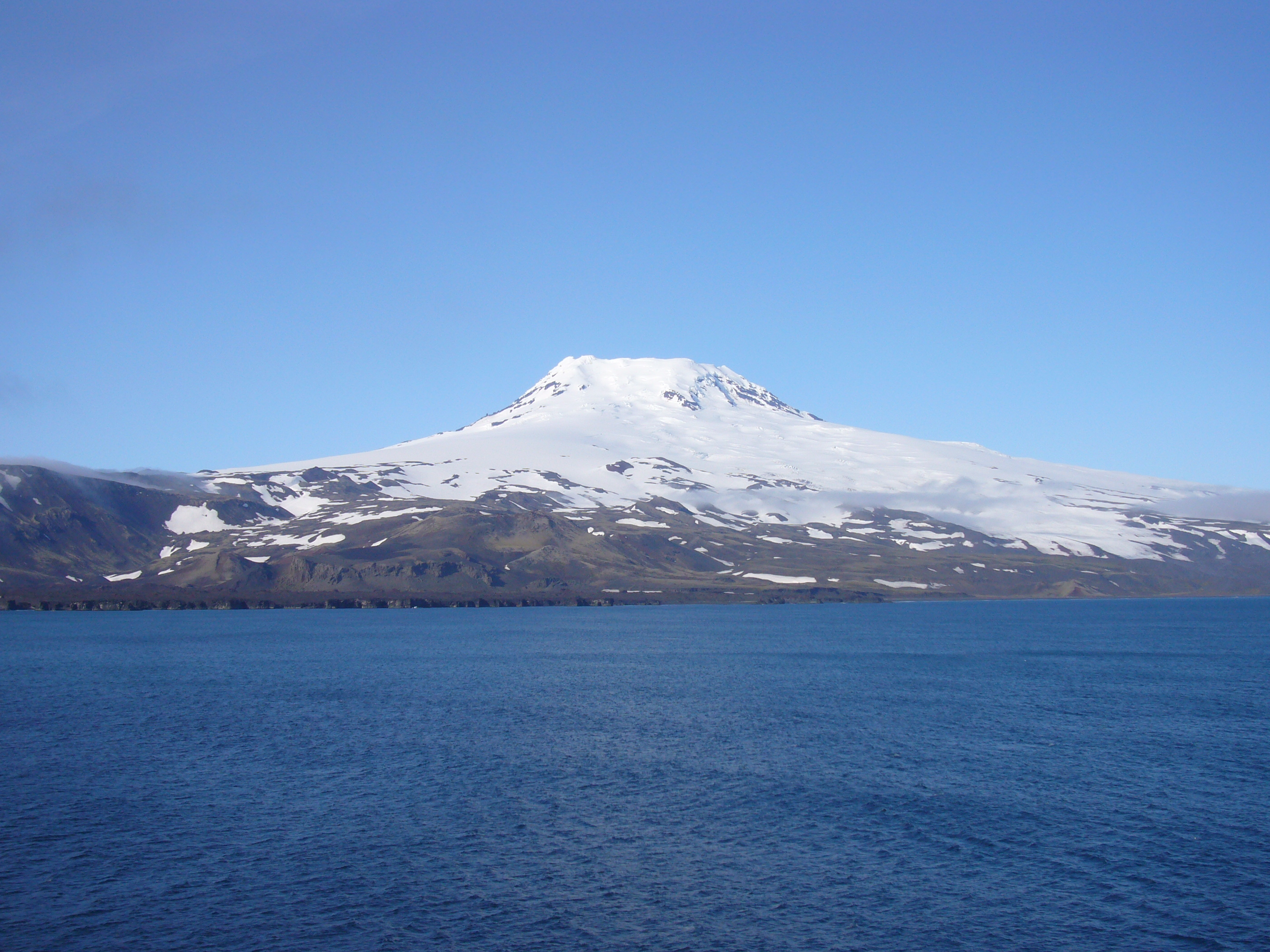
Jan Mayen is a remote Norwegian Arctic island famous for Beerenberg, a glacier-covered active volcano. It has a working weather and communications station, important seabird habitats and remains of centuries-old whaling activities. It is not a conventional visitor island with hotels or a port. The ten places below are geographical, ecological and historical subjects to understand, while only a very limited short visit may be possible through official prior permission.
October 2026 caution: Jan Mayen’s station reports that extensive construction from summer 2025 through winter 2027–28 restricts vessel arrivals and island access. The station requires an application for any landing, and foreign vessels also need separate clearance for entry into Norwegian territorial waters. Even an approved ship call can be cancelled for weather, lack of capacity or safety. Do not book a ‘ten-stop Jan Mayen tour’ because such a product would misrepresent actual access.
The island is an Arctic nature reserve, with exceptions for small operational areas near Olonkinbyen, the airstrip, Kvalrossbukta and a defined bay. Most of the famous landforms and bird habitats are protected and not open for ordinary independent exploration. This article therefore explains why ten different places matter, distinguishing the normal landing point, working scientific infrastructure and protected sites that should be studied remotely.
eduKate · Arctic volcanoes, working science and conservation
Jan Mayen is not a typical sightseeing island
Ten places explained · Official landing area · Volcano and glaciers · Whaling archaeology · Seabird reserve · Permits and current restrictions
No public hotels, no scheduled ferry and restricted island access during 2025–28 construction. Confirm authorisation with the station before planning any voyage.
Ten Jan Mayen places at a glance
Only Kvalrossbukta is a normally designated visitor landing area, subject to advance approval and suitable conditions. The other locations are chiefly working or protected natural and historical sites, not stops that can be visited at will. This comparison makes their significance clear without suggesting unlawful access.
| Place | What it teaches | Present access limitation |
|---|---|---|
| 1. Kvalrossbukta, the only normal visitor landing area | A storm-exposed bay at the heart of Jan Mayen’s visitor permissions | Pre-authorised landing; construction restrictions and surf |
| 2. Olonkinbyen, the island’s principal staffed station | Meteorology, communications and everyday work on a remote Arctic island | Operational base; not a tourist accommodation centre |
| 3. Båtvika and the southeastern station coastline | An Atlantic landing environment linked with station operations | Restricted shoreline; working infrastructure and marine reserve boundaries |
| 4. Beerenberg volcano and the northern mountain massif | A glacier-covered active Arctic volcano | Nature reserve: no independent summit expeditions |
| 5. Weyprecht Glacier and the ice-clad northern coast | Glaciers shaped by a volcano and northern ocean climate | No ordinary glacier walk or landing in the protected area |
| 6. Nordlaguna, the freshwater lagoon near northern Jan Mayen | An isolated lake system and sensitive Arctic freshwater habitat | Protected reserve; no independent entry or boating |
| 7. Eggøya volcanic crater and southeastern landforms | Historic eruptions and a landscape of lava and tuff | Protected ground; no routine crater walks |
| 8. Kvalrossbukta whaling archaeology and Kvalrossen hillside | Remnants of early Dutch Arctic whaling and winter survival | Do not touch historic material or climb unstable remains |
| 9. Sør-Jan’s lower volcanic ridges and land bridge | A southern relief system distinct from Beerenberg | Protected reserve with restricted independent movement |
| 10. Jan Mayen seabird cliffs and the protected surrounding sea | An internationally valuable nesting habitat without normal visitor landings | Seasonal bird-cliff restrictions and mandatory safe distances |
1. Kvalrossbukta, the only normal visitor landing area
What makes it significant: Kvalrossbukta on Jan Mayen’s west coast is the most important place for a would-be visitor to understand because it is the island’s designated landing area. The beach is not a sheltered port with a ferry pier, café and public bus stop. Ships anchor offshore when circumstances allow, and passengers may be transferred in small boats through surf. The landscape can look calm in one photograph and be impossible to reach on another day. The first lesson is therefore the distinction between seeing an island from a ship, obtaining permission to enter Norwegian waters and being permitted to land.
Geography or history: The name Kvalrossbukta means a bay associated with walruses, though the area’s more substantial human heritage involves seventeenth-century whalers and later Norwegian station activity. A protected-area boundary leaves a limited activity zone around the landing site, while most of the island remains within Jan Mayen Nature Reserve. That boundary should not be interpreted as open public access to the whole coastline. The geography of the bay explains why ship-to-shore operations are challenging: there is no fully sheltered harbour, and wind, wave direction and surf can change more quickly than a scheduled tourist plan.
Realistic access: The island station’s current guidance requires foreign vessels to apply for territorial-water entry and every visiting boat to coordinate a landing with the station commander. Because of major construction from 2025 until winter 2027–28, arrivals and access are further restricted in 2026. Anyone arranging a voyage must contact the station well beforehand and accept cancellation even after approval. There are no public bathrooms, medical facilities or guaranteed transport on shore. Passengers must stay in permitted areas, obey the shore team’s briefing and not approach equipment or historical remains independently.
Learning question: Draw a map with an offshore vessel, the Kvalrossbukta shoreline and the inland road toward the station. Label which stage depends on weather, which on government permission and which on safe local landing capacity. Why is a ship being nearby not enough to guarantee an island visit?
Back to ten-place index · Next place
2. Olonkinbyen, the island’s principal staffed station
What makes it significant: Olonkinbyen is the island’s principal staffed station, situated near the southeastern coast. Its buildings, communications equipment and associated support facilities demonstrate how a small group of workers sustains research and government-related operations through difficult Arctic seasons. The station is not a village with ordinary tourist services or a hotel open to anyone who arrives. Its value as a place to study lies in the essential functions performed there: observing weather, maintaining equipment and coordinating safe activity.
Geography or history: Norwegian personnel have maintained a meteorological and communications presence on Jan Mayen for decades. Weather observations made far from major landmasses help forecasters understand atmospheric conditions across the North Atlantic and Arctic. A station also needs housing, power, supplies, communications and reliable maintenance. The history of radio navigation and modern instruments shows changing technology, but a photograph of an antenna cannot tell which system is active or when it was installed. Protected nature-reserve land lies close by, so even operational work must consider the risk of introducing organisms or damaging sensitive terrain.
Realistic access: Do not assume that successful landing grants admission to Olonkinbyen’s rooms, workshops, residences or scientific equipment. The station has no obligation to provide visitor accommodation, meals or transport and must prioritise its own work. Construction creates additional restricted and potentially hazardous areas in 2026. The road from Kvalrossbukta is approximately nine kilometres and may be closed between November and May according to station guidance. A short tourist stop is not an invitation to walk that route unescorted in difficult weather. Ask for current staff directions and remain within the approved programme.
Learning question: List the systems that a year-round weather station needs: energy, shelter, instruments, data transfer, transport and safety. Which are visible in an aerial image, and which would require a technical account to understand?
Back to ten-place index · Next place
3. Båtvika and the southeastern station coastline
What makes it significant: Båtvika is associated with the southeastern side of Jan Mayen and the station-area infrastructure. It gives a different geographical view of the island from Kvalrossbukta, particularly in the relationship between coastal land, buildings and the open sea. Yet it should not be advertised as a second public visitor beach. Much of this area is part of the active station environment, and a narrow exception in the adjacent protected marine reserve exists to serve operations rather than tourism.
Geography or history: The official nature-reserve regulation distinguishes the protected land from the activity area around Olonkinbyen and the airport, as well as the Kvalrossbukta landing zone. It also excludes a defined water area around Båtvika from the wider reserve boundary. These precise exceptions are important because protected land management depends on maps and legal definitions. A visitor who sees an open-looking beach should not assume a right to camp, launch a boat or explore station facilities. Coastal erosion, storm waves and supply operations may further limit where people can stand safely.
Realistic access: Båtvika is best regarded as a subject for map-based learning or a station-authorised observation, not a normal stop on a tourist itinerary. Do not attempt to land there from a privately arranged dinghy without the necessary clearances. Respect all station security and construction signage. The island’s travel guidance stresses that anchoring and small-boat activity in Norwegian territorial waters are regulated. A permit to approach the island does not override nature-reserve or operational rules. When conditions do not allow a safe view, official charts and photographs provide the safer alternative.
Learning question: Use an authorised map to compare Båtvika and Kvalrossbukta. Why might two bays on the same island differ in wave exposure, permitted activity and infrastructure? Separate geographical observations from legal rules.
Back to ten-place index · Next place
4. Beerenberg volcano and the northern mountain massif
What makes it significant: Beerenberg dominates the northern end of Jan Mayen, rising to around 2,277 metres and often wearing a thick cap of cloud. It is widely described as the world’s northernmost active volcano above sea level. For a visitor travelling on a permitted ship, an occasional clear view of the mountain can be unforgettable. But its greatness is not measured by whether a tourist reaches the crater. The mountain is within a protected nature reserve, and the environmental and rescue challenges make spontaneous climbing inappropriate.
Geography or history: The Norwegian Polar Institute describes Beerenberg as a composite volcanic system with lava and fragmented eruptive deposits, over twenty glaciers and a documented eruption in 1985. Scientists study its rocks, surface changes and the relationship between volcanic activity and ice. The dramatic cone is evidence of volcanic construction, but its present outline alone cannot establish exactly when every eruption occurred. Cloud and glaciers conceal much of the surface from ordinary observation. The mountain also forms part of a landscape critical to seabirds and Arctic ecological research, so geology and conservation belong in the same description.
Realistic access: The island’s nature-reserve law restricts landing, camping and many forms of travel, while the station’s current visitor policy requires prior permission even for normal short visits. Do not promise a Beerenberg summit climb, a helicopter landing or an independent crater tour. Special scientific expeditions have separate permitting requirements. Weather can change rapidly, rescue cannot be expected, and there is no tourist accommodation or guided climbing industry available on demand. The responsible public experience is to observe from a safe approved area or study maps and verified scientific imagery.
Learning question: Draw an idealised composite volcano with a crater, lava layers and a glacier. Explain which layers are visible in a photograph and what a geologist must measure to reconstruct the eruption history.
Back to ten-place index · Next place
5. Weyprecht Glacier and the ice-clad northern coast
What makes it significant: Weyprecht Glacier is among the glaciers descending from Beerenberg and offers an excellent study of the interaction between ice and volcanic topography. When skies are clear, ice moving down mountain valleys can become visible from a suitable offshore viewpoint. The glacier may appear motionless, but ice deforms and flows over time, and its fronts can change with snowfall, temperature and ocean conditions. This is not an ordinary tourism glacier where visitors can join a walk from a road.
Geography or history: The Norwegian Polar Institute reports that glaciers cover a substantial share of Jan Mayen’s landscape and that some glacier snouts have historically extended close to sea level. The relationship between volcanic slopes and glacier movement is complex: ice responds to gravity while crossing rock surfaces created by eruptions and erosion. A glacier’s appearance in one summer photograph cannot prove its rate of retreat. Repeat surveys, satellite data and field observations are required to distinguish short-term variation from persistent change. It is useful to compare ice imagery with the mountain’s broader geology rather than treat blue-white colour as the entire explanation.
Realistic access: Approach is governed by the ship’s safe navigation and the Norwegian reserve and territorial-water rules. Do not request an unapproved landing on glacier ice, or attempt to cross an area that looks solid from offshore. Ice fronts can calve and smaller bergs may create a navigational danger. Protect seabird concentrations from vessel noise and inappropriate proximity. If fog or ice prevents an approach, a Norwegian Polar Institute map is a legitimate learning substitute. Photography should not be presented as an actual scientific measurement without supporting dates and coordinates.
Learning question: Choose two dated photographs of the same glacier taken from comparable angles. Note which visible changes could result from season or camera position, and outline what repeat measurements would establish a longer-term trend.
Back to ten-place index · Next place
6. Nordlaguna, the freshwater lagoon near northern Jan Mayen
What makes it significant: Nordlaguna is an important freshwater feature on an island otherwise defined by volcanoes, glaciers and marine exposure. Its existence introduces a useful contrast between inland water and the ocean around Jan Mayen. Lagoons and lake-like basins may respond to snowmelt, precipitation and coastal processes, so even a modest body of water can tell a complicated environmental story. Nordlaguna is worth learning about from an official map or scientifically documented photograph, not because a visitor can hire a canoe there.
Geography or history: Freshwater in a remote Arctic island may be limited and seasonally variable. The lake’s ecology can include microorganisms and organisms whose life cycles are influenced by freezing, thawing and local nutrient conditions. A protected nature reserve helps researchers observe such systems with less disturbance. The island’s current official visitor guidance notes that freshwater supplies for travellers are scarce, which is another reason not to imagine an independent camping holiday built around a mapped lake. Human access can introduce non-native organisms and pollutants that change a sensitive freshwater environment.
Realistic access: Nordlaguna lies within the protected nature-reserve landscape. Ordinary visitors should not attempt an independent hike from the landing area or carry watercraft there. The reserve law prohibits unapproved landing and many activities, and camping is limited to station employees and their guests under specified conditions. Leave lakeside plants, stones, bird habitats and historical features undisturbed. If a particular scientific visit is authorised, its conditions will be set by the relevant Norwegian authorities. For general readers, a topographic map and environmental account are the appropriate way to study the place.
Learning question: Make a small diagram of a coastal freshwater basin and label precipitation, snowmelt, evaporation and possible underground flow. Explain why a lake on an island surrounded by seawater is not automatically salty or safe to drink.
Back to ten-place index · Next place
7. Eggøya volcanic crater and southeastern landforms
What makes it significant: Eggøya is a distinctive volcanic feature toward Jan Mayen’s southeastern side and provides a geological contrast with the dominant cone of Beerenberg. The island is shaped by multiple phases of volcanism rather than one simple mountain-making event. Low-lying volcanic formations, cones and eruptive materials help visitors appreciate the diversity of landforms found within a narrow Arctic island. Its value comes through geology and research, not through encouraging an unprotected scramble across loose ash or rock.
Geography or history: A tuff cone forms from volcanic debris that can be strongly influenced by contact between erupting magma and water. The visible textures and slopes of Eggøya can be interpreted in this broader context, but exact dates and detailed sequences require geological studies. Weathering and erosion continue to alter volcanic surfaces long after an eruption. Vegetation may colonise some deposits while other areas remain sparse due to exposure, soil and age. The Norwegian Polar Institute describes Jan Mayen as a mosaic of basalt flows and fragmented volcanic material, which helps explain why different parts of the island look very different.
Realistic access: The protected reserve does not allow ordinary visitors to land wherever an interesting rock formation appears. The station’s construction period further limits tourist access. Do not advertise independent Eggøya hiking, rock collecting or a drone flight; restricted activities require permission or may be prohibited. An authorised shipboard view or a credible geological map is sufficient for learning. Be cautious about interpreting a volcanic photograph from another decade as evidence of today’s safe walking surface or route, especially after erosion or storms.
Learning question: Compare Beerenberg with Eggøya by making a two-column sketch of a high stratovolcano and a smaller tuff cone. Which differences could be identified from shape alone and which require examining rock material?
Back to ten-place index · Next place
8. Kvalrossbukta whaling archaeology and Kvalrossen hillside
What makes it significant: The seventeenth-century whaling landscape near Kvalrossbukta makes the landing area much more than a practical beach. A visitor looking from a designated point can study the relationship between a sheltered-enough working shore, high ground and the remains of industrial activity. The whalers’ presence was seasonal and required considerable logistical effort. Today the physical traces are limited and vulnerable to coastal erosion, which makes them particularly important to protect.
Geography or history: Norwegian historical scholarship records Dutch whaling operations on Jan Mayen from the early seventeenth century, with facilities for processing whale blubber near Kvalrossbukta. A tragic attempted overwintering in 1633–34 ended with the deaths of six whalers, whose diary helped preserve the record of the experience. Centuries of waves have removed or buried much of the built remains. Old iron anchors, cannons and other objects have been recovered and some displayed elsewhere on the island. These historical fragments tell stories of work, risk, international trade and the killing of whales, rather than presenting a harmless adventure camp.
Realistic access: The Kvalrossbukta activity zone does not mean archaeological objects are free to handle or collect. Visitors must follow approved routes and station instructions, especially during construction. Do not cross a conservation barrier to inspect a suspected wall or artefact. Loose volcanic material and eroding slopes can be unsafe in strong wind or rain. A historical account or photographs of recovered objects are the best supplements to a permitted distant view. The material belongs to an increasingly fragile Arctic cultural record that cannot be replaced if removed or broken.
Learning question: Record three questions about an old whaling site: why it was placed near this bay, how supplies arrived and what risks workers faced in winter. Which answers are geographical and which depend on documentary evidence?
Back to ten-place index · Next place
9. Sør-Jan’s lower volcanic ridges and land bridge
What makes it significant: Jan Mayen has a narrow central portion joining the much larger northern volcanic massif to southern ridges and lower volcanic terrain. Sør-Jan provides a perspective on the island’s complex origin that is easily missed when guides describe nothing but Beerenberg. The shape of the land also explains why the operational station and road have been established in certain places rather than simply along the highest peaks. Exploring this region intellectually through topographic mapping can reveal just as much as a physical hill climb would for many visitors.
Geography or history: Volcanic islands develop through successive lava flows, eruptions, erosion and, in Jan Mayen’s case, interactions with ice. Different parts of the island may belong to contrasting stages of growth. Low ridges and old eruptive cones show a record that requires geological mapping rather than a confident guess from their height. The reserve has significant wildlife and cultural value, including former trapping and meteorological sites. Even a road or weather station route across this landscape is primarily infrastructure for working personnel, not a public tourism pathway.
Realistic access: The protected-area rules restrict motor-vehicle use to station transport on recognised tracks and prohibit ordinary independent camping. A visitor landing at Kvalrossbukta cannot decide to spend a free afternoon traversing Sør-Jan. The station’s construction works make access restrictions even more important through winter 2027–28. If an authorised guide or staff visit is offered, follow the designated area and leave wildlife and old structures undisturbed. A Norwegian Polar Institute topographic map provides an appropriate and often safer alternative to physical travel.
Learning question: Compare the mapped heights and shapes of Sør-Jan and Beerenberg. Why can different volcanic landforms exist on the same narrow island, and what research would be needed to date them?
Back to ten-place index · Next place
10. Jan Mayen seabird cliffs and the protected surrounding sea
What makes it significant: The seabird colonies of Jan Mayen are among the strongest reasons for establishing the Jan Mayen Nature Reserve. Steep cliffs provide nesting habitat for birds that obtain food from the surrounding Arctic and North Atlantic seas. A vessel approaching the island may be able to see cliffs and birds without going ashore, but that does not make every coastal passage permissible. The value of a bird colony depends on the animals being able to breed and feed without disturbance, even when those same birds are the reason a traveller wants to visit.
Geography or history: SEAPOP and the Norwegian Polar Institute describe Jan Mayen as important to several seabird populations and to research on marine ecosystems. Birds travel across the sea to feed, linking conditions near the island with ocean productivity farther afield. Nesting cliffs can look densely populated in summer and nearly empty during another season. This difference does not by itself demonstrate population decline. Long-term monitoring is essential for interpreting changes. The nature reserve also conserves the sea floor, shore vegetation and historic cultural remains, giving its regulations a broader purpose than bird photography.
Realistic access: Norwegian nature-reserve regulations include strict restrictions around concentrations of birds and mammals from April through August, including a one-nautical-mile noise and aircraft caution. Ordinary landing in the reserve is prohibited unless specially allowed, and use of aircraft and other activity is regulated. Captains must follow territorial-water entry rules and avoid disturbance by boats or noise. Do not fly drones, use loud sounds to attract birds or approach nesting cliffs for a close photograph. Appropriate distant observation or official research imagery is sufficient for a learning experience.
Learning question: Sketch a cliff with nesting ledges and the surrounding sea. Explain how human noise or a boat approaching too closely might affect birds, and how scientists could monitor the colony without disturbing it.
Back to ten-place index · Permissions and planning
How to think about a Jan Mayen visit realistically
The first step is to understand that Jan Mayen is a Norwegian station and protected reserve, not a destination with scheduled tourist services. There is no commercial airport for civilian travellers, no normal port, no hotel, no visitor medical service and no public transport. A vessel must comply with Norwegian territorial-water regulations. Separately, the station commander must approve and coordinate any landing at the designated site. These are independent permissions; clearance for one does not imply the other.
The station’s guidance identifies construction lasting from 2025 through winter 2027–28 as a significant restriction on visitor access. A vessel may be refused because of limited capacity or safety conflicts even if weather is calm. The designated landing area is Kvalrossbukta, but getting passengers ashore can be challenging in swell. Visitors also need to recognise the approximately nine-kilometre road toward the main station, which can be closed during winter and is not a free public excursion route.
The island’s nature reserve protects almost all the land and surrounding sea. Ordinary visitors cannot disembark in reserve areas unless special authorisation is granted and may not independently camp or drive across protected ground. Seabird cliffs, glaciers, volcanic landforms and old whaling remains are all reasons to protect the island, not excuses for approaching without permission. Because fresh water, rescue options and medical facilities are minimal, the practical alternative for most curious readers is trustworthy remote learning through official photographs, station information and Norwegian Polar Institute maps.
Before contacting any ship operator
- Study the current Norwegian station visitor guidance, which explicitly warns that construction restricts access through winter 2027–28.
- Ask who will apply for clearance to enter Norwegian territorial waters and coordinate the separate landing application.
- Do not assume an approved application guarantees disembarkation; surf, weather or staff capacity may still prevent the visit.
- Plan for winter conditions and substantial fog, wind and swell at any time of the year.
- Do not advertise an independent Beerenberg climb, glacier trek or Eggøya landing: these are inside protected areas and require special authorisation.
- Expect no visitor hotel, normal scheduled taxi, public ferry or rescue capacity on the island.
- Keep footwear and clothing clean to protect the nature reserve against introduced organisms.
- Respect seabird nesting-season rules, quiet zones, protected whaling remains and all station-security barriers.
- Use Norwegian Polar Institute mapping for geological study instead of old commercial route maps that predate the current restrictions.
An approved short landing is not a ten-stop itinerary
A rare vessel visit might, with both sets of clearance and safe conditions, allow a limited time ashore at Kvalrossbukta. The ship’s personnel and station may then direct visitors to a small approved area or activity. The guests should not assume that they will have access to the meteorological base, the airstrip or a mountain trail. If the station has a construction conflict, the landing may be cancelled, and the journey may consist of offshore views only. A successful experience is one that keeps people and the reserve safe while providing reliable explanations of the island.
Frequently asked questions
Can tourists freely visit Jan Mayen in 2026?
No. The station requires advance coordination for every landing, and foreign vessels require separate clearance for territorial waters. Construction from 2025 through 2027–28 further restricts access.
Where can visitors normally land?
Kvalrossbukta is the designated visitor landing area, but weather and station permission determine whether a landing can occur.
Can I fly into Jan Mayen’s airstrip?
The island has a gravel airstrip for authorised operational aircraft. It is not a scheduled civilian airport or a normal way for tourists to arrive.
Is Mount Beerenberg active?
Yes. The Norwegian Polar Institute identifies a 1985 eruption and describes Beerenberg as an active volcano. Its protected nature-reserve status limits visitor access.
Can visitors climb or camp on Beerenberg?
Ordinary visitor permits do not authorise independent climbing or camping in the reserve. Any exceptional activity would require specific approval and substantial safety arrangements.
Does Jan Mayen have medical services for visiting travellers?
The station says it does not provide visitor medical services, accommodation or a dedicated rescue capability. Vessel organisers must plan for self-sufficiency.
Can I walk from Kvalrossbukta to Olonkinbyen?
Not on the assumption that the road is always public. It is about nine kilometres long, can close in winter and is affected by station operations and access restrictions.
What makes the island scientifically important?
Its active volcano, glaciers, seabird populations, isolation and weather observation programmes are valuable for research in geology, ecology and atmospheric science.
Are seabird cliffs accessible for photographs?
Protected reserve rules restrict landing and noise around colonies. Distant vessel observation or published scientific imagery may be the appropriate alternative.
Field learning without crossing a protected-area boundary
A good Jan Mayen notebook can be completed using official maps and scientific photographs. Select Beerenberg, a glacier and Nordlaguna. For each, record what an image visibly establishes and which questions require field observations or instruments. A volcanic cone has a recognizable shape, but exact ages require geological dating. Glacier ice can appear at a particular position on a dated photograph, but long-term movement requires repeat measurements. A lake may appear green or dark while the chemistry of the water remains unknown.
The island also offers a useful transport mathematics exercise. Draw the approximate distance between Kvalrossbukta and Olonkinbyen, then explain why a nine-kilometre road may not be walkable in winter or when station access is restricted. Distance, weather, law and logistics all contribute to a valid answer. The importance of stated assumptions and clear working steps is reflected in Secondary 1 Mathematics Tutor Clementi | Small Groups Tutorials.
Read related Arctic and Svalbard travel guides
Top 10 Places to Visit When Touring Svalbard · World Travel Hub
Official sources and historic image attribution
Official Norwegian station and scientific sources reviewed 20 October 2026, Singapore time. Jan Mayen’s protected-area law and station orders take priority over any older tourism description. The selected featured Beerenberg photograph dates from 2009 and is not an indication of present sea, ice or access conditions.
- Jan Mayen station — 2026 visitor and construction restrictions
- Jan Mayen station — Geography, Beerenberg and available landing
- Jan Mayen station — Ship calls and visitor guidelines
- Norwegian Polar Institute — Jan Mayen volcanism, geology and wildlife
- Norwegian Polar Institute — Topographic maps of Jan Mayen
- Norwegian regulation — Jan Mayen Nature Reserve and access rules
- SEAPOP — Jan Mayen seabird research and station history
- Store norske leksikon — Kvalrossbukta whaling history
- Wikimedia Commons — Beerenberg photograph by Hagman (2009)
- Creative Commons — Attribution-ShareAlike 3.0 licence
