
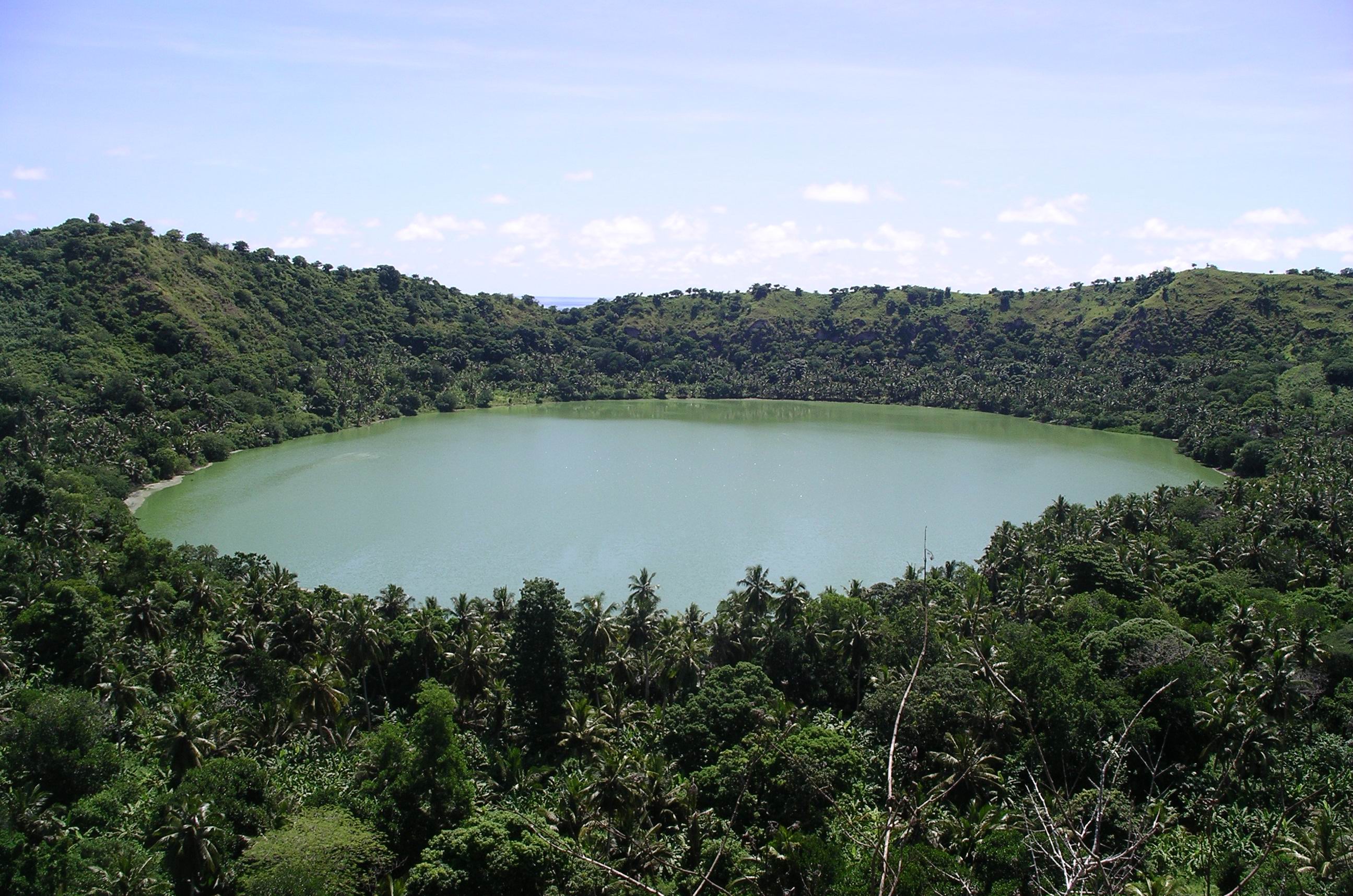
Mayotte is a French overseas department in the Mozambique Channel whose appeal goes far beyond the vivid colours of its coral lagoon. Petite-Terre has a volcanic crater lake and historical neighbourhoods, Grande-Terre has lively commercial centres, forested hills and southern beaches, and small offshore islets reveal the power of waves and tides. The islands’ Mahoran culture, languages and livelihoods are essential parts of what makes the territory worth understanding.
This guide presents ten distinct places for future planning, from Lake Dziani and Mount Choungui to the Choizil Islets and Bandrélé’s salt-making heritage. A good itinerary must compare visitor interests, access conditions and the potential costs of an excursion. The lagoon is a living ecosystem, not a vast unregulated swimming pool, and famous beaches are also important animal habitats.
On 14 December 2024, Cyclone Chido devastated Mayotte, causing severe losses and damage to buildings, roads, hiking trails, boats and tourist facilities. By 2025 many businesses had resumed at least partial service, but the Mayotte Tourism Agency’s reports described major lingering damage. UK government advice in 2026 notes that drinking-water and electricity outages may still occur and that hospital services had not fully returned. This guide therefore distinguishes the enduring significance of places from their unverified current opening conditions.
eduKate · Indian Ocean geography, people and travel learning
Choose your route through Mayotte
Ten places at a glance · Petite-Terre · Living cities and southern beaches · Forests and lagoon islets · Post-cyclone planning
Facilities and trails may differ from pre-2024 descriptions. Check local operator and official notices before driving, hiking, boating or entering the water.


Ten Mayotte places compared
These locations are geographically spread across Petite-Terre, Grande-Terre and offshore islets. A short visit should focus on one area rather than treat all ten as a single driving route. Confirm the actual reopening of trails and marine services before departure.
| Place | Why it stands out | Check before a visit |
|---|---|---|
| 1. Lake Dziani Dzaha and volcanic Petite-Terre | Unusual green crater lake and island geology | Current trails, crater edge and drinking-water restrictions |
| 2. Moya Beach and the protected eastern coastline of Petite-Terre | Coastal habitats, nesting turtles and dynamic volcanic shores | Beach access, nesting areas and sea safety |
| 3. Dzaoudzi, Boulevard des Crabes and the Musée de Mayotte | Petite-Terre urban heritage and contemporary island connections | MuMA museum schedule and barge service |
| 4. Mamoudzou’s city centre, market culture and waterfront | Experience Mayotte’s everyday urban and commercial life | Road conditions, market hours and local security |
| 5. N’Gouja Beach and the southern lagoon, Kani-Kéli | Beach forest, sea turtles and a living coral-lagoon ecosystem | Marine conditions, turtle protection and facility reopening |
| 6. Mount Choungui and southern Mayotte’s highland landscape | Conical mountain panorama and challenging hiking | Trail reconstruction, local guide and weather |
| 7. Saziley nature reserve and the southern white-sand islets | Dry coastal habitat, reef geography and remote boat experiences | Protected-zone rules, trail and boat inspections |
| 8. Choizil Islets and the northern lagoon near Mtsamboro | White-sand island scenery and marine conservation | Qualified boat operator, reef rules and tides |
| 9. Bandrélé salt pans and the southern coastal landscape | Traditional salt-making, labour and landscape knowledge | Production calendar, private working areas and restoration |
| 10. Mount Bénara and Mayotte’s central forested highlands | Upland biodiversity and views over Grande-Terre | Guide, protected-forest permissions and post-storm hazards |
1. Lake Dziani Dzaha and volcanic Petite-Terre
Why visit: Lake Dziani is one of the clearest places to see how Mayotte’s volcanic origin shapes its present landscapes. Situated on Petite-Terre, the circular basin has conspicuous green water, bare or vegetated slopes and panoramic views over the surrounding coastline. The official Mayotte tourism authority identifies it as a principal attraction and a starting point for understanding the geology of the smaller eastern island. A visit is valuable even without a demanding full trail circuit, provided there is a currently safe and legally accessible viewing location.
What the site teaches: The lake occupies a volcanic crater, but its water is unlike an ordinary mountain freshwater reservoir. Scientific work links the distinctive colour and chemistry to the lake’s unusual biological and geochemical conditions. The tourist should not guess that green water means pollution or, conversely, assume it is safe for swimming. Lake levels and shore vegetation can change, as can trail conditions after powerful storms. Mayotte’s volcanic history also includes developments beneath the sea to the east, which scientists continue to study using specialised instruments. Those processes cannot be read in full from a scenic photograph.
Practical choices and local responsibility: The December 2024 Cyclone Chido severely affected Mayotte’s infrastructure and paths, so confirm current access through the local tourism office or authorised guide instead of relying on pre-storm hiking directions. Keep clear of unstable slopes and a steep crater rim, particularly in wind or after rain. Do not descend to the lake or enter the water. A short photo viewpoint can be an alternative to a full hike for a family with limited mobility, but check the actual path surface. Respect signs protecting sensitive habitats.
Learning question: Sketch a cross-section of the crater, separate what you can see from what science has measured, and explain why the water colour cannot establish whether it is potable.
Back to the ten-place index · Next place
2. Moya Beach and the protected eastern coastline of Petite-Terre
Why visit: The Moya beaches on Petite-Terre offer a different geographical contrast with Lake Dziani. The shore faces the ocean, and stretches of sand and rocky coastal terrain provide nesting and feeding habitat for marine animals. This is a place where ecological value should be considered before beach leisure. Travellers may see a dramatic coastal outlook or wildlife traces without entering the sea, and that can be just as rewarding as a swim.
What the site teaches: The tourism authority lists Petit Moya and neighbouring eastern Petite-Terre beaches among the island’s well-known natural sites. The coastline lies in an area where volcanic formations, surf and beach sediment interact. Sea turtles use parts of Mayotte’s beaches for nesting, but identifying an animal, its life stage or the status of a particular nest requires professional knowledge. Visitors should distinguish a permitted public beach walk from entry into an actively protected nesting area. Community traditions associated with the shore also predate modern tourism facilities.
Practical choices and local responsibility: Check current beach closures and the local marine-protection rules after storm damage. Do not visit nests at night, use flash photography around wildlife, dig near tracks, handle hatchlings or chase turtles. Waves and currents on an exposed shore can be dangerous, and no beach photograph guarantees safe swimming. If an official sign or patrol indicates a restricted zone, choose a distant viewpoint. Do not move driftwood or protected debris without instruction, since material may play a role in coastal ecosystems.
Learning question: Compare the exposed coastline with the inner lagoon. Explain which differences might affect wave energy, nesting locations and the type of tourist access that is responsible.
Back to the ten-place index · Next place
3. Dzaoudzi, Boulevard des Crabes and the Musée de Mayotte
Why visit: Dzaoudzi and the nearby Boulevard des Crabes connect Petite-Terre’s natural landscapes with modern public life. The area is an important travel gateway and contains historic buildings, waterside views and the Musée de Mayotte, commonly called MuMA. Instead of treating the eastern island as only an airport transfer, take time to understand the role it plays in the archipelago’s transport, culture and historical interpretation.
What the site teaches: The Mayotte tourism office presents MuMA as a place where visitors can learn about the island’s history and Mahoran traditions, and describes the approximately fifteen-minute barge crossing to Grande-Terre. The connection illustrates how a short stretch of water can be crucial infrastructure for workers, students and goods. Mayotte’s social history combines Comorian, Malagasy, African and French influences, and contemporary residents participate in local cultural life in many languages and forms. Museum objects should be read as documented evidence, while recreated displays should be recognised as interpretation.
Practical choices and local responsibility: Confirm the current barge schedule, passenger boarding instructions and MuMA museum hours with local providers. After the 2024 cyclone, infrastructure restoration and operating changes mean older ferry advice may be unreliable. Working transport terminals are not public sightseeing platforms, and local people should be able to move without visitors obstructing them. Respect places of worship, administrative facilities and the privacy of residents. If the museum is not open, a permitted public walking route can still explain the relationship between the port and the settlement.
Learning question: Draw a diagram of the barge crossing between the two principal islands. Why might a short ferry ride be more important to daily life than a longer recreational boat excursion?
Back to the ten-place index · Next place
4. Mamoudzou’s city centre, market culture and waterfront
Why visit: Mamoudzou is the administrative and economic heart of Mayotte on Grande-Terre. Visiting public market areas, recognised waterfront streets and everyday shopping districts reveals much more about the island than a panorama taken from offshore. The town is a place where many people work, trade and connect with the passenger barge, not a heritage exhibition arranged for tourists. An unhurried, respectful city visit provides essential context before exploring protected beaches or rural villages.
What the site teaches: Mayotte Tourism describes Grande Mamoudzou as the territory’s dynamic centre. Its street life and markets connect agricultural products, imports, local cooking and community interactions. Travellers should avoid assuming every spice or souvenir has a single uniquely local origin: commerce has long linked Mayotte to other islands across the Mozambique Channel and Indian Ocean. Colonial administration, Mayotte’s contemporary status as a French overseas department and the island’s diversity all shape the urban story. Public infrastructure is also central to recovery after severe weather, and reconstruction is not a spectacle.
Practical choices and local responsibility: Consult current advice about safe areas, transport and opening times, particularly given possible public-service interruptions. UK travel guidance notes some electricity and drinking-water outages can still occur following Chido and recommends checking conditions locally. Stay on normal pedestrian routes, use reputable local transport and do not wander into temporary construction or restricted municipal areas. Markets are working spaces; ask before photographing vendors and respect what sellers choose to explain. Public facilities may not operate on the same schedule as a resort hotel.
Learning question: Choose three products at a market and ask where they were grown or obtained. Note what a seller directly confirms and what you would need further evidence to establish about transport or trade.
Back to the ten-place index · Next place
5. N’Gouja Beach and the southern lagoon, Kani-Kéli
Why visit: N’Gouja is one of Mayotte’s iconic southern beaches. It brings together sand, a coastal fringe with large trees and shallow water that can support turtle observation at suitable times. The Mayotte tourism authority specifically highlights the location as an encounter between terrestrial wildlife and the marine environment. The site is worth including because a responsible visitor can learn about the connections between beach vegetation, seagrass, reef habitats and local conservation.
What the site teaches: Mayotte’s makis, the island’s lemurs, can be associated with some vegetated coastal areas, and marine turtles use parts of the lagoon. Both should be observed without feeding or contact. The presence of a protected species is not a guarantee that it will appear at a scheduled hour. Coral and seagrass are vulnerable to trampling, anchor damage and disturbed sediment. The same lagoon that attracts travellers also supports ecological processes important to fish and the broader coastal food web. Cyclone Chido affected tourism businesses and marine infrastructure across Mayotte, so pre-2024 promotional imagery cannot tell readers what is currently available.
Practical choices and local responsibility: Check whether the beach approach, parking and any tourism facility have reopened fully after repairs. A safe shore walk does not imply safe snorkelling, and a responsible operator must assess currents, equipment and wildlife-protection practices. Never chase, touch or surround a turtle, and never feed a maki. Stay off coral, avoid stepping into seagrass beds and follow local marine-park advice. Families uncomfortable in deep water can focus on the shoreline and natural history instead of taking a risky swim.
Learning question: Compare the role of beach forest, shallow seagrass and offshore coral. What species or ecological processes depend on each, and what could visitor disturbance change?
Back to the ten-place index · Next place
6. Mount Choungui and southern Mayotte’s highland landscape
Why visit: Mount Choungui dominates southern Mayotte and provides one of the best opportunities to understand the island’s landforms from above. Mayotte Tourism describes its summit as 594 metres high, with far-reaching views over the southern land and lagoon. The mountain is valuable as a geographical subject even if visitors do not reach the summit. Its distinctively steep shape contrasts with the broad shallow sea and neighbouring hills.
What the site teaches: An elevated outlook can help reveal how settlement, cultivated slopes, roads and coastline relate to volcanic relief. But a mountain is also an ecosystem where plant communities respond to weather and altitude, and where storms can change trail surfaces. The official tourism office mentions the aromas and crops associated with Mahoran flora, including ylang-ylang and vanilla. These products reflect human cultivation as well as natural conditions; a few trees visible from a trail do not prove that every slope was once farmed in the same way.
Practical choices and local responsibility: The tourism sector’s own post-Chido reports documented severe impacts on hiking routes and service providers. Do not assume a previously published summit route remains open or safe. Check with the local tourist information centre, a current guide and weather services before deciding to climb. The route can involve serious effort and slippery terrain, and it is not suitable for every family member. Carry water, protection from sun and rain, a reliable map and a return plan. Where conditions are uncertain, enjoy the mountain from a lawful lower viewpoint.
Learning question: Compare the vertical gain of an upland route with its horizontal map distance. Explain why an apparently short ascent may require more effort than a much longer flat coastal walk.
Back to the ten-place index · Next place
7. Saziley nature reserve and the southern white-sand islets
Why visit: The Saziley area combines dry southern landscapes, coastal views and excursions to small sand islets. It is a strong choice for travellers who want to understand why Mayotte’s shores vary across a relatively compact island. From approved viewpoints visitors can observe the relationship between land, lagoon and offshore reef systems without needing to enter sensitive habitats or book an adventurous boat trip.
What the site teaches: Mayotte Tourism describes the walking route toward the Saziley reserve and views toward an îlot de Sable Blanc, a striking white-sand islet. The sand’s position depends on waves, tides and sediment movement and can change over time, so a low-tide photograph is not a fixed map. Protected habitats may contain nesting birds, marine turtles or vegetation that should not be disturbed. These habitats also face threats from severe tropical weather and human activity. A guide can explain site conservation more accurately than a visitor can infer from a clear-water photograph.
Practical choices and local responsibility: Seek current official information on trail reopening and boat operators. The 2024 cyclone significantly damaged marine and walking infrastructure, making older promises of routine excursions unreliable. Stay on permitted reserve paths and obey nesting-area restrictions. Offshore trips require safe weather, properly equipped vessels and an organised return. Exposed sand islets may have little shade and no facilities, so carry water and sun protection. Never remove coral, shells from protected zones, or animals, and avoid entering a breeding colony.
Learning question: Draw the coastline, a sand islet and the outer reef on a simple map. Explain why a sandbank visible at one tide or season might have a different outline later.
Back to the ten-place index · Next place
8. Choizil Islets and the northern lagoon near Mtsamboro
Why visit: The Choizil Islets in the north of Mayotte are known for their striking white sand and turquoise water. Their position between the Mtsamboro coast and the lagoon makes them a good place to learn about the physical geography of shallow tropical seas. The official tourist authority describes boat access and a sand spit that can connect the islets at low tide. This distinctive form can be appreciated through maps and an authorised excursion without treating every exposed surface as public land.
What the site teaches: A sand spit is a moving accumulation shaped by waves and tidal currents. It can be hard to judge distances when the water is extremely clear, and a shallow appearance can conceal channels. The area supports marine organisms, and snorkelling advertisements should not be understood as conservation clearance. Islands that contain no buildings may still have land-use rules or protected habitat. The northern lagoon also lies close to communities for whom fisheries, transport and marine space matter beyond tourism.
Practical choices and local responsibility: Use an appropriately insured local guide or boat operator, and confirm permitted landing areas, current tide stage and safe weather. Mayotte Tourism’s descriptions refer to an excursion made under favourable conditions, not an all-year guarantee. Even when a sand connection appears at low water, the return route can change; do not walk unaccompanied to another island without checking the guide’s instructions. There is often little or no natural shade on exposed sand, so prepare for heat and hydration. Keep to reef-safe practices and remove your rubbish.
Learning question: Sketch the two islets at high and low tide, showing a possible connecting sand spit. What evidence would you collect to understand how its position changes throughout the year?
Back to the ten-place index · Next place
9. Bandrélé salt pans and the southern coastal landscape
Why visit: The salt-producing landscape around Bandrélé offers a cultural and economic complement to Mayotte’s famous beaches. Salt extraction is an example of how people use an environmental process—seawater evaporation—to produce something essential to food and trade. Its interest lies in the knowledge of working with sun, water, soil and containers, rather than in the assumption that every visible salt pan is a decorative attraction.
What the site teaches: Traditional salt production links the chemistry of evaporation with local labour and land management. Historical accounts in Mayotte discuss women involved in artisanal salt-making, and presentations can offer insight into techniques passed between generations. A visitor needs to distinguish a functioning work area from a heritage demonstration or an abandoned pan, and to recognise that economic conditions change. It would be misleading to promise that a production workshop operates at a fixed hour without first contacting the people who do the work. Mayotte’s trade relationships across the Mozambique Channel provide useful context for how such techniques developed.
Practical choices and local responsibility: Arrange a visit through a local tourism or cultural operator rather than entering working pans uninvited. The area may be affected by weather, reconstruction activity and changes to production. Do not touch salt piles, production tools or stored water without permission. Respect the workers’ instructions and ask before photographing them. A nearby beach has separate water and access risks, so do not infer safe swimming from an enjoyable craft demonstration. If no demonstration is available, learn from a reliable interpretation or a permitted public viewpoint.
Learning question: Make a flow diagram from seawater to concentrated brine and salt crystals. Identify the role of sun, temperature, wind, tools and human care without pretending that simply leaving a container outdoors gives an identical commercial product.
Back to the ten-place index · Next place
10. Mount Bénara and Mayotte’s central forested highlands
Why visit: Mount Bénara provides a different highland landscape from the southern cone of Choungui. The central heights support forest and offer an opportunity to think about how rainfall, topography and land use shape the island’s ecosystems. A nature-focused traveller may find the area rewarding, but a mountain route should be selected based on verified safety and ecological rules rather than the desire to complete every high point on a travel list.
What the site teaches: Mayotte Tourism’s regional development publications identify major forest reserves and important volcanic landscapes. Some of the remaining vegetation is valuable for biodiversity, yet forests also face pressure from land clearing, invasive species and increasingly extreme weather. Cyclone Chido brought widespread wind damage, which can leave unstable trees long after a storm. A plant growing on a ridge tells part of the environmental story, but identifying its species or conservation status requires informed interpretation. Responsible travel recognises forests as functioning ecosystems, not merely a backdrop to an adventurous selfie.
Practical choices and local responsibility: Check the present legal trail status, forest-service guidance and route difficulty with qualified local providers. Do not enter a damaged forest or attempt improvised shortcuts after the cyclone. Hikes may be slippery, hot and physically demanding, with very limited phone coverage or rescue access. A local guide should help assess weather, return time and which paths can be used without harming protected plants. For people with limited mobility, a suitable public roadside view and the educational materials of the island’s tourism agency can provide a safer alternative.
Learning question: Compare a forested central slope with an exposed coastal area. Which differences could be explained by rainfall and wind, and what longer-term measurements would be needed to test the explanation?
Back to the ten-place index · Plan a trip
Planning Mayotte with post-cyclone realities in mind
A short first visit can begin on Petite-Terre with Lake Dziani and the Musée de Mayotte, if their current sites are open. Mamoudzou then offers a different experience of local culture and commerce on Grande-Terre. A separate southern outing may include N’Gouja and a safe viewpoint of Mount Choungui, but should not require a difficult mountain ascent or assume that all resort facilities are operating. More remote lagoon-islet trips demand extra preparation, weather assessment and boat capacity that may still be affected by reconstruction.
Travel plans must not treat the entire 2024 storm-damaged tourism sector as one uniform condition. The Mayotte tourism agency has documented phased reopening, including many businesses operating with reduced capacity. That is not a promise about the lodging, guide or jetty you intend to use. Book locally, ask for written confirmation when possible and prioritise businesses that can meet safety and environmental requirements. Travel insurance and an emergency plan matter particularly for water-based activities.
Before choosing an excursion
- Confirm the actual condition of your hotel, drinking-water and electricity supply, airport transfer and health services. UK FCDO guidance notes that post-Chido outages remain possible.
- Obtain current trail conditions from local tourism or land managers. Damaged footpaths, unstable trees and landslides can persist long after a storm.
- Use qualified boat and dive operators who can demonstrate appropriate safety equipment, maintenance, return plans and marine-protection practices.
- Observe dolphins, turtles, reef fish, lemurs and nesting birds without feeding, touching or chasing them. Sightings must never be guaranteed.
- Check current beach and water conditions. A shallow lagoon photograph does not establish safe swimming, especially after heavy rain or wind.
- Mayotte’s cyclone season generally runs December to April. Monitor Météo-France and local authority forecasts, including outside the main season.
- Respect local villages, religious sites, working markets, craft producers and private property. Ask permission before photographing people at close range.
- Use the appropriate entry and travel document advice for your nationality. Mayotte’s administrative status as a French overseas department does not remove the need to confirm specific rules.
Three routes for different types of visitor
A family wanting gentle learning could choose a properly open MuMA visit, a lawful crater-lake viewpoint and a market walk. Geology enthusiasts may compare Dziani with the visible slopes of Choungui, setting aside any unverified summit plan. Marine-science travellers could consider the Choizil or Saziley area with a currently licensed operator, while accepting cancellations and possible habitat restrictions. A visitor interested in cultural history might explore Bandrélé’s salt-producing traditions and conversations with local guides, prioritising fair participation rather than a staged photo opportunity.
Frequently asked questions
Is Mayotte part of France?
Yes. Mayotte is an overseas department of France in the Indian Ocean. Visitors should check specific entry requirements and local rules for their nationality rather than assume every aspect of mainland France applies identically.
Can tourists still visit Mayotte after Cyclone Chido?
The tourism sector has been reopening in stages, but some facilities and services have experienced long-term disruption. Confirm exact hotels, trails, operators, water supply and transport rather than relying on pre-2024 guides.
Is Lake Dziani safe for swimming?
No visitor should treat it as a recreational freshwater pool. The lake has unusual chemistry and steep volcanic surroundings; the appropriate experience is a safe permitted viewpoint and scientific interpretation.
Can I swim beside sea turtles at N’Gouja?
Wild turtles may be present but should never be pursued, surrounded or touched. Any snorkelling depends on water conditions, current conservation rules and appropriate supervision.
Does Mont Choungui require a serious hike?
The full ascent is physically demanding, and post-cyclone trail conditions must be checked. A permitted lower vantage point may provide a better choice for many visitors.
How do I visit the Choizil Islets?
Arrange with an appropriately authorised local boat operator, confirming the sea state, tide, landing rules and safe return. Do not attempt to walk across exposed sandbars without guidance.
Are tourism services on Mayotte fully restored?
The destination’s recovery reports and current government advice describe reopening alongside some remaining shortages and disruptions. Ask each provider for a current operational update.
Which sites are best for studying local culture?
The Musée de Mayotte, Mamoudzou’s public market environment and the Bandrélé salt-making landscape offer complementary forms of cultural learning, depending on access and available interpreters.
Field-learning notes: compare what you see with what sources establish
Mayotte is an excellent setting for comparing land and sea without assuming every photograph represents current conditions. At Lake Dziani, note the shape of the crater and distinguish it from a chemical account of the water. At a southern shore, compare a turtle’s natural behaviour with a guide’s interpretation. In Mamoudzou or Bandrélé, make space for the explanations of people who work and live there rather than constructing a story from scenery alone.
A simple map question can connect Mayotte travel with Mathematics: why is the passenger-barge crossing between Petite-Terre and Grande-Terre essential even though the islands appear close? How do waiting time, safety, route and service reliability alter journey length? For related examples of step-by-step explanation, eduKate’s Secondary 1 Mathematics Tutor Clementi | Small Groups Tutorials illustrates the importance of justifying a conclusion instead of guessing.
Continue learning about Mayotte
Top 10 Things to Do When Visiting and Touring Mayotte · Top 10 Things to Learn When Visiting and Touring Mayotte · World Country Directory
Sources and current-information checks
Sources reviewed 18 October 2026 (Singapore time), including official tourism recovery reporting and travel safety information. Older guides and the 2010 archive photograph do not establish current facility status. Follow the latest local announcements and operator notices before committing to an itinerary.
- Mayotte Tourism — official site and destination collections
- Mayotte Tourism — Petite-Terre, Dziani, Moya and MuMA
- Mayotte Tourism — the south, N’Gouja, Choungui and Saziley
- Mayotte Tourism — Choizil islets
- Mayotte Tourism — visitor services restored after Cyclone Chido (2025 assessment)
- Mayotte Tourism — post-Chido tourism-sector damage
- Mayotte Tourism — 2026 visitor and small-business recovery activity
- UK FCDO — Mayotte travel advice
- UK FCDO — Mayotte safety, Chido disruption and marine operators
- WMO — December 2024 Cyclone Chido impact
- Wikimedia Commons — archive photograph by Peioma CC BY-SA 3.0
- Creative Commons — BY-SA 3.0 licence