
What are the best places to visit on Neuwerk? Begin with its medieval Great Tower, then explore the surrounding Turmwurt heritage and the Nationalpark-Haus’s interactive Wadden Sea exhibition. Walk part of the ring dike to understand the island’s geography. Traditional approaches from Cuxhaven include a horse-drawn Wattwagen and seasonal MS Flipper passenger ship. For outdoor exploration, consider the Ostbake, North Foreland bird views, modern radar tower and protected panoramas towards Scharhörn and Nigehörn. These ten places and experiences tell the story of an extraordinary Hamburg island in the North Sea.
Neuwerk is a small, inhabited island in the Hamburg Wadden Sea National Park, lying offshore from Cuxhaven while administratively belonging to the City of Hamburg. Its famous brick tower was completed around 1310 as a fortified watchtower guarding the Elbe approach. Neuwerk is a place where the tide decides transport: a passenger vessel, guided walk or Wattwagen horse carriage operates under different water and weather conditions. A carefully planned day is possible in the right season, but an overnight stay gives more flexibility for nature and heritage.
Critical November 2026 updates: Hamburg announced a major restoration of the Great Tower in May 2026, with work expected to continue to approximately 2028. Do not plan to climb or stay overnight in the tower based on older descriptions. MS Flipper runs primarily during a seasonal spring-to-autumn period, with no guaranteed ordinary passenger service in November. The Nationalpark-Haus’s official 2026 events calendar covers April–October, so winter opening must be checked. Mudflat crossings and wildlife areas are not safely accessible without local guidance and the relevant permissions.


The ten Neuwerk places and experiences at a glance
- 1. The Great Neuwerk Tower: Hamburg’s Medieval Landmark — Fourteenth-century fortification and lighthouse history under restoration.
- 2. Turmwurt, Historic School Buildings and Archaeological Heritage — Archaeology, preservation and the island’s historic built environment.
- 3. Nationalpark-Haus Neuwerk and Its Living Tide Basin — Interactive Wadden Sea ecology, marine life and free nature education.
- 4. Neuwerk Ring Dike and the One-Hour Island Circuit — Easy island orientation, meadows and storm-protection engineering.
- 5. The Sahlenburg Wattwagen Horse-Carriage Crossing — Traditional transport, low tide and a memorable guided arrival.
- 6. MS Flipper Sea Voyage from Cuxhaven Alte Liebe — Seasonal passenger shipping, estuary views and ferry logistics.
- 7. Ostbake: The Eastern Wooden Navigation Beacon — Historic sea mark, navigation and sensitive coastal access.
- 8. North Foreland and Wadden Sea Birdwatching — Migratory bird habitats, saltmarsh and quiet observation.
- 9. Neuwerk Radar Tower and the Ships of the Elbe — Modern maritime technology and a distinctive shipping outlook.
- 10. Views Toward Scharhörn, Nigehörn and Protected Offshore Wildlife — Bird reserves, conservation boundaries and changing island geography.
This list combines destinations on Neuwerk with two important ways to reach it. They are not all separate ticket attractions. The tower and Turmwurt are a central historic group, the National Park centre adds nature interpretation, and the ring dike is a practical walking route. Wattwagen and MS Flipper are transport experiences with different seasonal availability. The bird areas and navigation structures are best appreciated from permitted public viewpoints.
Fast choices for different travellers
- First visit: Great Tower exterior, Nationalpark-Haus if open and a short dike walk.
- Families: A booked Wattwagen crossing in suitable conditions and interactive tide exhibits.
- History: The medieval tower, Turmwurt and archaeology interpretation.
- Maritime technology: Radar tower, historic lighthouse and estuary ship views.
- Nature: Nordvorland and protected Scharhörn panoramas with binoculars.
- Longer outdoor excursion: Guided mudflat or seal-viewing programme when available.
- November: Do not presume MS Flipper runs or tower access is available.
- Safety rule: Never attempt a self-directed tidal-flat crossing or entry to Nigehörn.
1. The Great Neuwerk Tower: Hamburg’s Medieval Landmark
Where: The Turmwurt raised site in the centre of Neuwerk. Best for: Fourteenth-century fortification and lighthouse history under restoration.
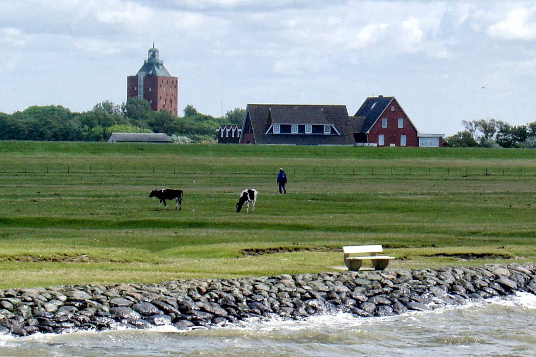
The Great Tower of Neuwerk is the island’s unmistakable landmark, a powerful square brick structure that illustrates Hamburg’s long relationship with the Elbe estuary. Completed around 1310 as a fortified watchtower, it is one of Hamburg’s oldest surviving non-religious buildings. Its role changed over time, and a beacon was established in the nineteenth century before modern navigation systems reduced its original need. The island belongs administratively to Hamburg even though it lies far out in the North Sea near Cuxhaven. This geographical oddity becomes easier to understand when the tower is seen as a medieval way of securing access to an important commercial waterway.
An essential November 2026 fact is that the tower is under major renovation. The Free and Hanseatic City of Hamburg announced the active restoration project on 22 May 2026, with exterior and interior works planned through roughly 2028 and a future reopening connected with hotel and restaurant use. Do not rely on older tourist pages promising a 138-step climb or overnight accommodation inside. Those descriptions belong to an earlier operating arrangement and conflict with the 2026 construction notice. View the historic tower from lawful public positions away from scaffolding, construction vehicles and any exclusion area, and follow the latest official visitor information.
Why does a city nearly one hundred kilometres away maintain such a tower? The answer involves trade, maritime navigation, sovereignty and a centuries-long need to protect access to the Elbe. The structure’s continuing renovation is also a lesson in conservation: old brickwork, damaged surfaces and complex construction conditions require specialist craft and careful scheduling. A visitor can appreciate the historic value without climbing or entering it. The tower’s silhouette against the sky remains a powerful illustration of how one small island helped support a much larger commercial network.
Route suggestion: Use the tower exterior as the central historic landmark, but make any interior climb or hospitality booking unavailable until an official reopening is confirmed.
Back to the ten places · Next stop
2. Turmwurt, Historic School Buildings and Archaeological Heritage
Where: The raised settlement around the Great Tower. Best for: Archaeology, preservation and the island’s historic built environment.
The Turmwurt is the raised mound carrying the tower and several neighbouring historic buildings. The setting explains why the Great Tower cannot be understood alone: a fortified structure needed storage, access, people and practical surroundings. Neuwerk also contains historic school and agricultural buildings that form part of this protected ensemble. In 2026 Hamburg planned archaeological investigations of the mound as part of the tower restoration, examining foundations and the earlier development of the site. This is an attractive place to learn how built heritage and physical geography meet, since a raised settlement can preserve traces of centuries of human activity.
The ongoing work changes what can be visited. The city’s 2026 announcement discussed building rehabilitation, construction access and archaeological excavation, not an unrestricted outdoor museum where every structure is open. Stay behind any barriers and avoid approaching equipment or work teams. Do not try to enter school or residential buildings, and do not touch exposed historical material. A tour should rely on current heritage interpretation or an arranged professional guide rather than allowing visitors to roam through excavation areas. An exterior viewpoint from a lawful path can still provide the wider picture of the tower’s role in island life.
Archaeology is a good example of the difference between observation and inference. A foundation or shard may be physical evidence, but its purpose needs careful interpretation. Archaeologists record context, depth and relation to other objects before making historical claims. The 2026 restoration gives a present-day reason to consider this work: repairing a landmark can uncover new information about its past. Ask why maintaining the building may need to be coordinated with documenting the ground around it. That relationship between conservation and research is more interesting than a quick photograph of scaffolding.
Route suggestion: Pair with the Nationalpark-Haus when open, and keep all construction and excavation areas outside the walking itinerary.
Back to the ten places · Next stop
3. Nationalpark-Haus Neuwerk and Its Living Tide Basin
Where: Insel Neuwerk 6, about 200 metres from the tower. Best for: Interactive Wadden Sea ecology, marine life and free nature education.
The Nationalpark-Haus Neuwerk is one of the strongest destinations for first-time visitors because it explains the island’s surroundings rather than treating the Wadden Sea as a broad empty mudflat. Located near the tower, it contains interactive exhibits on tidal processes, native plants, bird migration, the history of Neuwerk and its neighbouring small islands Scharhörn and Nigehörn. The large tide basin makes the movement of water tangible and helps explain the connection between organisms that survive in mud and the birds that feed on them. A visit gives adults and children an understanding of the natural system that has shaped island transport and settlement.
The National Park authority says the exhibition has free entry during operating periods and provides separate seasonal dates and a programme of guided activities. Its published 2026 events focus on April to October, so November visitors should not infer a permanently staffed daily museum from the general description. Check the current schedule with the centre before making it an essential part of travel. Guided mudflat walks, birdwatching, seal-viewing and historical tours require their own arrangements and can be cancelled because of weather. A visitor might enjoy the indoor exhibition when available, but that does not confer permission to walk independently into protected flats.
An excellent learning question is why a mudflat can support so much life despite looking featureless. Tiny organisms, shellfish and other animals create food opportunities for birds during migration. The tide basin helps illustrate that the same environment may be exposed, covered or partly flooded through the day. The centre also emphasises the protected status of nearby Scharhörn and Nigehörn. Ask how researchers collect evidence about migrating birds without disturbing them. This makes the visit a gateway to more responsible outdoor observations.
Route suggestion: Check seasonal opening first, then choose any additional guided activity from the centre’s current programme.
Back to the ten places · Next stop
4. Neuwerk Ring Dike and the One-Hour Island Circuit
Where: Public dike route surrounding the inhabited core. Best for: Easy island orientation, meadows and storm-protection engineering.
A circuit along Neuwerk’s ring dike is one of the simplest ways to appreciate the island’s scale. Hamburg’s tourism information describes a route of roughly one hour around the island, passing views of green meadows, farm buildings, saltmarshes and the surrounding sea. This is an excellent alternative to a long excursion across tidal flats because it keeps the visitor close to a managed land boundary while offering different perspectives on the landscape. The dike is not merely a scenic walking surface. It is a maintained coastal protection structure that helps make everyday life possible on low-lying land exposed to storms.
Follow public paths and observe any temporary closures or construction notices. The actual time required depends on your pace, weather and whether you stop for photographs. Strong wind, rain or slippery grass can make the walk more difficult than its approximate one-hour description suggests. Stay away from livestock and respect private farm gates. A dike may be part of public visitor access in one section while another is closed for maintenance or nature protection. Check which route is currently appropriate, especially when construction activity around the central tower increases local traffic or affects pedestrian paths.
Ask why an island community needs a ring dike and how it differs from the raised residential mounds on North Frisian Halligen. A dike protects a broader area from ordinary or some higher water conditions, but it still requires maintenance and does not make the environment completely risk-free. The circuit gives a panoramic view of the relationship between engineering, agriculture and saltmarsh habitat. It is a valuable place for children to compare what is inside the protected settlement area with what lies outside toward the Wadden Sea.
Route suggestion: Choose this for a flexible short nature outing with a clear return to the village, not as an invitation to leave the dike and cross tidal channels.
Back to the ten places · Next stop
5. The Sahlenburg Wattwagen Horse-Carriage Crossing
Where: Cuxhaven-Sahlenburg to Neuwerk across marked tidal-flat routes. Best for: Traditional transport, low tide and a memorable guided arrival.
A Wattwagen journey to Neuwerk is one of Germany’s most distinctive ways of reaching an island. Horse-drawn wagons travel across the exposed Wadden Sea from the Sahlenburg beach area during a suitable tidal window, bringing passengers through a landscape that will later be covered by water again. The experience combines traditional local skill, wildlife observation and a clear practical understanding of tides. Unlike a permanent road or causeway, the crossing relies on current conditions and operator judgement. The route should be understood as a supervised transport service, not as proof that every visitor can travel wherever the flats look dry.
Reputable local providers publish tide-dependent schedules and meeting points in Sahlenburg, with the return also requiring its own booking. The service may be seasonal, and weather or water levels can cause cancellations. Ask about the duration, animal welfare, seating, children and mobility needs before booking. A November visitor should not simply copy a July timetable or assume a horse-drawn wagon is running on demand. The most dangerous mistake is to follow a wagon route independently in an ordinary rental vehicle or on foot without trained guidance. The Wadden Sea contains soft mud and tidal channels that can flood unexpectedly.
A useful question is why a horse carriage can cross a seabed only at particular times. Water depth, sediment condition, tides, temperature and weather all influence the safe window. The driver needs route knowledge and practical judgement that a phone navigation app cannot substitute. The journey also makes it easy to see the difference between observing nature and controlling it: visitors can plan around predictable tidal patterns, but cannot demand that the sea remain low until everyone is ready to return.
Route suggestion: Book both directions with an authorised operator and coordinate accommodation or onward ferry arrangements before choosing sightseeing.
Back to the ten places · Next stop
6. MS Flipper Sea Voyage from Cuxhaven Alte Liebe
Where: Cuxhaven port to Neuwerk via the Elbe estuary. Best for: Seasonal passenger shipping, estuary views and ferry logistics.
The seasonal passenger vessel MS Flipper provides another striking route to Neuwerk, travelling from Cuxhaven’s Alte Liebe landing area through the busy waters near the mouth of the Elbe. The crossing is a contrast with the horse-drawn Wattwagen: instead of rolling over exposed mud, passengers travel by water when the tide and channel conditions permit. From the ship, the scale of commercial maritime traffic and the low island landscape may be apparent. The boat journey offers a clear explanation of why Neuwerk has been strategically important to Hamburg for centuries, far beyond the appeal of a small tourist destination.
The 2026 operator timetable describes a seasonal service from spring until the latter part of October; a November trip should not assume normal MS Flipper sailings remain available. Check directly with Reederei Cassen Eils for any special voyage rather than copying the earlier year’s schedule or a third-party price. The crossing is approximately two hours in regular conditions, but actual trip duration, boarding arrangements and weather interruptions may vary. The mainland departure is at Cuxhaven rather than Schlüttsiel, Harlesiel or a neighbouring island’s terminal. Book the return separately if appropriate and allow time for the route from Neuwerk’s pier to the main island settlement.
A ship can only follow suitable channels with adequate depth, and its operation requires trained crew, maintenance, navigation and reliable boarding arrangements. Compare the MS Flipper with the Wattwagen crossing: both reach the same island but use different environments and departure windows. A tide that makes one method convenient may create a different constraint for the other. This shows why multiple types of local transport can exist without being interchangeable. It also encourages careful trip planning instead of expecting every operator to follow the same timetable.
Route suggestion: A seasonal approach, not a guaranteed November sightseeing service; always verify an actual sailing before planning a day trip.
Back to the ten places · Next stop
7. Ostbake: The Eastern Wooden Navigation Beacon
Where: Eastern foreland of Neuwerk, reachable only on permitted paths. Best for: Historic sea mark, navigation and sensitive coastal access.
The Ostbake is a wooden navigation beacon standing in the eastern foreland of Neuwerk. It belongs to a long tradition of practical sea marks in the Elbe estuary, where ships and local travellers once depended on visible structures for orientation before modern electronics. The beacon is visually quite different from the enormous medieval brick tower in the island’s centre. It is a quieter landmark that reveals how navigation infrastructure can be distributed across a coastline rather than concentrated in one high building. Its open setting also illustrates the relationship between maritime history and the saltmarsh habitat that surrounds it.
The eastern foreland is part of a protected national park environment. Use only current signed routes and follow the authority’s instructions, as some areas are closed to protect birds and vegetation. Do not walk directly across saltmarsh or mud to reach the beacon for a closer photograph. Tidal water and soft ground can create danger even when a landmark appears near on a map. The wood itself may be fragile or operationally restricted; admire it from a legal viewing position rather than climbing or touching it. A short guided nature-and-history walk may be the safest way to gain useful context.
The Ostbake asks an accessible question: why would a tall brick tower and a small wooden beacon both be useful? Different positions and visual characteristics can help with orientation along complex channels. The lesson extends to modern navigation: GPS and radar provide important information but still depend on systems, trained users and safe route planning. Physical sea marks are also reminders of the history of trade and shipping. The protected marsh setting shows that infrastructure and habitat need to coexist carefully.
Route suggestion: Pair with an authorised eastern island nature circuit; never use the beacon as a reason to enter off-limit marshland.
Back to the ten places · Next stop
8. North Foreland and Wadden Sea Birdwatching
Where: Nordvorland, coastal viewpoints beyond the ring dike. Best for: Migratory bird habitats, saltmarsh and quiet observation.
The Nordvorland north of Neuwerk is a prime place to appreciate the Wadden Sea as a living protected environment. Saltmarshes and tidal flats create feeding and resting habitats for migratory birds that travel across Europe and beyond. The area’s appearance can change dramatically with water level and season, from exposed muddy ground to a broad shallow sea. A visitor who arrives after a horse-carriage ride may initially see only an open landscape. Careful interpretation reveals a web of food, plants and movement in which small organisms support much larger birds. The atmosphere is often best appreciated quietly, without trying to reach every exposed sandbank.
Choose permitted viewpoints, national park routes or a guided birdwatching programme. The local Nationalpark-Haus has offered seasonal sessions on returning migratory birds, and guides can help guests choose appropriate observation positions. In November the event calendar may be reduced; check actual availability. Use binoculars and keep dogs under control. Do not step into a feeding flock for a photograph or cross a protected saltmarsh because it appears to be a shortcut to the water. Some birds rest or feed in ways that are not obvious from a distance, and repeated disturbance can use energy they need during migration.
Birdwatching is a good exercise in evidence and humility. Identify what you can genuinely observe—size, shape, movement, group behaviour—then consult a guide before naming an unfamiliar species. The Wadden Sea’s global importance comes from ecological processes and the scale of seasonal wildlife use, not the guarantee that a rare bird will pose for a visitor on demand. A quiet legal viewpoint can be a powerful experience, particularly when linked to an earlier exhibition about tidal food webs.
Route suggestion: Make this the nature focus of a short outing when the weather is suitable; do not improvise a route through protected core zones.
Back to the ten places · Next stop
9. Neuwerk Radar Tower and the Ships of the Elbe
Where: Western Neuwerk, near Nige Hus. Best for: Modern maritime technology and a distinctive shipping outlook.
Neuwerk’s radar tower stands in the western part of the island and provides a modern technological contrast with the Great Tower built in the fourteenth century. The radar installation helps with maritime monitoring and is visible from much of the island. Its setting near the Elbe estuary is significant because large vessels travel towards the Port of Hamburg through waterways that require careful navigation and traffic management. For visitors interested in engineering, the visual comparison between an old brick fortress and a modern technical tower can be one of the most informative parts of a Neuwerk holiday.
The radar tower remains an operating facility rather than a public observation attraction. Local visitor information states that the exterior can be seen from public routes, but the interior is not generally accessible. Do not approach fenced installations or attempt to enter working technical buildings. Choose a permitted western view, perhaps near the public coast route, and watch distant shipping without obstructing local activity. Strong wind and weather can make an exposed viewpoint uncomfortable, so bring layers and allow the group to turn back. A child interested in ships may enjoy this stop without needing any tower climb.
Ask what information radar supplies that an old lighthouse could not. A light gives a visual reference to a vessel, while radar can help detect objects and traffic under other conditions. Modern navigation also involves communication, trained crews and maintained systems. No single tower can make every passage safe on its own. This contrast helps visitors understand the idea of layers of safety, and why technological infrastructure continues to matter even after a historic lighthouse is retired or restored for cultural purposes.
Route suggestion: Combine with the ring dike circuit and a safe western viewpoint; respect the tower as working infrastructure.
Back to the ten places · Next stop
10. Views Toward Scharhörn, Nigehörn and Protected Offshore Wildlife
Where: Authorised Neuwerk viewpoints facing the western sandbanks. Best for: Bird reserves, conservation boundaries and changing island geography.
From suitable Neuwerk viewpoints, the wider Hamburg Wadden Sea may bring Scharhörn and Nigehörn into the picture, two nearby low islands within the national park. Scharhörn has a history of bird wardens and scientific protection, while Nigehörn was created as an artificial island and is subject to strict conservation rules. These are not ordinary resort islands to visit independently whenever the mud appears exposed. The attraction for most Neuwerk visitors lies in understanding the protected offshore landscape and the way sediment, water and birds interact beyond the inhabited island.
Official National Park material describes guided Scharhörn outings on selected dates, but such trips require special planning, the correct tide and compliance with visitor restrictions. The neighbouring Nigehörn is not generally open to casual visitors. Do not attempt to reach either island using an old GPX route or a social-media video of people walking across dry flats. Tidal channels, fog and soft sediment create serious risks, and conservation regulations protect birds from disturbance. A distant view or a Nationalpark-Haus exhibition is a completely valid alternative. If a legitimate Scharhörn visit is essential, arrange it with authorised local guides and follow all permissions.
These small islands are useful for learning why a national park may protect places that people cannot enter. Nesting birds need undisturbed ground, while new sediment can slowly create habitat and existing shorelines can change. A visitor can observe that a coastline is dynamic without crossing into the most sensitive part of it. The official visitor centre explains Scharhörn and Nigehörn, making it a natural companion to an outdoor viewpoint. Respecting the boundary is not missing the attraction; it is part of understanding its purpose.
Route suggestion: Choose an authorised island viewpoint and learn from National Park interpretation. Any visit to Scharhörn is a distinct guided trip, not a casual stop on the Neuwerk loop.
A practical day trip to Neuwerk
A safe day trip begins with choosing how to reach the island. MS Flipper from Cuxhaven’s Alte Liebe operates during its advertised season, while Wattwagen carriages from Sahlenburg use the exposed flats during suitable low-water windows. A qualified guided walk is another option for fit travellers, but it must follow an authorised route and tidal timing. Choose the outward and return transport together; an outgoing horse carriage does not mean you can spontaneously catch a passenger ship at an arbitrary hour. Off-season visitors should verify whether any provider is actually running before buying onward rail or accommodation tickets.
Once on the island, focus on the Great Tower exterior and nearby Turmwurt, then choose the Nationalpark-Haus if its current opening permits and a manageable section of the ring dike. A simple meal or rest can help a group enjoy the scenery without rushing. If the tower is surrounded by construction work, follow barriers and use a more distant viewpoint. If the visitor centre is closed, a lawful dike walk may be a satisfying replacement, but only in safe weather and with enough time to return to the booked transport.
A two-day nature and history visit
An overnight stay gives room for the historic central settlement, the Nationalpark-Haus and a slower loop around the island. A second day could be devoted to a booked nature programme, birdwatching from a permitted viewpoint or a guided outing towards Scharhörn when available and authorised. Such trips are not guaranteed during November, and the return tide must be planned carefully. Nigehörn is not an ordinary visitor destination. A relaxed overnight visit may be more meaningful for people interested in the Wadden Sea than a day squeezed between two transport windows.
Accommodation on Neuwerk is limited and seasonal, and the Great Tower’s former hotel and restaurant use is suspended during the 2026–28 restoration. Book an actual operating property, check cancellation and weather arrangements, and bring the supplies the host recommends. A destination with very little commercial activity may still have extraordinary natural history. The aim is to enjoy that environment responsibly without requiring every café, tour and historic building to be open at all times.
How to reach Neuwerk: ship, horse carriage or guided mudflat walk
Neuwerk lies off Cuxhaven and belongs to Hamburg. From Cuxhaven’s Alte Liebe terminal, the seasonal MS Flipper passenger ship is one approach; from Sahlenburg, a traditional Wattwagen travels across the exposed seabed at low water. Some guided walking trips start from Sahlenburg or Duhnen. These methods have different durations, physical requirements and availability. The ship crossing can take around two hours under ordinary conditions; the horse-wagon and walking times depend on conditions and operator. Do not quote a permanent timetable: tide, wind, channel depth and weather warnings govern the possible journeys.
Never attempt the mudflat route independently because a map shows a line to the island or a photograph reveals exposed ground. Soft sediment, navigation channels, fog and rising water create serious hazards. Use an experienced guide, confirm the meeting place, choose appropriate footwear and carry sufficient water. The strongest day trip combines the operator’s outward and return arrangements. When the ship’s season has ended, a traveller must not assume there is a convenient alternative for returning to Cuxhaven later in the day. Good local judgement matters more than completing a planned sightseeing list.
The Great Tower’s 2026–28 restoration: what has changed
The City of Hamburg’s press statement dated 22 May 2026 is the most important source for contemporary tower access. It confirms a major heritage restoration estimated at around €22 million, with scaffolding, repair works and archaeological investigations. The project aims to restore the building and allow hospitality and weddings to resume after completion, anticipated around 2028. That means guidebooks or school-hostel pages still advertising a 138-step observation climb or overnight stays may describe past arrangements. Visitors should follow the current city authority rather than treating those older pages as live admission instructions.
The restoration itself can be an interesting subject. Historic brick walls and old structural foundations need specialist care, and the logistics of transporting equipment to a tide-dependent island make even ordinary building work unusually complex. Archaeological investigations at the Turmwurt may reveal evidence about earlier phases of construction. Such work should be respected from outside safe barriers. An attractive old monument is not diminished by temporary closure; long-term conservation is how it can remain meaningful to future visitors.
National park, UNESCO World Heritage and bird protection
Neuwerk lies within the Hamburg Wadden Sea National Park and the transnational Wadden Sea UNESCO natural World Heritage property. The environmental recognition is based on tidal processes and biodiversity, not on a separate UNESCO inscription of the brick tower, radar structure or each guesthouse. Saltmarshes and mudflats support organisms that provide food for migrating birds, and neighbouring Scharhörn and Nigehörn have sensitive protected areas. Public trails allow visitors to appreciate the landscape, while other places are closed to prevent disturbance.
Use binoculars and stay on authorised routes. Never chase a bird for a closer photograph or approach seal resting grounds without a qualified guide. The Nationalpark-Haus offers essential interpretation and may arrange tours in its operating season, but the guide decides the route and may cancel because of weather or tide. Nigehörn remains a restricted wildlife island rather than an open-day-trip destination. A distant view and good ecological explanation are better than an illegal or dangerous crossing.
Family travel, mobility and changing weather
Neuwerk’s dike circuit can be an accessible introduction for some travellers, but not every segment is guaranteed level or suitable for wheelchairs and strollers. Tidal walking and horse-drawn carriage boarding have very different physical demands, so ask the operator about steps, seats and ability requirements. The Nationalpark-Haus can be a good family learning space when open, while a tower under renovation should not appear on a list of possible climbing activities. A group with small children may be best served by the sea crossing, tower exterior and a short safe dike walk, with a warm rest before the return.
November brings shorter daylight and potentially strong North Sea winds. Ship services may have ended for the season, and visitor centres often publish reduced programmes. Do not improvise a crossing because the sky looks clear at a particular moment; forecasts, tides and operator decisions govern safety. An overnight visit should include a plan for essential medication, food, communication and the possibility of weather-related delays. Responsible travel means accepting that a very small coastal community cannot provide the same transport flexibility as a mainland city.
What children and adults can learn from Neuwerk
Neuwerk connects history, infrastructure and nature in an unusually compact setting. The tower reveals medieval trade and coastal defence; the radar installation shows modern maritime technology; the ferry and Wattwagen illustrate two very different tidal travel methods; and the Wadden Sea centre explains biological processes. The ring dike and raised settlement show the importance of flood protection, while the restoration demonstrates how a community maintains heritage under logistical constraints. These connections help visitors see why the island matters beyond a dramatic photograph.
Use the simple habit of observing, suggesting and verifying. At the old tower, observe brickwork and ask why the structure was built; confirm with Hamburg’s historical records. At the dike, ask what it protects and what happens during unusually high water. At a bird viewpoint, describe movement and check species with a guide rather than guessing. At a ferry or horse-wagon departure, ask how the tide controls the safe time. One careful question at each stop is more valuable than memorising a long list of facts.
English–Chinese island travel vocabulary
- island — 岛屿 — dǎoyǔ
- medieval tower — 中世纪塔楼 — zhōngshìjì tǎlóu
- restoration — 修复 — xiūfù
- lighthouse — 灯塔 — dēngtǎ
- radar — 雷达 — léidá
- horse carriage — 马车 — mǎchē
- ferry — 渡轮 — dùlún
- tidal flat — 潮滩 — cháotān
- saltmarsh — 盐沼 — yánzhǎo
- dike — 堤坝 — dībà
- migratory birds — 候鸟 — hòuniǎo
- nature reserve — 自然保护区 — zìrán bǎohùqū
- coastal navigation — 海岸导航 — hǎi’àn dǎoháng
Frequently asked questions about touring Neuwerk
Where is Neuwerk?
Neuwerk is a small inhabited island in the German North Sea off Cuxhaven. It belongs administratively to the City of Hamburg and lies in the Hamburg Wadden Sea National Park.
Can I climb the Great Tower in November 2026?
Do not plan on it. Hamburg started a major restoration in 2026, expected to continue until around 2028. Older websites advertising climbs may be outdated.
How can I get there?
In suitable seasons, MS Flipper sails from Cuxhaven’s Alte Liebe. Horse-drawn Wattwagen operate from Sahlenburg around the tide, and qualified guides run scheduled mudflat walks.
Is the ferry available year-round?
No ordinary year-round MS Flipper schedule should be assumed. The main 2026 passenger season ran from spring through October; check the operator for any exceptional voyage.
Is it safe to walk across the mudflats on my own?
No. Tidal water, channels, soft ground and fog create serious risks. Use a qualified guide and the correct tide-dependent route.
How long should I stay?
A safe day trip can cover the tower exterior, National Park interpretation if open and part of the ring dike. Overnight stays give more flexibility but require transport and accommodation planning.
What is the Nationalpark-Haus?
An interpretation centre near the tower with exhibits on tides, island history, birds and the nearby protected islands Scharhörn and Nigehörn. Current opening is seasonal.
Can I visit Scharhörn?
Special guided and permission-based visits are possible on selected dates. They require careful tidal planning and compliance with national park rules; they are not a casual extension of the Neuwerk walk.
Can I visit Nigehörn?
It is strictly protected and not an ordinary public tourist destination. Appreciate the environment from permitted viewpoints and interpretation at the visitor centre.
Is Neuwerk car-free?
Ordinary tourist car travel is not the normal means of access. Visitors arrive by boat, approved horse wagons or organised walks, and explore on foot.
What is the radar tower for?
It is a working maritime installation associated with monitoring shipping around the Elbe estuary. Visitors can view its exterior from public routes but should not enter.
What is the best family activity?
A booked safe crossing, tower exterior and appropriate part of the dike circuit, plus Nationalpark-Haus exhibits when operating. The tower climb is not a current option.
Official Neuwerk sources and related eduKate guides
Information reviewed 13 November 2026. Hamburg’s 2026 restoration announcement governs current tower expectations; ferry and guided walking availability depends on tide and season. Confirm all arrangements directly and follow national park access signs.
- Hamburg — official 22 May 2026 Great Tower restoration notice
- Hamburg — Neuwerk island geography and circuit
- National Park — Neuwerk visitor centre and tide basin
- National Park — 2026 guided nature events
- National Park — education exhibitions
- Neuwerk hospitality source — radar tower exterior
- Wattwagen Fischer — Sahlenburg crossing and current booking
- Reederei Cassen Eils — seasonal Neuwerk ship information
- Neuwerk visitor information and seasonal services
- UNESCO — Wadden Sea World Heritage
- eduKate — Hallig Hooge
- eduKate — Hallig Langeneß
- eduKate — Helgoland
- eduKate — World Travel Hub
Featured photograph: Neuwerk tower before restoration, Dieter Matthe, 28 May 2009, Wikimedia Commons original, CC BY-SA 4.0; photograph unmodified. It does not show the scaffolding, closures or access arrangements present during the 2026 project.
Neuwerk’s strongest attraction is the connection between its ancient tower, modern maritime infrastructure and a tidal landscape that supports a protected ecosystem. The best journey respects what is closed, follows professional crossing guidance and gives a small island enough time to be understood. Use these ten experiences as a practical selection, not a promise that every site or transport mode operates on the same date.