
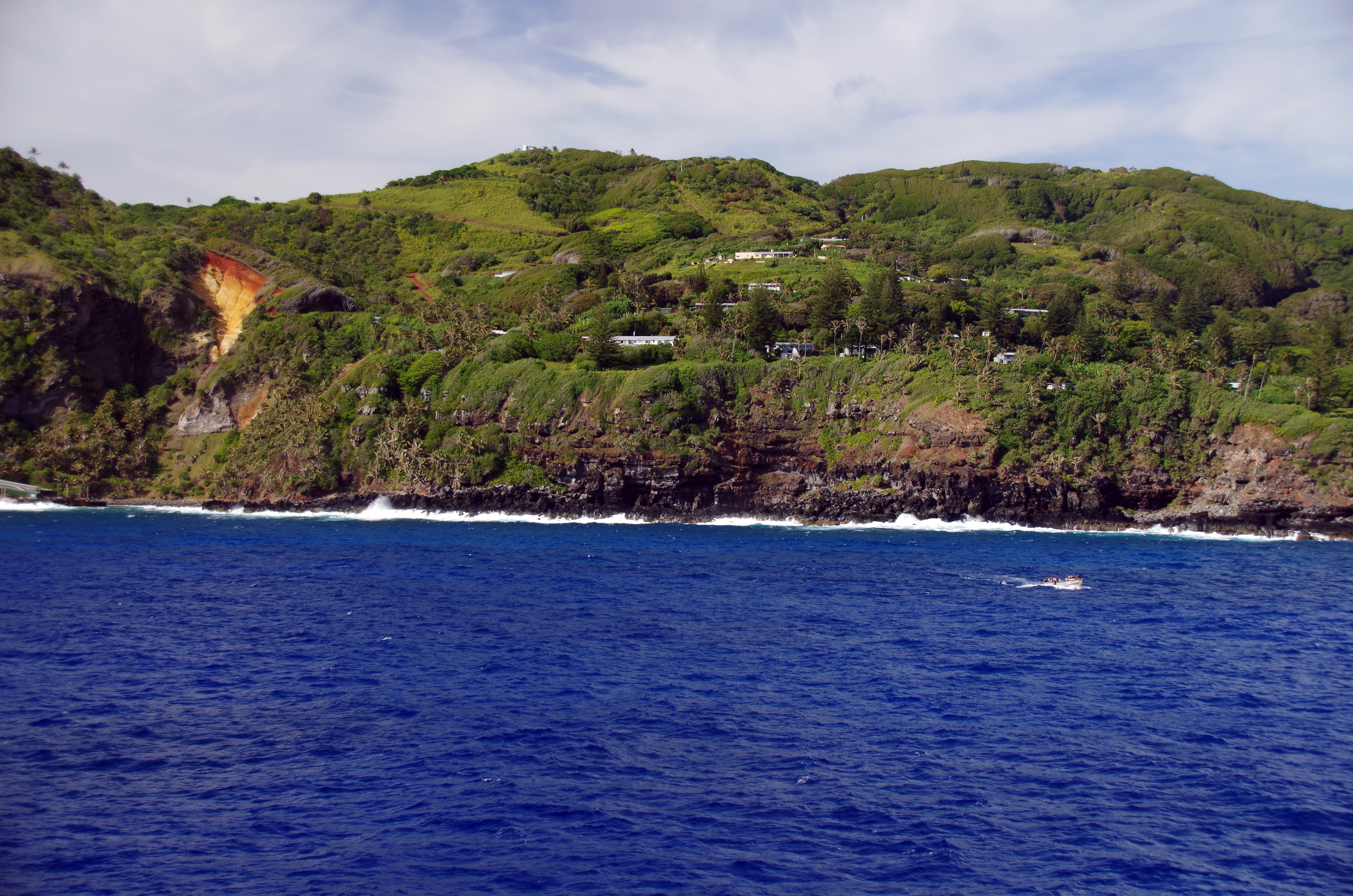
Where are the best places to visit in the Pitcairn Islands? Begin with Bounty Bay, Adamstown, the local museum and public historic places, then choose an appropriate nature walk or a guided excursion. The Pitcairn Islands are not a collection of easily connected resort beaches. Pitcairn itself is the only inhabited island, while Henderson, Oeno and Ducie lie far away and have exceptional conservation value rather than ordinary visitor infrastructure.
Pitcairn has no airport. The official 2026–27 sailing calendar describes voyages on the MV Silver Supporter between Mangareva in French Polynesia and Pitcairn, while cruise passengers can go ashore only when sea conditions and the captain's decision permit it. A headline promising ten attractions on a three-hour cruise stop would be misleading. Most readers should select a few places on Pitcairn and regard the outer islands as subjects for remote learning unless a highly specialised, legally authorised journey is actually arranged.
The island’s history begins long before the Bounty mutiny of 1789. Polynesian communities had occupied the wider region, and the later settlement included Tahitian women and men as well as British mutineers. Pitcairn is a living community with its own public institutions, not a romantic storybook location. This guide pairs its natural and historical places with honest advice about landing, physical difficulty, conservation, privacy and medical evacuation.
eduKate · Islands, history, ecology and careful travel
Choose your Pitcairn Islands reading route
Compare all ten · Landing and Adamstown · Hikes and water · Dark sky and protected islands · Plan your voyage
Travel reality: no airport, weather-dependent landing, limited medical resources and separately protected outer islands. Do not treat every place below as an ordinary excursion.


Ten places at a glance
The table distinguishes ordinary village landmarks from challenging trails and one remote protected outer island. Selection should be based on landing permission, actual conditions and local advice.
| Place | Reason to choose it | Practical limit |
|---|---|---|
| 1. Bounty Bay landing and the Hill of Difficulty | Arrival, ocean conditions and island access | Landing never guaranteed; steep route to town |
| 2. Adamstown Public Square and the Pamai Centre | Living village, small-island economy and civic facilities | Working community; services not open on demand |
| 3. Pitcairn Islands Museum and the Bounty cannon | Archaeology and documented island history | Museum opening and original artefact care |
| 4. Seventh-day Adventist Church and the Bounty Bible | Religious life, an heirloom and a living congregation | Worship etiquette and display arrangements |
| 5. Pitcairn cemetery and John Adams' grave | Families, mortality and histories beyond the mutiny | Active cemetery, solemn etiquette and sensitive records |
| 6. Eco Trail, Sailors Hide and Christian's Cave | Flora, oral tradition and a separate steep final climb | Easy initial trail does not mean easy cave access |
| 7. St Paul's Pool and the rocky north-east coast | Wave-carved tidal pool and demanding shore conditions | Swell, slippery rock and tide; swimming optional |
| 8. Down Rope petroglyph site | Ancient Polynesian rock markings below difficult cliffs | Local guide required; steep route and fragile archaeology |
| 9. Highest Point and Mata ki te Rangi dark-sky views | Island orientation and a recognised international dark-sky sanctuary | Steep paths, darkness and approved observation areas |
| 10. Henderson Island UNESCO World Heritage landscape (remote study) | A protected outer island, not an ordinary sightseeing landing | No routine public excursion; protected ecology and special authorisation |
1. Bounty Bay landing and the Hill of Difficulty
Why it belongs: Bounty Bay is where the journey to Pitcairn becomes real. There is no conventional airport or cruise terminal, and visitors arriving by sea rely on suitable weather and a transfer by local longboat or ship's tender. The small landing beneath high green slopes has a remarkably practical function. People, mail, food and equipment must be moved between vessels and the island, and the road above is known as the Hill of Difficulty for good reason. Standing here—if a lawful landing is possible—connects the familiar story of HMAV Bounty with the hard work of maintaining a present-day community.
The wider story: The famous mutiny took place in 1789 and the ship was eventually burned at Pitcairn in 1790. These facts attract many travellers, yet the bay has a much longer and more complex story than one ship. Polynesian people had occupied the island before the Bounty settlement, and the later community included Tahitian women and men as well as British mutineers. Early years involved profound violence and hardship; a romantic picture of isolation does not fairly represent the historical record. The harbour's modern importance is equally significant. It makes contact with the outside world possible, and residents must coordinate arrivals under conditions they cannot control.
Practical access and responsibility: Pitcairn's tourism authority explains that a cruise ship captain decides whether passengers can land, based on swell and sea conditions. If passengers cannot go ashore, local people may instead visit the ship with talks and crafts. Travellers who do land should follow arrival briefings and any transport arranged up the Hill of Difficulty. Do not walk into working longboat operations or assume the steep road is suitable for all mobility levels. An island visit can be worthwhile even when shore landing is impossible, but an advertised stop does not guarantee that ten attractions can be reached.
Learning prompt: Sketch a cross-section from ship to longboat, landing and Adamstown. Which steps depend on sea conditions, labour and safe vehicle access? Explain why a map's straight-line distance is a poor estimate of total travel time.
2. Adamstown Public Square and the Pamai Centre
Why it belongs: Adamstown is Pitcairn's only settled town, and the Public Square is a natural place to learn what everyday life looks like on this remote island. The small cluster of public institutions includes the community hall, church, museum and services that connect people with the world beyond the South Pacific. The Pamai Centre, established in 2020, houses businesses and services that a small community needs. This is not a 'lost village' waiting to be discovered: it is a functioning settlement whose residents make decisions about their own work, privacy and visitors.
The wider story: The tourism authority's virtual tour shows the post office, store, treasury and other facilities around Adamstown, while its local-service page explains the role of the Pamai Centre. The post office is known for distinctive Pitcairn stamps, and local artisans create carvings, woven items, jewellery, tapa and other products. A shipment's arrival may shape what the store has in stock, and mail can take weeks to leave or reach the island. These are material examples of geographical isolation, but they do not define everyone’s daily life. The community has schools, governance, families and relationships that extend well beyond travel brochures.
Practical access and responsibility: Treat the Square as a civic centre, not a tourist attraction with guaranteed all-day staffed exhibits. Ask before photographing residents, homes or children, and give workers space in the store and post office. If a cruise group arrives, local crafts may be offered on shore or aboard ship, but availability depends on the visit. Currency, telecommunications and merchandise arrangements should be confirmed locally rather than inferred from an old review. Visitors arriving for a multi-day stay should follow their host's guidance about services and public meetings.
Learning prompt: Make a list of four services—mail, food, transport and government—and explain which would be especially affected by a delayed ship. What local knowledge would you need before turning that observation into a statement about how residents live?
3. Pitcairn Islands Museum and the Bounty cannon
Why it belongs: The Pitcairn Islands Museum offers the context that visitors need before exploring stories attached to caves, graves and the coastline. It includes objects associated with Polynesian history and the Bounty era, including a cannon recovered from Bounty Bay. A cannon is tangible and memorable, but a museum's strength lies in explaining where objects came from, how they were identified and which questions remain. Rather than treating every relic as a proof of one popular legend, allow time to read the displays and understand the different cultures and periods represented.
The wider story: Pitcairn was not empty before the Bounty settlers arrived. Polynesian archaeological material connects it to earlier Pacific voyaging and exchange networks. Later objects, including naval items and community memorabilia, document a different sequence of contact and settlement. A bronze or iron cannon can indicate aspects of maritime technology but cannot tell you the beliefs or feelings of every person aboard the ship. Likewise, family heirlooms are meaningful evidence of community development, not a complete account of every family’s life. The museum makes clear why careful provenance is more reliable than the most dramatic version of a tale.
Practical access and responsibility: The official tourism guide locates the museum within walking distance of Adamstown's Public Square. However, on an island with a small population, opening and staffing may need arranging with local hosts rather than assuming fixed daily hours. Follow any instruction on photography and do not touch artefacts. If a short cruise stop leaves little time, a focused museum visit is generally preferable to a rushed climb toward multiple rugged sites. Reading one display properly can give a traveller more lasting knowledge than collecting several disconnected photographs.
Learning prompt: Choose a Polynesian-era object and an object associated with the Bounty. Write their documented dates or contexts separately, then identify two questions about earlier island history that a single artefact cannot settle.
4. Seventh-day Adventist Church and the Bounty Bible
Why it belongs: The Seventh-day Adventist Church in Adamstown is culturally significant because it has been part of Pitcairn's living community for generations. The island's famous Bounty Bible is displayed at the church, connecting an object associated with the eighteenth-century ship to later forms of religious life. Visitors interested in history can learn about the importance of books, worship and community institutions on a remote island, but the church should first be recognised as a place used by people rather than a museum stage.
The wider story: The Bible’s link with the Bounty period makes it a distinctive historical object. Yet the religious history of Pitcairn is not unchanged from 1790. Over the nineteenth century the community's traditions developed, and Seventh-day Adventist practices became established. The physical survival of a book does not prove that everyone living on the island shared the same beliefs at every point in time. A visitor should also remember that the first settlers included Tahitian women and men whose cultural and religious backgrounds cannot be collapsed into an exclusively British maritime story. Community life includes changes in language, faith and kinship.
Practical access and responsibility: Confirm whether the church is welcoming visitors and whether the Bible can currently be viewed. During worship services, residents’ practices should take precedence over tourist photography. Avoid handling a historic book and observe any conservation or display restrictions. Respect clothing, silence and the wishes of church staff. The building is close enough to the Square to be included on an unhurried village walk when permission is available, but a cruise itinerary should not advertise guaranteed private access to religious objects.
Learning prompt: Compare a historic book with a present-day meeting place. What can the age of a book reveal, and which facts about the community’s later religious history must come from records or personal testimony?
5. Pitcairn cemetery and John Adams' grave
Why it belongs: The cemetery close to Adamstown provides a reflective place to consider Pitcairn's past through individuals instead of focusing only on sensational episodes of the Bounty story. The grave of John Adams, a former mutineer who lived into the nineteenth century, is often singled out in travel materials. Nearby family memorials can tell other stories about relationships, illness, migration and the continuity of a small population. This remains a place of memory for residents, not simply a sightseeing collection of inscriptions.
The wider story: Pitcairn tourism identifies the graves of John Adams and members of his family among places visitors may see. Gravestones are strong evidence for names, dates and relationships where inscriptions survive. But they also reveal the limits of an archive. Some people, particularly those whose lives were marginalised in historic written accounts, may not have memorials that tell their stories in the same way. Pitcairn's early settlement included grave violence, exploitation and the lives of Polynesian people whose descendants helped shape the modern community. A careful visitor resists turning the cemetery into a simple family tree of celebrated mutineers.
Practical access and responsibility: Walk quietly, stay on recognised paths and do not sit on or climb graves. Avoid grave rubbings or handling fragile inscriptions. Photography may be inappropriate during memorial or family activity; ask your host if unsure. A good interpretation uses the cemetery in conjunction with the museum's documentary record rather than guessing dramatic stories from an epitaph. If a cemetery visit is not suitable for your group, learn its significance from the official virtual tour and locally published history.
Learning prompt: Record only what one gravestone explicitly states, then write a separate list of questions about the person's life. Explain why an inscription can be accurate without telling a complete social history.
6. Eco Trail, Sailors Hide and Christian's Cave
Why it belongs: The Eco Trail leads walkers through Pitcairn's plant life and intriguing rock formations toward Sailors Hide and the route associated with Christian's Cave. It is an appealing way to study the island's volcanic interior while learning how named places become linked to historical narratives. The official tourism guide distinguishes the gentle introductory route from the climb to Christian's Cave. That is a critical detail: a family choosing the accessible portion should not be promised an easy scramble into a cave high above the settlement.
The wider story: Sailors Hide is associated in local stories with sailors and with accounts of material made from ti plant roots. Christian's Cave takes its name from Fletcher Christian, one of the Bounty mutiny's best-known figures. Stories about why a person used a particular cave deserve careful examination alongside evidence from records and archaeology. The route also crosses vegetation containing native and endemic species, showing that a historic walking site is simultaneously a habitat. The flora is not an incidental green backdrop. Disturbing a plant to take a shortcut can cause damage even if the visitor has come mainly for history.
Practical access and responsibility: Ask a local guide about current path maintenance, surface, weather and the effort required for the final section. Wear sturdy shoes and do not assume all sections are suitable for wheelchairs or children. Stop before steep or exposed ground if that exceeds the group’s ability. Follow signs protecting vegetation and avoid entering unstable rock overhangs without guidance. A slow Eco Trail visit can be rewarding on its own, with the history of Christian's Cave explored through official interpretation rather than a compulsory ascent.
Learning prompt: Sketch two routes: the gentle Eco Trail and the distinct steeper climb. Discuss why both can lead toward a famous destination but present different levels of effort and risk. Add one plant observed and explain how its identification can be verified.
7. St Paul's Pool and the rocky north-east coast
Why it belongs: St Paul's Pool is one of Pitcairn's most striking natural places: a sea-carved pool surrounded by volcanic rock near the exposed coast. Its water can look exceptionally clear and inviting in photographs, and local tourism information describes swimming and snorkelling when the weather and sea allow. The critical phrase is when conditions allow. For a thoughtful visitor, the pool is also an opportunity to learn about the way waves carve stone and why a protected-looking pocket of water can still be connected to powerful ocean forces.
The wider story: Pitcairn has no long uninterrupted resort-beach coastline. Its rocky volcanic shores meet the open Pacific and are continually affected by swell, spray and erosion. A rock pool may hold marine organisms adapted to movement between wet and exposed conditions. At times a high wave can overtop an apparently sheltering wall, affecting currents inside. A photograph records one instant, not how water behaves through a tide cycle or during storms. The site’s geological value remains even when no one should swim. Visitor stories about past bathing outings should not become universal advice for young families.
Practical access and responsibility: Go only with local advice on the safe route, tide and current swell, particularly after rain or strong winds. Shoes with secure grip are necessary for uneven rock; the location may be unsuitable for people with limited mobility. Do not jump blindly into unfamiliar water, swim alone or enter during rough conditions. Do not touch, remove or disturb pool organisms. If a guide says access or swimming is unsafe, a public coastal viewpoint or virtual interpretation is the appropriate alternative.
Learning prompt: Draw a section through the pool showing the open ocean, surrounding rock and a possible overtopping wave. What data would you need to judge whether a swim is safe, beyond the colour of the water?
8. Down Rope petroglyph site
Why it belongs: Down Rope is one of Pitcairn's most significant archaeological landscapes because it contains petroglyphs associated with Polynesian people who used the island before the Bounty settlers. The name refers to a steep route toward a small beach beneath high cliffs. It is especially important for correcting an oversimplified version of Pitcairn history in which human life begins only with European mutineers. The earlier Polynesian presence belongs to a much wider network of Pacific settlement, voyaging, craft and exchange.
The wider story: The tourism authority describes the site at the base of an approximately 700-foot cliff and explicitly states that visitors may only go with a local guide because the route is difficult and potentially dangerous. These two pieces of information—archaeological significance and restricted access—must be presented together. Petroglyphs can preserve markings whose form and position are observable, but their exact meaning may remain debated. Scratching a carving to make it more visible or removing rock would permanently damage evidence. The archaeological setting and associated natural environment need protection even if visitor numbers are very small.
Practical access and responsibility: Do not go alone. Book an experienced local guide who confirms the path and weather, and accept that the excursion may be cancelled. Steep and loose ground makes the route inappropriate for many visitors, especially during a short cruise call. Do not handle carvings, apply chalk or water to markings or reveal unapproved access shortcuts. A traveller unable to take the route can learn from museum records and sanctioned photographs rather than assuming that physical entry is necessary to understand an archaeological site.
Learning prompt: Draw a known petroglyph shape from authorised interpretation rather than tracing the original stone. Label what is directly recorded and what remains an interpretation. Why is archaeological conservation inseparable from the meaning of the visit?
9. Highest Point and Mata ki te Rangi dark-sky views
Why it belongs: Pitcairn's high viewpoints offer a way to understand how the only inhabited island sits within a vast ocean. The slopes above Adamstown reveal the shape of the volcanic island, its narrow tracks and the relative position of the settlement and shoreline. After dark, the remoteness of the archipelago becomes apparent in another way: exceptionally dark skies. Pitcairn's Mata ki te Rangi, meaning Eyes to the Sky, is an officially recognised International Dark Sky Sanctuary encompassing the four islands.
The wider story: The DarkSky designation, approved in 2019, acknowledges the quality of the sky and the importance of limiting inappropriate artificial light. It covers more than the highest path or a single lookout. A starfield tells a story of Earth's position in space, but stargazing also depends on cloud, moonlight and the observer’s safety. High ground should not become an excuse to walk unfamiliar cliffs in darkness. The sanctuary includes the remote uninhabited islands, yet its recognition does not create a general tourism right to enter protected seabird habitats.
Practical access and responsibility: Choose a safe location recommended by a local host, ideally one that requires no difficult night-time route. Bring a suitable light that can be shaded or dimmed and use it carefully so other observers and wildlife are not disturbed. Ask about the current weather and avoid unsafe cliff paths at night. A guided daytime quad-bike tour may reach selected high viewpoints if conditions permit, but it does not guarantee a clear night or permit off-route driving. Stargazing from a secure settlement area is often safer and just as worthwhile.
Learning prompt: Compare a map of Pitcairn with what you can see from a day viewpoint, then make a simple night-sky log recording cloud cover, moon phase and a few identifiable stars. Which conditions influence observation without changing the positions of the stars?
10. Henderson Island UNESCO World Heritage landscape (remote study)
Why it belongs: Henderson Island belongs in a complete guide to the Pitcairn Islands group because it shows why the territory is internationally important beyond the inhabited island. Henderson is a raised coral island with largely intact natural ecosystems and endemic species found nowhere else. It was designated a UNESCO World Heritage property in 1988. Its very remoteness has helped preserve ecological features, so its importance should be explained through protected nature rather than sold as a beach excursion available with an ordinary Pitcairn ticket.
The wider story: Official Pitcairn tourism materials describe Henderson's endemic land birds and plant species and its role as a seabird sanctuary. The island also has evidence of earlier Polynesian occupation, showing that the island is not simply an empty place with no human history. The nearby Oeno and Ducie islands are distinct low atolls, also valuable as seabird and marine habitats; they must not be mistakenly presented as neighbourhoods of Adamstown. Island ecosystems can be badly affected by introduced rodents or plants, so biosecurity is an essential conservation issue. Scientific expeditions and specially organised local visits have occurred, but they are not a model for spontaneous leisure landing.
Practical access and responsibility: Do not plan to visit Henderson from a standard Pitcairn cruise call or infer that an ordinary berth on the Silver Supporter includes a tour of its outer islands. Any specialist trip would require explicit operator confirmation, environmental authorisation and appropriate vessel conditions. A traveller can use official research, UNESCO descriptions and the Pitcairn Islands Tourism virtual resources to study the island remotely. Respect the marine-protected area and do not promote wildlife disturbance or unauthorised shore landings as adventure opportunities.
Learning prompt: Compare three questions: what a shoreline photograph reveals, what an endemic-species survey establishes and what the UNESCO designation protects. Why does a place remain worth studying when ordinary physical entry is neither feasible nor appropriate?
Back to all ten · Planning guidance
How to plan the journey and choose what is realistic
A Pitcairn visit starts with the voyage, not a hotel reservation. The government-chartered MV Silver Supporter operates a published 2026–27 schedule with distinct passenger and freight voyages. A sample October 2026 timetable shows departures from Mangareva and several multi-day stays on Pitcairn, but dates can change and a timetable is not a reserved berth. Accommodation is limited and generally provided through local homestays or other small arrangements. Confirm lodging and the exact return voyage together. For cruise passengers, the captain controls landing, and a promised port call is not a promise of setting foot ashore.
The Government of Pitcairn Islands states that visitors for 14 days or less who arrive and depart on the same vessel may be able to complete a short-term immigration and biosecurity declaration on arrival, subject to requirements. Visits longer than 14 days require an advance long-term visa. Requirements can differ by traveller, and comprehensive medical and evacuation insurance is important. The UK government's Pitcairn advice also stresses the lack of an airport. These arrangements should be checked with the responsible authority, not assumed from a generic cruise description.
A safe, high-value route for a first visit
If the landing succeeds, begin at Bounty Bay and use authorised transport up the Hill of Difficulty. Spend time in Adamstown, choose the museum or church depending on opening, and visit the Square's working community services with respect. An extended stay can add the gentle part of the Eco Trail, a safe high viewpoint or a guided historic route. Fit a more demanding destination such as Down Rope or St Paul's Pool only if a knowledgeable local guide confirms conditions and your group has the necessary ability. Henderson belongs in a different, conservation-focused conversation rather than a normal day trip.
Essential visitor checks
- Check the official Silver Supporter schedule and obtain an actual berth confirmation before booking connecting travel to Mangareva.
- Confirm immigration, medical and evacuation insurance, biosecurity declarations and accommodation with the government and host.
- Do not presume a cruise ship will land passengers. The captain may decline a transfer because of surf or unsafe sea conditions.
- Choose a local quad-bike operator or supported walk for steep village roads; do not assume every visitor can manage the Hill of Difficulty.
- Treat museums, churches, cemetery and homes as living community sites. Ask before entering or photographing people.
- Down Rope must only be attempted with a guide; the Eco Trail and the steep final climb to Christian’s Cave are separate physical challenges.
- Do not swim in St Paul’s Pool without current local confirmation of safe conditions. Strong swell can overtop coastal rocks.
- Respect ecological and marine reserve rules. Henderson, Oeno and Ducie require specialist conservation and access planning, not improvised leisure landings.
Frequently asked questions
Can visitors fly directly to Pitcairn?
No. Pitcairn has no airport. Official visitor access is by ship, generally the government-chartered supply/passenger vessel from Mangareva or a cruise call with a suitable landing opportunity.
Is cruise-ship landing guaranteed?
No. The ship's captain makes the decision based on current sea and weather. Residents may instead visit the vessel with presentations and crafts if a landing is unsafe.
Can I see every place in a short cruise stop?
No. Even a successful landing requires a boat transfer and a steep ascent from Bounty Bay. Choose Adamstown and nearby heritage places; more demanding hikes need much more time.
Does the Bounty story describe Pitcairn's entire history?
No. Earlier Polynesian occupation, Tahitian settlers' lives, later community development and conservation are all part of the history. The museum is a useful starting point.
Can anyone enter Christian's Cave and Down Rope?
No. Christian's Cave involves a steep climb beyond the gentler Eco Trail, and the tourism authority says Down Rope is dangerous and requires a local guide.
Is St Paul's Pool safe for swimming on any day?
No. It is connected to an exposed ocean environment. Tide and swell can make swimming inappropriate; follow local advice rather than a still photograph.
Can ordinary tourists visit Henderson Island?
Not as a routine Pitcairn day trip. Henderson is a protected UNESCO World Heritage island with exceptional ecology. Any specialist visit requires legitimate arrangements, conservation compliance and suitable sea conditions.
What are the other Pitcairn Islands?
Pitcairn is inhabited; Henderson, Oeno and Ducie are remote outer islands. Oeno and Ducie are low atolls, while Henderson is a raised coral island.
Why is Pitcairn a dark-sky destination?
The entire four-island group is recognised as the Mata ki te Rangi International Dark Sky Sanctuary, reflecting its exceptionally dark skies and commitment to preserving them.
What should a traveller book first?
Start with the real ship berth, then local accommodation, insurance, entry eligibility and onward connections. A destination shortlist is not enough without the transport plan.
Build a reliable travel notebook
A practical family notebook separates what was directly observed from a source-supported explanation and a remaining question. At Bounty Bay, record the steep relation between landing and settlement. In the museum, distinguish an original artefact from a display model. Along the Eco Trail, identify plants using labels or a guide rather than guessing. For Henderson, state plainly that your understanding comes from UNESCO documents or scientific records, not a personal observation. This style of learning avoids pretending that physical proximity proves everything.
Use the voyage to practise practical mathematics. The sea distance from Mangareva is only one component of a journey that also involves flights, ship schedules, weather windows and transfers. Why can a relatively short map distance translate into many days of travel? Show the missing variables before making an estimate. The same habit of transparent reasoning is central to eduKate’s Secondary 1 Mathematics Tutor Clementi | Small Groups Tutorials.
Continue in the eduKate Pitcairn collection
Top 10 Things to Do When Visiting and Touring Pitcairn Islands · Top 10 Things to Learn When Visiting and Touring Pitcairn Islands · World Travel Hub
Official references and image credit
Sources reviewed 20 October 2026 (Singapore time). Official heritage and operator descriptions establish background, not live sea conditions or confirmed booking slots. The featured photograph is an archival 2017 image with credited reuse rights; it is not evidence of present access.
- Pitcairn Islands Tourism — local services, walks, pools and heritage
- Pitcairn Islands Tourism — Virtual Tour
- Pitcairn Islands Tourism — 2026–27 passenger ship timetable
- Pitcairn Islands Tourism — booking a berth
- Pitcairn Islands Tourism — cruise landing conditions
- Government of the Pitcairn Islands — immigration and visitor insurance
- UK FCDO — Pitcairn entry requirements
- Pitcairn Islands Tourism — the four islands and Henderson ecology
- UNESCO — Henderson Island
- Pitcairn Islands Tourism — Mata ki te Rangi dark-sky sanctuary
- Pitcairn Islands Tourism — Pitcairn marine protected area
- Wikimedia Commons — Adamstown photo by Balou46, 2017
- Creative Commons Attribution-ShareAlike 4.0