
Elephant Island, in the South Shetlands near the Antarctic Peninsula, is a place where difficult geology, wildlife and the 1916 Shackleton expedition intersect. His crew reached it by lifeboat on 15 April 1916; six later set out in the James Caird, and twenty-two men were rescued by the Chilean Yelcho on 30 August. Antarctic Treaty site guidelines also show why Point Wild is not an ordinary public beach.
Follow ten lessons from location and glacial hazards through surviving the expedition, the rescue, historic photography, wildlife and visitor responsibilities. Each includes a practical activity and answer check. A worked example, one-hour study plan, bilingual vocabulary, ten questions and the underlying evidence appear below.
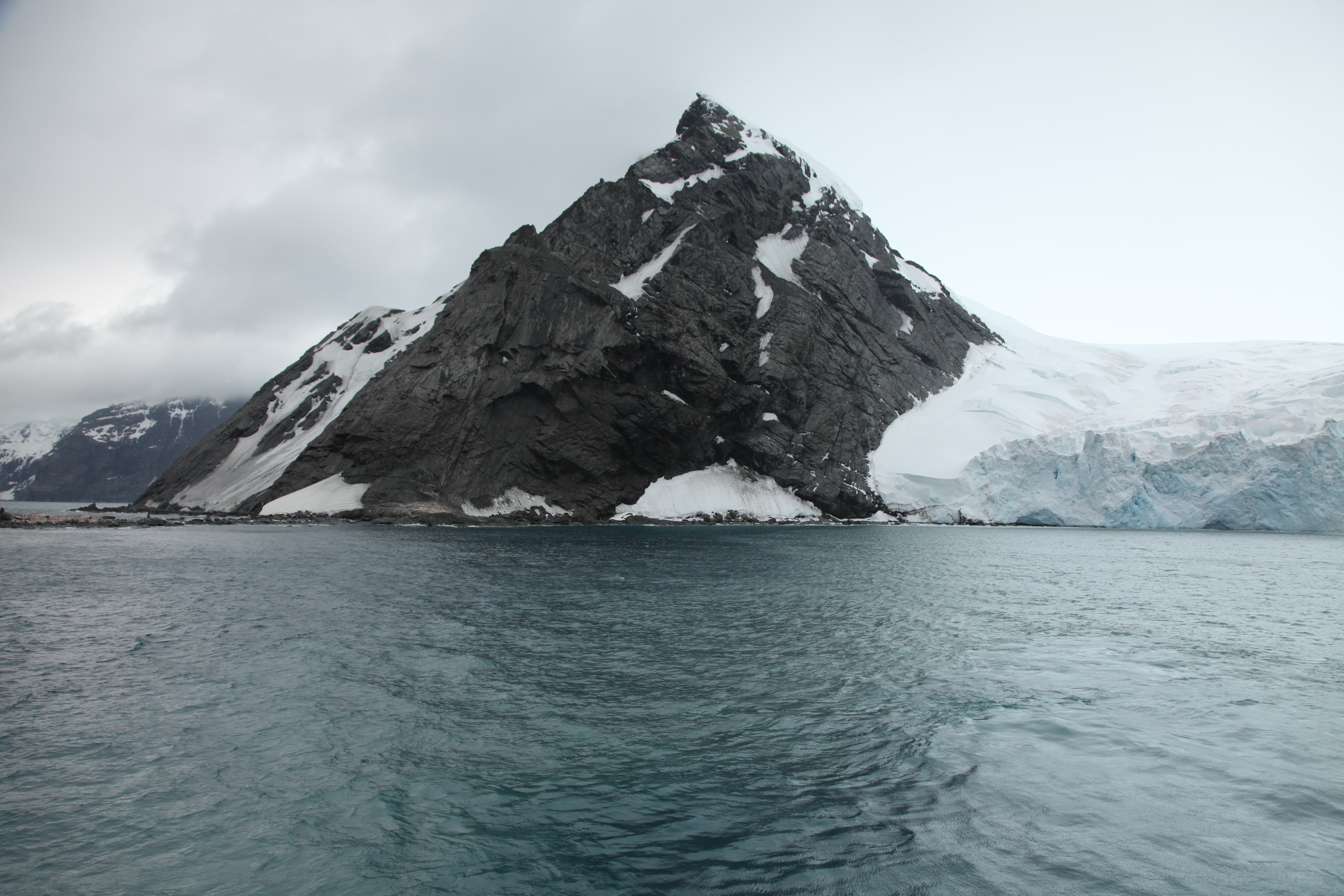
Featured photograph: Point Wild, Elephant Island, by Liam Quinn, 22 January 2011, Wikimedia Commons, CC BY-SA 2.0. This is a modern landscape record, not an image of the 1916 expedition.

Choose a route: Fast facts · Ten lessons · Worked example · Family plan · Vocabulary
Quick facts for readers
| Question | Reliable starting answer |
|---|---|
| Where? | South Shetland Islands, Antarctic Treaty area, near the peninsula. |
| Landscape? | Steep glaciers, cliffs and a narrow rocky Point Wild coast. |
| Historic landing? | Shackleton’s men reached Elephant Island on 15 April 1916. |
| James Caird? | Six set sail toward South Georgia on 24 April 1916. |
| Rescue? | Twenty-two rescued aboard Chilean Yelcho, 30 August 1916. |
| Wildlife? | Chinstrap penguins and other seabirds, seals and lichens. |
| Access? | Often impossible landings, visitor site limits and national permits. |
Contents: ten things to learn
1. Locate Elephant Island at the edge of the South Shetlands
2. Discover why the narrow coastline is so difficult
3. Follow the Endurance story without compressing its dates
4. Understand how the men adapted their boat into a shelter
5. Follow the James Caird voyage and the six-person departure
6. Give Frank Wild and the waiting men their proper place
7. Recognise the Yelcho rescue and Captain Luis Pardo
8. Learn how an archival photograph can have a misleading title
9. Notice chinstrap penguins, seals and lichens at Point Wild
10. Read the 2012 seabed survey and modern visitor rules
Worked maths · Family study · Glossary · FAQs · Sources · Keep learning
1. Locate Elephant Island at the edge of the South Shetlands
Elephant Island sits near the northeastern end of the South Shetland island chain, separated from the Antarctic Peninsula by cold Southern Ocean waters. The Antarctic Treaty visitor-site record for Point Wild places the famous promontory on its north coast. An island in the Antarctic Treaty area is not automatically part of an ordinary country or connected to a public ferry service.
The UK Royal Navy’s 2012 survey report locates the island approximately 1,255 kilometres from South Georgia and around 885 kilometres from Cape Horn. These are helpful indicative geographic distances from a dated report, not the length of a safe sailing route. Open-water travel in this region also depends on sea state, ice, navigation, authorisation and changing weather.
Start with a map of the Antarctic Peninsula, then zoom in on the South Shetlands and Elephant Island. Mark a simple line to South Georgia to begin understanding Shackleton’s voyage. A modern satellite outline cannot reveal the human experience of 1916, and a historic route description is not a 2026 navigational chart.
Try this: Mark Elephant Island, the peninsula and South Georgia. Explain the difference between straight-line distance and a voyage route.
Is Elephant Island on mainland Antarctica?
No. It is an island in the South Shetlands, near but separate from the Antarctic Peninsula.
← Previous · Contents · Next →
2. Discover why the narrow coastline is so difficult
The Point Wild visitor guidance describes steep tidewater glaciers, cliffs and grounded icebergs along the coast. Only small rocky or gravelly points break the steep shoreline. Those features help explain why a small area can be historically important and still be extraordinarily difficult to reach safely.
Glacier ice meeting the sea can break away or calve. The resulting pieces can create hazards for a small boat, as can underwater rocks and rapidly changing swells. The site’s management guidance warns that boat landings are often impossible in local conditions. That is different from saying every day is equally dangerous or asserting a precise risk without evidence.
The Liam Quinn photograph from 22 January 2011 depicts coastal ice and dark rock; it is a powerful geographical clue but not a real-time safety assessment. A class can annotate visible glacier, water and rock separately, then list the additional observations required before any legitimate field operation.
Try this: Draw a coastline cross-section with tidewater ice and submerged rocks; clearly write ‘not for navigation’.
Can a calm-looking photo guarantee a safe landing at Point Wild?
No. A photograph cannot establish current ice movement, wave conditions, hazards or authorisation.
← Previous · Contents · Next →
3. Follow the Endurance story without compressing its dates
Ernest Shackleton’s Imperial Trans-Antarctic Expedition became trapped by pack ice in the Weddell Sea, and the ship Endurance was lost in 1915. The men crossed ice and used lifeboats to reach Elephant Island in April 1916. The Royal Collection’s original expedition exhibit dates their first landing to 15 April 1916. That sequence is important: the crew did not sail from a working port straight to Point Wild.
The initial spot seemed safer than the sea ice, but was too close to the high-water mark. They tried different places and shelters before establishing a more workable camp. This history teaches geography as much as determination: tides, exposed shores and limited materials controlled what was possible.
Write a chronology using four verbs: ship trapped, ship lost, lifeboats used and island reached. If a photograph is undated, do not use its apparent weather to claim a particular expedition day was stormy or calm. Historic testimony and location-specific evidence are stronger than imaginative captions.
Try this: Make a two-year timeline and explain why the 1915 ship loss and 1916 landing are different events.
Did the 1916 group arrive at Elephant Island on an intact Endurance?
No. They reached it by lifeboat after the ship’s loss.
← Previous · Contents · Next →
4. Understand how the men adapted their boat into a shelter
The Royal Collection historical notes describe how the castaways used upturned lifeboats to build a camp on Elephant Island after their first landing proved poorly placed. It was a grim survival arrangement, not a comfortable base. Shelter design depended on available materials, wind, tidal height and insulation.
The account describes smoke from burning blubber, muddy ground and limited food. Students can examine such details without romanticising hardship or offering untested survival instructions. The useful historical questions concern resource scarcity and teamwork: what could be reused, what needed to remain dry, and how did conditions differ from the ship’s original shelter?
A boat used as a roof may be creative engineering, yet an old reconstruction drawing is still an interpretation of a specific historical event. Photograph captions and museum descriptions should be checked against the primary record rather than being treated as a building manual.
Try this: Draw an annotated historical shelter cross-section, marking it a reconstruction and identifying the evidence source.
Was the boat shelter an ordinary permanent Antarctic research station?
No. It was an improvised temporary refuge for shipwrecked expedition members.
← Previous · Contents · Next →
5. Follow the James Caird voyage and the six-person departure
On 24 April 1916, Shackleton and five others left Elephant Island aboard the small lifeboat James Caird, heading for South Georgia to seek help. The Royal Collection’s corrected photograph catalogue explicitly identifies that departure date. Six men sailed, leaving twenty-two companions behind.
Their crossing is often described as extraordinary navigation, but it should not be turned into a recommended activity for visitors. Sea state, vessel preparation, navigation and specialised expedition conditions are beyond what a classroom route line can demonstrate. The Royal Navy’s historical summary also distinguishes the ocean crossing from the later rescue.
In a map exercise, connect Elephant Island to South Georgia. Then ask why the direct distance is not automatically the voyage’s actual mileage. Winds and currents affect routes, and there are many obstacles between a line on paper and a completed passage.
Try this: Write 28 = 6 + 22 beneath a map, and explain why the two groups faced different challenges.
How many expedition members left in the James Caird?
Six, including Shackleton; twenty-two remained at Elephant Island.
← Previous · Contents · Next →
6. Give Frank Wild and the waiting men their proper place
While the James Caird travelled toward South Georgia, Frank Wild led the twenty-two people left behind at Elephant Island. The rescue site’s name, Point Wild, remembers his part in the story. The 2012 Royal Navy report explicitly connects this location with Shackleton’s deputy.
It is too simple to tell the story as if only the six men at sea mattered. The camp also required organisation, sharing scarce resources, watching conditions and maintaining hope without knowing when a rescue could arrive. Personal accounts deserve careful citation, and not every detail repeated in later storytelling is equally well documented.
Students can compare the two groups without ranking who was more heroic. The research questions are practical: which events happened at sea, which happened at the camp, what information could each group have, and what sources make that account credible? This approach avoids fictitious diary entries masquerading as first-hand evidence.
Try this: Create a two-column 1916 timeline labelled ‘James Caird party’ and ‘Point Wild party’.
Was Frank Wild among the six who sailed to South Georgia?
No. He led the men who remained on Elephant Island.
← Previous · Contents · Next →
7. Recognise the Yelcho rescue and Captain Luis Pardo
The twenty-two men at Elephant Island were rescued on 30 August 1916 by the Chilean vessel Yelcho, commanded by Captain Luis Alberto Pardo. The Antarctic Treaty site’s historical description explicitly remembers this part of the expedition and identifies a monument commemorating Pardo.
The Royal Collection also documents the final rescue after the camp’s long wait. Saying “Shackleton rescued all his men” is a familiar shorthand, but accurate history names the Chilean ship, its captain and the survivors. An event is often the result of many decisions and people, not just one well-known name.
At Point Wild the commemorative bust, monolith and plaques are part of the designated historic site. They should be understood as preserved memorials, not props to climb or souvenirs to touch. Respect for the Chilean rescue contribution and the landscape makes a more complete account than an explorer-only narrative.
Try this: Write a rescue caption naming date, ship, captain and the number left on Elephant Island.
Which ship took the stranded group from Elephant Island in August 1916?
The Chilean vessel Yelcho, commanded by Captain Luis Alberto Pardo.
← Previous · Contents · Next →
8. Learn how an archival photograph can have a misleading title
The Royal Collection’s catalogue for Frank Hurley’s photograph RCIN 2580123 explains an instructive surprise: the photograph entitled “Sir Ernest Shackleton arriving at Elephant Island” actually depicts the James Caird departing on 24 April 1916. Hurley did not photograph the 30 August rescue and later renamed a different image to tell the story.
This makes an excellent media-literacy lesson. Photographs capture light at a moment; titles can be created or changed afterwards. A caption may be mistaken, edited for narrative effect or divorced from an original catalogue. Always ask what appears in the actual image, when it was made, who took it and what a trusted archive says.
For schoolwork, avoid reproducing an historic photograph without checking both its provenance and reuse rights. Our featured image is a separate, openly licensed photograph by Liam Quinn from 2011; its different date should not be mistaken for evidence that a 1916 scene looked exactly the same.
Try this: Make an ‘image says’ / ‘catalogue says’ card for the mislabelled Hurley image, without inventing a rescue photograph.
Does a photo title always establish the event it shows?
No. The Royal Collection identifies a famous Elephant Island photo with a misleading later title.
← Previous · Contents · Next →
9. Notice chinstrap penguins, seals and lichens at Point Wild
The Point Wild visitor-site guidance identifies breeding chinstrap penguins, Antarctic terns and kelp gulls. It also lists fur seals using the area, other marine mammals offshore, and patches of lichens. The same narrow point that holds historical importance is therefore a living ecological site.
A penguin colony must be observed without blocking routes between nesting ground and the sea. A dramatic photograph may show many individuals, but changes in breeding numbers need repeat counts with consistent methods. Mosses and lichens are also vulnerable to trampling, particularly where land without ice is scarce.
Give a child three evidence questions: which animals breed here, which merely visit or haul out, and which species need further observation to confirm breeding? Those categories appear explicitly in the official guidance. Learning to distinguish them is a stronger outcome than producing a photo checklist.
Try this: Make a chart with ‘confirmed breeder’, ‘seasonal visitor’ and ‘further evidence needed’.
Does a nearby seal automatically count as a breeding animal at Point Wild?
No. Haul-out, nearshore presence and confirmed breeding are different observations.
← Previous · Contents · Next →
10. Read the 2012 seabed survey and modern visitor rules
The UK Royal Navy reported hydrographic surveying at Point Wild in 2012 to improve knowledge of tides, shoreline and water depth. Scientific chart-making combines echo-sounder data with observations and corrections. A seafloor survey from 2012 can teach methods and history, but present operations require suitable charts and current conditions.
The Antarctic Treaty Point Wild site guidelines describe exceptional landing limitations: conditions often prevent landing; if going ashore, small closely guided groups of up to fifteen are specified, with no free-roaming area. The guidelines also call for wildlife rest periods and prohibit disturbing historic artefacts. A limit on ship passengers is not permission for that number to land at once.
For UK-organised activity, the British government’s Antarctic permit guidance, updated March 2026 confirms that appropriate authorisations are required. Equivalent processes apply under other Treaty nations. No historical landing, guide or tour brochure can guarantee an authorised, safe modern visit. The responsible choice for many readers is a remote learning project.
Try this: Write a one-sentence rule distinguishing ‘site guidelines’ from an actual permit and current weather clearance.
Does a published Point Wild visitor guideline guarantee a particular ship can land?
No. Legal authorisation, wildlife protection, weather and operational safety still apply.
← Previous · Contents · Next →
Worked example: a 28-person expedition and two distinct groups
Historical counts, classroom arithmetic. At the moment the James Caird sailed, the twenty-eight men were divided into six aboard the boat and twenty-two remaining on the island. What percentage took the boat, and what share stayed at Point Wild?
The boat party accounted for 6 ÷ 28 × 100 ≈ 21.4%. The waiting party accounted for 22 ÷ 28 × 100 ≈ 78.6%. Rounded to one decimal place, the two percentages add to 100%.
These figures describe the number of expedition members in each group at a particular stage; they are not probabilities of survival, average voyage time or a ratio of ships to boats. You cannot use 78.6% to claim that a waiting individual had a 78.6% chance of rescue.
For a chronology exercise, 15 April to 30 August 1916 spans 137 elapsed days using ordinary date subtraction. The exact number of days spent at the final Point Wild camp differs because the first arrival and subsequent moves are different events. The historical expedition record helps you preserve that distinction.
A one-hour family or classroom learning plan
Begin with fifteen minutes mapping Elephant Island and South Georgia. Explain what the Royal Navy’s reported distances can and cannot tell you about sailing conditions.
Use the next fifteen minutes to assemble four dated historical cards: the 1915 ship loss, April 1916 landfall, 24 April James Caird departure and 30 August rescue. Name Frank Wild, Shackleton and Captain Pardo in the proper parts of the story.
Spend fifteen minutes examining the Royal Collection’s mislabelled Hurley photograph. Ask why an apparently authoritative caption may still need interpretation. Compare it with the clearly dated 2011 featured landscape photograph.
End with the percentage exercise, then read Point Wild’s visitor guideline. One learner writes a conservation rule and another explains why an official site plan is not permission to land.
English–Simplified Chinese vocabulary
| English | 简体中文 | Meaning here |
|---|---|---|
| Archipelago | 群岛 | Group of islands. |
| Pack ice | 浮冰群 | Sea ice formed into extensive fields. |
| Tidewater glacier | 入海冰川 | Glacier ending at the sea. |
| Calving | 崩解 | Breaking of ice from a glacier or iceberg. |
| Lifeboat | 救生艇 | Small vessel used in a maritime emergency. |
| Point Wild | 怀尔德角 | Headland on Elephant Island commemorating Frank Wild. |
| High-water mark | 高潮水位线 | Upper reach of water under relevant tidal conditions. |
| Shelter | 庇护所 | Structure giving some protection from exposure. |
| Hydrographic survey | 水文测量 | Measurement supporting nautical charts and marine understanding. |
| Echo sounder | 回声测深仪 | Device measuring water depth with reflected sound. |
| Provenance | 来源沿革 | Documented origin and history of evidence. |
| Artefact | 历史遗物 | Object preserved for its historic significance. |
| Chinstrap penguin | 帽带企鹅 | Penguin species breeding in the region. |
| Permit | 许可证 | Formal permission for a specified activity. |
Frequently asked questions
Where is Elephant Island?
In the South Shetland Islands northeast of the Antarctic Peninsula.
Why is it famous?
It sheltered Shackleton’s stranded Endurance expedition in 1916.
When did the men land?
The Royal Collection dates their arrival by lifeboat to 15 April 1916.
When did Shackleton leave in the James Caird?
24 April 1916, with five other men.
How many men stayed behind?
Twenty-two, led by Frank Wild.
Who rescued them and when?
Captain Luis Alberto Pardo aboard the Chilean Yelcho on 30 August 1916.
Is the famous Hurley ‘arrival’ photo actually the rescue?
No. The Royal Collection says it depicts the James Caird departure, not the rescue.
Are penguins breeding at Point Wild?
The Antarctic Treaty guidelines identify chinstrap penguins and certain seabirds as confirmed breeders.
Are tourist landings guaranteed?
No. Landing is frequently impossible, site visits are constrained and the operator must have appropriate authorisation.
Can visitors handle the Pardo monument or historical remnants?
No. Historic artefacts should not be touched or removed.
Primary sources and further reading
Use contemporary visitor and permitting rules for any actual proposal. The photographs and archival sources below document distinct historical dates.
Antarctic Treaty Secretariat: Point Wild visitor site and historic monument HSM 53
UK Foreign Office: Antarctic visits and permits, updated March 2026
Royal Collection: Elephant Island 1916, camp life and Chilean rescue
Royal Collection: Frank Hurley photograph with corrected 24 April caption
UK Ministry of Defence, 2 March 2012: Point Wild hydrographic survey
Liam Quinn, 2011: Point Wild photograph, CC BY-SA 2.0
Keep learning about Antarctic islands
South Shetland Islands: volcanoes, science and visitor rules
South Georgia and South Sandwich Islands
Antarctica: broader learning guide