
The South Shetland Islands are an Antarctic archipelago where geology, wildlife, research and carefully controlled visits meet. Deception Island includes a flooded volcanic caldera; other parts of the chain contain glaciers, seabird breeding sites and research facilities. Some authorised visitors may reach specified places, but Antarctic environmental and visitor rules are essential and a photograph is not permission to land.
Use these ten lessons to make sense of the islands before an approved voyage or entirely from home. Each lesson explains what can be learned, what the evidence does not establish, and a simple activity. Start with the map, then choose volcanic history, wildlife, monitoring or the Antarctic Treaty. A worked example, bilingual vocabulary and family plan follow.
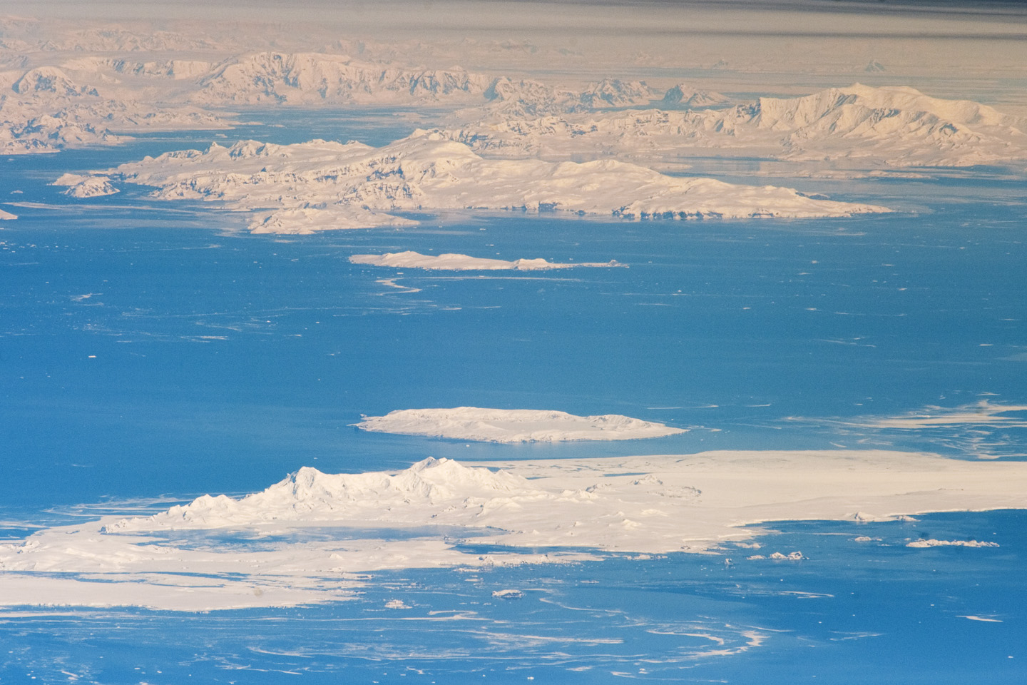
Featured image: South Shetland Islands and Antarctic Peninsula, photographed by NASA ISS Expedition 29 crew on 4 October 2011. Public-domain image information at Wikimedia Commons. The photographic viewpoint is strongly oblique, so apparent distances are not a chart.

Choose a route: Quick facts · Ten lessons · Worked example · Family learning · English–Chinese vocabulary
Quick facts for your study
| Question | Answer |
|---|---|
| Where? | North of the Antarctic Peninsula, across the Bransfield Strait. |
| Most distinctive volcanic example? | Deception Island, with a flooded caldera and documented eruptions. |
| Common learning subjects? | Geology, penguin colonies, glaciers, research history and conservation. |
| Can tourists go anywhere? | No. Antarctic Treaty, national and site-specific guidance apply. |
| Relevant legal geography? | Within the Antarctic Treaty area south of 60°S. |
| Best evidence? | Scientific records, Antarctic Treaty visitor guidelines, mapped sites and dated images. |
Contents: ten things to learn
1. Place the island chain north of the Antarctic Peninsula
2. Use Deception Island to understand a flooded volcanic caldera
3. Understand why the island has scientific instruments
4. Read whaling and station history without treating ruins as props
5. Notice how seabird colonies make coastal space valuable
6. Use visitor-site guidelines as a lesson in conservation
7. Separate visible sea ice, glaciers and seasonal change
8. See international Antarctic science as a shared framework
9. Use environmental assessment rather than assumptions about tourism
10. Make a better explanation with evidence and uncertainty
Worked example · Family plan · Vocabulary · Questions · Sources · Keep learning
1. Place the island chain north of the Antarctic Peninsula
The South Shetland Islands lie off the northern tip of the Antarctic Peninsula. In a regional map, find Drake Passage, the peninsula, the South Shetlands and the Bransfield Strait. A single shaded area can make the geography appear simple, but the archipelago contains several islands, straits and very different landforms. The NASA astronaut photograph shows Livingston and Deception islands in a wider polar setting.
Start with three map scales. A globe tells you where Antarctica sits relative to South America. A regional map distinguishes islands from the peninsula. An island-level map shows the coastline and a potential science or visitor site. Each is accurate for some questions and too coarse for others. A scenic photograph from space is not a vessel chart, and apparent distance is affected by the camera’s oblique view.
The Antarctic Treaty area includes land and ocean south of 60 degrees south latitude. The Norwegian Polar Institute’s treaty explanation is a useful source for understanding why geographical latitude matters in law and operations. A map of islands alone does not explain the rights, environmental duties and national authorisation procedures of those travelling there.
Try this: Draw a map with a north arrow and label the peninsula, Bransfield Strait and island group. Explain the map scale you chose.
Are the South Shetland Islands the same landmass as the Antarctic Peninsula?
No. They form a separate archipelago off the peninsula.
← Previous · Contents · Next →
2. Use Deception Island to understand a flooded volcanic caldera
Deception Island is among the most distinctive islands in the chain because volcanic activity and the sea have shaped its landscape. The Antarctic Treaty management measure describes the island’s natural, scientific, historic and educational values and identifies important episodes of eruption and unrest. Its central flooded caldera is often called Port Foster.
Explain a caldera as a large volcanic depression formed through processes associated with a volcano’s structure and eruptions. Do not use a model of an ordinary circular lake as if it settles exactly how every depression formed. At Deception Island, geological field observations, rock descriptions, maps and monitoring help reconstruct the particular sequence. The active volcanic context is important for visitor safety as well as physical geography.
A comparison between photographs separated by decades may show changes after an eruption, but it also needs matched viewpoints. Snow cover, camera angle and weather can produce apparent differences without a geological event. For a useful caption, distinguish what a dated photograph visibly shows from the dated eruption history supplied by scientific and management records.
Try this: Draw a conceptual volcano cross-section with a depression and seawater. Label it as a model, not a measured cross-section.
Does a calm-looking bay prove that its underlying volcanic system is inactive?
No. Surface appearance cannot establish volcanic activity or current hazard.
← Previous · Contents · Next →
3. Understand why the island has scientific instruments
The Antarctic Treaty guidelines for Telefon Bay describe scientific seismic monitoring instruments and ask visitors not to approach or interfere with marked equipment. These instruments help researchers observe processes that cannot be inferred from one beach photograph. Measurements need location, date, calibration and interpretation.
A seismic instrument records ground motion; it does not by itself predict the exact time of a future eruption. Monitoring networks combine data and expert analysis. Compare this with a school experiment: one temperature reading describes a moment, while a planned series can help reveal change. It is important not to exaggerate either the certainty or the meaning of a single measurement.
Scientific equipment may sit in an area that appears visually unremarkable. For visitors at approved sites, leaving it untouched is part of the scientific method: the measurements depend on continuity and an undisturbed environment. For students at home, historic monitoring descriptions offer a way to learn why location and careful instruments matter.
Try this: Write two statements, one about what seismic instruments measure and one about a question they cannot answer alone.
Does a seismic station supply a guaranteed eruption date?
No. It provides observations to be interpreted with other evidence and uncertainty.
← Previous · Contents · Next →
4. Read whaling and station history without treating ruins as props
The British Antarctic Survey’s station history records the former station at Whalers Bay, Deception Island, its scientific roles and evacuations linked to volcanic eruptions in 1967 and 1969. Buildings once adapted from whaling infrastructure were later used for research. One physical landscape therefore contains overlapping histories of industry, science and hazard.
An old hut or industrial structure may look adventurous in a photograph. A careful guide asks who worked there, what their duties were, and how the site changed over time. The word ‘abandoned’ describes a later condition; it does not make the people and work unimportant. Source dates distinguish a building’s use from the date its remains were photographed.
A heritage site is not an invitation to handle objects, enter unsafe structures or collect remnants. Protection has a cultural purpose as well as an environmental one. The useful educational task is to connect an archival record with an observed structure and explain what the two together establish, not to invent a scene that was never documented.
Try this: Make a three-column timeline labelled whaling, research and eruption-related evacuation. Add only dates supported by records.
Can an undated photograph of ruins establish when a station was operating?
No. An operational timeline needs documentary evidence.
← Previous · Contents · Next →
5. Notice how seabird colonies make coastal space valuable
Penguins use South Shetland beaches and slopes for breeding and movement, including colonies on Deception Island. The Baily Head visitor guidance explains how people and penguins share narrow sections of shore. Its instructions are designed to avoid obstructing bird movement and disturbing breeding groups.
Think about a penguin ‘highway’ as a repeated path between the sea and a colony, not a road constructed by humans. A bird needs to reach food at sea and return to land for particular stages of reproduction. A barrier on a short path can have consequences beyond the place where the person stands.
Wildlife photographs should record what is visible and when it was observed. Adults standing in a group, active nests and fledged chicks represent different kinds of evidence. A dramatic colony photograph can communicate the density of birds, but a scientific population trend needs a consistent monitoring method and seasonal context.
Try this: Draw a line from a penguin colony to the sea and show why a visitor crossing the route may matter.
Is a large flock in one photograph proof of annual breeding success?
No. Success needs appropriate repeat observations of nests, chicks or fledging.
← Previous · Contents · Next →
6. Use visitor-site guidelines as a lesson in conservation
Antarctic visitation is not one unrestricted invitation to wander. Different sites have site-specific plans. The Baily Head guidelines specify close supervision in groups of no more than fifteen for relevant routes and a wildlife rest period. The Telefon Bay guidance gives other site-specific precautions, including avoiding marked seismic instruments and fragile vegetation.
These requirements cannot be transferred mechanically to every beach on every South Shetland island. A rule has a location, a purpose and a current version. Environmental limits are part of the experience of understanding Antarctica, not minor footnotes that can be ignored once a cruise advertisement appears.
Use a hypothetical question: a guide leads fifteen people along an approved route but sees that penguins are changing behaviour. Does compliance with a group size alone guarantee the visit is appropriate? No. The general Antarctic visitor guidance requires avoiding harmful wildlife interference. Operators and guides must adapt or withdraw in response to actual conditions.
Try this: Create a table of three activities: walking, photographing and approaching equipment. Match each to an appropriate source and reason.
Does a small group automatically make every landing permitted or harmless?
No. Rules, wildlife response and location-specific authorisation still matter.
← Previous · Contents · Next →
7. Separate visible sea ice, glaciers and seasonal change
Sea ice forms from seawater; glaciers are land-based ice that moves under gravity. Both can appear in polar photography but have different origins and dynamics. Around the South Shetlands, seasonal sea ice and glaciers influence coastal access and the surroundings in which wildlife feeds. Their presence at one date does not prove a long-term trend.
An image of extensive snow might be from winter or from a particular storm. Comparing it with a summer image cannot by itself quantify glacier retreat. A scientific comparison requires consistent definitions, mapped boundaries, dates, measurement uncertainty and suitable repeated observations.
Try a model on paper: outline an island glacier on one sheet and seasonal sea ice around the same island on another. Then write what would need measuring to test change in each. This keeps a photograph from turning into a climate claim larger than the evidence can support.
Try this: Explain in two sentences the difference between sea ice and a glacier, using the right source of water.
Are sea ice and glacier ice interchangeable indicators?
No. Their physical origins and measurements differ.
← Previous · Contents · Next →
8. See international Antarctic science as a shared framework
The Antarctic Treaty entered into force in 1961 and establishes principles of peaceful use, scientific cooperation and arrangements concerning territorial claims. The Treaty does not make Antarctica an ordinary independent country. Research stations and expeditions are subject to the Treaty framework and the applicable national laws and authorisations.
The South Shetlands contain scientific facilities used by different national programmes. A photograph of one station cannot represent every operator or the whole region. Ask which programme is responsible for each station, what it studies, and when the station is staffed. Scientific cooperation can involve exchanging observations, methods and logistical assistance.
For political geography, avoid describing overlapping territorial claims as an uncomplicated property map. Article IV preserves the different positions without using Treaty-era activity to assert new or enlarged claims. This gives students a clear example of why law, administration and scientific collaboration require different verbs in a factual sentence.
Try this: Write two separate sentences: one explaining scientific cooperation and one explaining how Article IV treats territorial claims.
Does building a research station after 1961 create a new valid sovereignty claim?
The Treaty framework says activity during its operation does not constitute a basis for asserting new claims.
← Previous · Contents · Next →
9. Use environmental assessment rather than assumptions about tourism
The Australian Antarctic Program’s guidance describes how operators and organisers from Australia seek environmental authorisation before Antarctic activities, and notes that other nations are responsible for authorising their own citizens and organisations. An existing visitor-site guideline does not itself substitute for the applicable operator authorisation.
For travellers, this makes the right question specific: is a proposed visit to this named site on that date included in an authorised plan and safe under prevailing conditions? Wildlife movements, sea state, current site rules and human safety all matter. No article can certify a particular landing in advance.
For learning from home, compare an environmental assessment with a school excursion risk assessment. Both identify an activity, possible impacts, mitigations and conditions for changing plans. The analogy has limits because polar operations require specialist expertise, national authorities and substantial logistical resources.
Try this: Draft an imaginary observation-only classroom project and list three impacts to consider if someone proposed fieldwork.
Does finding a visitor guideline online mean a personal landing is authorised?
No. The operator, activity and current legal and environmental approvals must be checked.
← Previous · Contents · Next →
10. Make a better explanation with evidence and uncertainty
Choose one question from this island group: How does a flooded caldera form? Why is a penguin route protected? How do scientific instruments record volcanic processes? Begin with an authoritative source, then write a short causal explanation that links its observations to a conclusion.
Now add a date. A station that operated decades ago is a historical fact, not an indication that every facility remains open. A NASA image taken in 2011 records that view; it cannot show today’s glacier edge or penguin numbers. Separating observation date, article publication and webpage update is especially important in places where new fieldwork is expensive.
The most valuable travel lesson is often intellectual restraint. A dramatic coastline may be beautiful; it does not justify unsafe landing, entering protected research areas or presenting a tourist anecdote as scientific evidence. A strong school answer identifies an interesting finding and the limit of what it establishes.
Try this: Prepare a one-page annotated photograph with two supported observations and two unanswered questions.
Is it acceptable to say ‘not established by these sources’?
Yes. It precisely identifies the limits of the evidence and directs further enquiry.
← Previous · Contents · Next →
Worked example: change, percentage points and stronger evidence
Hypothetical classroom exercise, not a South Shetlands field survey: a set of 100 observation points on one practice image shows living biological cover at 40 points. A second image of the same simulated site and method shows 28. Find the percentage-point and relative changes.
The first estimate is 40%, the second 28%. The difference is 12 percentage points. Relative to the starting 40%, the reduction is 12 ÷ 40 = 0.30, or 30%. Saying “the cover dropped by 12%” would be imprecise because it confuses a percentage-point difference with a relative percentage reduction.
Now ask a second question: would a change in ice or snow cover in a photograph prove the biological loss? No. First verify that the photographs concern the same location, season and measurement. If they do not, the arithmetic may be correct while the claimed trend is unsound.
Complete your record with the four labels that a real scientific comparison needs: location, observation date, method and limitations. The official Antarctic visitor guidance illustrates a related principle: management and practical decisions must match real evidence, not guesswork from scenery.
One-hour family or classroom learning plan
Begin with a fifteen-minute regional-map investigation. Place South America, Drake Passage, the Antarctic Peninsula and South Shetland Islands. Explain what the map can show at that scale, then note what it cannot say about permission to land.
Next, use fifteen minutes for volcanic geography. Draw a conceptual Deception Island caldera and explain why monitoring matters. Compare a source date with a photograph date so that they do not become one confused timeline.
Spend another fifteen minutes on wildlife. Draw a penguin route between the sea and nesting ground. Read the Baily Head guidance and discuss why narrow movement corridors, group supervision and wildlife responses matter.
Use the final fifteen minutes to choose a claim and test it. Each learner writes a statement beginning “The evidence shows…” and another beginning “This does not establish…”. Finish with source links and one unanswered research question.
English–Simplified Chinese vocabulary
| English | 简体中文 | Meaning here |
|---|---|---|
| Archipelago | 群岛 | A group of islands. |
| Peninsula | 半岛 | Land connected to a larger landmass and mostly surrounded by water. |
| Caldera | 破火山口 | A large volcanic depression. |
| Seismic monitoring | 地震监测 | Instruments recording ground motion. |
| Research station | 科研站 | Facility used to support scientific work. |
| Glacier | 冰川 | Land ice moving under gravity. |
| Sea ice | 海冰 | Ice formed from seawater. |
| Penguin colony | 企鹅繁殖群 | A grouping of penguins including possible nesting habitat. |
| Biosecurity | 生物安全防护 | Controls intended to limit biological introductions. |
| Environmental assessment | 环境影响评估 | Evaluation of an activity’s likely environmental effects. |
| Site guideline | 地点访问指南 | Instructions applicable to a named visitor location. |
| Treaty | 条约 | Agreement under international law. |
| Evidence | 证据 | Information supporting or testing a claim. |
Frequently asked questions
Can people ever visit the South Shetland Islands?
Some locations receive visits under authorised Antarctic activities, but there is no universal permission to land. Operators must follow current site-specific and national rules.
Are the islands part of the Antarctic Peninsula?
They are a separate archipelago off the peninsula.
Is Deception Island an extinct volcano?
The island has a history of eruptions and monitoring; do not infer inactivity from calm surface conditions.
What does a caldera mean?
A large volcanic depression. The particular origin and structure require geological evidence.
Can tourists walk anywhere on Deception Island?
No. Designated sites and protected areas have restrictions and safety hazards.
Why is Baily Head sensitive?
Breeding penguins and narrow routes between shore and colony can be affected by human movement.
Are Antarctic penguins always present in the same number?
No. Counts change with season, biology and methods. A historical figure is not a current census.
Can visitors enter a research station freely?
No. Stations are operational facilities, and visits depend on arrangements and conditions.
Does the Antarctic Treaty eliminate territorial claims?
Article IV preserves positions while limiting the use of Treaty-era activity to assert new or enlarged claims.
What should a student’s final project include?
A map, one dated geological or history source, one wildlife or management question, and an accurate statement of evidence limits.
Sources and further reading
Official visitor and Treaty requirements can change and must be checked for the proposed site and national jurisdiction. Historical records below support dated statements, not guaranteed current access.
Norwegian Polar Institute: Antarctic Treaty framework
Australian Antarctic Program: general visitor guidelines
Antarctic Treaty Secretariat: Baily Head site guidelines
Antarctic Treaty Secretariat: Telefon Bay site guidelines
Antarctic Treaty Secretariat: Deception Island managed-area measure
British Antarctic Survey: station and refuge histories
Australian Antarctic Program: tourism and non-government expeditions
NASA: South Shetland Islands from ISS Expedition 29 (photo and licence)
Keep learning about Antarctic islands
Companion article: Top 10 Things to Do When Visiting and Touring South Shetland Islands
Country and territory learning directory