
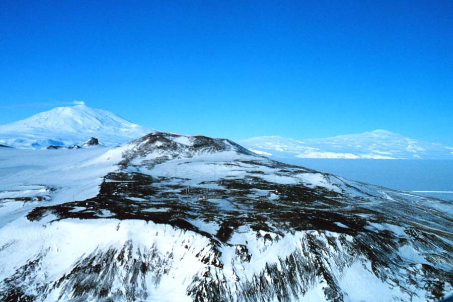
Ross Island combines the active volcano Mount Erebus, two neighbouring Antarctic research stations, historic expedition huts and highly protected penguin habitats. It lies in the Ross Sea near the Antarctic continent. The official Scott Base page and Antarctic Treaty visitor guidelines show that this is a working scientific environment, not a town with open-access sightseeing.
Use ten lessons to understand its volcanic geography, sea ice, early exploration, environmental science and protective rules. Each chapter ends with an activity and answer check. The following worked problem, family learning plan, English–Chinese vocabulary and primary sources help you connect the facts rather than merely memorise names.
Featured photograph: Ross Island panorama with Mount Erebus (left) and Mount Terror (right), John Bortniak, NOAA, November 1978; public-domain U.S. federal image via Wikimedia Commons. Its date does not imply current weather or conditions.

Choose your route: Quick facts · Ten lessons · Worked example · Family lesson · Bilingual vocabulary
Quick facts for readers
| Question | Reliable starting answer |
|---|---|
| Location? | Ross Sea, McMurdo Sound, Antarctic Treaty area. |
| Major mountains? | Mount Erebus, an active volcano (~3,795 m), and Mount Terror. |
| New Zealand station? | Scott Base, first opened 20 January 1957. |
| U.S. station? | McMurdo Station, nearby on Hut Point Peninsula. |
| Historic huts? | Hut Point (Discovery), Cape Evans (Terra Nova) and Cape Royds (Nimrod). |
| Wildlife importance? | Adélie penguins, seabirds and marine mammals, with protected breeding sites. |
| Visitor access? | Station permissions and Antarctic Specially Protected Area permits apply. |
Contents: ten things to learn
1. Locate Ross Island beside the Ross Sea and Ice Shelf
2. Learn why Mount Erebus remains an active volcano
3. Compare Mount Erebus and Mount Terror without merging them
4. Discover what makes Scott Base a working Antarctic station
5. Understand the neighbouring McMurdo research hub
6. Trace three protected historic huts across Ross Island
7. Read the specific Cape Royds penguin protection rules
8. Understand why sea ice, ice tongues and ice shelves differ
9. Connect Ross Island science to the Antarctic Treaty
10. Use Hut Point’s visitor rules to plan a responsible remote lesson
Worked example · Family learning · Vocabulary · FAQs · Sources · Related guides
1. Locate Ross Island beside the Ross Sea and Ice Shelf
Ross Island is an island of volcanic land in the Ross Sea region of Antarctica. It lies near McMurdo Sound and the front of the immense Ross Ice Shelf. The Antarctica New Zealand Scott Base description places Scott Base at Pram Point, on the southern edge of Ross Island, near the boundary between the Ross Ice Shelf and seasonally formed sea ice.
On an Antarctic map, the island can appear connected to the mainland by white ice. A continuous expanse of ice does not make two separate bedrock landmasses one geological island. Distinguish the rock, a glacier or ice shelf, and winter sea ice: they have different origins and can change in different ways.
The NASA Ross Island satellite interpretation identifies Mount Erebus, the Erebus Ice Tongue and nearby research stations on a dated satellite image. Begin with a globe, then a Ross Sea map, then the immediate station area. The maps answer different geographic questions; none should be used alone for operational route or safety decisions.
Try this: Draw two maps, one with Ross Island as a rock island and one with surrounding ice zones. Label the difference.
Does an apparent white ice connection mean Ross Island and the mainland have become a single rock landmass?
No. Ice shelf or sea ice connections do not change the underlying bedrock geography.
← Previous · Contents · Next →
2. Learn why Mount Erebus remains an active volcano
Mount Erebus rises to about 3,795 metres on Ross Island. The Antarctic Treaty Cape Royds visitor information calls it an active volcano, and the NASA Earth Observatory explains the exceptional interest of its long-lived lava lake. This is a source-based geological statement; it is not a reason for casual visitors to approach an active crater.
Erebus is a useful example of a volcano where scientific work connects rock chemistry, heat, gas, volcanic ice caves and atmospheric conditions. A distant landscape photo might show a white summit, but that does not mean there is no volcanic activity beneath snow or that an eruption risk can be predicted by colour.
For a classroom cross-section, show a volcanic cone made of rock, a crater and a shallow lava lake, together with snow and ice at the surface. State that it is a conceptual model. The actual structure, gas composition and change through time require instruments and field science. A beautiful view is not a substitute for geological measurement.
Try this: Draw a cross-section, explicitly mark ‘model only’, and name two measurements needed for scientific interpretation.
Does a snow-covered volcanic slope mean Mount Erebus is extinct?
No. Erebus is an active volcano, despite extensive surrounding ice and snow.
← Previous · Contents · Next →
3. Compare Mount Erebus and Mount Terror without merging them
The historic NOAA panorama taken in November 1978 shows Mount Erebus to the left and Mount Terror to the right on Ross Island. Two large volcanic mountains shape the skyline, but they do not have an identical eruption history or the same role in current monitoring.
The names come from the expeditionary age of Antarctic exploration, recalling the vessels HMS Erebus and HMS Terror. Knowing the names is a start, not a complete biography of the explorers or the rocks. Use reliable accounts to separate ship names, volcano names and the dates of a photograph.
Compare two observations about the image: “There are two distinct peaks visible” describes its content; “both are equally active today” is not established by its appearance. A scientific explanation requires evidence specific to each volcano. That distinction is valuable far beyond Antarctica: a geographical label does not automatically provide a geological measurement.
Try this: Write one caption identifying Erebus and Terror correctly, then name a claim the photo cannot establish.
Can a photograph alone establish whether two volcanoes have the same current activity level?
No. Volcano-specific monitoring and dated geological evidence are needed.
← Previous · Contents · Next →
4. Discover what makes Scott Base a working Antarctic station
The Antarctica New Zealand website places Scott Base on Pram Point, Ross Island. The station history states that it officially opened on 20 January 1957 to support the Commonwealth Trans-Antarctic Expedition and International Geophysical Year. It subsequently developed into a long-lived centre for New Zealand Antarctic science.
Research stations combine many functions: meteorology, laboratories, communications, vehicle operations, field travel planning, supplies and waste handling. An aerial image of a cluster of buildings cannot tell you the number of people presently working there or who has permission to use each facility.
The official base page notes substantial summer activity, but seasonal staffing should not be converted into a precise live count. A useful question is why research data become more valuable when a station can support repeated measurements across years. The response lies in continuity of instruments and observation practices, not simply the number of buildings.
Try this: Make a station systems diagram with science, food, communications, weather, vehicles and environmental management.
Was Scott Base built as a public tourist resort in 1957?
No. It was established to support expeditions and scientific research.
← Previous · Contents · Next →
5. Understand the neighbouring McMurdo research hub
On the same southern part of Ross Island, the United States operates McMurdo Station. The Antarctic Treaty Hut Point guidance mentions both McMurdo and Scott Base and states that their grounds are closed to visitors without prior permission from the respective station management. Two national research programmes can work near each other without being one facility.
This geography illustrates international cooperation and operational differences. A map may place the bases close together but does not identify the arrangements for crossing station property, roads or protected areas. Scientific visitors and support teams operate under institutional and Treaty-authorised procedures, not a public street network.
Consider how a science programme transports instruments or people. It needs logistics coordination, safe movement and environmental permissions. A student comparing McMurdo and Scott Base should label national programme, location and role in a table, avoiding the assumption that all people on Ross Island work for the same organisation or have identical rules.
Try this: Make a two-row table: Scott Base (New Zealand) and McMurdo Station (United States), with their management and purpose.
Can anyone enter either station because the stations are close together?
No. Each station requires advance permission for visitors.
← Previous · Contents · Next →
6. Trace three protected historic huts across Ross Island
Ross Island preserves places connected to the heroic-era expeditions. At Hut Point, Scott’s Discovery-era hut is associated with the 1901–04 expedition. At Cape Evans, the Terra Nova expedition led by Robert Falcon Scott worked in 1910–13. At Cape Royds, Ernest Shackleton’s Nimrod expedition of 1907–09 left a historic hut.
The Hut Point, Cape Evans and Cape Royds Antarctic Treaty visitor pages distinguish these three places and explain their protected status. They are not three names for one hut. Each site has its own historical context, conservation plan and access conditions.
A historical hut is an archive of materials, tools, food packaging and architecture, but it is not a playground. Moving an artefact can remove its interpretive context or damage something irreplaceable. Research photographs, properly dated maps and conservation descriptions are often the most suitable route for families wishing to understand the explorers’ daily life.
Try this: Create a three-row timeline with named cape, expedition and period, using a separate official source for each.
Are Scott’s two expeditions and Shackleton’s Nimrod expedition one event?
No. Their huts, dates, leadership and objectives differ.
← Previous · Contents · Next →
7. Read the specific Cape Royds penguin protection rules
The Antarctic Treaty Cape Royds site guidelines identify an Adélie penguin colony and also refer to Antarctic Specially Protected Area No. 121. Its sensitive breeding habitat is not generally open, and entry to an ASPA requires the relevant permit. Cape Royds also contains the protected Shackleton hut under a separate ASPA designation.
Why protect small pieces of ice-free ground so carefully? Penguins use nesting habitat during a critical period and travel between the sea and colony. A visitor blocking a habitual route, stepping among nests or leaving foreign material can harm wildlife even without taking a specimen.
A penguin count in a photograph is not automatically a scientific population estimate. Some birds are at sea, nesting groups change and survey methods vary. A reliable trend needs a consistent site definition and repeat observations. Protection is based on ecological values, not on a promise that one particular animal will be there for a photograph.
Try this: Draw two differently labelled protected areas at Cape Royds and explain why each exists.
Does a view of the Adélie colony grant permission to walk among the breeding penguins?
No. The colony’s specially protected area is subject to permit requirements.
← Previous · Contents · Next →
8. Understand why sea ice, ice tongues and ice shelves differ
The Ross Sea region offers a natural laboratory for different forms of ice. Sea ice forms when seawater freezes. An ice tongue is an elongated floating extension from a land glacier. The Ross Ice Shelf is a vast floating body of glacial ice that extends outward from grounded glaciers. Those categories have different physical origins, thicknesses and movement.
The NASA image interpretation identifies the Erebus Ice Tongue, which is a useful feature for testing vocabulary. The Scott Base page describes its setting near seasonally formed sea ice and the Ross Ice Shelf. A bright white patch in an aerial photograph cannot on its own tell you which category it is.
A basic exercise compares what happens when a seasonal skin of sea ice forms in winter with the slower movement of glacier-fed floating ice. Accurate study requires satellite observations, thickness measurements and clearly defined dates. No image from 1978 or 2013 should be treated as the current extent without more evidence.
Try this: Draw three side-by-side diagrams and label what water originally formed each ice type.
Does a floating ice shelf form in exactly the same way as frozen sea ice?
No. Ice shelves extend from land glaciers, whereas sea ice forms by freezing seawater.
← Previous · Contents · Next →
9. Connect Ross Island science to the Antarctic Treaty
Ross Island lies within the Antarctic Treaty area. The New Zealand Ministry of Foreign Affairs and Trade explains New Zealand’s historic Ross Dependency claim and the Treaty framework, which encourages peaceful scientific activity while preserving the parties’ different positions on territorial claims.
Article IV matters because it prevents the modern operation of a station from being treated as an automatic basis for new sovereignty claims. The fact that neighbouring programmes cooperate on science does not make the entire area an independent state or erase historical claim positions.
The environmental protocol also requires activities to be planned and assessed. Scientific work, heritage conservation and any authorised visitor activity are all subject to restrictions. On a map, distinguish a national claim, a research station boundary and an Antarctic Specially Protected Area; these are different kinds of information and should not be drawn as if each were a national border.
Try this: Write two careful sentences: one about science cooperation and one about Article IV’s treatment of claims.
Does building a new scientific facility under the Treaty allow a new or enlarged sovereignty claim?
The Treaty provides that activity while it is in force does not create that basis.
← Previous · Contents · Next →
10. Use Hut Point’s visitor rules to plan a responsible remote lesson
The Hut Point visitor-site guidance, revised 2021 states that the Discovery hut is within Antarctic Specially Protected Area No. 158 and requires a permit. Visitors entering the hut must be accompanied by a guide; the guidance also limits the number inside at once and describes roads, station areas and other parts of the peninsula as restricted.
Likewise, Cape Evans and Cape Royds are not interchangeable tourist access points. A site’s visitor guidance is not a personal permit or a guarantee that an authorised operator will land. Conditions, research activity and conservation needs can prevent a visit even when a location appears in a brochure.
Families can make a meaningful route entirely from official photographs: volcano image, Scott Base history, a map of the three huts and a diagram of protected wildlife. The most important evidence habit is to distinguish “can be studied” from “can be physically entered.” Ross Island is an extraordinary classroom without needing to invent a self-guided excursion.
Try this: Write a respectful four-stop virtual study route with a source and a restriction note for each stop.
Is the historic Discovery hut an ordinary open-entry visitor building?
No. It is inside a specially protected area, with permit and guiding conditions.
← Previous · Contents · Next →
Worked example: a small heritage hut and an important caveat
Illustrative classroom calculation, not a travel plan. The Hut Point guidelines discuss a maximum of eight visitors inside the historic Discovery hut at a time. Suppose an authorised educational group hypothetically comprises 24 people and every one is entitled to enter under the same permitted conditions. How many separate groups of eight would that represent?
Divide 24 by 8: 24 ÷ 8 = 3 groups. The arithmetic assumes all 24 were approved and that the official visitor and guide rules could actually be met. It does not grant entry, schedule actual group visits or override wildlife rest periods, current station operations and permitted capacity.
This is an important lesson about applying maths to a real rule. A numerical capacity is a necessary constraint within an authorised activity, not an independent right to enter. A school group cannot create a permit by splitting into smaller groups.
Now ask a second question: if only sixteen people were authorised, would three groups still be allowed because of the 24-person calculation? No. The governing permission and actual eligible participants matter more than an abstract total.
One-hour family or classroom learning plan
Begin with fifteen minutes mapping the Ross Sea, Ross Island, McMurdo Sound and the Ross Ice Shelf. Explain why a white ice connection does not change the island’s bedrock.
Use fifteen minutes to compare Erebus and Terror on the NOAA 1978 panorama. Read NASA’s volcanic interpretation, then write one observation the photograph supports and one unsupported inference about current activity.
Spend fifteen minutes building three history cards for Hut Point, Cape Evans and Cape Royds. Match each with the Discovery, Terra Nova or Nimrod expedition and an Antarctic Treaty protected-area reference.
Finish with the hypothetical eight-person calculation and a visit to the Antarctica New Zealand protected-site overview. Each family member writes one reason science, history and wildlife protection must be coordinated.
English–Simplified Chinese vocabulary
| English | 简体中文 | Meaning here |
|---|---|---|
| Ross Island | 罗斯岛 | Volcanic island in the Ross Sea region. |
| Active volcano | 活火山 | Volcano that remains geologically active. |
| Lava lake | 熔岩湖 | A body of molten rock in a volcanic crater. |
| Sea ice | 海冰 | Frozen seawater. |
| Ice shelf | 冰架 | Large floating extension of glacial ice. |
| Ice tongue | 冰舌 | Narrow floating extension of glacier ice. |
| Adélie penguin | 阿德利企鹅 | Penguin species breeding in the Ross Sea region. |
| Research station | 科研站 | Facility supporting scientific investigations. |
| Scientific monitoring | 科学监测 | Systematic repeated measurement. |
| Historic hut | 历史小屋 | Preserved structure with historic significance. |
| Protected area | 保护区 | Place with restricted activities under a management plan. |
| Visitor guideline | 游客访问指南 | Rules for a named site; not a personal permit. |
| Antarctic Treaty | 南极条约 | International legal framework for Antarctica. |
| Provenance | 来源沿革 | Documented origin, date and source history. |
Frequently asked questions
Where is Ross Island?
In the Ross Sea near McMurdo Sound, within Antarctica.
Is Ross Island the Antarctic mainland?
No. It is an island of volcanic bedrock, though surrounded by ice that may appear continuous.
Is Mount Erebus active?
Yes. NASA and Antarctic Treaty sources describe an active volcano, about 3,795 metres high.
Are Mount Erebus and Mount Terror the same mountain?
No. They are distinct volcanic mountains on Ross Island.
When did Scott Base open?
Antarctica New Zealand gives 20 January 1957.
Which country operates McMurdo?
The United States; nearby Scott Base is operated by New Zealand.
Which hut relates to Shackleton’s Nimrod expedition?
The protected hut at Cape Royds.
Which hut relates to Scott’s Terra Nova expedition?
The protected hut at Cape Evans.
Can you freely walk into the Discovery hut?
No. It is in an Antarctic Specially Protected Area and entry requires a permit and guide.
Why are penguins protected at Cape Royds?
The Adélie breeding colony occupies sensitive habitat covered by special protection rules.
Primary sources and further reading
Historic photographs are used with their observation dates; visitor guidelines are site-specific and do not replace current national and station permissions.
Antarctica New Zealand: Scott Base geography and operations
Antarctica New Zealand: Scott Base history and 1957 opening
NASA Earth Observatory: Mount Erebus and Ross Island satellite study
Antarctica New Zealand: protecting Antarctic historic and special areas
Antarctic Treaty Secretariat: Cape Royds, Shackleton hut and protected penguins
Antarctic Treaty Secretariat: Cape Evans and Scott’s Terra Nova hut
Antarctic Treaty Secretariat: Hut Point, Discovery hut, stations and permits
New Zealand Ministry of Foreign Affairs: Antarctic Treaty and Ross Dependency
NOAA 1978 panorama of Ross Island, public-domain photograph
Keep learning in Antarctica
South Shetland Islands: volcanoes and visitor protection
Antarctica: complete introductory guide
South Orkney Islands: Antarctic research stations