
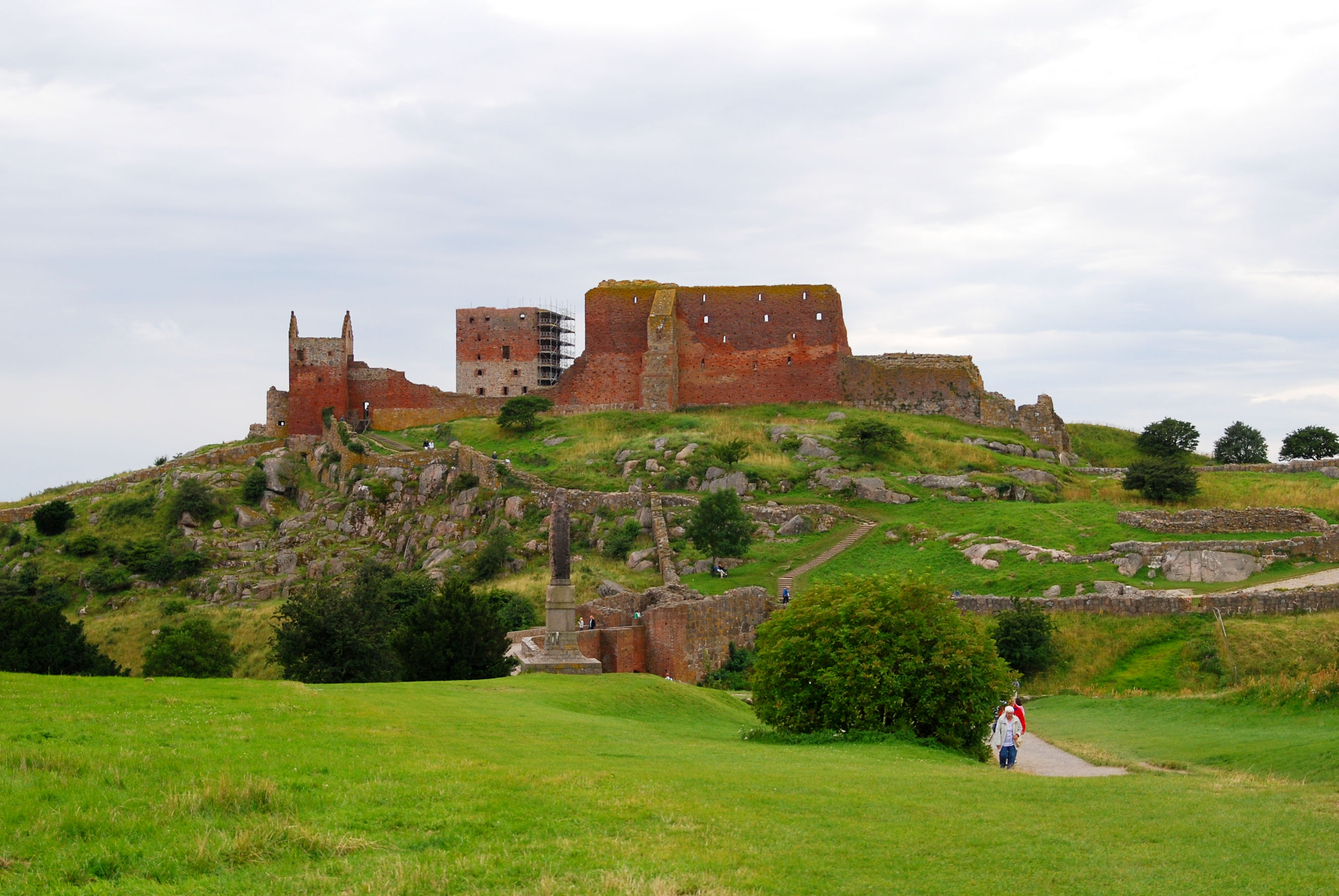
Bornholm is a brilliant place for curious travellers because so much can be learned within a relatively small island. A medieval fortress and a round church raise questions about power and architecture. Hard northern rock and fine southern sand invite a lesson in geology. Fishing villages and craft workshops reveal how everyday skills become local heritage. Rønne and the offshore Ertholmene islands turn maps into practical questions about how a community functions.
This is not another checklist of ten attractions. It is a guide to ten ideas worth understanding while visiting Bornholm, with specific places where you can observe evidence, safe questions to ask and simple learning activities for families, students or adults who enjoy travelling thoughtfully. Each lesson separates what is visible from what needs additional evidence.
Updated October 2026. Public transport, offshore boat trips, museum access and venue opening schedules should be checked for your travel date. Outdoor investigations belong on safe, permitted paths; no learning exercise justifies climbing historic masonry, trampling dunes or approaching unsafe cliff edges.
Ten Bornholm lessons at a glance
| Lesson | Place to explore | Big question |
|---|---|---|
| 1. Why Is a Danish Island Located So Far East in the Baltic? | Rønne harbour, a map of the Baltic, or the ferry approach | How can sea geography help explain an island’s history and economy? |
| 2. What Made Hammershus a Powerful Medieval Fortress? | Hammershus Castle Ruins and its visitor centre | Why can location and visibility matter as much as a high stone wall? |
| 3. Why Were Bornholm’s Medieval Churches Built Round? | Østerlars Round Church and other churches viewed respectfully | What can a building’s shape tell us about its community and historical needs? |
| 4. How Did Ice and Stone Shape Hammerknuden? | Hammerknuden, Hammerhavn, Opalsøen and designated trails | Can you tell natural landforms apart from those changed by quarrying? |
| 5. How Does the Baltic Shape the Sanctuary Cliffs? | Helligdomsklipperne between Tejn and Gudhjem | What changes when waves repeatedly strike cracks in solid rock? |
| 6. Why Can You Hear an Echo in Ekkodalen? | Ekkodalen fracture valley in Almindingen | How do sound, distance and reflective surfaces interact? |
| 7. Why Is Dueodde Sandy While North Bornholm Is Rocky? | Dueodde beach, dunes and planted coastal areas | How do sediments move, accumulate and become stabilised? |
| 8. Why Did Smoked Herring Become So Important to Gudhjem? | Gudhjem harbour and traditional smokehouses | How do food preservation, trade and local identity become connected? |
| 9. What Do Svaneke’s Crafts Tell Us About Materials and Design? | Svaneke workshops, harbour and old streets | What turns raw materials and skilled processes into objects that people value? |
| 10. How Do Rønne and Christiansø Show What Island Life Requires? | Rønne’s public harbour areas; Christiansø and Frederiksø if sailing | What services and decisions support communities separated by water? |
For a conventional attraction itinerary: See Top 10 Places to Visit When Touring Bornholm. This companion instead explains the history, geography, science and culture behind what you will see.


How to use these lessons on a real holiday
Choose one or two ideas per day rather than trying to conduct ten formal activities. A younger child may enjoy drawing the shapes of the cliffs and round church. A teenager might compare evidence about landforms or trade, while an adult may be drawn to military history, sustainable tourism or craft economics. The most successful learning travel feels like an interesting conversation prompted by a place, not a worksheet that must be completed before lunch.
For each location, make three notes: what I saw, what I think it means, and what source could confirm it. That final distinction is valuable. A persuasive visual impression is not always accurate, and a place-name or legend is not automatically a scientific explanation.
1. Why Is a Danish Island Located So Far East in the Baltic?
Best place: Rønne harbour, a map of the Baltic, or the ferry approach. Central question: How can sea geography help explain an island’s history and economy?
The bigger idea
Begin with the simplest geographical observation: Bornholm is Danish, but its position east of the main Danish islands makes its setting different from many visitors’ mental picture of Denmark. Rather than imagining a country as one continuous shape, look at sea crossings, routes between Scandinavian shores and the long role of islands in navigation. An island is part of a political state, yet it also has its own practical network of transport, supplies, communications and local economic life.
Look for the evidence
Use a map to identify Denmark, Sweden, Germany, Poland and Bornholm. Then follow the sea routes that connect places rather than judging distance only by a line drawn across a map. At Rønne, watch the scale of vehicles and cargo that arrive or leave on ferries where observation is allowed. Consider how a port, a supermarket and a local bus are linked through logistics even when they appear to have unrelated jobs. A family can find a surprising amount of geography in a simple harbour walk.
A practical learning activity
Draw a four-column chart headed people, food, materials and information. For each, write how it might reach the island, who receives it and what could interrupt the connection. Compare how this would change if the island were connected by a road bridge. For an extra challenge, ask which local products might travel outward and why shipping schedules influence both residents and visitors.
What not to assume
Do not describe Bornholm as politically independent or assume that a ferry is available on any date just because it appears on a map. The precise pattern of public services and shipping changes with time. A nearby coast is not necessarily a practical quick trip when sea conditions and ports are considered.
Visitor planning and respect
This lesson is easiest at the beginning of a holiday, particularly around Rønne and the official tourist information centre. You do not need to enter restricted port spaces to observe infrastructure; public viewpoints, route maps and ferry-operator information are enough.
Try this follow-up question: What is easier to supply on a large mainland rail network than on an island? What services might an island provide locally to reduce dependence on deliveries?
Back to all ten lessons · Next lesson
2. What Made Hammershus a Powerful Medieval Fortress?
Best place: Hammershus Castle Ruins and its visitor centre. Central question: Why can location and visibility matter as much as a high stone wall?
The bigger idea
Hammershus allows visitors to think like the people who planned and used medieval fortifications. Its walls survive because of a long and complicated political history, but the landscape is the first clue to how the fortress worked. The building occupies a high rocky position above the Baltic. A defensive site needed to control approaches, watch movement, protect resources and send signals. The walls matter, but so do routes, height, sea views, fresh water and the effort required to transport supplies up to the site.
Look for the evidence
Walk the permitted approach from the visitor centre, pausing to look at the gradients and remaining gates. Where would a group approaching on foot be visible? Which parts of the rock are naturally difficult to cross? Where could people gather safely inside? In the exhibition, try to distinguish historical evidence from a modern reconstruction. A photograph of ruins is not a reliable floor plan until it is matched with interpretation and archaeological research.
A practical learning activity
Ask a child to design two tiny model fortresses on paper: one with thick walls on flat open land and another with more modest walls on a steep defended headland. Compare how an approaching person reaches the gate, how defenders see danger and how food and water are delivered. The model may reveal why defence always involves trade-offs rather than a single ‘strongest’ feature.
What not to assume
Avoid claiming that a specific ruined wall was a bedroom, prison cell or guardroom unless the site’s interpretation identifies it. Building phases, medieval politics and later abandonment are complex. Hammershus is a protected ruin, so walking on masonry to demonstrate ‘defence’ would damage the very evidence the lesson needs.
Visitor planning and respect
Allow time for the visitor centre and outdoor grounds, and remember that the visitor centre’s accessibility does not mean every historic surface outside is step-free. Exposure to wind and steep paths makes sensible shoes and supervision essential.
Try this follow-up question: Why might a fortress lose military importance even if the remaining walls are still formidable? Think about changing weapons, ports, political control and communication.
Back to all ten lessons · Next lesson
3. Why Were Bornholm’s Medieval Churches Built Round?
Best place: Østerlars Round Church and other churches viewed respectfully. Central question: What can a building’s shape tell us about its community and historical needs?
The bigger idea
Østerlars is among Bornholm’s most distinctive medieval churches. Its round shape makes it a natural place to explore the difference between a building’s religious purpose, defensive possibilities and the technology of masonry. Instead of repeating the easy claim that ‘it was round so soldiers could fight’, notice that architecture can meet several purposes and change across centuries. The building was, and remains, a place connected with worship and community life, with features that visitors can interpret through signs and appropriate historical sources.
Look for the evidence
Look for the circular plan, thick exterior wall, openings, entrances and the way an enclosed space is organised. Imagine how people would have experienced the building when it was new: what light entered, which spaces were shared and how the building stood within the surrounding countryside. Compare its shape with a rectangular church or with Hammershus. This contrast shows why a fortress and a religious building should not automatically be analysed as the same type of architecture.
A practical learning activity
Use a compass or household object to draw a circle, then sketch a rectangle with similar floor area. Where can you place doors, windows, supports and an area for people to gather? If the walls need to carry a heavy roof, which questions must a builder solve? The result is not a reconstruction of Østerlars; it is a simple engineering exercise inspired by the building.
What not to assume
Historic construction dates and military functions are subject to interpretation. Avoid stating that all four round churches are identical or that every level is open to visitors. During services, the correct action is to respect worship rather than treat the building as a continuously open exhibit.
Visitor planning and respect
Check church-specific visiting hours, possible admissions and services. A short exterior study may be more suitable for a family than an intrusive interior visit. Accessibility of any stair or upper level cannot be assumed.
Try this follow-up question: How would your explanation of the church change if you learned it had been altered over several centuries? Why is a surviving old building evidence of more than one historical moment?
Back to all ten lessons · Next lesson
4. How Did Ice and Stone Shape Hammerknuden?
Best place: Hammerknuden, Hammerhavn, Opalsøen and designated trails. Central question: Can you tell natural landforms apart from those changed by quarrying?
The bigger idea
The exposed rocks around Hammerknuden help explain why Bornholm’s northern and southern landscapes look so different. Glaciers once moved through this region and helped expose, abrade and reshape hard bedrock. Later people worked parts of the rock for building material and created a landscape where natural features sit beside quarry-derived hollows, lakes and infrastructure. This is a useful reminder that a beautiful place is often a record of both natural processes and human labour.
Look for the evidence
Choose safe, marked viewpoints where rock surfaces, lakes and former quarry areas can be appreciated without scrambling. Look for broad rounded shapes, steep cut faces and places where a harbour or path appears deliberately built. Ask how water collects differently in a natural hollow and a worked excavation. Opalsøen and Hammersø should not be casually treated as the same geological feature simply because both are visible lakes in the north.
A practical learning activity
Create a two-column observation notebook. In the first column, draw features that seem likely to be shaped by ice, water or weather. In the second, place features that probably reflect quarrying, roads or harbour works. Mark each judgment ‘certain’, ‘likely’ or ‘unsure’. Then use destination interpretation to improve the answer. That final step demonstrates the difference between a plausible guess and a supported explanation.
What not to assume
A cliff face alone cannot tell you the complete sequence of events or precise age of the rock. Don’t assume a lake is a supervised swimming site or that old working landscapes are safe places to explore without restrictions.
Visitor planning and respect
Walk the headland only in suitable weather and on permitted paths. Sturdy footwear is important on damp rock. Pair the area with Hammershus for one geography-and-history day rather than crossing the island repeatedly.
Try this follow-up question: Why does a building stone connect geology to architecture? Think about how local rock might influence the appearance of roads, walls and harbours.
Back to all ten lessons · Next lesson
5. How Does the Baltic Shape the Sanctuary Cliffs?
Best place: Helligdomsklipperne between Tejn and Gudhjem. Central question: What changes when waves repeatedly strike cracks in solid rock?
The bigger idea
At Helligdomsklipperne, cracks, coves and caves allow you to see the patient work of a coastline. Even resistant granite can be altered over long periods as waves act on joints and weaker points. The striking pillars and openings are not carved in a single event. They are the visible results of rock structure, water action and deep time. Local legends and names add a cultural layer that is worth learning without confusing folklore with a scientific claim.
Look for the evidence
From a safe upper viewpoint, identify vertical fractures, broad rock faces and narrow gaps. Think of the coast as a shape that is continuing to change, not an object completed long ago. Compare the rock you can see with the rounder or more broken formations elsewhere on Bornholm. If you visit Bornholm Art Museum nearby, look at how a landscape becomes a subject of composition, mood and artistic choice.
A practical learning activity
Draw three frames of the same fictional cliff with a pre-existing crack: now, after many waves, and after a much longer time. Explain what evidence would be needed to support the sequence. You can also compare a scientific caption describing a rock formation with a creative caption inspired by its shape. Keep the two types of statement separate.
What not to assume
You cannot date a cliff or explain every cave accurately by looking at one photograph. Nor can the existence of a named sea cave make it suitable for everyone to enter. Conditions, wave exposure and narrow steep paths can make the lower reaches inappropriate.
Visitor planning and respect
Official marked routes offer rewarding views without entering every cave. Summer boat services from Gudhjem may offer an additional perspective when they operate, but they remain weather- and timetable-dependent. Check museum hours independently.
Try this follow-up question: Why are an artist’s image and a geologist’s explanation both useful, even though they make very different kinds of claims about the same place?
Back to all ten lessons · Next lesson
6. Why Can You Hear an Echo in Ekkodalen?
Best place: Ekkodalen fracture valley in Almindingen. Central question: How do sound, distance and reflective surfaces interact?
The bigger idea
Ekkodalen, the Echo Valley, is more than a place where people call out and wait for a reply. Its steep rock faces give visitors a way to think about sound waves and reflected energy. An echo can be heard when reflected sound arrives distinctly enough after the original sound. A closely spaced series of reflections may instead produce reverberation. The valley shape and a listener’s position influence the result, and weather or background noise changes what is easy to hear.
Look for the evidence
Find a permitted open spot that does not disturb other visitors or wildlife. Notice which rock faces are opposite and whether there are trees, bends or other surfaces between you and the far side. The forest surrounding the valley introduces another study: sound can seem quite different in a leafy woodland from an open harbour or room, although the precise behaviour depends on many factors.
A practical learning activity
Use a gentle single clap if local conditions allow and see whether you can distinguish a repeat from the original sound. Try a second safe position, then write down what changed. Do not stage a shouting contest. In the classroom, children can compare an empty hard-walled room with a room containing curtains and soft furnishings to discuss sound reflection and absorption without disturbing a nature reserve.
What not to assume
It is inaccurate to promise that every shout produces the same number of echoes from every point or that a particular distance can be calculated without measurement. The valley is a protected natural setting, not an outdoor laboratory where any experiment is automatically permitted.
Visitor planning and respect
Use signed forest paths, take care after rain and avoid walking under vulnerable trees during strong wind. The valley is well suited to a central-island day paired with another gentle cultural stop.
Try this follow-up question: What is the difference between an echo, reverberation and ordinary background noise? Why do architects and sound engineers care about those differences indoors?
Back to all ten lessons · Next lesson
7. Why Is Dueodde Sandy While North Bornholm Is Rocky?
Best place: Dueodde beach, dunes and planted coastal areas. Central question: How do sediments move, accumulate and become stabilised?
The bigger idea
Dueodde’s pale fine sand surprises people who have just explored Hammerknuden. One island can contain dramatically different coastlines because its geology, exposure, sediment supply and movement of water differ from place to place. At Dueodde, sand, dunes, vegetation and sea create an evolving coastal system. The beach is enjoyable in its own right, but it also gives an unusually clear opportunity to discuss sediment, erosion and conservation.
Look for the evidence
Look from a designated boardwalk or beach access at where loose sand changes to dune vegetation and then to planted or naturally vegetated coastal zones. The vegetation is not decorative; roots and plants help hold soil and sand in place. The beach’s contours and patterns may change between visits due to wind and wave conditions. Notice the contrast between wet compact sand near the water and dry loose sand farther back.
A practical learning activity
Without digging in protected dunes, draw a simple side-view diagram from the sea through wet beach, dry beach, dune and vegetation. Add arrows showing how wind might move dry grains inland and waves might redistribute sand. Discuss why trampling vegetation can make erosion more likely. A separate home experiment using a shallow tray of sand and a gentle fan can illustrate wind movement without damaging the real habitat.
What not to assume
Do not generalise that all sandy beaches are equally safe for swimming or that every sand grain comes from one nearby rock. Coastal sediment history is complicated. Never treat a quiet-looking sea or an attractive photo as an assurance of safe current conditions.
Visitor planning and respect
A beach day should be planned around weather and water safety. Follow local bathing advice and keep to paths across dune vegetation. The lighthouse and nearby Cold War museum offer possible add-ons when open, but are separate attractions with their own admission and access rules.
Try this follow-up question: If a dune’s plants are damaged, what might change over years? How would you test whether a beach grows, retreats or simply moves sand seasonally?
Back to all ten lessons · Next lesson
8. Why Did Smoked Herring Become So Important to Gudhjem?
Best place: Gudhjem harbour and traditional smokehouses. Central question: How do food preservation, trade and local identity become connected?
The bigger idea
Gudhjem’s smoked fish culture is a lively lesson in the relationship between food science and an island economy. Before reliable modern refrigeration, smoking, salting and drying helped preserve fish and made it easier to store or trade. The local speciality often called Sol over Gudhjem is a modern visitor-friendly doorway into that longer story. A traditional dish can become a symbol of a place because it links ingredients, practical knowledge, trade and community memory.
Look for the evidence
From the public harbour, look for evidence of a working fishing history: quay space, boats, stores and smokehouse buildings. Inside a smokehouse that welcomes visitors, ask what preparation methods are used, and notice that producing a safe, appealing product requires control over ingredients, heat, timing and handling. The specific equipment and recipes can vary, so avoid treating one demonstration as the universal Bornholm process.
A practical learning activity
Choose one food preservation method, such as smoking, drying, refrigeration or salting. For each, ask what problem it addresses, what equipment it needs and what risks remain. Younger children can compare a perishable fresh food with a preserved product through an adult-guided discussion rather than preparing or eating unsafe food. Older students can explore how a local product becomes a tourist experience through packaging, stories and restaurants.
What not to assume
Food preservation is not the same as making food indefinitely safe at room temperature. Do not use an old smoked-fish practice as advice for home storage without current food-safety guidance. People with fish, egg or other food allergies need ingredient information from the actual food provider.
Visitor planning and respect
Smokehouse menus and opening dates vary across seasons. Plan a relaxed meal, respect the harbour’s working areas and pair Gudhjem with the Sanctuary Cliffs rather than squeezing it into a remote sightseeing loop.
Try this follow-up question: Why might a town become famous for a food that began as a practical preservation technique? What changes when the product becomes a souvenir or restaurant experience?
Back to all ten lessons · Next lesson
9. What Do Svaneke’s Crafts Tell Us About Materials and Design?
Best place: Svaneke workshops, harbour and old streets. Central question: What turns raw materials and skilled processes into objects that people value?
The bigger idea
Svaneke’s crafts help connect an abstract idea—value—to things visitors can see being made. Glass, ceramics, confectionery and other small-scale production depend on material properties, tools, skilled hands and design choices. A finished object may be beautiful, but its story also includes heat, breakage risk, repeated practice, workshop organisation and the need to sell work sustainably.
Look for the evidence
When a demonstration is available, ask what the maker starts with and what changes during the process. In glasswork, heat and controlled cooling matter. In ceramics, shaping and firing shape the final result. In confectionery, ingredient ratios, heating and timing influence texture. Do not claim to know a particular workshop’s proprietary method from outside observation. In the surrounding streets, notice how small storefronts, traditional buildings and visitors interact in a town that is also home to residents.
A practical learning activity
Choose one object and draw a five-stage process map: material, preparation, transformation, finishing and sale or use. Then write a second list of hidden skills, such as measurement, judgment, timing and quality checking. Finally ask whether a high price necessarily proves better quality or whether design, scarcity and story can also influence perception.
What not to assume
A workshop can be hot, crowded or private. Ask before photographing people, follow safety rules and do not make assumptions about whether a craft can be learned through a short public demonstration. Distinguish an artisan’s individual practice from the economic life of every resident in Svaneke.
Visitor planning and respect
Check individual workshops and demonstration times rather than expecting every door to be open. Allow time for conversation without blocking entrances or work areas, and combine the visit with a harbour walk or a nearby cultural site.
Try this follow-up question: If a handmade object and a factory-made object serve the same function, what differences might matter to a buyer? Which claims would need evidence instead of advertising?
Back to all ten lessons · Next lesson
10. How Do Rønne and Christiansø Show What Island Life Requires?
Best place: Rønne’s public harbour areas; Christiansø and Frederiksø if sailing. Central question: What services and decisions support communities separated by water?
The bigger idea
The contrast between Rønne and tiny Christiansø makes a powerful final lesson. A larger island town can host transport, cultural facilities, shops and public services across a broad area. A much smaller offshore community faces different constraints in moving supplies, waste, medical assistance and people. Neither setting can be understood simply by counting scenic buildings. Geography creates practical questions that must be solved through institutions, transport and relationships with larger places.
Look for the evidence
At Rønne, notice the roads and buildings needed for harbour movement and town services. During a correctly planned Christiansø trip, observe the more compact waterfront, historic fortifications and limited physical space. Do not treat residents’ everyday routines as part of a visitor performance. Both places have cultural histories, but the lesson here is how they function today as well as how they looked in the past.
A practical learning activity
Imagine planning one week for a small island settlement of a hundred hypothetical residents. Create categories for water, food, electricity, waste, schools, medical care, communication and emergency transport. Identify which can be provided locally, which require cooperation with larger centres and what happens if severe weather stops the boat. This is an exercise in systems thinking rather than a claim about Christiansø’s actual service arrangements.
What not to assume
Do not invent details about a community’s current water, power, governance or healthcare systems unless supported by current local sources. Historic forts do not imply that the present settlement has no modern services. A boat journey might be cancelled even on a sunny-looking day because wind and sea conditions elsewhere matter.
Visitor planning and respect
Treat a Christiansø excursion as a separate, weather-dependent day with confirmed transport, return options and accessibility information. If a sailing does not operate, continue the lesson in Rønne using maps, public exhibits and responsible observation of transport networks.
Try this follow-up question: How does a community decide which services to keep local and which to share? What happens when tourism adds more people but infrastructure remains limited?
Back to all ten lessons · Build a learning itinerary
A three-day Bornholm learning itinerary
Learning themes are easier to remember when they are grouped by geography. Bornholm naturally divides into the rocky north, towns and eastern coast, forested interior and sandy south. A separate offshore visit is rewarding when weather and schedules cooperate, but should never become a rigid promise.
Day 1 — Geography, medieval politics and bedrock
Begin in Rønne with a simple map orientation, then continue to Hammershus for a discussion of fortress planning. Stay in the same northern region for Hammerknuden and examine the contrasts between natural rock and altered quarry landscapes. If energy runs low, cut the second outdoor walk short. One well-understood site can be more valuable than several rushed photographs.
Day 2 — Coastal forms, craft and food
Combine the Sanctuary Cliffs with time in Gudhjem and one craft encounter in Svaneke. Ask how geology gives each coastal section its shape, how a food-preservation practice becomes heritage and why skilled craftsmanship matters in a local economy. A boat between Gudhjem and the cliffs is optional where services operate; the learning does not depend on it.
Day 3 — Sound, sand and community systems
Visit Ekkodalen and Almindingen in the morning, then move south to Dueodde for the beach-and-dune lesson. Return to Rønne for a final discussion about island transport and services. If you have another free day, add Christiansø through an officially booked boat crossing, subject to sea conditions, rather than attempting to squeeze it between inland attractions.
Learning without a car or with limited mobility
Not every learning location has equal access. The Hammershus visitor centre is easier to use than some historic outdoor paths. Østerlars may involve historic building limitations. Helligdomsklipperne includes steep and potentially slippery access in some parts, while Dueodde’s dunes and beaches can be challenging for wheels even if a designated approach improves accessibility. For families using a stroller or wheelchair, decide which educational question can be explored from an accessible viewpoint, museum or map instead of requiring a descent or climb.
Buses support travel on Bornholm, but their routes and frequency must be checked for the actual day. A school or family group may find it worthwhile to design a slower itinerary around Rønne and one additional area rather than treating a compact island as if every stop were reachable on demand. Boat trips are particularly sensitive to schedules and weather.
Teaching critical thinking with real-world travel
The most useful habit in these ten lessons is not learning a list of facts. It is noticing the difference between observation, inference and evidence. A student can see a cliff, infer that water shaped it and then use maps, geology explanations or physical examples to support or revise the inference. At a fortress, they can notice a steep site and ask whether defensive advantage follows. At a harbour, they can notice containers or ferries and ask which economic flows depend on them.
- Observation: describe what is physically present without adding an explanation.
- Hypothesis: give a possible reason and identify what would challenge it.
- Evidence: seek reliable interpretation, maps, signs, scientific resources or direct measurements.
- Revision: change the explanation when new evidence makes the old version weaker.
- Respect: keep the site, residents and wildlife safe while asking the question.
The same approach can strengthen classroom learning. Instead of memorising ‘do this step’, a learner gets used to asking why it is justified. EduKate’s Secondary 1 Mathematics guide discusses this kind of deliberate transition from doing calculations to understanding structures and explanations.
Bornholm educational travel FAQs
Is this guide appropriate for primary-school children?
Yes, if the activities are simplified. Focus on noticing shapes, drawing two contrasting places, making short lists and asking one question at a time. Adults must supervise all coastal and harbour visits.
Can teenagers use it for geography or history projects?
Yes, as a source of topics and observations. Formal school assignments should additionally consult reliable geological, historical and primary sources and cite them correctly.
Do I need to know Danish?
No. English visitor information is available for a number of major attractions, although some local interpretation may be in Danish. Bring a translation method and avoid guessing from a sign.
Is the geology lesson a formal field experiment?
No. It is an observation-based introduction. Measuring rock age, coastal erosion rate or sound reflections accurately requires proper methods, permissions and specialist tools.
Can we visit both Hammershus and Hammerknuden on one day?
They are geographically near each other and can make a sensible northern day, provided the party has the energy and weather is safe.
What is the difference between Helligdomsklipperne and Dueodde?
The first is a dramatic rocky cliff area, and the second is famous for sand, dunes and a broad beach. They illustrate different coastal processes and visitor safety issues.
Are all historic churches museums?
No. Churches may remain active religious spaces and have services or restrictions. Check visitor times and respect worship.
Can we see craft demonstrations on any day?
Not necessarily. Each workshop controls its opening times and demonstrations, and activities vary seasonally.
Does smoking fish make it safe indefinitely?
No. Food preservation requires correct handling and storage. Follow current provider information and food-safety guidance rather than assuming a traditional process removes all risk.
How do we visit Christiansø?
Plan a separate boat excursion only after checking the operator’s sailing, return trip, sea conditions and accessibility arrangements.
What if the weather is poor?
Use museums, visitor-centre exhibitions, workshops that are open, indoor learning and maps. Do not continue unsafe cliff or sea activities just to finish an itinerary.
How do I know whether a statement is a fact or a theory?
Ask for the source, identify what the statement directly describes and separate the observation from its explanation. This is especially important for geological dates, medieval functions and present-day island services.
Related eduKate travel and learning guides
Bornholm | Top 10 Places to Visit · Denmark | Top 10 Places to Visit · World Travel Hub · Secondary 1 Mathematics Tutor Clementi | Small Groups Tutorials.
Official references and photograph attribution
Sources and visitor information reviewed 20 October 2026. Transport, seasonal museum access, boat schedules and safe routes should always be checked shortly before travel. The learning questions are educational prompts, not substitutes for formal scientific analysis or local safety instructions.
Visit Denmark — Hammershus Castle Ruins
Visit Denmark — Hammershus Visitor Centre
Visit Denmark — Østerlars Round Church
Visit Denmark — Hammerknuden Landscape
Visit Denmark — Helligdomsklipperne Sanctuary Cliffs
Visit Denmark — Dueodde and Strandmarken
Visit Denmark — Bornholm Visitor Information in Rønne
Visit Denmark — Bornholm Attractions Overview
Wikimedia Commons — Hammershus Photograph and License
Bornholm offers a satisfying answer to an important question about educational travel: can a holiday change how we understand the ordinary world? A fortification becomes a question about government; a fish smokehouse becomes food science; a dune becomes environmental management; and a small ferry port becomes a lesson in how communities depend on one another. Curiosity turns a beautiful place into something you remember and can explain.