
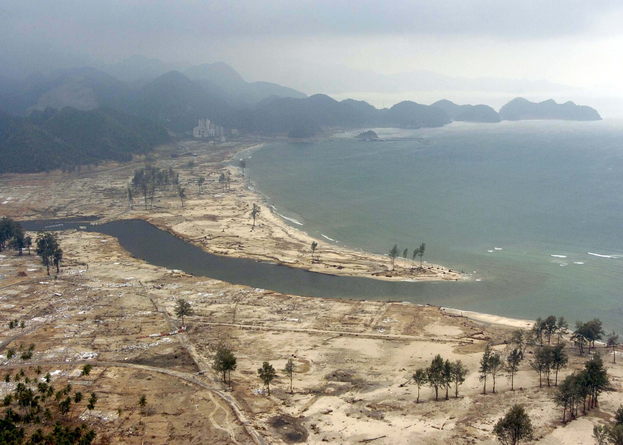
Did you know? On 26 December 2004, an immense undersea earthquake off northern Sumatra set the Indian Ocean in motion. Tsunami waves struck coastlines in Indonesia, Sri Lanka, India, Thailand and other countries. They did not stop at political borders. People thousands of kilometres from the rupture were affected by a disaster that began beneath the sea.
The UNESCO–NOAA historical tsunami data record about 228,000 people dead or missing, presumed dead, across 15 countries, using an updated compilation. Counts vary slightly among historical datasets and reporting dates. Those are people, not merely an abstract numerical lesson.
The tsunami did not destroy the civilisation of an entire ocean basin. It devastated communities, homes, livelihoods and vital services, while national and international institutions continued. The lasting lesson is that an interconnected world needs hazard detection, warnings people can actually receive, locally understood evacuation choices and the capacity to rebuild with dignity.
The 2004 Indian Ocean tsunami: answers in one minute
| Question | Evidence-based answer |
|---|---|
| When? | 26 December 2004. |
| What caused it? | A magnitude 9.1 megathrust earthquake near northern Sumatra, Indonesia. |
| Was it one ordinary wind wave? | No. It was a series of long tsunami waves generated by rapid displacement of the seafloor. |
| Where did damage occur? | Around the Indian Ocean, with especially severe impacts in Indonesia, Sri Lanka, India and Thailand. |
| How many died or went missing? | Approximately 228,000 across 15 countries in an updated NOAA/UNESCO compilation. |
| Why was the toll so high? | Extremely severe near-field hazards combined with exposed communities, limited knowledge and the lack of a coordinated Indian Ocean warning system at the time. |
| What changed later? | Countries established and strengthened regional tsunami warning and mitigation systems, monitoring, education and drills. |
| What is the future lesson? | Warnings must connect real science to local decisions, accessible routes and repeated community practice. |
Before the disaster: an ocean connects more than beaches
The Indian Ocean connects fishing villages, port cities, tourism businesses, island communities and international shipping routes. Families make livelihoods from coastal trade, agriculture, fishing and travel. For some, the shoreline is also home, heritage and a place of deep personal meaning.
The same connected ocean also carries physical hazards. An earthquake beneath one part of the basin can displace enough water to affect other coasts. That does not mean every shore will receive the same wave height or experience the same timing. Underwater depth, coastal shape and distance all influence what happens.
This is the starting point for civilisational thinking. Geographic connections create opportunities but also shared risks. A hazard generated in one country’s waters may demand action by governments and communities that were not involved in the original geological event.
The earthquake: a rupture beneath northern Sumatra
On 26 December 2004 a massive magnitude 9.1 earthquake occurred along a subduction zone off Sumatra. One tectonic plate was moving beneath another, and a large fault ruptured. Part of the seafloor moved vertically, displacing an enormous volume of water above.
The US National Oceanic and Atmospheric Administration records the earthquake and the tsunami it generated. Its historical analysis explains why the physical rupture was so consequential: the moving seafloor disturbed the ocean on a scale that could transmit energy across an entire basin.
Tsunami means a long water wave generated by displacement, not simply a large surf wave created by local wind. In deep water, its height may be comparatively modest while its wavelength and energy are enormous. As the waves enter shallower coastal waters, they can grow in height and surge inland.
Did you know? The first wave is not always the biggest
People often imagine a tsunami as one unmistakable wall of water. In reality, tsunamis can involve multiple surges, with strong currents, flooding and withdrawals of water occurring over time. The first wave is not guaranteed to be the largest.
That matters because a person may wrongly believe it is safe when water first recedes or when one wave has passed. The NOAA tsunami education resource explains that the danger can continue for hours, and official instructions remain important even after the most visible water has withdrawn.
For students, the useful scientific picture is a sequence of energy moving through water and interacting with local geography. It is not a cartoon in which every beach receives the same single wave at the same time.
Why Aceh faced an especially severe emergency
Northern Sumatra lay near the earthquake source, so parts of Aceh had very little time between strong shaking and tsunami arrival. The UNESCO-IOC twentieth-anniversary account describes how waves struck some coastlines within minutes.
In such near-field events, a distant technical bulletin may arrive too late to be the first useful sign. Strong or prolonged coastal shaking can be a natural warning. People need prior knowledge of safe routes and local evacuation plans, because the available time may be extremely short.
The historical tragedy cannot be reduced to a claim that individuals made poor choices. Information, infrastructure, the speed of the hazard, physical vulnerability and access to safe ground varied. Many people faced conditions with little chance to obtain outside assistance before the waves arrived.
How the waves reached other countries
Tsunami energy moved across the Indian Ocean, striking Sri Lanka, India, Thailand, the Maldives and coasts much farther away. Islands, bays and beaches received different effects depending on underwater geography, shoreline features and exposure.
Some populations farther from the source had more time before waves reached them, but the Indian Ocean did not have a comprehensive operational regional warning and mitigation system like the one that existed in the Pacific. The UNESCO-IOC programme history explains how the 2004 catastrophe prompted wider international coordination.
Time on a clock is not the same thing as useful warning time. Scientific detection must become a clear advisory, then a national decision, then a message understood by local residents, and finally an achievable protective action. Each handoff is a potential weakness.
Why a precise death toll is difficult
The scale of loss was extraordinary, and the numbers have been revised over time. NOAA’s updated 2024 historical poster reports 227,899 dead or missing and presumed dead across 15 countries. Its historical-events page may display 227,898 because published summaries and datasets have not always used identical versions.
The tsunami followed the earthquake so quickly that it is difficult to separate every death caused by shaking from every death caused by inundation. Remote settlements, missing residents and disrupted records added further uncertainty.
A good educational article states the source and date of a count. It does not turn a difference of one person between databases into a dramatic dispute, nor imply that a statistical tally captures every family’s experience.
People were affected in profoundly different ways
For some coastal communities, waves swept away homes and fishing equipment. Elsewhere, roads, bridges, ports, schools, hospitals and local water supplies were damaged. People needed urgent rescue as well as food, sanitation, medical treatment and places to stay.
Damage could continue to affect livelihoods after the coastline became accessible. Fishing families required boats and markets, not only temporary shelter. Children needed schools and support. Farmers needed to understand whether inundated land and water sources were safe to use again.
This is why response must extend beyond the first days of international headlines. The disaster’s physical shock occurred on 26 December, but reconstruction and social recovery operated on many different time scales.
Did a lack of warning technology cause every death?
No. The lack of a regional Indian Ocean tsunami-warning system was a major weakness, but the death toll also reflected the near-source arrival time, population exposure, infrastructure, knowledge and unequal evacuation options.
The UNESCO programme describes how the Pacific had established warning capabilities before 2004, while the Indian Ocean lacked equivalent coordinated real-time infrastructure. The event accelerated global investment in warning and mitigation.
A warning system improves the opportunity to act. It cannot move people to safety by itself. The full protective chain includes education, decisions about development, accessible routes, clear responsibility and practice.
From an earthquake signal to a decision at the beach
Imagine an earthquake detected by seismometers. Analysts estimate location, depth and magnitude. Sea-level instruments help assess the tsunami, and forecasting systems model possible impacts. Regional centres communicate information to national warning centres.
The national message still needs translation into local action: which coast is at risk, what protective measure is appropriate and how residents will receive that instruction. People may speak different languages, live without constant electricity, travel as tourists or need help moving.
A modern warning process should be tested end to end. Measuring the speed of data transmission alone is not sufficient if schools, hotels, remote villages or people with disabilities cannot act on the warning.
Natural signs can matter when official messages cannot arrive in time
The NOAA tsunami guidance identifies important natural signs: strong or prolonged ground shaking near the coast, an unusual rapid rise or retreat of the sea, or a loud ocean roar. People in an identified tsunami hazard area should follow local emergency guidance promptly.
These signs do not all appear in every tsunami, so waiting to observe every sign is dangerous. There may also be earthquakes that are not felt in places later threatened by waves. That is why official warnings and local preparedness must complement natural hazard awareness.
The specific evacuation route, safe building and assembly area depend on the location. Historical articles are not substitutes for official local hazard maps or emergency procedures.
The human cost of poor information transfer
Consider a teacher who understands tsunamis, a local official who receives a warning, a phone network that fails, and a family who does not know where high ground is. Knowledge exists at different places in the system, but it has not reached the person making an immediate decision.
This is a failure of transfer and coordination. It resembles problems in other parts of civilisation: an engineering design unknown to maintenance teams, a hospital instruction unread by patients or a food-safety report that fails to reach market sellers.
The solution is not simply to generate more information. It is to ensure the right information reaches the right people in a form they can act on, while they still have the opportunity.
How the warning system changed after 2004
In 2005, UNESCO’s Intergovernmental Oceanographic Commission established an Indian Ocean tsunami warning and mitigation coordination group. Over the following years, countries expanded seismic and sea-level monitoring, strengthened warning centres and developed preparedness activities.
The programme did not eliminate tsunami risk. Its purpose is to help governments and populations recognise threats, reduce exposure and respond more effectively. UNESCO’s 2024 capacity assessment continues to examine gaps and the ability of countries to maintain a complete warning chain.
That continuing assessment is important. An anniversary can celebrate progress without pretending every village, device, language or evacuation plan is equally prepared.
Recovery must not ignore people who lived there before
After a devastating event, rebuilding projects can appear as a straightforward matter of replacing damaged structures. In practice, land ownership, housing, fisheries, small businesses, schools, cultural heritage and the rights of displaced people all affect what “rebuild” means.
A newly constructed road may improve movement while leaving a family unable to regain access to livelihood equipment. A safer housing area may be farther from workplaces. Decisions about relocation can protect people, but they can also create hardship when communities are not meaningfully involved.
For civilisation to recover well, buildings and human relationships need attention together. Locals must be more than anonymous recipients of externally chosen projects.
What does an early-warning system actually measure?
| Stage | Necessary capability | Failure to watch for |
|---|---|---|
| Detection | Reliable earthquake and sea-level observations | Missing or delayed data |
| Assessment | Models and trained analysts | Incorrect assumptions or uncertainty not communicated |
| Regional coordination | Timely threat advisories | Information stops at a border |
| National response | Clear authority and operational procedures | Uncertain decision-making responsibilities |
| Local communication | Reachable, accessible messages | Warnings exclude particular communities |
| Protective action | Routes, training and appropriate shelters | People know there is danger but cannot act |
| Learning | Exercises and verified corrective action | The same operational weakness remains unfixed |
Four conditional futures for coastal civilisation
These are hypothetical pathways, not forecasts for a specific coastline.
Scenario 1: detection and local preparedness align
A major offshore earthquake occurs. Instruments and expert teams assess the event rapidly. National agencies issue clear advisories, while coastal residents recognise natural signs and use previously practised safe routes where appropriate.
The most valuable feature is the connection between technology and public understanding. A warning that leads to timely protective action is far more valuable than an elegant forecast read only in a control room.
Scenario 2: the data arrive but the last kilometre fails
Regional systems communicate correctly, but mobile networks and sirens are unavailable in some villages. Tourists cannot understand instructions, and crowded roads obstruct movement. People experience a warning gap despite the existence of scientific detection.
The improvement requires redundant channels, local participation, accessible materials and routes tested under realistic conditions. Buying another sensor without fixing the final handoff may do little for those communities.
Scenario 3: coastal development increases exposure
A city expands into attractive but hazardous low-lying areas. Tourism and commerce grow, but evacuation routes are overlooked and public maps are not updated. Even though awareness of tsunamis improves, more people become exposed to a possible event.
This is a land-use decision, not simply a scientific forecasting problem. Planning authorities need hazard maps, building guidance and open discussion of trade-offs between economic opportunity and safety.
Scenario 4: communities practise, evaluate and improve
Schools, coastal workers, local governments and emergency teams participate in exercises. After each test they document who did not receive messages, which routes took too long and which assumptions were wrong. Funded repairs and new procedures follow.
Preparedness becomes a repeating process. This is the strongest form of civilisational memory: the loss of 2004 informs real protection rather than existing only as a memorial or annual speech.
Can an ocean-wide network ever guarantee safety?
No. Tsunami source, proximity, terrain, the speed of communications and the condition of local systems all matter. Near-field events can leave very little time. Some tsunamis arise from landslides or volcanic processes that may challenge particular detection approaches.
Official scientific assessments remain essential, but they operate alongside emergency planning, community awareness and land-use choices. A credible system makes its limitations visible and works to reduce them.
The goal is not a zero-risk promise. It is a better probability of avoiding preventable harm, clearer responsibility and improved recovery after an event.
Learning exercise: what is the weakest link?
Imagine an island where offshore instruments work reliably and national authorities issue warnings promptly. However, half of the coastal population works far from a marked evacuation route and visitors do not understand the local language.
Which investment should come first? More offshore instruments may be useful, but the immediate weak point could be accessible warning messages, safe routes or local support for people unable to move quickly. The right answer requires testing the entire chain.
Now imagine a near-source event where the waves arrive too quickly for an official bulletin. Which knowledge should people already have? Compare your conclusions with NOAA’s safety education and your local emergency authority’s guidance.
Compare this event with other civilisational failures
The Netherlands flood of 1953 highlights physical defences, maintenance and long-term engineering. The 2004 Indian Ocean tsunami highlights near-field geological hazards, the challenge of cross-border warning and the need for locally actionable information.
Pompeii and Vesuvius reminds readers that catastrophic hazards can devastate a place without ending an entire civilisation. Each case asks about survival, displacement, institutional response and the continuation of human knowledge.
The broader Civilisation beginner’s guide connects these separate cases to a common question: can people observe, communicate, protect and repair the systems that sustain them?
Frequently asked questions
What caused the 2004 Indian Ocean tsunami?
A very large magnitude 9.1 earthquake near Sumatra rapidly displaced the seafloor and a huge volume of seawater.
Was it one enormous wave?
Not necessarily. Tsunamis are wave sequences and can produce repeated flooding and strong currents. The first wave is not always the largest.
How many people died?
Updated NOAA/UNESCO historical data list about 228,000 people dead or missing and presumed dead across 15 countries. Different published compilations may vary slightly.
Why was Aceh hit so severely?
Parts of Aceh were close to the rupture, where the waves arrived quickly, and the consequences were catastrophic for exposed coastal settlements.
Did countries have an Indian Ocean tsunami warning system in 2004?
There was not an integrated regional Indian Ocean warning and mitigation system equivalent to those developed after the catastrophe.
Is a tsunami always preceded by the sea retreating?
No. A sudden retreat is one possible natural sign, but not every tsunami produces an obvious retreat. Strong or long coastal shaking and official warnings are also crucial.
Did the tsunami end all economic activity around the Indian Ocean?
No. It caused extraordinary local destruction, displacement and livelihood losses, but societies and regional activity continued. Recovery was uneven and long.
What is the greatest lesson for civilisation?
Scientific observations save lives only when they are connected to clear authority, communication, locally understood protective action and continuous community preparation.
Continue exploring Civilisation futures
- When the Sea Breaks Through: Netherlands 1953
- When Vesuvius Buries Pompeii
- When Earthquakes Challenge Institutions: Lisbon 1755
- How Societies Rebuild After Empires Fall
- Do Civilisations Collapse or Transform?
Sources and further reading
- NOAA/NCEI — 2004 Indian Ocean Tsunami, physical and historical summary.
- NOAA/UNESCO — Updated 2024 Indian Ocean Tsunami Data Poster, revised country-level deaths or missing counts.
- UNESCO-IOC — Twenty Years of Tsunami Warning Progress, historical lessons and later systems.
- UNESCO-IOC — Indian Ocean Warning and Mitigation Coordination, creation and member-state coordination.
- UNESCO — Indian Ocean Preparedness Capacity Assessment, unresolved capabilities and assessment.
- NOAA — Tsunamis: Education and Safety, natural warnings and local preparedness.
- Wikimedia Commons — US Navy aerial photo of tsunami-stricken Aceh, 4 January 2005, US Navy public domain.

Reviewed 25 October 2026. The featured image is a US Navy photograph of the tsunami’s aftermath in Aceh on 4 January 2005, not a live image of a wave. Figures use the stated historical source and version, and future scenarios are illustrative rather than emergency instructions.