
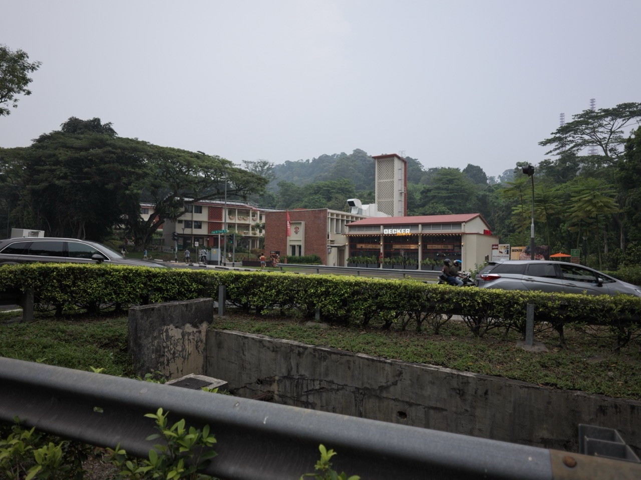
Did you know? The former Bukit Timah Fire Station could become much more than a handsome building beside Upper Bukit Timah Road. URA is positioning it as a gateway between Singapore’s railway heritage, nature trails and nearby forest parks. But the most interesting future feature—a proposed eco-pedestrian bridge—is not yet a crossing you can assume is open.
Quick answer, checked 24 October 2026: URA’s Rail Corridor plan, updated June 2026 says the fire-station site already gained a new community space for recreation, learning and co-living in 2025. A visitor centre and an eco-pedestrian bridge linking the node and Rail Corridor to Bukit Batok Nature Park are planned for the next development phase. URA’s page does not give a confirmed bridge opening date in 2027.
So the useful question for residents is not merely ‘When is the fire station reopening?’—part of its new life already exists. It is ‘When can this neighbourhood truly become an easier, safer place to begin a nature walk?’ The answer depends on a future link, the visitor centre, and how people move between landmarks.
A fire station that is no longer just a fire station
The familiar former station sits by Upper Bukit Timah Road, near Old Jurong Road. Its previous operational role ended years ago. The site’s architecture and history are now assets for adaptive reuse, which means keeping an existing place useful rather than replacing it simply because its first purpose has ended.
URA says the site has been transformed into a lifestyle and co-living hub, with community functions beginning in 2025. That matters in 2026 because parts of the transformation are already visible, while other connections remain plans. A photograph of the current site is not evidence that every proposed facility has opened.
If you are curious about the building’s earlier service history and conservation, see our dedicated former Bukit Timah Fire Station history guide. Here we focus on its changing role in the green network and what remains to be delivered.
The future visitor centre and eco-pedestrian bridge
Why place a visitor centre at a former fire station? A good gateway can teach people what they are about to see, how to travel carefully, which trails are suitable for different walkers, and why ecologically sensitive areas need protection. It also helps visitors understand that the forest is more than scenery.
URA’s June 2026 description says plans are underway for a visitor centre and eco-pedestrian bridge that would connect the node and Rail Corridor to Bukit Batok Nature Park. This is a planned connection. The exact access points, detailed design, user rules and opening date should be confirmed through later agency notices.
Imagine arriving from the MRT, finding a place to learn about wildlife and local history, then walking to a trail without needing to puzzle through multiple road crossings. That is the reader benefit of a well-designed gateway. It is an illustration of what a connected route can do, not an assertion that this complete itinerary exists today.
What is happening between now and 2027?
- 2025 milestone: the former fire station gained a community space for recreation, learning and co-living.
- June–October 2026: URA continues to describe a visitor centre and eco-pedestrian bridge as the next phase of development; it does not state that the bridge is in public operation.
- Into 2027: watch for design, worksite, access and opening updates. Treat 2027 as an information-and-progress watch period until a specific agency timeline is published.
- At eventual opening: check whether bridge access, the visitor centre and surrounding connecting paths become available together or in separate phases.
The map looks simple. The real-life journey may not be.
On a map, green spaces near each other often appear almost connected. On the ground, major roads, slopes, rail heritage structures and changing path surfaces can turn a short straight line into a much longer accessible route.
This is especially important to families using prams, people who need step-free paths and visitors with limited mobility. Future plans may show a bridge, but the pedestrian journey also depends on gradients, entrances, crossings and the facilities at either end.
In the meantime, the Rail Corridor is an existing, independently operated walking route with its own closures and access instructions. Use NParks’ current Rail Corridor visitor guidance when planning an actual walk.
Can architecture help nature?
It can, but the mechanism matters. A gateway can steer more people onto intended paths rather than informal forest shortcuts, offer environmental education and make access to suitable trails easier. At the same time, more visitors can increase crowding, litter and ecological disturbance if paths are poorly designed or rules are ignored.
The original URA fire-station rejuvenation announcement in 2021 discussed sustainable retrofitting, nature activities and adaptive reuse. A more recent URA green-transition overview also used the former station as an example of reducing building energy demand. These policy ambitions explain the intended design direction, but readers should not mistake old competition concepts for a verified inventory of features operating in 2026.
A small example: walking carefully through a green network
Suppose two friends want to visit the Rail Corridor and then Bukit Batok Nature Park. The temptation is to draw a straight line between them and call it a walking route. A safer plan begins with checking which segments are public and open, what official access points exist, and whether the trip requires crossing a road. The future eco-bridge may change that journey, but only after it opens.
Now consider a family that wants both a history stop and a nature walk. The ideal future gateway lets them build the trip around shared time and suitable distances. A visitor centre could make that easier by explaining what is nearby and why each trail deserves care.
Five details worth checking in 2027
- The bridge: its actual completion, public opening notice, entrances and accessibility, not just a picture in an urban plan.
- The visitor centre: the programme, operator, opening hours and any educational activities announced by the responsible agency.
- Trail conditions: fresh Rail Corridor and Bukit Batok Nature Park maps, diversions and safety notices.
- Connections: how visitors reach the hub from the existing Hume MRT station and nearby bus stops, without assuming newly planned sheltered routes are available.
- Conservation: which original building elements remain visible and how interpretation helps children understand changing community uses.
The wider significance for Bukit Timah
The old station tells a useful story about neighbourhoods. Infrastructure is built for one era. Transport, lifestyles and nearby communities change. The strongest places learn to reuse what already exists while opening new possibilities.
That approach is more thoughtful than treating the building as a photo stop. A restored landmark can anchor a place with its own identity, encourage visitors to care about nature, and distribute community activity beyond conventional shopping centres.
A future bridge will be important for the same reason. Its value is not only the structure itself, but the journey it makes easier—and the paths it might help protect from informal foot traffic.
Frequently asked questions
Is the former Bukit Timah Fire Station open to visitors now?
URA describes a community, recreation and co-living space that opened in 2025. Specific venues and activities may operate on different schedules, so check current operator information.
Will its eco-pedestrian bridge definitely open in 2027?
URA’s June 2026 plan describes the bridge as being in the next phase but does not specify a verified 2027 public opening date.
Where is the planned bridge supposed to connect?
URA describes a link involving the former fire-station node, Rail Corridor and Bukit Batok Nature Park.
Is the visitor centre already fully operating?
The 2026 URA plan identifies it as a planned next-phase facility. Do not rely on it as an open visitor service without a newer operator or agency announcement.
What should I use to plan a walk today?
Use NParks’ live park and Rail Corridor guidance for open segments and current conditions. The proposed bridge should not be used as a shortcut before it is officially open.
Primary sources and local background
URA: Rail Corridor community nodes, June 2026 · URA: former fire-station transformation concept · NParks: Rail Corridor access and closures · eduKateSG: site history and conservation.
Last fact-checked: 24 October 2026. The featured image shows the existing fire-station building, not the uncompleted visitor centre or proposed future bridge.
More in the Future of Bukit Timah series: Market and community building · Holland Plain homes and wetlands · Old Jurong Line and forest links. Earlier coverage: Turf City homes · Cross Island Line works · 2027 Rochor green walk · Upper Bukit Timah Canal.