
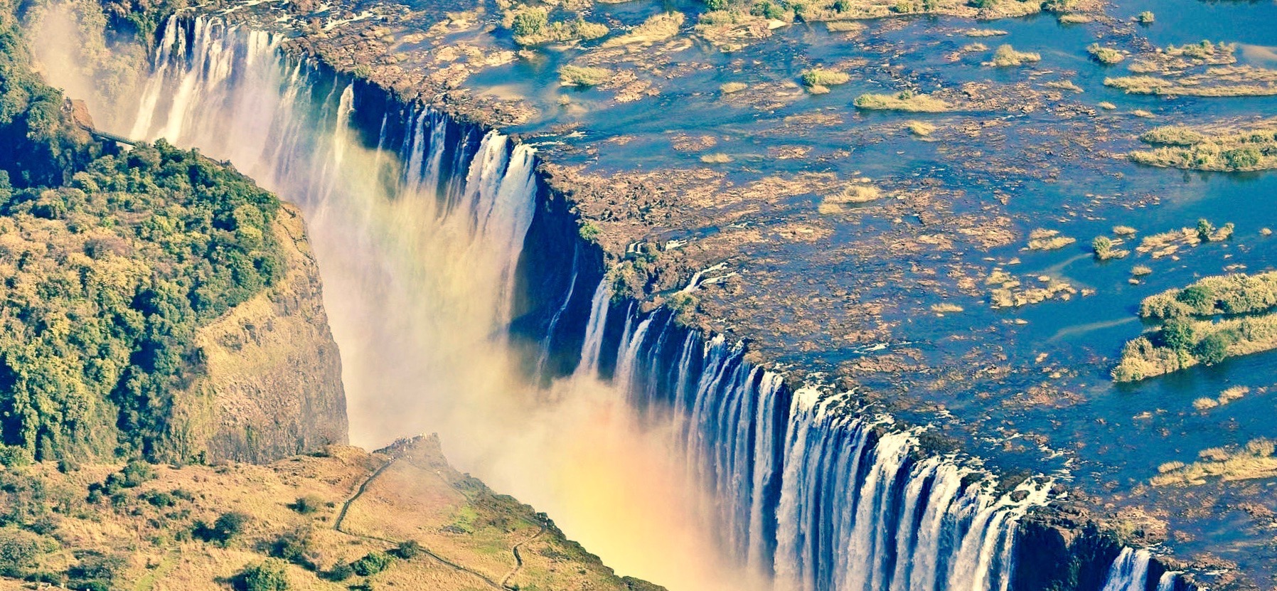
Where is Zambia, what is it famous for, and why is copper so important to the country? Zambia is a landlocked country in southern Africa, with Lusaka as its capital and the Zambian kwacha as its currency. It is famous for Mosi-oa-Tunya/Victoria Falls, the Zambezi River, wildlife landscapes, the Copperbelt and its mining history, and cultural traditions extending far beyond the visitor circuit. Zambia borders eight neighbours: Angola, the Democratic Republic of the Congo, Tanzania, Malawi, Mozambique, Zimbabwe, Botswana and Namibia. Copper connects Zambia to global manufacturing, energy technology and export markets, while rivers connect its farms, power stations, towns and ecosystems. To understand Zambia properly, you need both networks.
Everything about Zambia in one clear guide: start with its geography, the shared waterfall and Copperbelt, then connect how the country became independent in 1964, how the government operates, how money and trade reach households, why drought can cause power cuts and what schools, clinics and communities need every day. In August 2026, Hakainde Hichilema was re-elected president for a second term; in October the IMF reported fresh economic estimates and a staff-level agreement for a proposed programme. These developments are dated facts, not eternal descriptions. For specialists, the existing eduKateSG articles about government and services, copper mining, electricity and education take these questions further without requiring the overview to repeat entire specialist explanations.
Zambia at a glance: important facts and quick answers
- Official name: Republic of Zambia.
- Location: southern Africa; inland, without a national seacoast.
- Capital: Lusaka.
- Area: approximately 752,600 square kilometres.
- Eight neighbours: Angola, the Democratic Republic of the Congo, Tanzania, Malawi, Mozambique, Zimbabwe, Botswana and Namibia.
- Population: 19,610,769 recorded in the 2022 census; later estimates must be labelled by their reference year.
- Official language: English; many local languages, including Bemba, Nyanja, Tonga, Lozi, Kaonde, Lunda and Luvale, are spoken.
- Currency: Zambian kwacha (ZMW), divided into 100 ngwee.
- Time zone: Central Africa Time, UTC+02:00 year-round.
- Government: republic with an elected president, parliament, courts, national ministries and local councils.
- President as of October 2026: Hakainde Hichilema, re-elected in August 2026 for a second term.
- Administrative structure: 10 provinces, with districts and local-authority systems.
- Independence: 24 October 1964, from British rule over Northern Rhodesia.
- Largest economic themes: copper and other mining, agriculture, services, trade, infrastructure and tourism.
- Rivers and lakes: Zambezi, Kafue and Luangwa Rivers; lakes including Tanganyika, Mweru, Bangweulu and Kariba.
- World Heritage: UNESCO lists one inscribed site for Zambia: the natural transboundary Mosi-oa-Tunya/Victoria Falls property, shared with Zimbabwe.
- Common questions: why copper matters, why hydropower creates drought vulnerability, and how a landlocked country connects to world trade.
- Editorial date: 21 October 2026. A forecast is not a completed outcome, and a census is not a real-time population counter.
A word about the numbers: Zambia Statistics Agency maintains the census records; the World Bank reports the country’s economy and development needs; UNESCO maintains the current heritage list. Some older summaries use pre-election political facts or statistics measured several years earlier. The period and exact source matter as much as the number.
1. Where exactly is Zambia on the map of Africa?
Look just below the Democratic Republic of the Congo and above Zimbabwe. Zambia extends from the Angola border in the west towards Malawi and Mozambique in the east. The north reaches Tanzania, the south meets Zimbabwe and Namibia, while a very short southwestern border meets Botswana near Kazungula. The country has no coastline, but it is surrounded by important regional transport and trading relationships.
The word landlocked describes geography, not destiny. A Zambian mine can sell metal abroad without owning a national seaport. The product must travel to a port through another country, using roads, railways, border clearance and international shipping. Conversely, equipment, medicine, fuel and electronics purchased from overseas may arrive through neighbouring corridors. What matters is not just the distance to the sea but the reliability and cost of the whole chain.
Is Zambia in eastern, central or southern Africa?
Zambia is commonly classified within southern Africa and belongs to the Southern African Development Community, or SADC. Its geography and commercial relationships also connect it to Central and East Africa. Regional labels serve different statistical and political purposes. They are useful, but they are no substitute for identifying the actual neighbours, corridors and institutions involved in a question.
Why is the Zambia–Botswana border unusual?
The direct border near Kazungula is very short. The surrounding region brings Zambia, Botswana, Namibia and Zimbabwe close together near the Zambezi and Chobe river systems, though not all four share one single common international boundary point. The Kazungula Bridge links Zambia and Botswana, providing an important road transport connection. This illustrates how an apparently tiny border can carry economic significance through bridges, customs and trade facilitation.
How big is Zambia?
At around 752,600 square kilometres, Zambia has a large range of regional environments, though it is far smaller than the biggest countries on the continent. Area does not describe how long a journey takes. A road route can cross a river, a floodplain, highland terrain, a protected landscape and a busy border crossing. For practical geography, follow a particular journey rather than converting square kilometres into a guess about transport time.
A worked example: an export shipment from Zambia
Imagine a Copperbelt manufacturer needs to ship a metal product to an overseas customer. There is the factory, a quality check, a truck or train, a border, an international port and a ship. A document missing at the border can cancel the time saved by a faster truck. A new rail line can help only if the port and customs handover work. This example is hypothetical, but the supply-chain logic is real and central to understanding a landlocked economy.
2. What is Zambia’s landscape like beyond Victoria Falls?
Much of Zambia lies on a high plateau with river valleys and areas of wooded savanna. There are broad differences between wetter northern landscapes, the central and eastern highlands, and drier or hotter lower valleys. Its land cover and habitats include miombo woodland, wetlands, river corridors, farming areas, national parks and growing urban settlements. Zambia is neither one immense desert nor one continuous rainforest.
The Eastern and Northern parts of the country have important escarpments, waterfalls, forest and wetland systems. In the west, the Barotse Floodplain is associated with the upper Zambezi and seasonal water movements. In the south, the great river is part of a hydroelectric and ecological system shared with neighbours. Place names on a map become much more useful when you ask where the water flows and how people live with it.
Why are the Zambezi, Kafue and Luangwa Rivers important?
The Zambezi is a transboundary river system connecting Zambia with several neighbouring countries and eventually the Indian Ocean. The Kafue is a major Zambian tributary important for electricity, farming and ecosystems. The Luangwa River and its valley sustain distinctive wildlife and natural environments. Their roles differ, but all show that rivers are not just decorative lines: they link people, water security, farming, energy, conservation and international responsibilities.
A river can provide water for a power station without guaranteeing that every nearby household has safe tap water. Hydropower requires turbines and electrical networks; household water needs intake, treatment, testing, pumping, pipes and maintenance. The infrastructure and accountability behind each service must be considered separately.
Why are wetlands important in Zambia?
Wetlands such as the Bangweulu region and the Kafue Flats are ecological systems that support wildlife, vegetation, fisheries and communities. They can help regulate water, sustain livelihoods and provide important habitats. Their value does not make all uses identical or all ecological areas automatically protected under the same rules. Farming, conservation, fishing and infrastructure need locally appropriate decisions, including fair attention to communities who depend on the landscape.
In 2026, Zambia placed additional natural and cultural locations on its UNESCO World Heritage Tentative List, including Bangweulu Wetlands. A Tentative List entry means a site is under consideration for possible future nomination; it is not a World Heritage inscription.
Does Zambia have mountains?
Yes, though the country is best understood through its plateau, highlands and river valleys rather than by a single dominant alpine mountain chain. The terrain affects climate, travel, agriculture and ecology. The exact elevation of a place matters when comparing growing seasons or road conditions, but a national average altitude cannot predict what happens in every valley.
Worked example: why rainfall can help one community and harm another
Imagine an upstream catchment receives intense rain. Farmers in a suitable area may benefit from replenished soil moisture, while a low-lying downstream settlement may face flooding and damage to road access. A single rainfall total does not describe both outcomes. Planning needs catchment observations, drainage, early warning and real knowledge of where people and infrastructure are located.
3. Is Victoria Falls in Zambia or Zimbabwe?
Both. Mosi-oa-Tunya/Victoria Falls spans the Zambezi River at the Zambia–Zimbabwe boundary. On Zambia’s side, the falls are associated with the Livingstone area and Mosi-oa-Tunya National Park. UNESCO identifies the waterfall as a shared natural World Heritage property. It is celebrated for the immense curtain of falling water and the remarkable basalt gorges created through geological processes. It is not the world’s tallest waterfall, and “largest” only has meaning when the measurement is specified.
The river is more than two kilometres wide as it approaches the falls. UNESCO describes a curtain around 1,708 metres across, with waterfall sections dropping roughly 61–99 metres and the deepest point reaching 108 metres. Its mass of water and mist can be extraordinary, particularly when flows are high. These dimensions help explain why the place is famous without misrepresenting every season as identical. Read UNESCO’s Mosi-oa-Tunya/Victoria Falls dossier.
What does Mosi-oa-Tunya mean?
The name is commonly translated as “the Smoke That Thunders”, referring to the huge plume of spray and the sound of rushing water. Names and languages are parts of cultural geography, too. A historic colonial-era name and an indigenous name can refer to the same feature while carrying different histories and meanings.
Can a person see Victoria Falls from both countries?
Yes, views exist on both sides, but the visitor’s permitted access, trails and relevant entry rules differ. The border is an international boundary, not merely a bridge inside one park. A ticket for a viewpoint does not automatically establish immigration permission to cross into another country. Visitors should check current guidance, travel documents and their own insurance before planning both sides.
Why can the falls appear smaller during part of the year?
Flow changes seasonally because rainfall across a larger catchment affects the volume reaching the falls. Some portions of the cascade may be less active during low-water periods. That does not mean the landmark has disappeared or that high-flow photographs are fake. The useful comparison records both photographs’ dates, vantage points, and hydrological conditions.
Why are the gorges important?
Water has carved a distinctive series of gorges into basalt over geological time. The changing positions of the waterfall and erosion show that landforms evolve. The same area is also a living habitat, and UNESCO identifies protection needs associated with biodiversity and tourist infrastructure. An outstanding view does not absolve managers from maintaining trails, controlling pollution or carefully evaluating proposed developments.
What is the most important conservation fact?
World Heritage recognition acknowledges exceptional natural value; it is not a certificate guaranteeing that every tourism project is harmless. UNESCO’s management records describe the joint Zambia–Zimbabwe responsibilities and ongoing conservation questions. The official property record is the appropriate route for distinguishing the actual inscribed boundary from nearby places marketed with the World Heritage name.
4. What is the history of Zambia before and after independence?
The history of the land now called Zambia long predates its modern national border. Communities developed farming, metallurgy, regional trading relationships and political systems in differing environments. Later histories involve states and cultural traditions such as those associated with Bemba communities, the Lozi and Barotseland, Lunda-related societies, and many others. It is inaccurate to imagine that a modern colonial border can be read backwards as the boundary of every earlier polity.
European trading, missionary and colonial activities had major effects. British colonial institutions and commercial mineral development became especially important in the late nineteenth and twentieth centuries. The territory was known as Northern Rhodesia before independence. Copper mining profoundly shaped urbanisation, work, political organisation and international economic relationships.
- Earlier history: diverse communities and cultural traditions developed farming, metalworking, trade and political arrangements.
- Nineteenth century: changing regional political systems, trading networks and external interventions affected local societies.
- Colonial era: British authority shaped Northern Rhodesia, while mineral development changed employment and settlement.
- 1964: Zambia achieved independence on 24 October, with Kenneth Kaunda becoming its first president.
- 1972: Zambia adopted a one-party political system under Kaunda.
- 1991: multiparty electoral politics returned; Frederick Chiluba defeated Kaunda in that year’s presidential election.
- 2000s–2010s: copper-price cycles, infrastructure demands, changing parties in government and social-service pressures shaped development.
- 2020: Zambia defaulted on some external sovereign debt, setting up a prolonged restructuring process.
- 2021: Hakainde Hichilema defeated incumbent Edgar Lungu and became president.
- 2024: severe drought disrupted farming and hydropower, exposing the connections among weather, electricity, mining and household wellbeing.
- 13 August 2026: Zambia held presidential, parliamentary and local elections.
- 18 August 2026: the electoral commission announced Hichilema had won another term, with approximately 60% of the presidential vote.
- October 2026: attention remains on converting stabilisation, investment and public spending into broader jobs and dependable services.
For the independence date and colonial name, see the US State Department’s historical summary and Zambia’s Northern Provincial Administration history. The 2026 election outcome is reported by Reuters, while the EU observer mission records concerns and procedural observations. Dates of events and interpretation of them are separate matters.
Who was Kenneth Kaunda?
Kenneth Kaunda was a prominent Zambian independence leader and the country’s first president. His long period in office involved African liberation diplomacy, development efforts, political centralisation and a one-party system. Students should analyse both the achievements and democratic constraints of that period through sources appropriate to each claim. A person can be important to independence without every later policy being beyond criticism.
Why is the name Northern Rhodesia important?
Northern Rhodesia was the colonial name for the territory before independence. Changing a country’s name after decolonisation reflects a political and historical change, not the sudden creation of its people or cultures. In Zambia’s case, the new name references the Zambezi River. Reading the two names correctly prevents a history search from treating earlier documents as though they concern a completely different land.
What happened in 1991?
Zambia returned to multiparty electoral politics. Elections brought Frederick Chiluba to power after Kaunda’s long presidency. This is a defining milestone in the modern political system, but the quality of democratic practice is an ongoing question involving election administration, opposition rights, institutions, media and accountability. No single election settles every issue for the future.
Why did Zambia restructure its debt?
Debt can help finance useful investment, but repayment obligations can become unmanageable when revenues, prices, borrowing costs or fiscal decisions change. Zambia’s 2020 default led to negotiations with creditors and an extensive restructuring process. Reduced debt-service pressure can support other priorities, but the connection to services depends on future budgets, growth, implementation and effective institutions. Later reports should state how much debt was actually restructured and at what date, rather than claim that all obligations disappeared.
5. Who are the people of Zambia, and what languages do they speak?
Zambia is a diverse society with many language and cultural traditions. English is the official language used extensively in national administration and formal education. Major local languages or language groups include Bemba, Nyanja, Tonga, Lozi, Kaonde, Lunda and Luvale, with numerous other languages spoken. The languages people use can change between home, school, markets, media and work. Culture cannot be reduced to seven names or one national personality.
The Zambia Statistics Agency’s 2022 census provides a population baseline of 19,610,769. Different population projections for 2026 can be higher because they refer to later years and different methods. A reliable overview never substitutes a projected total for the last enumerated census while continuing to call it a census. See the agency’s population datasets.
Is Zambia an English-speaking country?
Yes, in the sense that English is its official language and is common in formal institutions. That does not mean every Zambian speaks English as a first language or that all citizens receive all services in their preferred language. A child may speak Bemba or Nyanja confidently at home and be learning academic English at school. Understanding this is crucial when interpreting classroom performance.
What languages are used in everyday life?
Language use varies by province, settlement, family and context. It is common to encounter Nyanja in Lusaka and Bemba in many Copperbelt and northern contexts, among many other combinations. The seven widely referenced Zambian language groups—Bemba, Nyanja, Tonga, Lozi, Kaonde, Lunda and Luvale—are relevant to education and broadcasting. The 2010 census language chapter explains the distinction between language grouping and ethnic identity.
What is the difference between a language and an ethnic group?
People may speak a language used by communities other than the one they identify with. Marriage, urbanisation, work and migration connect families. The Census Agency’s analyses explicitly warn that a language of communication is not identical to ethnic membership. Treating a language label as proof of a person’s ancestry, religion or politics is therefore a mistake.
Why does Zambia have a youthful population?
Zambia has a young demographic profile, with population growth creating an expanding demand for education, work, healthcare, housing and transport. A growing workforce could create opportunities if skills and productive jobs expand; otherwise many young adults may face difficulty finding secure work. The World Bank’s Zambia overview discusses this demographic pressure and the challenge of inclusive development.
A worked example: a family moves from one province to another
Imagine a pupil who reads fluently in a local language and is confident in mathematics, but moves to a school with different language expectations and a slightly different topic sequence. The pupil’s first difficulty may be terminology, not arithmetic. A good teacher compares the actual curriculum and gives a short diagnostic assessment before assuming the child is behind in every subject. This is an illustrative case, not a report about a named family.
6. How does Zambia’s government work in 2026?
Zambia is a republic with a directly elected president, National Assembly, ministries, courts and different territorial administrations. National policy decisions and the public services people experience are not the same thing: one requires legitimate authority and a budget; the other requires people, facilities, processes and accessible information. The country has ten provinces, divided into districts and other local governance arrangements.
Hakainde Hichilema won a second presidential term after the August 2026 election. The electoral commission’s results gave him around 60% of valid votes, while challenger Brian Mundubile won around 38%. The election involved a turbulent counting period and opposition allegations that deserve accurate attribution, not silence or assumptions of guilt. Reuters reported the certified outcome, and EU observers discussed the process and concerns. It is possible to describe the declared winner while separately acknowledging contested aspects of the election.
What are Zambia’s ten provinces?
Central, Copperbelt, Eastern, Luapula, Lusaka, Muchinga, Northern, North-Western, Southern and Western. Their economies, landscapes and population density differ. Some feature large cities and mining operations, some important farming areas, lakes, conservation regions or large distances between settlements. A province count says nothing by itself about how many clinics, schools or roads a district has.
What does a local council do?
Councils have municipal and district-related functions subject to the relevant legislation, budgets and administrative arrangements. A road, waste collection issue, planning permit or market facility may involve a local authority, while another service belongs primarily to a national ministry or utility. The practical first step is to identify the exact type and location of the service rather than simply write to the most senior office in the country.
Why do public budgets matter?
A policy can promise something worthwhile and still fail at the delivery stage. An education allocation needs timely funding, teachers, materials and schools. A water project needs maintenance, testing and accountable operations after construction. A road requires drainage and repairs, not only a ceremonial opening. The person at the end of the chain is the best test of whether a national programme becomes useful.
Can Zambia’s election results and opposition concerns both be reported fairly?
Yes. The electoral commission’s declared result establishes who was announced as the winner. Separately, documented electoral incidents, observer observations, opposition objections and legal decisions deserve consideration according to their evidentiary status. Allegations are not automatically proven outcomes, nor should they be hidden simply because a result was officially declared. A country atlas should state dates, sources and institutional processes without campaigning for either side.
7. Why is Zambia associated with copper and the Copperbelt?
Copper is central to Zambia’s modern economic identity because the country has major copper deposits and a long mining history, especially in the Copperbelt and newer mining regions in North-Western Province. Copper is essential for electrical conductors, building systems, motors, transformers, renewable-energy equipment and other industrial applications. International demand affects export earnings and investment. Yet the geology alone does not provide employment and prosperity: mines need equipment, electricity, water, trained workers, legal oversight, transport and markets.
A mineral economy creates multiple chains. Geologists study deposits; companies develop mines; workers extract ore; plants process it; power systems run machinery; trucks and railways carry metal to buyers; government collects taxes and royalties; and households experience wages, public spending and environmental consequences. Keeping those chains visible is more accurate than describing copper as money that simply comes out of the earth.
What is the difference between copper ore, concentrate and refined copper?
Ore is rock containing minerals from which copper may be extracted. After crushing and concentration, some operations produce material with a higher copper content—concentrate—requiring further processing. Smelting and refining can lead to copper products of sufficiently high purity for industrial use. Some mining operations employ different processing routes depending on their geology. The distinction matters because export tonnage, price, employment and processing capacity differ at each stage.
Why is Zambia’s copper linked to electrification?
Copper has high electrical conductivity and is used widely in power and electronic infrastructure. More grids, motors, electric vehicles and renewable-energy equipment can increase demand for copper. Demand forecasts are scenarios, not promises that a particular mine will be profitable. Investment depends on prices, production costs, reliable electricity, financing, community relationships, environmental obligations and market competition.
How much copper does Zambia produce?
Production varies by year. Reuters reported about 890,346 metric tonnes for 2025 and described national ambitions to reach around three million tonnes annually by 2031. Those are a measured past production figure and a future target, not the same fact. Zambia’s actual 2026 output must be assessed through published mining statistics and company reports once the period is complete. See Reuters’ June 2026 industry report.
Why doesn’t copper wealth automatically end poverty?
Commodity prices fluctuate and large industrial facilities can generate high export value without directly employing a large share of the population. Government receipts depend on taxes, operating results and fiscal rules. Communities near mines may face costs involving water, air, land or displacement that require strong safeguards. The quality of jobs, local procurement, transport links, education and public spending ultimately determines whether resource value spreads more widely.
What is the most useful way to measure mining success?
Do not choose one number. Look at the amount produced, net earnings, worker conditions, environmental performance, tax paid, local suppliers, infrastructure reliability and how households and communities benefit. A target for tonnes of copper can encourage investment, but it does not substitute for evidence of sustainable economic and social outcomes.
Follow the specialist copper guide
The companion How Zambia Works | Why Is Zambia Rich in Copper? Mines, Exports and Jobs covers the geology, mining stages and export systems in greater detail. This page provides the broad country context and connects that specialist analysis to Zambia’s geography, schools, government and everyday life.
8. Why does Zambia experience power cuts when it has big rivers?
Zambia produces much of its electricity from hydropower, particularly stations associated with the Kafue and Zambezi systems. Hydropower needs water moving through operating turbines, and the amount of water available can vary with rainfall, reservoir rules, competing uses and climate conditions. A country may have an impressive dam but still experience electricity shortages if there is insufficient usable water or other problems in generation and the grid.
Electricity must satisfy demand whenever customers want to use it. Factories, mines, hospitals, schools, water pumps, shops and homes all need power. When generation, imports or transmission cannot meet demand, controlled interruptions called load shedding may be used. A blackout may also occur because of equipment failure or local damage; those two events are not always the same. The specialist Zambia power-cuts guide explains the physical and administrative mechanisms.
What are Kariba North Bank and Kafue Gorge?
Kariba North Bank is a Zambian hydropower station using water from Lake Kariba, which Zambia and Zimbabwe share through their relationship to the dam and river. Kafue Gorge and other facilities on the Kafue system also generate electricity. These projects depend on working turbines, intakes, transformers and high-voltage transmission networks. The presence of a station on a map is not proof that it is generating at full capacity at a particular hour.
How does drought affect Zambia’s mines and homes at the same time?
Less usable reservoir water can reduce hydroelectric generation. A mine may then need alternative power, reduce some operations or invest in backup arrangements. A household may experience power cuts, while a clinic needs protected medicine storage and a small shop needs refrigeration. Water scarcity therefore becomes an economic and public-health concern, not only an environmental headline.
The World Bank’s April 2026 climate-and-development report specifically describes drought risks affecting agriculture, hydropower and incomes. That is a causal relationship supported by evidence, but it is not proof that the same severity of shortage exists every month.
Is Lake Kariba full again in 2026?
Lake levels change continuously, and a quoted figure belongs to its observation date. On 16 September 2026, the Zambezi River Authority reported Lake Kariba at approximately 481.21 metres and 40.89% of its usable storage under the authority’s defined operating range, compared with 17.26% on the corresponding date in 2025. That is a meaningful year-on-year improvement in the particular measure. It does not mean that every power cut across Zambia had ended. Read the Zambezi River Authority’s dated September 2026 table and current operational releases when making a live assessment.
What happens if water levels improve but electricity remains unreliable?
The grid may still face maintenance problems, damaged lines, generation limits outside Kariba, transmission bottlenecks or imbalances between demand and available supply. It takes time to rebuild reserves and investment capacity after a severe drought. A full answer needs updated data from the power producers, ZESCO and the relevant regulator, not just one lake photograph.
How can solar and other sources help?
Additional sources of electricity can reduce dependence on one water system, subject to the costs and technical constraints of each technology. Solar generation may be available during daylight but needs grid management and potentially storage or complementary supplies for evening demand. Reliable power requires a portfolio of sources, adequate networks, maintenance and payment arrangements. Installed capacity and delivered energy should not be confused.
An illustrative example: one outage affects five systems
Imagine a three-hour electricity disruption. An irrigation pump stops, a small food processor cannot run its machine, a school loses internet access, a hospital tests its backup supply and a metal workshop misses a delivery deadline. One power problem crosses agriculture, industry, education, health and trade. This is a hypothetical scenario, not a record of a particular outage. The practical solution is to improve overall grid reliability while giving essential services suitable resilience plans.
9. How does Zambia’s economy work beyond copper?
Mining is prominent, but agriculture, finance, wholesale and retail trade, construction, hospitality, public services and many other activities create livelihoods. A country producing more copper does not automatically mean that every shop makes more money, that transport becomes cheaper or that young workers can find suitable jobs. Economic health depends on how national production becomes employment, purchasing power, public infrastructure and stable opportunities.
As of 9 October 2026, the IMF reported that its staff had reached an agreement in principle on a proposed new Extended Credit Facility programme, subject to management approval and executive-board consideration. Its staff projected real GDP growth of about 5.6% in 2026, supported by agriculture, mining and exports; reported inflation at 6.1% in September 2026; and said gross international reserves stood at US$6.1 billion in September. These are specifically dated estimates, reported results and a programme negotiation milestone—not a guarantee of future performance or confirmation that the proposed programme already had final board approval. Source: IMF, 9 October 2026.
What does an IMF staff-level agreement mean?
It means IMF staff and the authorities reached an understanding on a programme or policy package, but further formal steps are required. It should not be described as the same thing as executive-board approval or a completed disbursement. Likewise, a forecast for 2026 cannot be treated as an audited final annual result while the year is still in progress. Readers who only want a simple answer should remember: announced agreement, approved programme and delivered funding are different stages.
Why do lower inflation and growth not guarantee comfortable living?
Growth measures economic output; inflation describes changes in price levels. A family experiences income, bills, access to water, transport costs and job security. If real economic activity grows while household expenses remain high, people may still find it difficult to save. If inflation falls from a high rate, prices may still be increasing, just more slowly.
Imagine a monthly basket that costs 1,000 kwacha, rises to 1,200 and then rises to 1,260. The inflation rate has fallen from 20% to 5% in the example, but the basket has not returned to 1,000. This is an arithmetic illustration, not a quotation of Zambian prices. It demonstrates why good economic reporting should not claim that a lower inflation rate means all living costs have fallen.
What is the kwacha, and why does its value matter?
The Zambian kwacha is the national currency, abbreviated ZMW. People use it to pay wages, buy goods and settle many domestic transactions. Exchange-rate movements can affect imported machinery, fuel, fertilizer or other inputs priced internationally. Export companies and indebted borrowers may face different effects. The rate that matters for a real transaction is the legally applicable rate and terms at that time, not an old screenshot or invented conversion.
Why is debt restructuring important?
Zambia faced severe debt difficulties and a sovereign default in 2020. Debt restructuring changes obligations and can reduce future repayment pressure under agreed terms. That may improve space for public spending or strengthen confidence, but it does not eliminate the need for sound budgets and productive investment. A country can make progress on debt while still needing jobs, skills, reliable power and poverty reduction. The World Bank’s 2026 overview discusses the restructuring and remaining development needs.
Why do ordinary businesses need financial infrastructure?
A grower may have a market but need a short-term working-capital facility to buy seeds. A shop may have customers but need reliable digital or bank payments. A workshop may need a loan for a more efficient machine. Finance works best when conditions, repayment obligations and protection against fraud are understandable. A published credit programme does not help if suitable people cannot actually access it.
10. What does Zambia farm and eat, and how does agriculture affect prices?
Maize is central to farming and many everyday meals, but Zambia also produces other crops, keeps livestock and has fisheries and food-processing activities. Regional farming includes cassava, groundnuts, legumes, vegetables and other products suited to local conditions. The rainy season, soil quality, seed availability, irrigation and transport all affect output. Food availability is a combination of production, storage, distribution and people’s ability to pay.
The World Bank’s country reporting says the 2026 recovery was supported by improved agricultural activity and a large maize harvest reported in May 2026. A national harvest figure is useful but incomplete: it does not tell us whether each district had enough food, whether produce was stored safely or what households paid. The World Bank’s Zambia reporting and national agricultural releases should be used for the relevant period.
What is nshima?
Nshima is a thick maize-meal preparation widely associated with Zambian meals. It is often served with vegetables, beans, fish, meat or other accompaniments, depending on household and regional preferences. Other grains and starchy foods have their own traditions. It is better to say nshima is an important staple than to claim every person eats it in the same way or at every meal.
Food is also a lesson in national systems. Growing maize requires a suitable season and farm inputs. Processing it requires equipment and energy. Reaching a market needs transport. A family needs income to buy it, and safe cooking and clean water help turn the food into a healthy meal. A simple plate of nshima therefore connects agriculture, infrastructure, labour and household finances.
Why does fertilizer matter to a farmer?
Fertilizer can help replenish necessary soil nutrients where appropriate, but it has costs and requires sound agronomic decisions. Availability, price, timing, water, soil testing and transport influence its usefulness. Fertilizer support cannot replace attention to soil health and market access. A farmer may buy enough fertilizer and still struggle if the crop fails from drought or the harvest cannot be sold at a viable price.
What is the difference between national food output and food security?
The first measures food grown or supplied. The second includes physical access, affordability, nutritional adequacy and stability. Even when markets have maize, some families may lack sufficient income to buy enough of it or to maintain a diverse diet. A drought can affect both food production and household earnings, while transport problems can create local shortages without nationwide crop failure.
A worked example: why a good harvest may still lose money
Imagine a farmer producing a larger crop than last year. If the market price drops and transport charges rise, the farmer’s net earnings may not rise. If there is no safe storage, the farmer may be forced to sell immediately, even when a later price would be better. This is a hypothetical example, not a reported Zambian farmer’s accounts. It shows why measuring yields alone is not enough to evaluate rural livelihoods.
11. What is the Lobito Corridor, and why could it matter to Zambia?
The Lobito Corridor is a multinational transport and economic-development effort connecting Angola’s Atlantic port of Lobito with parts of the Democratic Republic of the Congo and Zambia’s Copperbelt-related economy. Its aim is broader than moving mined metal: road and railway systems, trade facilitation, border procedures, agriculture, energy and other services all influence whether the corridor delivers benefits.
On 6 August 2026, the African Development Bank announced a US$255 million loan and a US$10 million grant supporting Zambia’s participation in a phase of the integrated corridor initiative. The finance announcement was a real milestone but did not mean every planned Zambian railway extension was already finished. Read the African Development Bank’s dated release and its June 2026 appraisal for the planned components.
Why would a new export route help a landlocked country?
A competitive route may reduce transport time, lower logistics costs or offer an alternative when other corridors experience congestion or disruption. Yet cost depends on the entire journey: local roads, rail handovers, customs, port capacity, insurance and vessel schedules. A new line of track is valuable only if shippers can actually book and use it dependably.
Is the Lobito Corridor only for copper?
Mining is a major reason for investment, but the project’s development concept also includes agriculture, trading towns, energy connections and industry. A farming cooperative could benefit from better access to buyers—but only if freight services are available at a suitable scale and price. The existence of a regional corridor does not automatically grant small businesses affordable transport.
Why is it important to distinguish construction from operation?
An approved loan is not a completed road; a refurbished railway in one country is not automatically an uninterrupted rail route across several countries. For a proper status report, check which segment is funded, which is being built, which is operational and which cross-border permits or customs agreements have been implemented. Project milestones belong on a timeline, not inside a vague statement that “the railway is open.”
An illustrative shipment through the corridor
Imagine a metal-processing company in Zambia loading finished products for an overseas customer. It must arrange a truck or train from the factory, transport through the connecting territory, the correct border documents, safe storage at the port and an onward ship. If a customs handover takes two days longer than expected, faster trains elsewhere may not offset the delay. Trade infrastructure works when the connections are reliable.
12. How do Zambia’s cities and transport networks connect ordinary life?
Lusaka is Zambia’s capital, an administrative and business centre, and a growing urban area. Ndola and Kitwe are important Copperbelt cities connected to mining and industry. Livingstone is associated with Mosi-oa-Tunya/Victoria Falls and tourism. Other towns serve transport, farming, education, government and regional commercial functions. Rankings of city sizes must use a defined area and reference date: municipality, urban district and metropolitan region are not necessarily the same thing.
A city functions through more than buildings. Families need housing, affordable food, water, sanitation, electricity, health services, classrooms, workplaces, public transport and streets that remain usable. A beautiful shopping district cannot represent every neighbourhood; an image of traffic congestion cannot prove an entire capital lacks functioning roads.
Why does Lusaka matter?
National institutions and many commercial activities are concentrated in Lusaka. That concentration creates jobs and access to services, but it also creates pressure on land, transport, drainage, housing and urban infrastructure. A family commuting across the city experiences the combined system rather than individual departments. The useful measures include actual travel times, affordability, safety and consistency.
What is special about the Copperbelt cities?
They grew through connections to mining, processing and associated industries. Their residents work in many more occupations than mining alone, including education, shops, healthcare and public services. Commodity cycles can affect local demand and employment, so building diverse firms and reliable infrastructure is important to their long-term resilience.
Why is Livingstone important beyond the waterfall?
Livingstone is a settlement with residents, schools, commerce and public institutions as well as an international visitor role. Tourism adds customers and jobs but also creates pressures on roads, conservation and public amenities. A functioning visitor economy should support communities and protect the ecological values that draw people to the area.
What happens when a bridge is closed?
Imagine a bridge linking a farming district to a regional market needs urgent repairs. Trucks may take longer routes, school journeys may be disrupted and medical referrals delayed. The bridge is not merely a piece of concrete: it is a link in several social and economic chains. Planning must include alternative access and honest communication while maintenance is carried out. The scenario is fictional but illustrates a genuine infrastructure dependency.
13. How does Zambia’s education system work in 2026?
Zambia has early childhood, primary, secondary, technical and higher-education pathways. The qualification and grade names that students encounter depend on the curriculum reform schedule, the cohort and the examination authority. Many families are familiar with Grade 7, Grade 9 and Grade 12 milestones, but it would be misleading to assume that every learner in 2026 follows an unchanged historical assessment structure. Reform is being introduced across cohorts, and the receiving school or qualification authority must confirm the precise current rules.
The government’s free-education policy has expanded access to public schooling. However, the price of entry is not the only barrier to learning: textbooks, teachers, classroom space, sanitation, transport, disability support and household finances also matter. The Ministry of Education’s 8 July 2026 clarification distinguishes the older legal recognition of free education from practical policy implementation and financing. A parliamentary 2026 Education Amendment Bill proposed further legal protections and system changes; a bill should never be described as law solely because it has been introduced.
Is public school free for every child?
The policy of free public education aims to reduce school fees and expand access, but families should verify what is provided, what documents are needed and whether other legitimate household costs remain. Free tuition does not automatically include every transport, boarding, uniform or other expense. And a policy cannot guarantee that a teacher is available in every subject at every school.
Who manages Zambian school examinations?
The Examinations Council of Zambia (ECZ) plays a central role in national examinations and certification. A family should check the exact qualification, examination year and candidate status using the current ECZ guidance rather than relying on a past paper or an older school-stage chart. A certificate may be used for progression, but a university or employer also needs subject requirements, grades and verification.
What does primary education need beyond an enrollment figure?
Reading, mathematics, age-appropriate instruction, capable teachers, learning materials, accessible classrooms and regular attendance are all necessary for strong foundations. UNICEF’s Zambia education programme discusses the opportunity created by broader access and continuing difficulties with early learning. A count of pupils registered does not demonstrate what each learner can read or solve.
How should parents compare school or tutoring systems?
First identify the learner’s current grade and syllabus, whether the curriculum has changed, the language used in class, the next assessment and the child’s actual errors. A parent moving between countries should gather records and seek confirmation from the receiving institution. A qualified tutor should diagnose exact gaps, teach from first principles and ask the student to explain thinking, rather than promise examination success from a generic set of worksheets.
The established eduKateSG Zambia education system guide covers mixed-cohort progression and recognition. The Zambia mathematics-tutor guide focuses on evaluating targeted support. They retain their own purposes within the wider country library.
Worked example: two children with the same grade label
Imagine two learners called Grade 9 students, one under an earlier assessment pathway and one in a transition arrangement. Both may have studied similar subjects, but requirements for certification or progression could differ. The correct choice is to check the actual cohort and current school document rather than assume a grade number proves identical qualifications. This case is illustrative and does not assert which specific 2026 cohort faces which formal examination.
14. How do healthcare, water and sanitation work in Zambia?
Healthcare depends on much more than the existence of a building marked “clinic”. Qualified staff need medicines, electricity, clean running water, diagnostic and referral systems, reliable records and safe transport. The population needs clear information, affordable access and the ability to return for follow-up. A remote health post and a specialised urban hospital provide different services, and neither can replace every role of the other.
Safe water involves locating a source, protecting it from contamination, treating where necessary, testing, storing and distributing the supply. A borehole or pump can be important while still needing maintenance; a pipe connection can exist without continuous service. Water and sanitation affect diarrhoeal disease risks, school attendance, child health, food preparation and the time families spend on household work.
Why does a drought increase health and education risks?
Reduced water availability may increase collection time and pressure on household hygiene. Farm income may fall and food become less affordable. If hydropower output also declines, electricity-reliant services face additional constraints. A school can lose teaching time when facilities are unsafe or children need to collect water. The World Bank climate-and-development analysis traces these interconnections.
Why does flood preparedness matter as much as drought preparedness?
Drought and heavy rain need different precautions. An area with steep or poorly drained ground may face flash flooding, while floodplains can experience seasonal inundation. Drainage maintenance, resilient housing, warning systems and safe bridges matter when water is abundant at the wrong place or time. A water-management strategy cannot focus only on building storage and ignore the safe movement of floodwater.
Worked example: one hour spent fetching water
Imagine a child or caregiver spending an extra hour obtaining water because a local pump has failed. That hour must come from study, paid work, rest or care. The repair therefore has value beyond the litres delivered. This is a hypothetical household, but it shows why public-service performance must include time, reliability and human dignity alongside construction statistics.
15. What is Zambia famous for culturally?
Zambia’s cultural life includes many languages, music, dance, family and community traditions, food, crafts and ceremonies. It is not accurate to describe every resident through one costume, religion or festival. Communities have their own histories, while cities and families combine traditions in changing ways. Modern music, contemporary literature, faith communities, entrepreneurship and everyday social life are as much part of Zambia as historic ceremonies.
The diversity of recognised languages provides a clue. A phrase spoken in Bemba does not automatically have an exact cultural counterpart in Tonga or Lozi. A festival connected to one kingdom or area should not be presented as if it belongs to everyone identically. Good cultural reporting credits the community and the context while making it clear that individuals may participate in different ways.
What is Kuomboka?
Kuomboka is a significant traditional ceremony associated with the Lozi people and seasonal floodplain life in western Zambia. It is commonly connected with the movement of the Litunga, the Lozi king, from the floodplain to higher ground as waters rise. The ceremony gives readers a useful example of geography and culture operating together: annual river rhythms, boats, leadership traditions, music, community organisation and living heritage meet in one event.
Dates and arrangements depend on present conditions and official organisers. A historic account of the ceremony does not establish its exact date in a future year. The safest learning approach is to distinguish the long-standing cultural meaning from the current event schedule.
What about other ceremonies?
Zambia contains numerous ceremonies, performances and commemorations associated with different communities. Examples widely discussed in national cultural guides include Nc’wala among Ngoni communities and Ukusefya Pa Ngwena among Bemba communities. Their meanings and traditions should be described through reliable accounts and community voices, not presented as identical celebrations with different costumes.
What is Zambian music like?
Zambia has many musical traditions and contemporary styles, including genres that developed through urban popular culture, gospel, dance music and earlier bands and recording scenes. A musical instrument is an object, while knowledge about performance, composition, rhythm and community meaning is held by people. Learning about a tradition should include who practises it and how it changes.
What is everyday Zambian food?
Nshima is prominent, usually accompanied by different relishes. Vegetables, groundnuts, fish, meat, beans and other ingredients vary by family and region. Kapenta—small fish commonly associated with Lake Kariba and other fisheries—appears in some meals and markets. Food links crops, fishing, environmental management, trade, cooking fuels and household budgets. It is better to explain those connections than offer one supposedly universal national menu.
16. Which animals, parks and ecosystems make Zambia distinctive?
Zambia has recognised wildlife and conservation landscapes, including areas associated with South Luangwa, Kafue, Lower Zambezi, Kasanka, Liuwa Plain and other parks and reserves. Different ecosystems support different species and habitats; a photograph of elephants cannot stand for every park, and a list of wildlife species does not prove that visitors can see them on demand. Current park management, environmental conditions and relevant permissions need to be checked separately.
Conservation is also about people. Communities need safe land use, livelihoods and ways to manage human–wildlife conflict. Protected areas need skilled staff, reliable funding, monitoring, rules for visitors and careful decisions about tourism development. A healthy landscape has value beyond foreign tourism revenue, including water systems and biodiversity.
Why is South Luangwa important?
The Luangwa Valley is associated with extensive wildlife habitats, river systems and tourism. Its importance is ecological as well as economic. Seasonal changes can affect roads, wildlife movement and river conditions. The right question is not simply “what species are there?” but how habitats, water and the surrounding communities remain healthy.
What is Kafue National Park?
Kafue is a major national park associated with diverse habitats and ecological processes. It shows that Zambia’s natural heritage is not confined to the waterfall or a single river. Conservation management needs data about landscape change, pressures and effective protection, not just visitor numbers.
Is the Lower Zambezi a UNESCO World Heritage Site?
As of October 2026, Zambia’s official World Heritage list contains just one inscribed property: Mosi-oa-Tunya/Victoria Falls. Lower Zambezi National Park and several other Zambian locations appear on the country’s 2026 UNESCO Tentative List. A Tentative List entry means potential future nomination, not present inscription. This distinction is important when using labels in school research or tourism copy. Verify against UNESCO’s Zambia country register.
Why do habitats and farming sometimes compete for the same land?
People, wildlife, rivers and crops can depend on overlapping areas. A conservation plan may need to protect habitat while helping households manage crop damage, livestock risks and access to resources. Excluding residents from the discussion can undermine both conservation and livelihoods. The best solutions consider ecological evidence, fair consultation and the actual people affected.
17. How does climate change affect Zambia’s future?
Climate change creates long-term challenges that are already relevant to Zambia’s infrastructure, food and energy systems. Heat, rainfall variability, severe drought and some flood risks affect farming, water supply and hydropower. Poor and rural households may be particularly exposed where income depends on rain-fed agriculture or reliable public services are difficult to reach. The World Bank’s April 2026 country climate report describes these risks and opportunities for resilient growth.
Good adaptation takes multiple forms. Farmers may benefit from better information, resilient crops where appropriate, soil and water management, reliable markets and financial safeguards. Power systems need diversified supply, maintenance and appropriate storage. Towns require drainage, safe buildings and preparedness. Environmental protection and household prosperity are connected, not competing headings in a report.
Can a country solve its climate problems by planting trees alone?
Trees and healthy ecosystems can contribute in important ways, but drought-resistant infrastructure, water governance, energy planning, urban drainage, agriculture and wider emissions policies remain necessary. Planting without matching species to habitat and providing maintenance may not deliver the intended ecological benefits. The question is what problem a particular project solves and how success is measured.
Why does regional cooperation matter for water?
The Zambezi’s catchment extends across several countries. Upstream rainfall, shared reservoirs, protected areas and water withdrawals can affect downstream communities. Hydropower and flood-management decisions also require coordination across borders. A national boundary is a legal division, but a watershed is a physical system.
Worked example: adapting a farming and power system together
Imagine a district that wants to support irrigation and a small local industry. Water must be used sustainably, and the industry needs reliable energy. If a solution increases electricity availability by consuming scarce water at the wrong time, it may undermine farming; if irrigation is expanded without markets, the new production may not generate adequate income. Integrated planning tests water, energy, land, financing and livelihoods together. This scenario is illustrative, not a proposed project at a named location.
18. Is Zambia safe to visit, and what should travellers know?
Zambia has attractions of cultural, ecological and historical interest. But the fact that a place is renowned does not tell a particular traveller what they should do today. Entry requirements, accommodation, medical considerations, insurance, transport, weather, park permissions and the current security situation must be assessed separately. A country guide is an educational reference, not a live itinerary or an assurance of safety.
For Victoria Falls, remember that Zambia and Zimbabwe remain two different countries with their own immigration requirements. A viewpoint in one country does not create permission to cross into the other. River conditions and operating arrangements can change seasonally. Consult current UK FCDO advice for Zambia, your own government’s guidance, and the appropriate operators or park authorities before an actual journey.
Is tourism important for local economies?
Yes. Accommodation, guides, transport, food suppliers and many other businesses may benefit when visitors spend locally. But visitor activity also creates pressures on waste, water, roads and nature. Long-term value comes from safe experiences, fair community benefits and environmental stewardship. UNESCO’s records on the shared waterfall emphasise the importance of compatible management and responsible development.
What should a student learn from a visit without travelling?
Geography, geology, history and economics can be studied from reliable maps, heritage records, videos, scholarship and reports. A student can compare seasonal images of Mosi-oa-Tunya, trace copper’s journey into everyday objects, or investigate how water helps and constrains electricity production. The existing Zambia places guide provides a destination-focused starting point alongside official conservation evidence.
19. What connects Zambia’s resources, government and daily life?
Imagine a household in a provincial town with one adult employed by a small shop, another growing food in a nearby village and a child preparing for school examinations. Copper exports can shape national economic conditions, but the household’s immediate experience involves the price of food, reliable power, an affordable commute, school materials and a safe water supply. The family experiences these things as one connected week, not as separate ministries.
Now imagine a drought reduces power generation while making the farming season less dependable. The shop struggles with refrigeration, crop sales weaken, household income tightens and the student has less time or reliable light to study. This is an illustrative household, not a survey of an actual family. It shows why a country should be studied as a system of linked opportunities and constraints.
Which measurements best indicate that public systems work?
Look at outcomes that reach people: reliable water at a tap, travel time on an actual route, how frequently electricity is available, whether children can read and progress, safe access to clinics, the purchasing power of income and whether businesses can trade. National totals are useful but can hide differences between provinces, districts and households.
What can Zambia teach readers studying Singapore?
Zambia and Singapore have very different geography and history. Singapore’s urban transport and seaport systems differ from Zambia’s river basins, mines, inland agricultural routes and dependence on neighbours for maritime access. A comparison is valuable when it reveals how infrastructure, institutions, training and households connect—not when one country’s arrangements are treated as a universal model. See the separate How Singapore Works | Civilisation library and its roads, expressways and junctions guide.
20. Frequently asked questions about Zambia
Is Zambia a country in Africa?
Yes, a sovereign, landlocked country in southern Africa. It became independent from Britain on 24 October 1964.
Where is Zambia?
South of the Democratic Republic of the Congo, north of Zimbabwe, and inland from Africa’s eastern and southern coasts, with eight neighbours.
What is Zambia’s capital city?
Lusaka. It is a centre of government, commerce and population, though it is not representative of every province.
Is Zambia the same country as Zimbabwe?
No. They are neighbouring sovereign states. They share Mosi-oa-Tunya/Victoria Falls and important river systems but have separate laws, currencies and national institutions.
Who owns Victoria Falls?
It is a transboundary natural heritage property spanning Zambia and Zimbabwe, with different national management responsibilities. It cannot be described as belonging wholly to just one side.
Is Victoria Falls the tallest waterfall?
No. Its significance lies in the immense sheet of falling water, the dramatic gorges and its natural processes. “Largest” and “tallest” are different measurement claims.
How many UNESCO World Heritage Sites does Zambia have?
One inscribed property as of October 2026: Mosi-oa-Tunya/Victoria Falls. Additional sites appear on the Tentative List but are not yet inscribed.
Why is Zambia famous for copper?
It has major copper resources and a long mining history. Copper supports exports, investment and many industries, but its benefits depend on economic and public-service systems.
What is the Copperbelt?
A region strongly associated with copper mines and mining towns. Mining activity also extends into other parts of Zambia, including North-Western Province.
Who is Zambia’s president in October 2026?
Hakainde Hichilema, re-elected in the August 2026 election. The electoral process and subsequent questions should be described using dated official and independent evidence.
What is the population of Zambia?
The 2022 national census recorded 19,610,769 people. A 2026 population estimate is a projection for a later date, not a second census.
How many provinces does Zambia have?
Ten: Central, Copperbelt, Eastern, Luapula, Lusaka, Muchinga, Northern, North-Western, Southern and Western.
What language do Zambians speak?
English is the official language. Bemba, Nyanja, Tonga, Lozi, Kaonde, Lunda and Luvale are among important local languages, alongside many others.
What currency does Zambia use?
The Zambian kwacha (ZMW). Its current value depends on market and official conditions and should never be inferred from an outdated conversion example.
Why does Zambia have power cuts?
Its energy system has relied heavily on hydropower, which is sensitive to water availability. Maintenance, networks, supply and demand also matter.
Is Lake Kariba full now?
Do not infer a current level from an old photograph. The Zambezi River Authority provides dated lake readings, and a September 2026 result cannot establish today’s condition.
Does Zambia have a coastline?
No. It is landlocked. Its trade depends on overland transport and access through neighbouring countries’ ports.
What is Zambia’s independence date?
24 October 1964, with Kenneth Kaunda as the first president.
What is the Lobito Corridor?
A regional economic and transport initiative that connects Zambia and the DRC with Angola’s Atlantic port of Lobito. Funding and planned links are not the same as completed, operational services.
Is primary and secondary school free?
Zambia has an expanded free-public-education policy. Actual charges, eligibility, costs and current reforms must be checked against official guidance rather than presumed identical everywhere.
What is Zambia’s national staple food?
Nshima, a maize-based preparation, is an important and widely recognised staple, but meals and preferences vary by family and region.
Why does Zambia matter to the world?
Copper, transboundary rivers, conservation landscapes, trade corridors, cultural traditions and its relationships across southern and central Africa make it internationally significant. The people who live and work in Zambia are central to that story, not simply its natural resources.
21. Continue reading: Zambia’s related knowledge library
This is the broad Zambia introduction. Each linked article below answers a narrower question with its own evidence and detail; they are complementary rather than duplicates.
- How Zambia Works | Government, Copper, Electricity and Daily Life — how institutions and public services connect.
- How Zambia Works | Why Is Zambia Rich in Copper? Mines, Exports and Jobs — the geology, extraction and export chain.
- How Zambia Works | Why Does Zambia Have Power Cuts? — hydropower, Kariba, Kafue and load shedding.
- Understanding the Education System of Zambia — current and transitioning curricula, examinations and qualifications.
- How to Decide Which Mathematics Tutor to Go To? | Zambia — choosing learning support based on real gaps.
- Top 10 Places to Visit When Touring Zambia — dedicated heritage and geography route.
- Top 10 Things to Learn While Visiting and Touring Zambia — cultural and geographical questions.
- Everything About Countries — the broad 195-country reading archive.
- How Countries Work | A–Z Guide to 195 Countries — find the main country overview and its related systems, culture and education guides.
- How Countries Work — the systems-specific country sibling archive.
- How Singapore Works | Civilisation — an independent national case-study library.
22. Sources, evidence dates and useful verification routes
The country facts here are dated to 21 October 2026 where they can change. Primary documents are preferred for official numbers and rules; independent reporting is used where political, economic and rights claims benefit from scrutiny.
- Zambia Statistics Agency: 2022 census and other datasets — population, provincial data and projections.
- SADC: Zambia member-state profile — geographical and regional context.
- United States Office of the Historian: Zambia — independence and diplomatic history.
- Reuters, 18 August 2026: presidential election outcome — declared result and economic context.
- European Union Election Observation Mission: August 2026 update — election process and concerns.
- IMF, 9 October 2026: Zambia staff-level programme agreement — economic projections, September inflation and official programme status.
- World Bank: Zambia country overview — demographic, economic and social context, with reference periods.
- World Bank: Zambia climate and development, 2 April 2026 — drought, agriculture, electricity and resilience.
- Reuters, June 2026: copper production and trade measures — 2025 output and future targets.
- African Development Bank, 6 August 2026: Lobito Corridor financing — the loan/grant milestone.
- Zambezi River Authority: dated Kariba lake levels — September 2026 hydrological readings and their defined operating range.
- UNESCO World Heritage Centre: Zambia — one inscribed World Heritage property and the 2026 Tentative List.
- UNESCO: Mosi-oa-Tunya / Victoria Falls — geological and natural values and transboundary management.
- Zambian Ministry of Education, 8 July 2026: free-education policy — the distinction between legal principles and funded implementation.
- National Assembly: Education Amendment Bill, 2026 — proposed changes, which must not be assumed enacted without confirmation.
- UNICEF Zambia: education — foundational learning and access.
- UK FCDO: Zambia travel advice — changing travel conditions, to be rechecked before use.
23. How to keep Everything About Zambia accurate as the country changes
The job of this article is to answer the broad question “What should I know about Zambia?” with a quick usable foundation and enough context for further reading. If a fresh economic forecast is released, update the year and status. If an election or court ruling changes the political picture, identify exactly what was verified and when. When a school curriculum changes, state the cohort, stage and examining authority rather than claiming that every student follows the same new arrangement. When a rail project reaches operation, replace “planned” with a dated, evidence-based description of the completed service.
Above all, keep the chain from national events to daily experience visible. Copper needs electricity, people, markets and safeguards. Rivers need responsible management and cooperation. Schools need teachers, materials and accessible pathways. A road needs maintenance and a working connection at both ends. A public service is most meaningful when it reaches the household that needs it.
The enduring lesson is that Zambia is far more than copper or a waterfall. Its landscapes, histories, languages, institutions, economy and communities create many ways of living within one country. The best way to understand it is to follow real questions from the map through the systems and all the way to people.