
The quick answer: does haze stop fishing in Malaysia?
Not automatically. On 11 October 2026, a Bernama report quoting Malaysia’s Department of Fisheries said it had not received reports that the haze had disrupted fishing activity, while advising caution where visibility was poor. On 14 October, the Malaysian Fisheries Development Authority (LKIM) similarly said fish remained available and warned that fishers in areas with reduced visibility should put safety first. These are dated observations, not promises that every voyage will remain unaffected.
Smoke can travel across the Strait of Malacca, coastal Johor, the South China Sea and waters near Sabah or Sarawak. Its most immediate effects on a fishing trip can concern visibility and people’s exposure to polluted air. Longer-term ocean ecology is a different research question: particles can be deposited into seawater, but one regional haze event does not establish that Malaysian fish have died, fish stocks have collapsed or seafood is unsafe.
For daily decisions use the official Malaysian API/IPU, relevant meteorological and marine warnings, and the vessel operator’s actual safety procedures. This article focuses on the coastal and fisheries dimensions not covered in depth by the Malaysia flights, ports and work guide.
Coastal Malaysia haze in 60 seconds
- Do fishers always stop work? No. October 2026 fisheries authorities reported no general disruption at the times cited, but warned about poor visibility.
- Does haze make water polluted? Smoke aerosols can enter the sea by deposition, but specific water-quality and fishery impacts require sampling and research.
- Is the Strait of Malacca a smoke pathway? Yes. Air and particles can cross open water on suitable winds.
- Is sea breeze always clean? No. A coastal breeze may disperse smoke or transport pollution inland, depending on the direction.
- Where to check exposure? The Malaysia Department of Environment’s APIMS monitoring, with location and time.
- What about marine navigation? Visibility, sea state, weather and operator rules all matter; API alone does not determine a vessel’s operating status.
- Will fish prices rise? No reliable nationwide price conclusion follows from one haze headline; actual catch, logistics and markets must be examined.
- What about ports and seafood markets? The effects can differ between a vessel, unloading jetty, cold store and open-air market.
- What is the scientific lesson? Separate smoke in the air from pollutant deposition into water, and measured disruption from hypothetical risk.

Why seas do not stop smoke from crossing borders
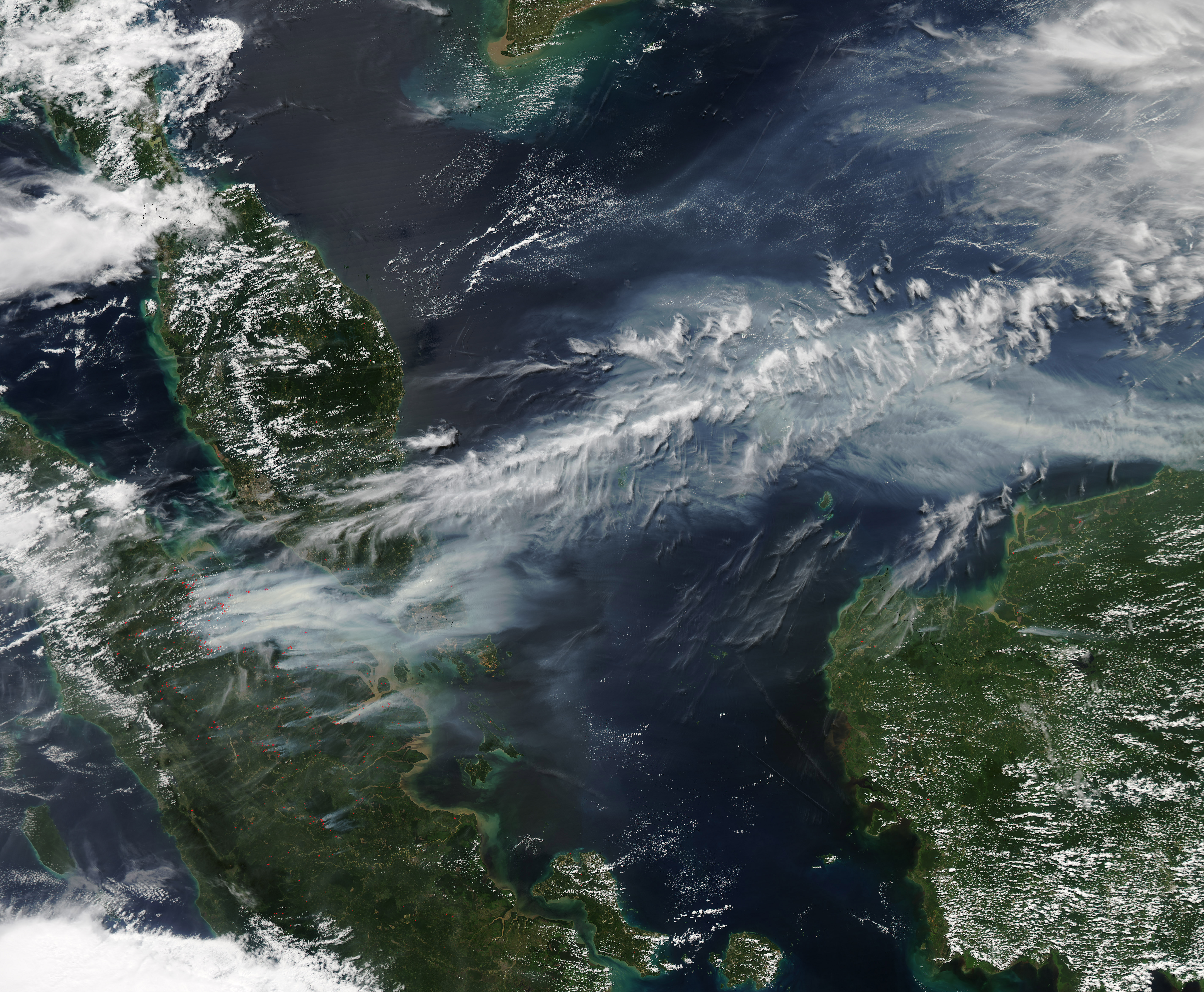
The Strait of Malacca separates Sumatra from the western coast of Peninsular Malaysia. Across this waterway, wind transports air and suspended particles without regard to national boundaries. An Indonesian fire plume can pass over sea lanes and reach Malaysian coastal communities when the weather aligns.
Sea water is a geographical boundary for travel and land management, not a wall in the atmosphere. Smoke can cross the strait, spread towards inland areas or move elsewhere depending on wind direction, its height and rainfall. Therefore a coastal town is not automatically cleaner simply because its residents face open water.
A historical NASA June 2013 satellite image of smoke crossing the strait provides a concrete geographical illustration. The featured image is dated and should never be used as this evening’s forecast.
The different coastal regions of Malaysia
Malaysia’s coastline is extensive and varied. West-coast Peninsular locations such as Penang, Perak, Selangor, Melaka and Johor face parts of the Strait of Malacca and related waterways. The east-coast states of Kelantan, Terengganu and Pahang face the South China Sea.
Sarawak’s coastline and Sabah’s multiple coastal exposures lie on Borneo, close to different regional fire-source geography. Labuan has its own offshore setting. Smoke reaching a port on western Peninsular Malaysia need not have followed the same pathway as smoke reaching a Sarawak river mouth.
One ‘Malaysia coastal haze’ map is therefore useful only as a national overview. A fishery, beach or passenger ferry needs information relevant to its actual place and time.
Air pollution at sea is not identical to marine water pollution
The smoke people see and inhale is suspended in the atmosphere. Some particles eventually deposit on the ocean surface, but this does not mean that every airborne aerosol automatically becomes a dangerous seafood contamination event. Particle chemistry, deposition rates, water mixing, biological uptake and local currents all matter.
Researchers distinguish atmospheric concentration, deposition flux, seawater chemistry and biological response. These are not interchangeable measurements. The Malaysian API is primarily designed to communicate ambient air quality and cannot directly diagnose fish health or seawater toxicity.
A 2022 scientific review indexed by NASA discusses atmospheric aerosols as sources of nutrients to ocean systems. It describes varied responses and why context matters, rather than declaring that every wildfire plume kills marine life.
Can smoke bring nutrients into the sea?
Yes, some atmospheric particles contain materials including iron or other nutrients. Depending on their composition and solubility, deposition can add nutrients to marine waters. Phytoplankton, which form the base of many food webs, need nutrients and sunlight to grow.
But nutrient input can have different effects in nutrient-limited versus already enriched or stressed ecosystems. A deposit that changes conditions in one part of the ocean may have little measurable effect elsewhere. Different smoke components and ocean currents complicate the response.
A general research finding about nutrient-bearing aerosols is not proof that a specific Malaysian fishery became more productive after a haze episode. Actual marine monitoring is needed.
Can haze harm marine ecosystems indirectly?
It is possible for smoke-derived material to interact with coastal ecosystems, but the mechanism and actual magnitude must be demonstrated rather than presumed. Many coastal stresses—polluted runoff, habitat loss, overfishing, heat, low oxygen, sediment and local discharges—can affect marine life separately from haze.
Fire damage to adjacent mangroves or coastal vegetation could also have consequences, but that is a direct fire or landscape impact, not the same thing as airborne smoke over the sea.
An accurate environmental article names the suspected pathway, identifies the measurements needed and does not manufacture a link between one smoky sky photograph and a fish mortality event.
A fisher at sea: why visibility matters
When haze reduces the distance at which obstacles and other vessels are visible, navigation may become more difficult. Weather, rain, darkness and sea state can also limit visibility. This is particularly relevant when a vessel is small, a route crosses busy waters or operations occur near a port.
The correct response depends on the captain’s competence, equipment, maritime rules and official notices. A public API category is not a navigation instruction, and no article should tell a fisher to depart because its author believes a certain number is acceptable.
Malaysia’s fisheries authorities emphasised caution about poor visibility in their dated October 2026 statements. That is a useful, proportionate message: do not automatically declare every fishery closed, but do not ignore a genuine safety condition.
What the Department of Fisheries said in October 2026
The Department of Fisheries statement reported on 11 October 2026 said there had been no reports of interruption to fishing activity, including operations at sea. Its senior official emphasised caution when visibility was reduced.
Three days later the LKIM statement of 14 October similarly described continuing fish supply and advised fishermen—particularly in areas of impaired visibility—to postpone trips where necessary for safety.
These statements should be read together. They do not say risk is zero, and they do not support an invented claim of a nationwide fish shortage. They record the situation as assessed by the authorities on those particular dates.
Why this is different from a fishing ban
A public-health air-quality warning and a legally binding fisheries or navigation restriction are different things. An operator might change plans for safety, a maritime authority might issue an operational notice, and a health agency might advise reducing outdoor exertion. They serve different purposes.
A report of poor visibility does not automatically mean the government closed every landing centre or banned all vessels. Conversely, the absence of a broad ban does not mean conditions on one particular route are safe for every boat.
Read the actual agency, date, location and instruction. The same principle applies to airports and schools: a category describes a condition; the responsible authority issues the operational direction.
Long fishing trips and inhalation exposure
Working aboard a vessel can involve hours in the open air, lifting gear, hauling nets, cleaning equipment and preparing a catch. Physical work raises breathing rates, potentially increasing inhaled smoke exposure when ambient pollution is elevated.
The relevant precautions depend on official Malaysian health advice, work arrangements, personal medical conditions and the vessel’s situation. Some tasks may be shifted or rescheduled, but fishing livelihoods often have little flexibility, making clear occupational guidance especially valuable.
People with established respiratory or heart conditions should follow their clinician’s advice. Severe or worsening symptoms require appropriate healthcare rather than reliance on a boat’s open-air location as protection.
Penang and Kedah: fish landing, north-western waters and haze
Penang and Kedah connect coastal communities, ports and fisheries with inland markets. A vessel leaving a northern jetty may encounter different weather and visibility from what a person observes in a city centre. Official local API is a useful exposure reference but does not describe sea state or navigational visibility along every route.
An October 2026 statement issued in Butterworth is relevant to northern fishers, but cannot be used to say what every vessel near Langkawi, Johor or Sabah experienced on the same day. Regional differences matter.
Families relying on fishing income may want timely announcements from the Department of Fisheries, LKIM and relevant marine authorities, rather than rumours that all fish supply has stopped.
Port Klang, Melaka and the busy Strait of Malacca
West-coast Malaysian waters include busy shipping corridors as well as smaller fishing operations. Around Port Klang, commercial logistics and coastal livelihoods share a wider maritime environment. Smoke may influence visibility and workers’ outdoor exposure, although actual operational disruption requires case-specific evidence.
Traffic density, ship emissions, port industry and regional fire smoke can also influence nearby air quality, making source attribution complex. A plume that appears in satellite imagery cannot identify the exact contribution of one vessel, industry or distant fire without further analysis.
Coastal residents should monitor their relevant official station and the status of activities they actually need to undertake. A port remaining operational is not a guarantee that every recreational or small-boat trip is advisable.
Johor’s coastal communities and the Singapore connection
Johor’s coastline faces several straits and seas near Singapore and the southern end of the peninsula. Maritime weather can differ from conditions several kilometres inland. A haze plume reaching Pasir Gudang may be influenced by regional transport and local emissions, while a family in another district can have a different measured API.
For commuters or travellers crossing into Singapore, note that Malaysia publishes API/IPU and Singapore publishes PSI and other air-quality values using its own methods. They should not be directly equated just because numbers look similar.
The Johor and Melaka haze guide handles cross-border commuting and family routines in greater detail.
The east coast: Terengganu, Kelantan and Pahang
Kelantan, Terengganu and Pahang face the South China Sea and have seasonal weather patterns that differ in important ways from west-coast areas. The Northeast Monsoon can bring significant rain and rougher maritime conditions in relevant periods. Such weather may dominate decisions even when the API is relatively low.
Smoke from regional fires could reach some east-coast districts under suitable transport, but no coastal state is permanently immune or permanently smoky. The practical decision must consider the actual current environmental and marine advisories.
Do not mistake a monsoon rough-sea warning for a haze warning. Both can affect fishing or tourism, but they have different mechanisms, agencies and safety implications.
Sarawak, Sabah and Labuan: another Borneo pathway
East Malaysia lies on Borneo and adjacent waters. Kalimantan fire activity can contribute to regional haze under suitable winds, while Sarawak and Sabah also have diverse local conditions. A plume over Kuching should not automatically be treated as identical to conditions off Kota Kinabalu or Tawau.
Fishing communities on different sides of Borneo may encounter different air masses and marine weather. Local official air-quality and operator or authority information is therefore essential.
The Sarawak and Sabah haze article explains the island’s state-specific exposure.
Sea breeze: why the coast is not always an escape from haze
A sea breeze is a near-surface circulation associated with heating differences between land and water. Depending on the background wind, it may bring cleaner marine air inland or transport particles from a smoke-affected air mass towards the coast.
The idea that ‘salt air washes away smoke’ is not a reliable air-quality principle. Humidity near the coast can also change aerosol light scattering, making the horizon appear different without proving a lower concentration.
Use the local API and meteorological explanation together. The presence of a beach or sea view is not evidence that the inhaled air contains no fine particles.
Fish markets, processing work and indoor air
A fishing economy extends beyond vessels. Unloading, sorting, icing, processing, distribution and market sales involve people working indoors, outdoors or in partly open facilities. Their environmental exposures may differ from a person at sea.
An open-sided market can receive outdoor smoke even when a roof offers shade. A cold store may have distinct ventilation and occupational issues. Those details explain why a general instruction to ‘stay indoors’ is insufficient for many livelihoods.
Employers and operators should follow relevant Malaysian occupational and health guidance, keep communications clear and avoid presenting one protective device as a solution to every airborne hazard.
Does haze automatically cause fish-price inflation?
No. Fish prices reflect catch volumes, species, season, fuel, weather, landing schedules, demand, storage, imports and many other factors. Haze could contribute to disrupted operations under some circumstances, but a higher API does not itself prove a fall in catch or a future shortage.
The October 2026 fisheries authority reports specifically cautioned about visibility while stating that general activities and fish supply had not been affected at the time. A headline claiming that all Malaysian fish became scarce would contradict that dated official information.
For an economic study, use actual landing volumes, fish-price records and transport information. Keep weather and haze influences separately labelled.
Marine tourism and coastal recreation are different from commercial fishing
Boating, island visits, beach running and marine tourism involve visitors with different expectations and tolerance for disruption. Some activities involve long outdoor exposure; others are relatively short transfers between managed indoor spaces. Venue and operator status must be checked directly.
A poor-air day is not proof that every island resort closes. Conversely, a tour running normally is not a personal medical clearance for a visitor with asthma or heart disease. Current local air quality, weather, marine conditions and individual health remain relevant.
The Malaysia tourism and haze guide addresses itineraries, attractions and the distinction between a national headline and destination-specific decisions.
What would prove that marine ecology was affected?
Suppose scientists suspect deposition from a smoke plume altered a coastal ecosystem. They would need samples of air and deposition, seawater chemistry, phytoplankton or other organisms, and appropriate comparison periods or sites. Rain, currents, runoff and existing pollution would also need consideration.
The cause-and-effect chain is not immediate. A measured rise in airborne particles above water is not the same as a verified change in fish reproduction or a toxic level in seafood. Strong marine research establishes each link in the proposed pathway.
Public writing should avoid claiming that a specific Borneo or Penang fish population has been damaged solely because a NASA image shows haze over nearby water.
Worked example: fishing operations versus supposed national supply
Hypothetical village dataset, not a real 2026 report: A harbour schedules 40 small-boat trips. On one morning, four operators postpone for visibility and 36 depart. The proportion postponed is 4 ÷ 40 × 100 = 10%.
That result describes scheduled departures at one harbour. It does not prove a 10% reduction in Malaysia’s fish supply, nor a 10% reduction in catch, because trip duration, catch, other harbours and stored inventory are unknown.
If the harbour resumed activities later, some postponement might not change weekly catch at all. This example shows why reporters should distinguish an operational precaution from a quantified national economic loss.
Worked example: separating measurements above and below water
Teaching scenario: A monitoring station reports Malaysia API 135, while a marine scientist separately measures a seawater nutrient concentration. Can the scientist use 135 as the nutrient concentration? No. API is an index constructed from air-pollutant observations; seawater measurements have their own units and sampling method.
A satellite aerosol product can suggest airborne material over the water, but deposition flux and ecological response remain further questions. Each instrument sits at one point in the scientific chain.
This is an excellent school activity: place ‘fire detection’, ‘wind’, ‘air PM’, ‘deposition’, ‘water chemistry’ and ‘fish abundance’ into separate boxes and ask which links are supported by observations.
A one-page decision routine for fishing households
First, identify the actual coastal location and check the latest official Malaysian air-quality observation. Second, obtain the relevant marine weather and navigational notices from responsible authorities. Third, review whether visibility, crew health and the specific vessel and trip require a change.
Fourth, communicate any real cancellation or delay to buyers, crew and family. Fifth, do not infer a market shortage or a toxic seafood problem without evidence. This routine connects safety with livelihood information in a way that is more useful than a dramatic photograph.
Emergency or occupational decisions belong to the properly trained crew and the relevant authorities. An editorial guide can explain the questions but cannot inspect a particular vessel or authorise departure.
Coastal haze as a geography and science lesson
Geography students can label Sumatra, the Strait of Malacca, Port Klang, Johor, Penang, the South China Sea, Sarawak and Sabah. They then use historical imagery and winds to explain how smoke crosses open water. Science students can distinguish aerosol transport from wet deposition and marine food-web response.
Mathematics students can analyse trip data without treating a percentage of postponed departures as a percentage of national fish output. Economics students can investigate fishermen’s income, transport schedules and market prices, keeping actual observations separate from speculative changes.
The broader eduKate air-quality monitoring literacy article provides a useful evidence framework.
Frequently asked questions about Malaysian coastal haze
Did haze stop all Malaysian fishing in October 2026?
No. Fisheries authorities reported no general disruption on 11 and 14 October, while warning about impaired visibility in affected areas. Conditions and notices may change later.
Is the Strait of Malacca a barrier to smoke?
No. Air and fine particles cross water when regional winds carry them.
Does a sea breeze guarantee clean air?
No. Its effect depends on the direction and composition of the air being transported.
Can haze harm fish directly?
Specific biological impacts require scientific measurements. Airborne smoke alone does not establish a fish die-off or contamination event.
Do aerosols sometimes supply nutrients to seawater?
Yes. Scientific studies examine nutrient deposition and complex ecosystem responses, but effects vary by location and pollutant mixture.
Should I avoid seafood from Malaysia during every haze episode?
There is no general basis to declare all seafood unsafe solely because haze is present. Follow specific Malaysian food-safety notices when applicable.
Does an API number determine whether a boat may depart?
No. Maritime operations require relevant visibility, weather, navigation and operator safety decisions.
Are fishing workers affected by polluted air?
They may be exposed during prolonged outdoor work; their precautions depend on current health guidance and individual circumstances.
Will fish prices necessarily increase?
No. Prices and availability depend on actual catches, demand, logistics and other conditions.
Where can fishers find current official information?
Use Malaysia APIMS for local air quality, and fisheries, marine and meteorological authorities for operational notices.
Connected reading across the eduKate haze ecosystem
- [eduKate: How Singapore Connects through Haze](https://edukatesg.com/portfolio/how-singapore-connects-psi-haze-air-quality-monitoring/
Official sources and editorial boundaries
Editorial checkpoint: 17 October 2026. The fisheries statements are dated 11 and 14 October and may not reflect later conditions. This is not a current vessel safety clearance, seafood contamination bulletin or verified estimate of fisheries losses. Featured NASA imagery is historical (19 June 2013).