
How do firefighters stop peat fires that cause haze in Malaysia?
A peat fire is difficult to extinguish because burning can continue below the surface of dried organic soil. Responders must first verify a real incident, protect people, understand where fire and smoke are moving, and use properly trained teams and site-specific suppression and water-management methods. Long-term prevention is equally important: restoring suitable peatland wetness and avoiding new ignition reduce the chance of the problem returning.
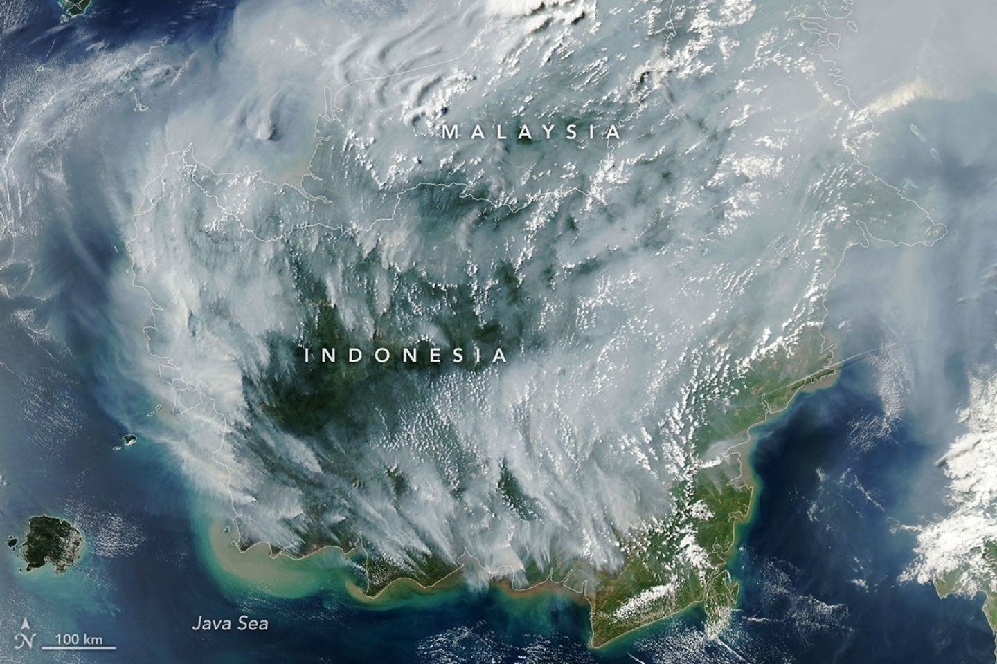
Malaysia’s haze can involve smoke from Sumatra and Kalimantan as well as local fires. When the source is overseas, Malaysian authorities can protect residents, monitor air quality and coordinate regionally, but they do not automatically control another country’s fire crews. The ASEAN Guidelines on Peatland Fire Management and NASA’s September 2026 satellite report explain the challenge. For real exposure, consult Malaysia APIMS.
This guide covers the whole response chain—detection, field verification, people, equipment, difficult terrain, peat hydrology, monitoring and recovery. It is not a tactical instruction manual for entering a fire zone or operating suppression machinery.
The peat-fire response in one minute
- Detect: Review satellite hotspots, ground observations and fire-danger conditions; a red dot is a possible fire, not full confirmation.
- Verify: Trained personnel assess the actual location, fuel and hazards before committing to a response.
- Protect: People, evacuation routes, crew breathing and access are immediate concerns.
- Respond: The competent incident team selects appropriate suppression resources and safe operating methods.
- Manage water: A deep organic fire depends on local soil moisture; water availability and hydrology affect the work.
- Check beneath the surface: Visible flames disappearing may not mean smouldering has ended.
- Document: Record verified incidents, affected area, conditions, response times and uncertainties.
- Restore: Reduce conditions that made peat dry and vulnerable in the first place.
- Coordinate: Share observations and assistance through the appropriate Malaysian and ASEAN institutions.
Why peat is different from burning grass
Grass and surface litter burn principally above ground, where flames may be visible. Tropical peat contains partially decomposed organic matter accumulated in wet conditions over long periods. When drained and dried, it can ignite and smoulder within the soil itself.
Subsurface burning may consume material in pockets with restricted oxygen. A surface that looks darker and relatively calm may still conceal hot or unstable areas. Responders must therefore follow professional site controls rather than assume a fire is out because the highest flames have disappeared.
The NASA Borneo fire observation explains why difficult-to-detect smouldering sources can create persistent smoke. It illustrates the mechanism; the particular incident still needs on-site assessment.
Why the source region matters to Malaysian communities
Sumatra faces Peninsular Malaysia across the Strait of Malacca. Kalimantan shares Borneo with Sarawak and Sabah. Smoke moving from either source can affect Malaysian areas under suitable winds, but it may not blanket the whole country equally.
A local crew in Johor and a response team in western Sarawak confront different terrain, water supplies, legal jurisdictions and risk exposures. A national headline should not erase those differences.
The Malaysia geography guide explains the routes that connect distant fires to local API stations. The path of smoke is a scientific question; operational authority remains tied to the relevant jurisdictions.

Satellite alerts: useful clues with known gaps
Fire-detection satellites identify thermal anomalies, commonly described as hotspots. Repeated detections and visible smoke can reveal possible active burning, helping agencies decide where to investigate. But cloud, smoke and satellite viewing schedules can obscure some sources.
A peat fire that smoulders beneath a surface layer may not look like a bright flame to an instrument in orbit. Fewer reported detections therefore do not automatically prove that all burning stopped.
Use dated ASMC fire and haze observations as one line of evidence, then verify according to the responsible authority’s procedures. A hotspot is not proof of a criminal act or a reliable estimate of every square metre burning.
Ground verification is a safety decision, not a sightseeing activity
A field visit can help establish whether there is real burning, its approximate extent, access limitations and risks to people and property. This work belongs to trained and appropriately equipped personnel. Unstable soil, heat, poor visibility and smoke can create danger even where the site appears quiet.
Members of the public should not enter a peatland fire or attempt to retrieve dramatic photographs for a social-media report. If a suspected fire is local, contact the appropriate authority using an official reporting route.
Scientific curiosity is valuable, but safe distance, lawful access and professional incident procedures are essential.
What makes water supply so important?
Deep peat fire and dry ground create a challenge that cannot be reduced to extinguishing a pile of leaves. Responders may require sustained access to suitable water resources and an understanding of how moisture moves through the affected landscape.
The availability of water is affected by rainfall, drainage, canals, local hydrology and environmental safeguards. Poorly considered interventions can cause other problems such as erosion, flooding or damage to nearby settlements.
Water-management decisions belong to qualified responders, land managers and hydrological professionals. The public should not attempt improvised canal changes or introduce machinery into unstable peat.
What rewetting means—and what it does not mean
Rewetting is the effort to restore or maintain suitable wet conditions in peat-rich landscapes. Where peat has been drained, improved water management may reduce future fire vulnerability and ongoing carbon loss.
That is usually a landscape-management task, not a promise that one rain shower will extinguish every subsurface fire. Ecological restoration can require engineered changes, landholder cooperation, monitoring and maintenance over years.
The ASEAN Peatland Management Strategy 2023–2030 gives the wider policy context. Prevention and emergency suppression are different parts of one system.
Can helicopters or aircraft end the haze?
Aerial observation and assistance can be valuable in some fire operations, particularly for mapping and access. But a dramatic photograph of aircraft dropping water does not demonstrate that deep peat combustion has ended.
Effectiveness depends on weather, terrain, water availability, safety and the actual fire. Some operations need sustained ground work and later verification. Public reporting should distinguish a deployed resource from a measured suppression outcome.
Do not turn an agency’s announcement that equipment has arrived into a claim that all regional fires have stopped. Successful response must be confirmed.
How smoke complicates work for firefighters
Smoke can obstruct visibility, impair navigation and expose responders to a mixture of fine particles and gases. Heat, fatigue, physical exertion and difficult ground increase the complexity of safe operations.
Firefighters use professional occupational procedures and equipment according to hazard assessment. A consumer face mask is not an adequate universal substitute for specialist respiratory protection, and no editorial article can specify a safe entry duration for a real fire zone.
The human dimension matters: protecting crews prevents the emergency response itself from becoming another source of injury.
Why the first hour and the first week are different challenges
An early detected ignition may present opportunities to respond before the affected landscape expands. A deeply established peat fire may need longer, sustained operations, as well as checks for smouldering outside the initially observed area.
The timeline is not always linear: wind, drying, rainfall and continued emissions may change the situation after a period of apparent improvement. Authorities refresh their assessments as evidence changes.
An effective response plan identifies who receives alerts, who verifies incidents, who has command, how other agencies assist and how progress is documented.
A local Malaysian fire and a foreign source require different authority
Malaysia’s Department of Environment, firefighters and relevant land or disaster authorities can have responsibilities within Malaysia. When important smoke sources occur in another country, coordination takes place within the applicable cross-border agreements and national systems.
The ASEAN haze agreement provides a framework for national prevention and regional information-sharing. It is not a blanket authority for Malaysian crews to enter another country without the relevant permission.
The legal accountability guide distinguishes a public-health alert from a finding of responsibility for a specific ignition.
When a fire is hard to see, how do responders know progress is real?
Incident teams can compare observations over time and use appropriate field verification to assess whether conditions are improving. Measurements of fire activity, affected area, residual heat or local hydrology may help under competent management.
A reduction in visible smoke from one viewpoint is not complete proof of extinguishment. It may reflect changes in wind, cloud or the position of the observer.
Strong public communication says which observations were verified and what remains uncertain. That is more trustworthy than declaring victory based on one clear photograph.
The difference between a hotspot count and burned area
A hotspot represents a thermal observation at a particular time and location. Burned area is an estimate of the spatial extent affected by fire. Multiple hotspots can be detected within one burned area, and some burned areas may not be captured by a particular satellite pass.
The ASEAN burned-area mapping guideline explains why consistent methods help responders and governments compare events.
A headline that treats 1,000 hotspots as ‘1,000 hectares burned’ is using the wrong unit. Students and reporters should keep the measurement types separate.
Why fire response depends on local communities
People living and working in fire-prone landscapes may provide early information about access routes, water sources, land use and emerging risks. They may also face direct threats to homes, livelihoods and health.
Long-term prevention works best when it includes workable alternatives to harmful burning and respects community needs. Reporting residents as obstacles to enforcement without evidence can obscure the economic and land-management realities.
Regional strategies therefore include education, participation, responsible land stewardship and fair support, rather than only emergency equipment.
The importance of fire prevention before the dry season
Teams cannot be everywhere simultaneously. Early warning, water management, safe land-clearing practices and verified restrictions can reduce avoidable ignitions before response resources become overwhelmed.
Preparation can include professional mapping of risk landscapes, maintaining appropriate infrastructure, coordination plans and public reporting routes. None of these is a promise that weather will cooperate.
The Malaysia prevention guide connects the upstream interventions with practical peat restoration and ASEAN financing.
El Niño affects preparedness, not the identity of an arsonist
A climate pattern such as El Niño can influence drought probability in parts of maritime Southeast Asia. Prolonged dry conditions can increase vulnerability where vegetation or peat has been disturbed or drained.
That does not establish the ignition source of an individual fire, nor mean every Malaysian district will experience the same plume. Human land-use decisions, weather, fire and air movement are separate causal links.
The Malaysia causes article gives the scientific distinction between dry conditions and actual combustion.
How responders and meteorologists use different evidence
Emergency responders investigate the actual site and work to manage fire and hazards. Meteorologists study wind, rainfall and atmospheric conditions. Satellite analysts detect possible sources and observed plumes. Ground air-quality networks measure receiving-area pollution.
All these measurements are useful, but none should impersonate another. A forecast plume is not a confirmed field fire, and a confirmed fire does not tell you the exact API in a faraway classroom.
The forecasting guide explains how regional dispersion models and observed ground values support different decisions.
What should Malaysian families do while crews fight?
Families do not need to wait for an official count of extinguished fires before making exposure decisions. Check the relevant APIMS station and current Malaysian Ministry of Health or school guidance, then adapt outdoor activities to individual health and conditions.
A child with a respiratory care plan needs the appropriate clinical guidance. A worker’s outdoor tasks require suitable occupational assessment. A reported fire operation does not create a universal instruction for every family.
The Malaysia API guide and health and daily-life article provide the practical downstream layer.
What counts as success beyond extinguishing flames?
A single incident may be successfully controlled yet the region remain vulnerable next dry season. Long-term success therefore includes reduced verified fire recurrence, improved water management where appropriate, suitable land use and fewer harmful pollution episodes.
Measured outcomes should account for weather and detection differences. If a rainy year has fewer fires, governments still need to know whether prevention reduced underlying vulnerability.
Reliable programmes track several indicators without pretending one number captures every ecological and public-health benefit.
Worked science example: a site with hidden risk
Illustrative teaching case: A hypothetical peat area has no visible flames after surface firefighting. A later trained assessment finds evidence of remaining subsurface heat. Would it be correct to announce that the incident was over based only on the earlier photograph? No.
The later verification changes the evidence. An effective public report describes what was observed when and what follow-up response the responsible team performed.
This exercise teaches the difference between visible appearance and underlying conditions without telling students to enter or test a real burning area.
Worked mathematics: response timing, not guaranteed outcomes
Imaginary dataset: Four verified alerts took 30, 45, 60 and 105 minutes to receive an initial field assessment. Their simple mean was (30 + 45 + 60 + 105) ÷ 4 = 60 minutes.
This statistic describes the four reported assessment delays. It does not prove that a one-hour mean is an adequate safety standard, or calculate how much burning was prevented. Location, access, fire conditions and reporting methods would need further study.
Operational improvement begins with reliable definitions and records, not arbitrary averages treated as universal targets.
Worked evaluation: burned hectares and hotspots
Suppose a student is given a fictional report showing 300 satellite hotspot detections and an independently estimated 80 hectares of burned land. Can the student say there were 300 fires each occupying a hectare? No.
Hotspots are observations; burned area is a separate spatial estimate. To evaluate the response, the student should ask about satellite coverage, field verification, time intervals and the method used to produce the area figure.
The exercise builds quantitative literacy and helps prevent exaggerated environmental headlines.
Why peatland fire response matters for climate and ecosystems
Burning peat can release carbon stored in organic soil and damage habitat. A short-term smoke emergency therefore connects to longer-term land subsidence, hydrology, carbon and biodiversity concerns.
Not every damaged area responds to one uniform restoration method. Water levels, vegetation, local livelihoods and maintenance affect recovery.
The Malaysia peat carbon article and ASEAN management strategy provide the broader ecological context.
Five mistakes in reporting peat fire suppression
- Calling every satellite hotspot a confirmed fire and a legally identified culprit.
- Presenting a single water drop or a rainstorm as proof that deep peat combustion has ended.
- Quoting aircraft or crew deployments as though those numbers measure actual emissions reduced.
- Treating hotspots, burned hectares, carbon tonnes and public API values as interchangeable quantities.
- Forgetting residents, responders, ecosystems and long-term restoration after the sky clears.
Frequently asked questions about peat firefighting
### Why can peat continue burning underground? Dried organic peat can smoulder below the surface, where it is difficult to observe and manage without appropriate field assessment.
### Can rainfall help suppress a peat fire? Yes, sufficiently sustained wetting can help, but a short local shower does not automatically extinguish deep burning or fires in a distant region.
### Are satellite hotspots the same as verified fires? No. They are detections of unusual heat consistent with possible fire activity.
### Can a Malaysian firefighter directly operate in Indonesia? Cross-border operations require the relevant national and cooperative permissions and arrangements.
### Does a clear sky mean the source is extinguished? No. Weather and smoke transport can change while some fires continue.
### Is rewetting the same as emergency firefighting? No. Rewetting can be part of longer-term landscape restoration and risk reduction, requiring site-specific design.
### What is the difference between burned area and hotspot count? Area estimates the extent affected; hotspots are discrete thermal detections.
### Is it safe for a volunteer to inspect burning peat? No untrained person should approach an active fire or unstable peatland. Report suspected incidents through authorities.
### Can a fire response report prove zero future haze? No. Future weather and ignitions may change; sustained prevention and monitoring remain necessary.
### What should families check during a distant fire response? Use current local air-quality and relevant Malaysian public-health instructions, not deployment statistics.
Continue through eduKate’s Malaysia haze ecosystem
Sources and editorial boundaries
Editorial checkpoint: 18 October 2026. This is fire-science and incident-governance education, not an operational firefighting manual, site assessment or real-time announcement that a particular fire has been extinguished. The featured image is a NASA observation from 1 September 2026.