
The Kerguelen Islands are a remote French archipelago in the southern Indian Ocean, with hundreds of islets, a dramatic volcanic plateau, a great ice cap and wildlife-rich coasts. They are part of the French Southern and Antarctic Lands and the French Austral Lands and Seas World Heritage property. They are not open for ordinary unregulated travel, but their maps and scientific history make an excellent learning route.
Start with the geography of Grande Terre, follow the volcanic origins and glacier, then examine wildlife, science, historical voyages and protected-area rules. Each of ten lessons has an activity and answer check; afterwards there is a worked conversion, family session, bilingual vocabulary, FAQs and source links.
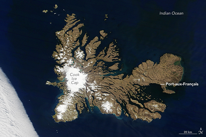
Featured satellite photograph: NASA Terra MODIS image of the Kerguelen Islands, 28 October 2016, NASA Earth Observatory, public domain. Cropped and labelled derivative via Wikimedia Commons. It is a historical geographic image, not a current navigation chart.

Choose a route: Quick facts · Ten lessons · Worked example · Family activity · Bilingual terms
Quick facts for readers
| Question | Starting answer |
|---|---|
| Where? | Subantarctic southern Indian Ocean, in France’s TAAF territory. |
| Land geography? | Grande Terre plus over 300 smaller islands; about 7,215 km². |
| Highest summit? | Mont Ross, approximately 1,850 m. |
| Major ice feature? | Cook Ice Cap in the western main island. |
| Station? | Port-aux-Français, permanent station established around 1950. |
| Protected status? | Part of French Austral Lands and Seas UNESCO property since 2019; national nature reserve since 2006. |
| Entry rules? | Strict limits, some closed zones, and location-specific permission requirements. |
Contents: ten things to learn
1. Find Grande Terre and more than 300 surrounding islands
2. Understand the volcanic Kerguelen–Heard Plateau
3. See how Mount Ross and the Cook Ice Cap share an island
4. Use the winds and ocean climate to interpret vegetation
5. Understand how seabirds and seals connect the island to the ocean
6. Discover Kerguelen cabbage and giant underwater kelp
7. Read the 1772, 1776 and 1893 history precisely
8. Meet Port-aux-Français as an operational research base
9. Understand why introduced animals and fisheries both matter
10. Read the UNESCO designation and real restrictions on access
Worked calculation · Family session · Vocabulary · FAQs · Sources · Keep learning
1. Find Grande Terre and more than 300 surrounding islands
The Kerguelen Islands form a large French subantarctic archipelago in the southern Indian Ocean. The French Southern and Antarctic Lands administration, known as TAAF identifies one main island, Grande Terre, surrounded by more than 300 smaller islands and islets, with a combined land area of about 7,215 square kilometres. This is much larger than the small low coral atolls studied elsewhere in the series.
Use a map of the southern Indian Ocean and then zoom into the winding coastlines. Grande Terre’s long peninsulas, fjords, bays and offshore islands make it difficult to measure distance by a straight line across water. A road map familiar from a city will not represent the island’s very different transport reality. Many sheltered bays are not public tourist harbours.
The 2016 NASA Terra satellite image used as the featured image shows Grande Terre and major geographical features. Its labels identify the Cook Ice Cap and Port-aux-Français, but it is still a dated remote-sensing record. It cannot show a safe present-day landing, every minor island or a visitor permit.
Try this: Draw a map of Grande Terre with two indentations in the coastline and explain why a simple oval would hide important geography.
Is Kerguelen one small, round island?
No. It is a large archipelago with a deeply indented main island and hundreds of nearby islets.
← Previous · Contents · Next →
2. Understand the volcanic Kerguelen–Heard Plateau
The TAAF geological overview describes the islands as the emergent part of the immense volcanic Kerguelen–Heard submarine plateau, with the archipelago beginning to emerge around forty million years ago. That time estimate relates to the geological history of the island group, not the age of every visible rock or the age of all individual landforms.
An underwater plateau is not a sunken continent drawn from imagination. Scientists study rock chemistry, dating, seabed structure and maps of the ocean floor to explain the origin of this unusually large volcanic feature. A map showing the modern shoreline alone cannot reconstruct all the plate and volcanic processes over millions of years.
Try two maps. On one, outline land currently above sea level; on the other, show the conceptual wider submarine plateau. Use different colours and a legend, then write what the evidence supports. The distinction is a powerful geography lesson: land that appears isolated can be part of a much larger geological system beneath the ocean.
Try this: Explain the difference between Kerguelen’s exposed islands and the broader submarine volcanic plateau.
Does an ocean-floor plateau mean the entire feature is dry land?
No. Most of it remains beneath the ocean surface.
← Previous · Contents · Next →
3. See how Mount Ross and the Cook Ice Cap share an island
The TAAF account identifies Mont Ross as the archipelago’s highest summit at about 1,850 metres and the Cook Ice Cap as a major feature of western Grande Terre. Snowy mountains, glaciers and lower coastal areas therefore coexist on the same island. The terrain is not uniformly covered by permanent ice.
The NASA Earth Observatory image and interpretation show part of the ice cap and the extremely complex coastal outline. A satellite image from October 2016 offers a historical snapshot. To assess whether a glacier is shrinking now, a researcher would need appropriately dated and comparable observations with defined glacier boundaries.
A glacier and a seasonal snow patch also require different labels. Snow can melt after a warmer period; a glacier is a persistent mass of land ice that moves over time. Write the observation date beside any claim about ice extent, and resist calling every white patch a glacier.
Try this: Annotate the 2016 satellite image with three features and one limitation of satellite observation.
Can one dated satellite image establish a current glacier retreat rate?
No. The rate needs suitable repeat measurements over defined periods.
← Previous · Contents · Next →
4. Use the winds and ocean climate to interpret vegetation
Kerguelen has a cool, wet and very windy oceanic climate. The official climate description reports an annual mean near 4.5°C in its profile and markedly different rainfall across the island. The western mountains and prevailing westerly winds help create contrasts between coastal areas, slopes and more sheltered settings.
This is not the same thing as saying that the islands are an ice-covered Antarctic desert. There are tundra-like landscapes, peat, lichens, scattered flowering plants and patches of vegetation. The lack of a warm summer limits growth, yet locally suitable moisture and shelter can still support plant communities.
An instructive diagram shows wind arriving from the west, rising over high land and crossing the island. Rather than mechanically predicting the rainfall at a specific station, students should identify what measurements would test the hypothesis: weather records, topographic data and observation sites on both sides of the landscape.
Try this: Make a conceptual wind-and-rainfall cross-section. Label it as a hypothesis to test with meteorological observations.
Is all of Kerguelen equally wet because it is one archipelago?
No. Terrain and winds produce important local contrasts.
← Previous · Contents · Next →
5. Understand how seabirds and seals connect the island to the ocean
The official wildlife account describes breeding colonies of king penguins, elephant seals, albatrosses and other seabirds along Kerguelen’s coasts. These animals need land for reproduction or rest but find much of their food offshore. The surrounding seas are therefore an integral part of the ecological story.
A dense penguin group photographed on land represents one moment of a life cycle, not a complete population estimate. Researchers distinguish breeding pairs, occupied nests and fledged chicks; seal studies may separate animals at a haul-out site from those feeding at sea. Each observation needs a date, location and method.
The physical environment explains some of the connections: ocean productivity supports prey, animals travel back to nesting areas and nutrients can move between coast and terrestrial habitats. Draw arrows for these processes, but do not invent tracking data for one specific bird or seal.
Try this: Draw a simple ocean-to-colony food web and label which organisms require land for breeding.
Do large breeding colonies mean all food is found on land?
No. Marine feeding grounds support many of the animals that breed ashore.
← Previous · Contents · Next →
6. Discover Kerguelen cabbage and giant underwater kelp
The TAAF natural history summary names Kerguelen cabbage, Pringlea antiscorbutica, as a characteristic plant. The island’s coastline also has extensive kelp communities, including giant kelp of the genus Macrocystis. One thrives on land; the other grows underwater. The word “plant” covers very different habitats and physiological challenges.
Kelp forests create three-dimensional habitat for marine organisms, while tundra plants contend with wind, low temperatures and demanding soils. A student should ask how each photosynthetic organism receives light and nutrients. A shoreline photograph may show kelp at the surface but cannot display the full structure beneath.
The historic name “cabbage” does not make the wild plant a recommended souvenir or a food source for visitors. Protection rules and biosecurity take priority. Study botanic descriptions, scientific photographs and authorised herbarium records rather than collecting specimens.
Try this: Compare the habitat requirements of Kerguelen cabbage and giant kelp in a two-column table.
Are kelp beds and terrestrial cabbage patches the same kind of ecosystem?
No. One is marine and the other terrestrial.
← Previous · Contents · Next →
7. Read the 1772, 1776 and 1893 history precisely
The TAAF history dates the recorded French expedition of Yves Joseph Kerguelen de Trémarec to 12 February 1772. James Cook reached the islands four years later. In 1893 the French vessel Eure formally took possession in the name of France. These events are not one undifferentiated “discovery”.
A dated ship record has its own perspective, while later maps and administrative decisions may change how a place is described. Precise words matter: “sighted”, “visited”, “mapped”, “claimed” and “administered” refer to different actions. Do not replace the chronology with a heroic legend or an unsupported claim that the islands immediately developed a resident town.
Later surveying by the Rallier du Baty brothers and work by Edgar Aubert de la Rüe and Andrée Aubert de la Rüe advanced geographic and geological knowledge. Their dated field seasons make a good timeline of scientific exploration, rather than just a list of famous names.
Try this: Build a short historical timeline and write exactly what occurred in 1772, 1776 and 1893.
Did Cook’s later visit and the 1893 formal French act happen at the same time?
No. They are separate events with different meanings.
← Previous · Contents · Next →
8. Meet Port-aux-Français as an operational research base
The TAAF station history explains that the French post-war missions led to the construction of the permanent station at Port-aux-Français, established around 1950. The base supports research, communications, logistics and the island district administration. A photograph of buildings should not be mistaken for a city centre with unrestricted accommodation.
Research facilities make many types of work possible. Scientists can record weather and atmospheric properties, study plants and wildlife, maintain long-term datasets and move supplies. The constraints of distance, weather, staffing and conservation mean that every activity needs careful planning.
For readers, an interesting way to interpret a station image is to identify the essentials of an isolated facility: shelter, communications, waste handling, food and fuel systems, and instrument sites. Treat the photograph as one dated snapshot and connect it to an official account rather than guessing how many people are there today.
Try this: Draw a station systems diagram with five functions and explain why research does not equal a civilian town.
Does a year-round research base mean there are ordinary hotels or public roads across the island?
No. This is a specialist remote station, not regular mass-tourism infrastructure.
← Previous · Contents · Next →
9. Understand why introduced animals and fisheries both matter
Human activities changed Kerguelen long before modern conservation designations. The TAAF ecological overview identifies earlier sealing and whaling exploitation and introduced species including rabbits, cats, rats, reindeer and trout. Not every introduction has the same effect. Some alter vegetation or prey on animals, while others change freshwater food webs.
Fishing for species such as Patagonian toothfish is another part of the surrounding region’s management context. Not all fishing is automatically permitted, and different zones have different rules. The word “protected” does not mean a uniform ban on every activity across all nearby ocean waters.
Researchers use monitoring to understand ecosystem change, while managers decide where fishing, science, or visitor access may be allowed. A causal diagram can connect an introduced herbivore to vegetation decline or an introduced predator to nesting success, but it should distinguish an observed impact from a hypothetical chain of events.
Try this: Choose one introduced species and draw a clear ecological impact chain. Mark which links are documented.
Does a marine-protected status necessarily create identical rules across all sea zones?
No. The management plan and zone definitions determine what is allowed.
← Previous · Contents · Next →
10. Read the UNESCO designation and real restrictions on access
The UNESCO World Heritage listing of French Austral Lands and Seas includes Kerguelen, Crozet, Saint-Paul, Amsterdam and nearby marine areas. The protection rests on exceptional biodiversity and ecosystem values, with the French Southern Lands national nature reserve established in 2006 and World Heritage inscription in 2019. Kerguelen is not being presented as an independent World Heritage nation.
The TAAF current access and anchoring guidance states that private-vessel anchoring and entry are highly limited and strictly supervised. Exceptional applications may be considered in specific circumstances, while certain strict-protection zones are closed. Travel ashore requires the district chief’s authorisation, and some sites need written authorisation from the territory administrator.
This is the practical conclusion: an attractive satellite image is not a visitor itinerary, and another person’s research permit has no bearing on your access. Students can learn from the island remotely by examining protected-zone rules, historic research and mapped habitats without claiming unrestricted personal exploration.
Try this: Write two statements: one on why the region is World Heritage and one on present-day access limitations.
Does a UNESCO listing grant the public an automatic right to visit?
No. Conservation status and access permissions are separate.
← Previous · Contents · Next →
Worked example: converting land area and understanding scale
Approximate input from the TAAF geography profile: Kerguelen’s archipelago has a land area of around 7,215 square kilometres. How many hectares would that represent? There are 100 hectares in 1 square kilometre.
Multiply 7,215 × 100 = 721,500 hectares. The two expressions describe the same approximate land area, simply using different units. Notice that the answer inherits the source’s approximation: writing 721,500 hectares does not make the measurement more precise than “about 7,215 km²”.
The UNESCO World Heritage property has a far larger reported area because it includes extensive marine zones and other French subantarctic islands. Do not substitute Kerguelen’s land area for the whole property, or treat the property-wide total as Kerguelen’s dry land.
Write the unit beside each comparison. A numerical answer that omits whether it refers to the island group, marine waters or an entire protected property is not a complete geography answer.
One-hour family learning plan
Start with fifteen minutes mapping the archipelago. Show Grande Terre, neighbouring islets and the broad Kerguelen–Heard Plateau. Mark the difference between exposed islands and the underwater feature.
Use another fifteen minutes to investigate geology and climate. Draw a conceptual fjord, Mont Ross and the Cook Ice Cap, then compare what the 2016 satellite image can show with what would require modern field measurement.
Next, spend fifteen minutes on the ecosystem: a king penguin or elephant seal’s connection between land and sea, followed by the effects of one introduced species. Use the official natural history account rather than making up colony counts.
Finish with the area conversion and one historical date, then read the access rules. Each learner produces a paragraph with a sourced fact, a calculation and an explicit uncertainty or restriction.
English–Simplified Chinese vocabulary
| English | 简体中文 | Meaning here |
|---|---|---|
| Archipelago | 群岛 | Group of islands. |
| Grande Terre | 大岛 | The principal island of the Kerguelen archipelago. |
| Submarine plateau | 海底高原 | Elevated broad feature beneath the sea. |
| Volcanic | 火山的 | Formed through volcanic geological processes. |
| Fjord | 峡湾 | Deep coastal inlet influenced by glacial processes. |
| Ice cap | 冰帽 | Mass of land ice covering high ground. |
| Westerly wind | 西风 | Wind blowing from west toward east. |
| Oceanic climate | 海洋性气候 | Climate strongly influenced by surrounding seas. |
| Kelp forest | 海藻林 | Dense underwater algae habitat. |
| Elephant seal | 象海豹 | Large seal that uses coasts to breed and moult. |
| Introduced species | 外来引入物种 | Organism brought outside its native range. |
| Research station | 科研站 | Facility supporting science and remote logistics. |
| Nature reserve | 自然保护区 | Protected geographical area with specified rules. |
| World Heritage | 世界遗产 | UNESCO recognition of outstanding universal value. |
Frequently asked questions
Where are the Kerguelen Islands?
In the southern Indian Ocean, forming part of the French Southern and Antarctic Lands.
Are Kerguelen an independent country?
No. They are administered as part of a French overseas territory.
How many islands form the archipelago?
TAAF describes Grande Terre and more than 300 smaller islands and islets.
Is the whole main island glaciated?
No. The Cook Ice Cap covers part of western Grande Terre, while other landscapes are ice-free.
How high is Mont Ross?
TAAF’s geographical overview gives about 1,850 metres.
Why are the islands geologically interesting?
They rise from the enormous volcanic Kerguelen–Heard submarine plateau.
Can penguins and seals be seen year-round?
Different species use the coast at different times. A specific date and population observation require evidence.
What is Port-aux-Français?
An operational research and administrative station, rather than an ordinary tourist city.
Does UNESCO status make visits automatic?
No. TAAF limits entry and anchoring, and some reserve zones are closed.
How can readers learn without travelling?
Combine maps, dated NASA images, TAAF science records and the UNESCO site description.
Primary sources and further reading
These sources describe physical geography, historical events, conservation values and present access arrangements. Keep the stated dates and administrative jurisdictions attached to each fact.
TAAF: Crozet, Kerguelen and other French subantarctic islands
TAAF: legally restricted access, landings and anchoring in the austral islands
UNESCO: French Austral Lands and Seas World Heritage property
TAAF: history of the Port-aux-Français station
TAAF: biodiversity observatory and national nature reserve
NASA Earth Observatory: Kerguelen Islands satellite interpretation
NASA Terra 2016 image, edited public-domain version on Wikimedia Commons
Keep learning in the southern Indian Ocean
French Southern and Antarctic Lands: parent learning guide
Heard Island and McDonald Islands