
Peter I Island is a remote ice-covered volcanic island off West Antarctica, with a Norwegian territorial claim and exceptionally difficult access. The Norwegian Polar Institute records its 1821 naming, the Norvegia expedition’s 1929 claim and the formal declaration in 1931. It is not an ordinary visitor destination; the practical journey in this article is through reliable maps, history, photographs and science.
These ten lessons show how to understand an unfamiliar polar place without inventing what its hidden ice, wildlife or current conditions must be like. Begin with location and volcanic geology, then follow historical events, international law and satellite evidence. Every lesson includes a task and answer check, followed by a worked mathematical example, family plan and bilingual vocabulary.
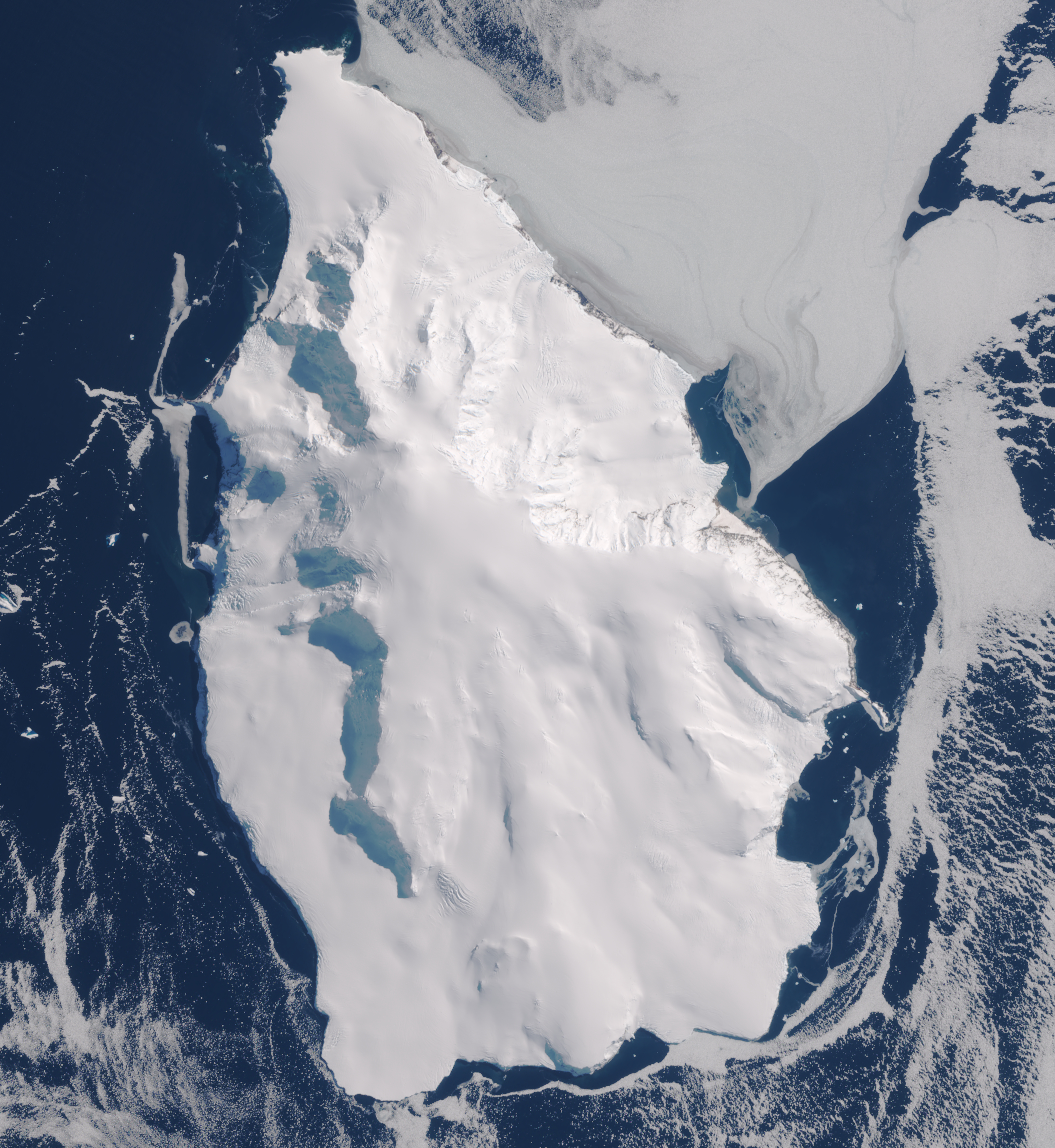
Featured satellite image: Peter I Island on 4 December 2022. Contains modified Copernicus Sentinel data 2023; Wikimedia Commons source and licence information. This is a dated observation, not a live access or navigation image.

Choose a route: Quick facts · Ten lessons · Worked example · Family activity · Bilingual vocabulary
Quick facts for your study
| Question | Source-based starting answer |
|---|---|
| Where? | Off West Antarctica, within the Antarctic Treaty area. |
| Landscape? | Volcanic island mostly covered by snow and ice. |
| Approximate area? | 156 km² in a Norwegian Polar Institute historical account. |
| Historical sighting? | 11 January 1821, attributed to Bellingshausen. |
| Norwegian claim? | Expedition claim in 1929 and dependency declaration in 1931. |
| Can ordinary readers plan a casual landing? | No. The island is exceptionally remote, and Antarctic rules and safety apply. |
Contents: ten things to learn
1. Locate an island more isolated than its name suggests
2. Read the shape of a volcanic island beneath its ice
3. Understand how cliffs and pack ice complicate access
4. Trace the 1821 naming event without inventing a landing
5. Examine the 1929 Norvegia expedition as evidence
6. Place the Norwegian claim within the Antarctic Treaty
7. Learn what a satellite image can and cannot reveal
8. Recognise limited wildlife records without inventing abundance
9. Calculate the difference between land area and visible rock
10. Choose research and stewardship over an invented itinerary
Worked example · Family plan · Vocabulary · Questions · Sources · Keep learning
1. Locate an island more isolated than its name suggests
Peter I Island, also called Peter I Øy, lies in the ocean off West Antarctica. The Norwegian Polar Institute’s educational history places it about 450 kilometres from the Antarctic mainland and describes its small size and difficult physical setting. Its name refers to an island, not a nation or a settlement that visitors can casually reach.
Start with a globe showing the Southern Ocean, then find West Antarctica, and finally use a detailed regional map. The difference in scale reveals why a small island can be important for polar geography yet practically inaccessible. A distance on the page does not account for storms, pack ice, sea conditions or authorisation.
At roughly 69 degrees south, the island lies within the Antarctic Treaty area. Geographic position therefore raises legal as well as scientific questions. A basic atlas can answer where Peter I Island is, while a current governmental source is needed to understand activities, responsibilities and rules for an expedition.
Try this: Write a two-sentence locator that includes Antarctica, the ocean and the separation from the mainland, then name one thing a map cannot prove.
Is Peter I Island an inhabited independent country?
No. It is an uninhabited remote Antarctic island associated with a Norwegian territorial claim.
← Previous · Contents · Next →
2. Read the shape of a volcanic island beneath its ice
The Norwegian Polar Institute describes Peter I Island as volcanic in origin, with a high summit associated with the former volcano. Much of the island is covered by ice and snow. Therefore the white shape seen from space conceals an underlying geological landscape, not a giant floating iceberg.
Draw a vertical cross-section: ocean at the edge, a rock foundation beneath, and ice above. Keep the drawing conceptual. Its shape cannot establish the thickness of the ice or the geometry of rock layers without measurements. Volcanic origin concerns the island’s geological formation, while present ice cover concerns climate, snow accumulation and glacier processes.
This makes a valuable comparison with Deception Island in the South Shetlands. Both have volcanic histories, yet they do not have the same shoreline, visible rock or visitor access. A single word such as ‘volcanic’ is not a substitute for studying an individual location.
Try this: Create a diagram with rock, ice and sea clearly distinguished. Label what is directly supported and what is conceptual.
Does seeing mostly snow from above mean the island is made entirely of snow?
No. Snow and ice cover a landmass of volcanic origin.
← Previous · Contents · Next →
3. Understand how cliffs and pack ice complicate access
The Norwegian Polar Institute’s historical account explains that steep coasts and surrounding pack ice have made landings exceptionally difficult. This is a historical physical description, not a checklist of safe landing sites today. The presence of an apparently open shoreline in one dated satellite image must never be treated as a safe route.
Wind, wave conditions, sea ice and the shape of a coast are separate factors. A boat may approach in open water and still have no safe or lawful landing opportunity. Emergency support can be extremely limited. Distance from shore, therefore, is not equivalent to practical reachability.
Use this as a geography exercise rather than an adventure challenge. Compare what a simple straight-line distance tells you with the operational details missing from it: ice, swell, weather, vessel capability and approvals. Conclude by explaining why a remote study is the appropriate default for families and casual readers.
Try this: On an imaginary map mark a straight line to the island, then list why it is not an actual route.
Does absence of visible sea ice in one image guarantee a safe landing?
No. It provides no assurance about present weather, sea state, coast hazards or permission.
← Previous · Contents · Next →
4. Trace the 1821 naming event without inventing a landing
The Norwegian Polar Institute’s history dates the sighting and naming of Peter I Island by Fabian von Bellingshausen to 11 January 1821. The ship and its crew did not land in that account. This creates an important distinction between sighting a place, charting it and setting foot on it.
Historical timelines become more reliable when their verbs are precise. ‘Observed’ does not mean ‘settled’; ‘named’ does not mean ‘administered’; ‘claimed’ does not mean ‘internationally undisputed’. Treat each action as a separate historical event requiring its own evidence.
The island was named after the Russian ruler Peter I. A name can preserve a navigator’s political and cultural context without indicating who lives there. Ask whose voyage produced the name, whose records survive and what the record cannot tell us about earlier knowledge or encounters. Uncertainty is part of careful history.
Try this: Write a timeline entry for 1821 using the verb ‘sighted’ or ‘named’, and a sentence explaining why ‘landed’ would be unsupported.
Was Bellingshausen’s 1821 sighting a documented landing?
No. The historical account describes a sighting and naming, not a landing.
← Previous · Contents · Next →
5. Examine the 1929 Norvegia expedition as evidence
The Norwegian Polar Institute records that the second Norvegia expedition claimed Peter I Island for Norway on 2 February 1929. The expedition was financed by Lars Christensen, and the Norwegian government formally declared the island a Norwegian dependency in 1931. These are dated political and expeditionary events, not proof of routine settlement.
The Institute’s account of the Norvegia voyages describes several Southern Ocean expeditions, including scientific surveying and political interests. Ships can serve both research and national policy. A history article should distinguish which purpose is explicitly documented, rather than assuming every crew member shared a single personal motive.
Build a source card for this expedition. Record the organisation, date, claim, supporting document and unanswered question. A photograph of an expedition team helps illustrate that particular moment, but does not automatically establish conditions for visitors a century later.
Try this: Make a two-date comparison: 1929 expedition claim and 1931 formal dependency declaration. Keep the verbs distinct.
Does a sovereignty declaration establish a permanent resident town?
No. Political status and human settlement are separate matters.
← Previous · Contents · Next →
6. Place the Norwegian claim within the Antarctic Treaty
Peter I Island is associated with Norway’s pre-Treaty claim, while the Antarctic Treaty provides the cooperative framework for activities south of 60°S. Article IV safeguards different positions regarding territorial claims without making Treaty-era activity a basis for new or enlarged claims.
This is a useful example of precise political writing. ‘Norway claims Peter I Island’ and ‘the Antarctic Treaty governs activity in the area’ address related but different questions. The Treaty supports peaceful uses and scientific cooperation, while leaving the parties’ sovereignty positions protected by the Article IV arrangement.
Avoid declaring that Antarctica is simply divided into fully uncontested national states, and avoid the opposite mistake of saying historic claims have magically disappeared. The right explanation keeps claim, Treaty responsibilities and operations separate. That is the same method used in careful accounts of other disputed or specially administered territories.
Try this: Write two short sentences: one on Norway’s historical claim and one on Article IV, with links to the relevant sources.
Does research on the island under the Treaty create a new sovereignty claim?
The Treaty does not allow Treaty-era activity to serve as a basis for new or enlarged claims.
← Previous · Contents · Next →
7. Learn what a satellite image can and cannot reveal
The featured Copernicus Sentinel-2 image depicts Peter I Island in natural-colour satellite data from 4 December 2022. It clearly helps identify extensive ice and the island’s outline. Its publication and processing details matter because a processed image is not a live webcam or a high-precision survey of every glacier crevasse.
Read the attribution carefully: the Commons file identifies modified Copernicus Sentinel data. Modification can improve contrast and readability, but an educational caption should retain the source and observation date. An eye-catching picture may include clouds, shadow and image-processing effects that complicate interpretation.
Ask three questions of every remote-sensing product: what sensor collected it, when was it collected, and which feature am I trying to identify? The image may help compare outlines across years only if the boundaries can be measured consistently and the conditions are appropriate. One image alone cannot establish the direction or rate of environmental change.
Try this: Annotate a copy of a satellite image with observation date, sensor, visible features and limits.
Is a 2022 satellite image a real-time map of landing conditions in 2026?
No. It is dated evidence about the time of observation.
← Previous · Contents · Next →
8. Recognise limited wildlife records without inventing abundance
The Norwegian Polar Institute’s historical description notes mosses, lichens, seabirds and marine mammals associated with Peter I Island and its waters. Because observations are relatively limited, a short description of species presence must not become an unsupported census of every population.
Different groups need different observation methods. A lichen growing on an exposed rock is studied differently from a seabird flying overhead or a seal moving through the water. A photograph of one seal establishes one visible occurrence, not the number living around the island year-round. The same restraint applies to species absence: failing to see an animal in a brief survey does not prove it never visits.
For learners, make a small classification table: land organisms, seabirds and marine mammals. Then name the evidence that could support each category. A list of organisms is a beginning; habitat relationships and the date of observations turn the list into a scientific explanation.
Try this: Create three species-category cards and a survey question for each. Leave population estimates blank unless supported.
Does a historical wildlife sighting supply a current population count?
No. Occurrence, population size and present condition are distinct claims.
← Previous · Contents · Next →
9. Calculate the difference between land area and visible rock
The Institute’s 2011 educational note gives the island’s area as about 156 square kilometres and describes it as almost entirely ice covered. That is a useful reminder that ‘land area’, ‘ice-covered surface’ and ‘ice-free rock’ are different measures.
For a deliberately simple practice example, imagine that 5% of an island’s 156 square kilometres is exposed. Compute 0.05 × 156 = 7.8 square kilometres of exposed area. The remaining 148.2 square kilometres in this simplified model is not necessarily the exact mapped glacier area because real boundaries, dates and classifications require scientific measurement.
This mathematical example is not a newly measured current ice-free area. A percentage from a dated historical profile should retain that date, while a claim about contemporary ice extent would need an appropriately recent dataset and a defined mapping method. Excellent environmental mathematics requires both correct arithmetic and correct evidence.
Try this: Explain in your own words why 7.8 square kilometres is a teaching calculation rather than a current surveyed value.
Does a correct percentage calculation prove that the input percentage was measured recently?
No. Arithmetic and the provenance of the data are separate.
← Previous · Contents · Next →
10. Choose research and stewardship over an invented itinerary
The Australian Antarctic Program explains the environmental assessment and authorisation obligations for Australian Antarctic tourism and non-government activities, while noting that other Antarctic Treaty nations authorise their own operators and citizens. These national processes, combined with Antarctic environmental rules, are central to any real proposal.
A highly remote island with steep coasts and difficult sea ice conditions is not an ordinary tourist location. A photograph on a travel website or a historical expedition account cannot certify that an operator is authorised, that a landing is planned, or that conditions make it safe. This guide does not provide a route or access promise.
For families, an entirely remote study is worthwhile. Compare a Norwegian exploration archive with the satellite image, build a geological model, and explain how Article IV works. The outcome is a sourced understanding of an unusual place without turning environmental risk into a challenge to be conquered.
Try this: Make a remote exhibit with a map, one expedition date, one geological explanation and a clearly dated satellite image.
Do historic landings mean an ordinary visitor may land today?
No. Past events do not replace current national authorisation, environmental controls and operational safety.
← Previous · Contents · Next →
Worked example: convert a percentage into an area carefully
Imaginary practice calculation grounded in the historical reported area, not a current scientific measurement: suppose a 156 km² island has 5% of its surface exposed rock. Estimate the exposed area.
First convert 5% to 0.05. Multiply 156 × 0.05 = 7.8 km². The complement is 156 − 7.8 = 148.2 km². In this simplified classroom model, 7.8 km² is exposed and 148.2 km² is not exposed.
But the arithmetic does not establish a live ice-cover survey. A coastline measurement, the definition of exposure and the observation date all matter. The figure 5% is drawn from a dated Norwegian Polar Institute outreach source. A present-day ice-free measurement would require appropriately recent mapped data.
Write a defensible conclusion: “Using a 156 km² area and an illustrative 5% exposed share, the calculated exposed area is 7.8 km². This does not establish the exact current mapped area.” Accurate calculations gain value when the reader can see what was assumed and what remains unmeasured.
Family or classroom plan: one hour of polar enquiry
During the first fifteen minutes, locate Peter I Island on a regional Antarctic map. Ask a learner to compare the straight-line separation from the mainland with what would still be needed to discuss any real voyage.
During the second fifteen minutes, draw a conceptual volcanic cross-section and place ice above the rock. The learner should state why a white satellite image does not mean the island is a floating block of snow.
In the third session, use the Norwegian historical records to build a three-point timeline: 1821 sighting, 1929 expedition claim and 1931 dependency declaration. Have someone explain the difference between naming, landing and making a political claim.
Finish with the worked area calculation and the dated Copernicus satellite image. Require one sourced statement and one evidence limitation. Add the Antarctic Treaty framework and explain why this research activity is more appropriate than promising an unauthorised landing.
English–Simplified Chinese vocabulary
| English | 简体中文 | Meaning in this guide |
|---|---|---|
| Dependency | 属地 | A territory in a dependent political relationship. |
| Antarctic Treaty | 南极条约 | Treaty establishing a framework for Antarctic activity. |
| Sovereignty claim | 主权主张 | Assertion of political authority over territory. |
| Volcanic origin | 火山成因 | Geological formation involving volcanic processes. |
| Ice cap | 冰帽 | Body of land ice covering a region. |
| Pack ice | 浮冰群 | Sea ice formed and transported in groups or fields. |
| Caldera | 破火山口 | Large volcanic depression. |
| Satellite imagery | 卫星影像 | Data collected by satellite instruments. |
| Remote sensing | 遥感 | Obtaining information without direct physical contact. |
| Observation date | 观测日期 | When evidence was actually recorded. |
| Moss | 苔藓 | Small non-vascular plant. |
| Lichen | 地衣 | Symbiotic organism often occurring on rocks. |
| Environmental assessment | 环境影响评估 | Assessment of an activity’s potential environmental effects. |
| Uncertainty | 不确定性 | Limits on what measurements or records establish. |
Frequently asked questions
Is Peter I Island an independent country?
No. It is an isolated Antarctic island with a Norwegian territorial claim and Antarctic Treaty obligations.
Can ordinary tourists book a standard trip there?
It is not an ordinary travel destination. Any proposed activity needs national authorisation and specialist operations; no landing is promised by this guide.
Is the island made from ice?
It is volcanic land that is heavily covered in ice.
When was it first sighted in the published history?
The Norwegian Polar Institute dates Bellingshausen’s sighting and naming to 11 January 1821.
When was Norway’s expeditionary claim made?
The second Norvegia expedition claimed the island on 2 February 1929, followed by a formal Norwegian dependency declaration in 1931.
Does the Antarctic Treaty cancel historic sovereignty claims?
Article IV preserves the parties’ positions and restricts using Treaty-era activity to assert new claims.
Why is it difficult to land?
The historical geological and climatic accounts describe steep coasts, pack ice, strong winds and isolated conditions.
What does the featured satellite image show?
A dated, processed Copernicus Sentinel view of the island’s surface and ice cover in December 2022.
How much of the island is ice-free now?
This guide makes no current measurement claim; that would require recent, defined mapping evidence.
What can a child learn from home?
Geography, volcanic landscapes, expedition history, Treaty governance, percentage calculations and source checking.
Sources and further reading
These sources distinguish expedition history, international obligations and current public learning resources. Do not convert historic observations into live access guarantees.
Norwegian Polar Institute: Peter I Øy official profile
Norwegian Polar Institute 2011: Peter I Island volcanic history and access
Norwegian Polar Institute: Norvegia expedition history
Norwegian Polar Institute: Antarctic Treaty and Article IV
Australian Antarctic Program: tourism and non-government environmental authorisations
Australian Antarctic Program: general Antarctic visitor guidance
Copernicus Sentinel Peter I Island 2022 satellite image and attribution
Keep learning about remote islands
Companion article: Top 10 Things to Do When Visiting and Touring Peter I Island
Bouvet Island: another Norwegian polar territory