
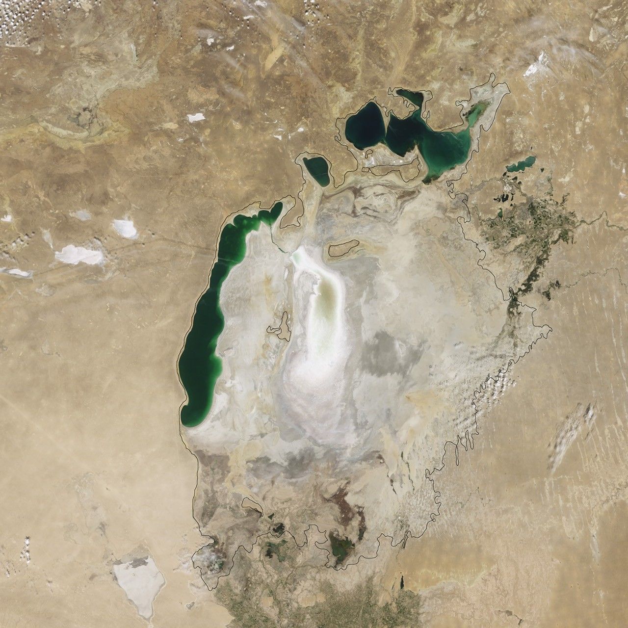
Did you know? A lake can lose most of its water without a single dramatic moment of collapse. For decades, the Aral Sea in Central Asia gradually retreated from towns that had depended on it. Fishing ports found themselves far from the shore, a former lakebed became a source of blowing dust, and decisions made far upstream transformed daily life downstream.
Before large-scale river diversion, the Aral Sea was one of the world’s largest inland lakes, often described as the fourth largest by area. Beginning in the Soviet era, water from the Amu Darya and Syr Darya rivers was redirected to irrigate crops, especially cotton and other farmland. The consequences accumulated across years, and the lake’s formerly connected waters separated into northern and southern bodies.
This is not a tale in which an entire civilisation vanished. It is a lesson in how a productive decision in one part of a system can destroy value elsewhere—and how targeted repair can sometimes restore part of what was lost. We will follow the evidence from NASA Earth Observatory, UN Environment Programme and the World Bank, then consider four conditional futures.
The Aral Sea in one minute: essential answers
| Question | Quick answer |
|---|---|
| Where is the Aral Sea? | Between present-day Kazakhstan and Uzbekistan in Central Asia. |
| Is it actually a sea? | Geographically, it is an inland lake without a direct outlet to the ocean. |
| Why did it shrink? | Large river diversions for irrigation reduced the water reaching the lake, alongside climatic variability and evaporation. |
| When did the main modern decline begin? | With large-scale Soviet-era irrigation diversions from the 1960s onward. |
| What happened to local people? | Fishing livelihoods, ecosystems, public health and settlement economies faced serious disruption. |
| Did the whole lake disappear? | No. Its basins changed differently; substantial portions of the South Aral shrank, while the North Aral partially recovered. |
| What happened in 2014? | NASA documented the temporary complete drying of the eastern lobe of the South Aral Sea. |
| What is the future lesson? | Water allocation must account for ecosystems and downstream communities, not only production upstream. |
First, imagine a shore where families had worked for generations
The Aral Sea once supported fishing communities, transport, wetlands and a distinctive regional environment. Ports and shoreline settlements had economic routines built around boats, fish processing, trade, maintenance and local services. A fisherman did not need to think about international river diversion each morning to know that the lake supported a livelihood.
The lake also formed part of an interconnected watershed. Rivers began far from the shoreline, taking water across territories before it reached the basin. Water used upstream could no longer be assumed available downstream. The ordinary act of directing river flow into a canal therefore had consequences that might only become fully visible after many growing seasons.
A great mistake in understanding civilisation is to look only at the location where a resource is used. A successful crop harvest can be economically valuable, but it may have hidden environmental costs at the other end of the water system. If no institution accounts for those costs, one region may prosper while another loses its economic foundation.
What changed in the 1960s?
The Soviet Union expanded large-scale irrigation in the dry Central Asian region. River water from the Amu Darya and Syr Darya was redirected to support cotton and other agriculture. Over time, far less water reached the Aral Sea. Evaporation and variable inflow contributed to its shrinking extent.
NASA’s World of Change imagery explains the central history and lets readers follow the changing shoreline through satellite observations. Its images from 2000 onward capture a lake that had already shrunk significantly from its 1960s outline.
One must not confuse the start of the irrigation policies with the dates of satellite images. A photograph made in 2009 documents conditions in 2009; it does not show what the shore looked like in 1960. Historical understanding combines records of policy with images from different points in the retreat.
Did you know? Water did not merely evaporate from an untouched lake
Arid climate and evaporation had always mattered to a landlocked lake. Yet the modern dramatic decline was not simply a story of natural dryness. The key change was the large reduction in river inflow caused by irrigation diversion, supplemented by weather and watershed variation.
When river water is distributed across extensive irrigated fields, some benefits appear immediately: crops grow in places that otherwise might support far less cultivation. The long-term cost is felt where the river no longer reaches its former destination. If the allocation ignores ecological needs, the lake slowly contracts.
This makes the Aral Sea a major warning about cross-boundary externalities: costs imposed on people or ecosystems outside the decision-maker’s immediate accounting. Those affected may have less political power than the groups receiving the immediate economic gains.
How does a shrinking lake damage a fishing economy?
A port works because vessels can reach the water, fish can be caught, and processing and distribution have buyers. As the shoreline retreats, vessels may become stranded and harbour facilities lose their original purpose. Rising salinity and changing habitat can further weaken fish populations and the associated food web.
NASA’s earlier account of the Aral Sea’s decline describes the fall of a once substantial commercial fishing industry as water conditions changed. More recent NASA summaries also emphasise the collapse of fisheries and local communities dependent on them.
The first loss is not just fish. It can extend to boat repair, refrigeration, markets, transport, seasonal work and the shops serving fishing households. This is a cascade through a local economic ecosystem. A large industry is rarely one job alone.
The new lakebed became a new environmental problem
When water retreats, it exposes sediments that had been underwater. In the Aral Sea region, the uncovered lakebed became part of a spreading dryland environment often called the Aralkum Desert. Winds can lift salt-bearing dust and, in some areas, material associated with past agricultural chemical contamination.
The World Bank’s account of Aralkum landscape restoration explains how exposed saline soils and chemical residues contribute to dust hazards, degrading air quality and affecting local livelihoods. The UN Environment Programme also describes efforts to stabilise the exposed seabed with vegetation.
It would be too simplistic to attribute every illness reported in the wider region solely to the lake’s retreat. Communities face multiple health influences, and establishing causation for individual conditions requires epidemiological evidence. The sound conclusion is that lake shrinkage created or worsened environmental exposures and serious public-health concerns.
What the satellite pictures actually prove
Satellite images offer compelling, measurable evidence of changes to water extent. They show where the lake surface appears in particular seasons and years. By comparing multiple images carefully, scientists can reconstruct a dramatic long-term pattern.
But they do not directly reveal what an individual family earned, how a water-allocation decision was negotiated or who fell ill. Those questions need records, field studies and community testimony. Image interpretation should also account for seasonal variation, differences in water level and the fact that a particular image is a snapshot.
NASA’s 2014 report described the eastern lobe of the South Aral Sea as completely dry for the first time in modern observational history. Yet NASA’s later imagery documented some water returning under different flow conditions. That is why readers should avoid the unsupported claim that a 2014 shoreline is permanently fixed.
One Aral Sea became several very different stories
As the lake withdrew, the northern and southern bodies followed different trajectories. The North Aral Sea lies mainly in Kazakhstan and receives water from the Syr Darya. The South Aral Sea, largely associated with Uzbekistan, depended especially on inflow from the Amu Darya, and its water coverage became highly variable and greatly reduced.
This geographic separation is not just a cartographic curiosity. It meant that management choices could support one basin differently from another. A single headline about “the Aral Sea” might conceal partial recovery in one place and ongoing ecological damage elsewhere.
The distinction is central to responsible civilisation analysis. If a region contains successes and failures at the same time, a single average can hide the people who still lack protection. We need a map of who benefits, who bears costs and which interventions are realistically available.
Did you know? The North Aral Sea partly recovered
Kazakhstan, with financing support from the World Bank, constructed the Kok-Aral Dam in 2005 to retain more water in the North Aral Sea. NASA’s North Aral Sea Recovery account reports that water levels rose appreciably after completion and that local economic activity, including fisheries, began to recover.
A US Geological Survey account of the North Aral Sea describes stabilised water levels, reduced salinity and the rebound of commercial fishing. The UNEP foresight brief treats this targeted effort as a significant example of partial ecological restoration.
There is an important qualification: success in the northern basin is not the same as restoring the entire lake to its historical extent. Keeping water in the North Aral can limit flow into the southern basin, and conditions in the different water bodies depend on multiple decisions and climatic conditions. A partial win is still valuable, but it should be described accurately.
The trade-off: who gets the river water?
Water can support cotton production, other crops, towns, hydropower where river systems permit, wetlands, fisheries and habitats. These uses are not identical. They operate on different seasonal schedules, produce different types of value and affect different communities.
Suppose an irrigated field produces export revenue, while the river’s downstream lake supports fishing, biodiversity and air-quality protection. If the accounting records only the crop revenue, decision-makers may see diversion as a success while the wider basin becomes poorer.
A trustworthy water-allocation plan has to name these competing benefits, measure flows and acknowledge who is affected. Cross-border river management adds further complexity because states and regions may have different priorities and institutions. Cooperation is not an ornamental ideal; it affects the physical outcome.
Why this is a civilisational story, not merely an environmental story
Civilisation includes the systems through which people organise water, food, income, health, public infrastructure and shared responsibility. In the Aral region, an environmental change altered communities’ economic structure and the conditions under which people could continue familiar occupations.
Some families adapted by changing work or moving. Others remained and faced new constraints. New environmental projects created different possibilities, but they did not erase decades of losses. The political and ecological questions crossed borders and outlasted the original planners.
It is important not to describe Central Asian peoples as passive victims whose history ends with an aerial photograph of an empty lakebed. They continue to build communities, research remedies and take part in decisions about land and water. A damaged ecosystem is not the extinction of a population or culture.
The chain of cause and effect
| Stage | What happened in the Aral case | Future question |
|---|---|---|
| Decision | Large volumes of river water were diverted for irrigation. | Are all users and downstream needs included in allocation? |
| Physical effect | River inflow into the lake was reduced. | Are water balances independently measured? |
| Ecological effect | Water level, salinity and habitats changed. | Are thresholds for ecological damage visible? |
| Economic effect | Fishing and related livelihoods contracted. | Who bears costs outside the primary project? |
| Secondary impact | Dry lakebed created new sources of salt and dust. | What additional hazards appear as a system changes? |
| Adaptation | Targeted northern recovery and dryland restoration began. | Which repairs are feasible, equitable and measurable? |
The difference between a project succeeding and a system succeeding
A canal may be judged successful because it reliably delivers water to farms. A farm may be judged successful because yields rise. Yet a watershed has a larger balance sheet, including downstream supply, ecosystem health and the economic base of towns far away from the canal.
This is a common systems problem. Local optimisation can create global loss: one component performs its assigned task while the connected whole deteriorates. The Aral Sea illustrates why good engineering needs basin-scale evidence and institutions empowered to address costs beyond a project’s fence line.
For future civilisation, the question is not whether development should ever alter a landscape. People need food and livelihoods. It is whether costs are recognised early enough, alternatives are assessed, and safeguards can prevent one region’s gain from becoming another region’s prolonged disaster.
What can restoration realistically achieve?
Restoration can reduce particular harms: retaining water in a feasible basin, rebuilding fish habitats, supporting different livelihoods or planting vegetation on exposed dust-producing land. Each intervention has its own required inputs, maintenance obligations and environmental conditions.
The World Bank’s 2024 discussion of landscape restoration in Uzbekistan describes work to stabilise degraded landscapes, including vegetation intended to reduce sand and dust storms. The UNEP overview of saxaul planting explains why hardy desert species are part of the response.
That work is not equivalent to refilling the entire historical Aral Sea. It attempts to reduce the cost of damage that has already happened. A mature resilience policy distinguishes prevention, mitigation, restoration and adaptation rather than calling them all the same thing.
What will happen to future civilisation? Four conditional scenarios
These are illustrative scenarios, not predictions of specific governments or regions. Future outcomes depend on water availability, crop choices, technology, institutions and the distribution of benefits and costs.
Scenario 1: basin-wide water accounting changes decisions early
A river basin establishes transparent measurement of water withdrawals, downstream flows and ecological conditions. Public reports show which uses are economically valuable and which are generating uncounted damage. Farmers gain access to water-efficient methods suited to their circumstances.
The lake or wetland does not necessarily recover instantly. The gain is that decision-makers can adjust allocations before a shrinking ecosystem reaches a costly threshold. Verification matters: advertised water savings must translate into actual downstream or ecological benefit.
Scenario 2: production rises while the downstream ecosystem deteriorates
Crop output and export earnings increase, but the river’s total withdrawals rise faster than any efficiency improvements save water. The downstream wetland contracts, air-quality hazards increase and fishing livelihoods fall. Public agencies respond only after local communities experience major losses.
Here the warning is rebound risk: making irrigation more efficient per hectare does not automatically reduce total abstraction if the cultivated area expands. The real indicator is what happens to total basin water use and ecological inflow.
Scenario 3: a targeted restoration succeeds but cannot repair everything
A community invests in a feasible partial restoration. Water levels stabilise in one part of a basin, selected fisheries recover and local employment improves. Other parts remain too dry or too altered for rapid recovery.
This pathway resembles the importance of the North Aral example without promising the same result everywhere. The policy question becomes how to support those who cannot benefit from the selected intervention and how to manage the redistribution of water fairly.
Scenario 4: dryland adaptation becomes essential
Suppose full lake restoration is not practicable under available flows. Communities focus on reducing wind erosion, protecting drinking-water systems, monitoring air quality, diversifying livelihoods and making healthcare accessible. Environmental restoration and adaptation proceed together.
A responsible government reports what cannot be restored as openly as what can. Hope remains grounded when projects have measurable goals, time horizons and independent checks—not when every announcement promises the return of an old shoreline.
A future-warning dashboard for river basins
Measure flows entering and leaving major irrigation systems, groundwater where relevant, crop water productivity, changes in lake area, salinity, ecological condition, exposed sediment and dust events. But add household indicators: employment, access to safe water, health-service capacity and the prospects of young workers.
One number cannot measure the wellbeing of a complex watershed. Water extent may rise in one basin while conditions decline in another; the fishery might recover while other sectors remain weak. Disaggregate by location and community, and publish the uncertainties.
The dashboard must also be connected to responsibility. If monitoring detects declining inflow, who has the legal authority to respond? Who can negotiate an adjustment? How quickly is a promised intervention assessed for actual effect? Data without institutions is observation without repair.
A five-minute thought experiment: two towns and one river
Town A uses river water to irrigate a profitable crop. Town B lies beside a lake downstream and relies on fishing and tourism. For ten years, Town A’s agricultural output rises while Town B’s shore retreats. Both communities claim their future depends on water.
Design a negotiation that does not simply demand one town surrender its livelihood. What water measurements are required? How would you price or recognise environmental harm? Could different crops, irrigation schedules, compensation, ecological flows or support for alternative work improve the outcome?
Now make the scenario more difficult: Town A and Town B are in different countries. The river begins in a third. Which institutions would be needed to make an agreement credible when each participant faces pressure to protect its own short-term interests?
Read the photograph carefully
The featured NASA image shows the Aral Sea in August 2009, not its complete history or present-day extent. It helps visualise the remnant water and broad areas of former lakebed. To study change properly, compare it with NASA’s multi-year satellite series and the separate North Aral recovery images.
Ask three questions. What can the camera measure? What has to be inferred from other records? And which human experiences cannot be seen from orbit? The method applies well beyond this particular lake.
A satellite photograph can reveal environmental change. It cannot alone tell us whether a water-sharing agreement was just, whether an individual worker found a job or how a family’s daily life felt. Responsible journalism, geography and history use different types of evidence together.
Comparing the Aral Sea with other historical transformations
At Ephesus, a changing coastal environment altered a city’s relationship with its harbour; the processes were different from a modern river-diversion project. In Mesopotamia, irrigation and soil salinity illustrate another way an agricultural system can accumulate costs.
The 1930s Dust Bowl offers a comparison in which degraded land and drought interacted with livelihoods and institutions. These cases should not be treated as identical events. They reveal a shared question: when a society depends on land or water, how does it protect the ecological system that makes production possible?
For the overarching framework, see Do Civilisations Collapse or Transform? and Civilisation: The Beginner’s Guide.
Frequently asked questions
Where is the Aral Sea located?
It lies between Kazakhstan and Uzbekistan in Central Asia, with a watershed extending beyond those two countries.
Why is it called a sea if it is a lake?
The historical name includes the word sea, but geographically it is a landlocked inland lake rather than part of the ocean.
What made the Aral Sea shrink?
Large-scale diversion of inflowing rivers for irrigation was the central driver of its modern retreat, alongside natural variation in river flow and evaporation.
Did cotton production cause everything that happened?
Cotton and other irrigated agriculture played a major role in water diversion, but a full explanation includes multiple land uses, governance choices, climate variability and different histories of the northern and southern basins.
Did the Aral Sea completely disappear?
No. The lake split into different water bodies. Some southern areas dried dramatically, while the northern basin experienced substantial partial recovery after targeted intervention.
What happened in 2014?
NASA documented the eastern lobe of the South Aral Sea fully dry for the first time in the modern observational record. Later water extent fluctuated, so that image should not be used as a permanent map.
What is the Kok-Aral Dam?
A barrier completed in 2005 that retains more water in the North Aral Sea, helping stabilise its levels and support the recovery of some fisheries.
Can planting trees refill the lake?
No. Vegetation on exposed lakebed aims to reduce dust and stabilise land. Refilling a lake requires sufficient inflow and water management; planting alone does not create that water.
Did the people and culture of the region disappear?
No. Communities continue to live, work and adapt in the region. The loss of a former ecosystem or a particular industry is not the disappearance of a population.
What is the biggest lesson for future civilisation?
A project should be judged by its effects on the whole connected system. Water, crops, ecosystems, health and livelihoods need long-term accounting, transparent trade-offs and institutions capable of changing decisions.
Continue exploring the Civilisation futures library
- When the Soil Blows Away: The Dust Bowl 1930s
- When Harbours Silt Up: Ephesus and the Changing Coast
- When Food Production Falls: Mesopotamia and Soil Salinity
- When Canal Networks Change: Ancestral Sonoran Desert
- Do Civilisations Collapse or Transform?
Sources and further reading
- NASA Earth Observatory — World of Change: Shrinking Aral Sea, original river-diversion history and multiyear satellite record.
- NASA Earth Observatory — Aral Sea Continues to Shrink (2009), source of the satellite cover image.
- NASA Earth Observatory — The Aral Sea Loses Its Eastern Lobe (2014), a specific dated observation, not a permanent forecast.
- NASA Earth Observatory — New Water in the Aral Sea, later seasonal variation and basin management.
- NASA Earth Observatory — North Aral Sea Recovery (2007), the effect of the Kok-Aral project.
- US Geological Survey — North Aral Sea, stabilisation and fisheries.
- UN Environment Programme — The Changing Aral Sea, 2017 foresight brief on decline and partial restoration.
- World Bank — Greening the Desert in Uzbekistan, 2024 account of exposed lakebed and landscape restoration.
- UNEP — Greening a Toxic Dryland, revegetation as risk reduction, not replacement for lake restoration.
Editorial review: 25 October 2026. The cover is a NASA Terra MODIS image acquired on 16 August 2009, not a present-day image. Descriptions of the South Aral’s retreat and the North Aral’s partial recovery are kept separate. Future scenarios are conditional rather than predictions.