
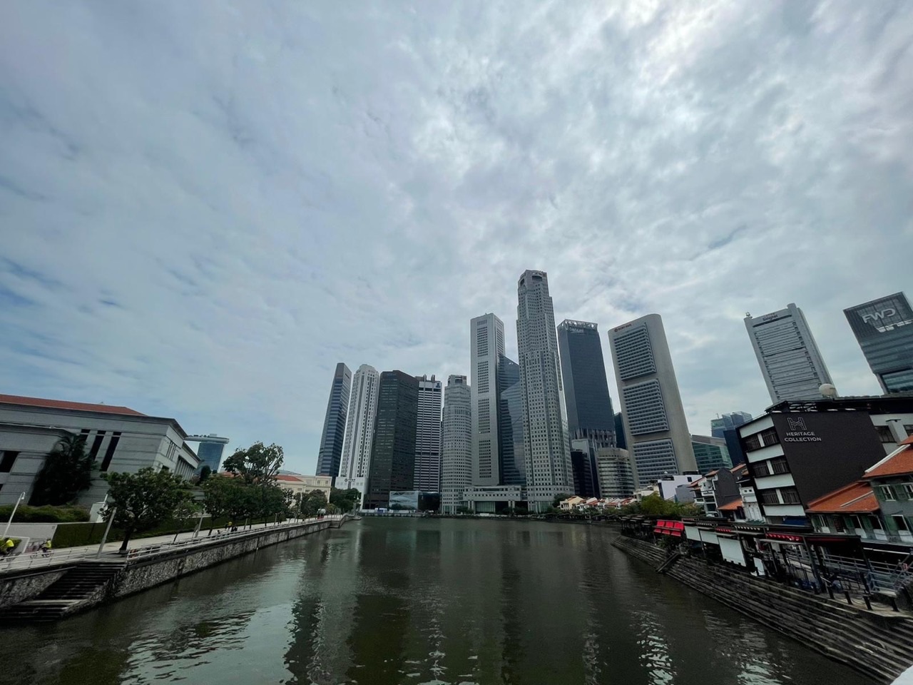
The Singapore River district is easiest to understand one address at a time. Ask when a place began, what changed around it and which parts survive. That approach reveals a more varied history than any single label, such as old waterfront or entertainment district, can capture.
This article covers the formal Singapore River planning area, organised around Boat Quay, Clarke Quay and Robertson Quay. SingStat’s planning-area and subzone tables identify these three separately under Singapore River. The physical watercourse, its wider catchment and the planning area are different things. The quays also have overlapping historical, commercial and conservation boundaries.
For a particular site, use URA’s Singapore River boundary-map service alongside its Master Plan 2025 zoning layer. A river-facing address does not automatically place a building inside this planning area. Fort Canning, the civic river mouth and neighbouring River Valley have their own histories; this page concentrates on the quay district and clearly connected sites rather than absorbing every landmark visible across the water.
The neighbouring History of Singapore | River Valley develops the broader story of labour, river trade, cleanup and residential change. Downtown Core follows the civic and commercial waterfront downstream. Here, the main question is more specific: what happened at these particular places, and why did their next use take the form it did?
1820: A Congregation Before the Modern Quays
Masjid Omar Kampong Melaka began in 1820, when the Arab merchant and philanthropist Syed Omar Aljunied established a timber-and-attap mosque. The National Heritage Board’s site account identifies it as Singapore’s oldest mosque. Its history belongs to people settling, worshipping and supporting a community near the river, not only to the movement of cargo.
As the congregation grew, Syed Omar’s son financed a larger brick building in 1855. Further redevelopment in 1981 added facilities and a minaret; work in 2009 included classrooms and a women’s prayer area. The surviving institution is older than much of its present fabric. That distinction matters: an establishment date describes the beginning of a community institution, while a building date describes a particular physical form.
The mosque now sits among much larger buildings off Havelock Road. Its continued presence gives the district a useful human scale. When passing a working place of worship, the first responsibility is respect for its congregation; a historical interest in a building does not make every room or ceremony a visitor attraction.
1823: Boat Quay Was Made, Not Simply Found
According to URA’s Boat Quay conservation history, earth from the levelling of a hillock at Battery Road in 1823 helped fill the swampy south bank and create Boat Quay. Commercial Square, later Raffles Place, emerged from the same operation. The riverfront and the commercial centre were therefore physically linked through earth-moving as well as trade.
The shoreline became more durable. From 1846, stone finished the river edges, with granite paving imported from Fujian. Much later, the promenade was raised by three steps during improvements in the late 1980s, while original nineteenth-century granite steps were retained. Look at the edge as a layered piece of engineering: the difference between levels records attempts to make the quay usable under changing conditions.
This small stretch of bank shows why a city’s oldest-looking spaces may contain alterations from several centuries. A retained step can be genuinely old even when the walkway beside it has been raised or resurfaced. The historical interest lies in how those parts fit together, rather than in assuming the whole view belongs to one date.
Kampong Melaka: A Neighbourhood Behind the Waterfront
The river’s communities extended into streets that a visitor can easily overlook. NHB’s Forgotten Histories research describes nineteenth-century Kampong Melaka as a mixed neighbourhood of Malay, Arab, Bugis, Chinese and Jawi Peranakan property owners. Abdullah bin Abdul Kadir lived there in the 1840s. Such details make the riverside more than a collection of trading firms: it was also an inhabited town with languages, households and meeting places.
The same research records six Chinese theatre halls in Kampong Melaka, three along the now-expunged Wayang Street. Cantonese opera was important there, with some venues also hosting other opera traditions. Performance had an address and a local audience long before the modern entertainment district. The disappearance of a street can remove an obvious way of remembering those activities, even when the wider neighbourhood remains busy.
This is why a present-day map cannot tell the entire social story. It shows where streets run now. An older street name, a theatre notice or a property record can reveal a gathering place that has vanished. In this district, the spaces behind the riverfront deserve attention as well as the photograph-friendly first row.
Ellenborough Market: Rebuilding, Fire and Another Beginning
Ellenborough Market was built in 1845 and became associated with the surrounding Teochew community. NLB’s history of Singapore’s wet markets describes its reputation for fresh fish and dried seafood. It stood between Ellenborough Street and Fish Street, names that no longer appear as ordinary streets in the modern district. Food buying brought a different daily rhythm from bulk cargo handling.
An archival postcard dated around 1910 shows a later version of the market. NAS explains that the structure had been rebuilt between 1891 and 1894 on the earlier market site, hence its description as the New Market. One place could be old in community memory and new in architectural form. The postcard records that particular rebuilding, rather than the original 1845 building.
A fire in January 1968 affected roughly 1,000 hawkers and stallholders. The remains were demolished, followed by HDB flats, a market and a hawker centre in the 1970s. That replacement layer was itself removed in the 1990s as the area made way for Clarke Quay Central and the hotel then known as Swissôtel Merchant Court. The sequence contains several transitions, with livelihoods and homes between the famous old market and today’s commercial waterfront.
Tan Si Chong Su: Kinship, Education and a Surviving Institution
At Magazine Road, Tan Si Chong Su, also known as Po Chiak Keng, offers another kind of continuity. The temple’s own historical account dates construction from 1876 to completion in 1878. Tan Kim Ching and Tan Beng Swee were major supporters. The ancestral hall brought members of the Tan clan together and helped resolve disputes in a rapidly growing migrant town.
Education became part of its work. A study hall began within the premises in 1889; the temple later took over the school and renamed it Po Chiak School. Its account places the school’s closure in 1962, after nearby residents moved away and enrolment declined. A school can lose its local catchment even while the city around it becomes more intensely developed.
The temple was gazetted as a National Monument in 1974 and underwent major restoration beginning in 1999. Its story is therefore neither simple survival nor total replacement. Worship, clan relationships and a once-active school connected the building to different generations, while repairs were needed to keep its physical structure usable.
Pulau Saigon: The Island That Disappeared
There was once an island within this river district. The Pulau Saigon site report by Goh Geok Yian and John Miksic traces its changing shape and uses. In 1888, works raised the island, enclosed it with a concrete wall and connected it with quays and bridges. An abattoir and, briefly, refuse incinerators followed. This was a heavily altered municipal worksite, not an untouched natural island.
Filling of the western channel began in 1972. Later expressway works transformed the remaining site. Koh Lian What alerted archaeologists to objects exposed by construction, and volunteers collected material during 1988–1989. The report carefully calls this surface collection rather than a controlled excavation. It also says the origin of the name Saigon is uncertain; an attractive explanation about Vietnamese trade should not be treated as settled fact.
The island’s disappearance helps explain a puzzling urban sight: the Tan clan temple, once facing an arm of the river, now faces a street over the former riverbed. Here, it was the water’s position that changed around a surviving institution.
Bridges with More Than One Birthday
Elgin Bridge: A Crossing Rebuilt for Traffic
The National Library’s Elgin Bridge account traces the crossing to a wooden bridge erected in 1822–1823. Thomson’s Bridge replaced it in 1844, followed by an iron Elgin Bridge in 1862. That iron structure was strengthened in 1886 for tramways. These were successive answers to increasing demands at the same crossing, not merely different names for the present bridge.
The bridge visible today opened on 30 May 1929. Its steel framework was fabricated in Glasgow and assembled beside the river before being moved into position. Rodolfo Nolli designed its lamp posts and decorative roundels. The crossing thus brings engineering and public ornament together: it had to carry traffic, but its appearance also mattered at a prominent meeting of streets and water.
Coleman Bridge: Retaining Pieces While Rebuilding
Coleman Bridge first opened in 1840, linking Hill Street and New Bridge Road. The government’s SG101 account follows replacements in 1865 and 1886, then major widening completed in 1990. The modern project required a temporary crossing and deeper foundations, keeping movement possible while the permanent structure changed.
Features from the 1886 bridge, including decorative columns, lamps, railing and arched support, were retained in the later version. That makes the bridge an excellent place to distinguish an old detail from an entirely old structure. It also shows why conservation can involve selection: some features preserve a recognisable character while other components meet much greater loads.
1919: What the Jiak Kim Warehouses Were Built to Do
URA’s record for the former Jiak Kim Street warehouses dates the three single-storey buildings to 1919. Each was roughly 15 metres wide and 34 metres deep. Their metal-sheet roofs and raised jackroofs rested on timber trusses, assisted by a middle row of reinforced-concrete columns. The structure combined materials rather than relying on one supposedly traditional technique.
The dimensions make the architecture easier to picture. A broad roof must span a working interior, but its own weight and the forces acting on it need support. The middle columns shortened the effective span carried by the trusses. These warehouses were practical buildings shaped by the problem of enclosing a large area, and their later reuse had to work with that inherited arrangement.
The group also had a distinctive curved pediment on the former number 17. URA discusses possible influences without claiming one certain explanation. You can notice the difference between roof profiles without turning a plausible interpretation into a proven intention of the original builder.
1987: The Environmental Turning Point
At the Clean Rivers Commemoration on 2 September 1987, Lee Kuan Yew recalled the smell of the river during his schooldays and contrasted it with a recent walk along a much cleaner waterfront. He credited ten government departments working across ten years and emphasised removing pollution sources permanently. The speech supplies a dated milestone for the environment in which later conservation projects became possible.
It also prevents a misleading sequence in which restaurants seem to have arrived simply because someone painted the warehouses. Better buildings would have been much less inviting beside foul water. Environmental improvement and the repair of individual properties were different undertakings, with different responsibilities, that had to reinforce one another. The larger social costs and relocation story are explored in the neighbouring River Valley history.
1989–1993: Conservation Became a Practical Project
Clarke Quay received conservation status on 7 July 1989 and was sold under URA’s Sale of Sites Programme that year. URA’s district record describes a significant obstacle: makeshift sheds had concealed many shophouses from public view for decades. Restoring the area involved recovering buildings that were already there but difficult to see as a coherent streetscape.
Restoration was completed in 1993, and the project received an Architectural Heritage Award in 1995. The conserved area is bounded by River Valley Road, North Boat Quay, Clarke Quay and Tan Tye Place. This is a defined conservation district, smaller and more specific than every place casually described as Clarke Quay. Its warehouses and two- or three-storey shophouses created a low-rise framework for new businesses.
Magazine Road followed a separate conservation timetable. URA dates its designation to 9 October 1992. Its boundary follows Magazine Road, Solomon Street, Cumming Street, Angus Street and Fisher Street, enclosing warehouses and mainly Early and Art Deco shophouses. Keeping that date separate from Clarke Quay’s 1989 designation reveals how protection was extended through particular decisions rather than applied to the whole river at once.
The differences are visible in scale and frontage. A warehouse and a shophouse may stand near one another, but they organise interior space differently. Recognising those forms helps explain why a district can retain variety even when many buildings acquire broadly similar commercial uses. Conservation works best as a reading of the actual building, not a single decorative style applied everywhere.
1991–2016: Zouk and the Cultural Life of a Warehouse
Zouk’s own chronology begins its Jiak Kim chapter in 1991. Its management took on deteriorated warehouses, retained walls and rebuilt roofs while adapting the interior for a nightclub. That use made the address memorable to a generation whose connection to the river was music and friendship rather than merchandise.
The club continued changing within its old shell. A major refurbishment in September 2005 closed it for a month and renewed its different venues. In 2016, after twenty-five years at Jiak Kim Street, Zouk moved to Clarke Quay. The institution and the building then followed separate paths. A remembered place can survive as a business elsewhere while its former architecture begins another life.
This is a useful local example of cultural heritage that cannot be explained by a facade alone. Sound, performances and social routines gave the warehouse another identity. A photograph records the room; people who used it remember what happened there. Both belong in an account of why the site matters.
2001–2004: An Arts District Takes Shape at Robertson Quay
A Warehouse Becomes a Theatre
In a first-person account marking twenty years at 20 Merbau Road, SRT’s Charlotte Nors described a five-year effort to convert a warehouse into a theatre. The venue officially opened on 24 April 2001, with former President Wee Kim Wee officiating. Its initial name, DBS Arts Centre, recognised a major donation. The conversion depended on several supporting organisations, not simply on finding an empty building.
Having a permanent venue made it easier to plan productions, build audiences and offer the space for other groups to hire. Later known as KC Arts Centre, it also received a redesigned foyer in 2017. The building’s value lay partly in continuity: rehearsals, technical preparation and performances could be organised around a known home. That working history explains why a later closure would matter even if the company continued staging plays elsewhere.
STPI: Making Art, Not Only Showing It
STPI’s 2023 anniversary exhibition looked back to its establishment at 41 Robertson Quay in 2002. Its Creative Workshop brought artists together with specialist printmaking and papermaking expertise, building on the legacy of Kenneth E. Tyler’s studio. The exhibition included work from its first residency year through 2022 and reflected on more than a hundred residency projects.
This added a new kind of production to the quay. A workshop is a place where an idea encounters tools, materials and skilled collaborators. An artist may arrive with an intended image, but experiments with paper, printing and colour can change the outcome. Robertson Quay’s cultural history therefore includes things being made inside former commercial space, alongside exhibitions and performances attracting an audience.
Pacita Abad’s Painted Bridge
Nearby Alkaff Bridge became a large public artwork through Pacita Abad’s ArtBridge project. The artist’s estate records describe seven weeks of work, more than 2,300 circles and 55 colours, with inauguration in late January 2004. The bridge offered a surface encountered in everyday movement rather than only by people who had chosen to enter a gallery.
Abad described the work as a gift to Singapore and hoped it would encourage people to enjoy art in daily life. The circles spread across an existing crossing, changing its visual character while retaining its practical job. A child could encounter the artwork on an ordinary walk. That combination made the project particularly suited to a district where cultural institutions and public routes were increasingly close together.
2004: Upper Circular Road Expands What Counts as Heritage
Upper Circular Road’s conservation area was designated on 4 November 2004. URA’s account identifies mainly three- to five-storey buildings dating from the 1930s to the late 1960s. Their different Modern styles record changing ideas about what a contemporary building should look like. River heritage does not end with tiled roofs and nineteenth-century warehouses.
The area is bounded by Upper Circular Road, South Bridge Road, North Canal Road and New Bridge Road. Looking along these streets introduces a later architectural generation into the history: taller street blocks, different window arrangements and buildings that once represented a new urban taste. Their conservation preserves evidence of modernisation itself, rather than treating every modern intervention as something to erase.
An archived 2008 street-block plan makes the ground-level problem especially concrete. Existing covered walkways varied in height, creating steps between adjacent properties and between covered and open paths. The plan sought a more continuous network. This is historical evidence of the challenge designers were addressing then; the circular has since been superseded and should not be used as current development advice.
A line of attractive buildings can still be awkward to walk past if each threshold sits at a different level. The street-block record connects architectural conservation with ordinary movement: carrying shopping, walking with a child or navigating with a mobility aid. The facade is only one part of how a historic street works.
A Hotel That Kept the Warehouse Legible
The Warehouse Hotel at 320 Havelock Road received URA’s 2017 Award for Restoration and Innovation. The award account describes three connected structures that had stood in poor condition. The restoration retained original metal roof trusses and jackroofs, while adding discreet new frames to carry the roof’s increased loading. Keeping the old structure visible did not mean asking it to carry every new demand unsupported.
Corrugated glass panels brought in light without abandoning the roof’s industrial profile. Some repaired barred windows were adapted to function as fire escapes. Archival research also recovered the Chinese characters identifying Ho Hong Oil Mills on the facade. These are specific conservation decisions: daylight, emergency escape and historical lettering were handled as connected design problems, rather than solved by stripping the building back to an empty outline.
The result demonstrates how much careful work can sit behind a calm-looking exterior. A visitor may recognise the warehouse form immediately, while the engineering that makes its new use possible remains unobtrusive.
2010s: Making the Riverbank Work Between Buildings
The riverside needed management beyond individual property lines. URA’s placemaking account describes work with Singapore River One and stakeholders to improve Boat Quay’s outdoor dining environment. By 2016, mismatched structures, tentage and signs had cluttered the edge and obstructed views. The enhancement project reorganised those elements and created additional open spaces, making the waterfront easier to see from both directions.
In 2017, Singapore River became the first pilot Business Improvement District under URA’s programme. The arrangement encouraged businesses and public agencies to work on the precinct collectively. A restaurant can maintain its own premises, but it cannot independently create a coherent experience across an entire quay. Lighting, events, seating and the spaces between properties need coordination.
A separate 2013 outdoor-refreshment-area circular records an earlier adjustment at Robertson Quay and Clarke Quay. It generally moved outdoor dining into the development-related zone, with an exception for the Clarke Quay conservation area, to free more riverfront space for public access. This was a dated policy response to competing uses, not a claim that every riverside table is prohibited today.
The historical tension is easy to grasp: diners enjoy being beside the water, while walkers need a continuous route. A successful promenade must accommodate both without making passage depend on buying something. The exact permitted arrangement belongs to current approvals, but the older circular shows how that balance has been repeatedly reconsidered.
Building Rail Beneath a River That Kept Flowing
LTA’s account of constructing the Downtown Line explains an unusual operation near Fort Canning: part of the Singapore River was temporarily diverted to build railway tunnels. Engineers created a canal about 150 metres long, 42 metres wide and eight metres deep along the western bank, with a temporary bridge across it. Water could flow through this new route while work proceeded on the original channel.
The old course was drained and filled to create a working platform. Crews removed buried obstructions and stabilised the ground before constructing the tunnels. Afterwards, the embankment and temporary bridge were removed, the diversion canal filled, and the river returned to its original route. The construction landscape was deliberately temporary.
This gives the modern waterfront a hidden engineering chapter. A present-day walk shows the restored river, not the sequence needed to put rail beneath it. Construction photographs reveal why large transport improvements can require substantial surface changes even when their finished form is underground.
2023–2024: Reuse Continues, But Takes New Forms
The former Jiak Kim warehouses entered another chapter after Zouk’s departure. Frasers Property’s heritage account records their conservation and transformation in 2023, followed by a 2024 Architectural Heritage Award. Their setting now connects retained low-rise buildings with a new residential and hospitality development. The company’s account is useful for the project sequence, while its promotional language need not determine how we judge the result.
There is an important continuity here: the warehouses remained identifiable through more than one change of use. Their commercial history did not jump directly from cargo to the present arrangement. The intervening nightclub years also shaped public memory. Preserving a building provides room for several histories, even when the newest use presents only part of that story to visitors.
At Clarke Quay, CapitaLand officially relaunched CQ @ Clarke Quay on 26 April 2024, following works begun in August 2022. The renewal broadened the mix of daytime activities alongside nightlife. The announcement described a supermarket, music-related community space and other new retail and dining uses, rather than only a refurbishment of evening entertainment venues.
One example was Swee Lee’s reuse of warehouse space for musical instruments, listening, making and performance as well as a café. The shift matters because it changes when and why people come. A district can remain recognisable while its daily timetable becomes less dependent on one peak period. The launch announcement records that intended direction; individual tenants and operating hours can change afterwards.
The Next Layer: Large Sites and Uneven Timetables
From Liang Court to an Integrated Development
On 21 November 2019, CDL, CapitaLand and Ascott Residence Trust announced plans to redevelop the Liang Court site. The joint announcement brought residential, commercial, hotel and serviced-residence components into one coordinated project. It also proposed improvements to the river promenade. Replacing a large complex therefore involved more than choosing the appearance of a new tower: different owners, uses and connections had to be brought into a common scheme.
The later CanningHill development should be described using its current milestones, not an early sales target. At the 1 October 2026 check, CDL’s construction page listed CanningHill Piers with an indicative Temporary Occupation Permit target in the fourth quarter of 2026 and expected vacant possession on 30 June 2027; the progress table still marked TOP as not obtained. These are distinct milestones, and neither supports calling the whole integrated development fully open.
The same page placed Union Square Residences at Havelock Road on a later timetable, with an indicative TOP target in the first quarter of 2029. Different construction sites along the river will therefore enter use at different times. A district-wide promise that everything will be ready in one year would conceal that variation.
Robertson Walk and a Theatre in Transition
Frasers Property and Sekisui House announced the redevelopment of Robertson Walk and Fraser Place Robertson Walk in November 2024. Their project statement described 348 homes and retail space, with completion targeted for the end of 2028. The existing operations were scheduled to cease on 31 May 2025. This is a new redevelopment layer on a waterfront already reshaped by earlier leisure and residential projects.
The implications extended beyond shops and apartments. In its 2024/2025 annual report, SRT explained that the redevelopment required temporary closure of its theatre at 20 Merbau Road from June 2025. The Little Company would use other venues, including Victoria Theatre and Drama Centre. Families should therefore check the venue on a current performance listing instead of assuming an SRT production takes place at Robertson Quay.
For a cultural organisation, leaving a familiar home affects income, logistics and audiences even when performances continue. The report makes that adjustment visible. Redevelopment can promise a future improvement while requiring existing users to manage an immediate disruption; both belong in the local history.
Singapore River as of 1 October 2026
The June 2026 population tables give the three quays different everyday weights. Of about 4,770 residents recorded for Singapore River, about 4,500 were in Robertson Quay. These rounded resident counts are not a measure of tourists or evening customers. They help explain why one part of the district has a much stronger residential presence, even though the quays share a continuous waterfront identity.
The latest chapter also includes changes to how existing premises may operate. A joint government announcement dated 17 August 2026 formalised revitalisation measures from 18 August, following a one-year pilot in Boat Quay, Upper Circular Road and Clarke Quay. Measures included considering new nightlife uses in specified Boat Quay streets and allowing applications for extended liquor-trading hours in the identified areas.
The announcement reported 37 approved applications for new nightlife uses between August 2025 and June 2026 in the eligible Boat Quay locations. It also stressed security and responsible management. Formalising a framework does not mean every premises has identical permission. The historical point is that the district continues to be adjusted through operating rules as well as building projects.
Singapore River as a Family and Student Field Classroom
Choose a manageable stretch rather than trying to turn the entire district into one compulsory walk. Singapore River One’s access guide identifies Clarke Quay and Fort Canning MRT stations for the central quays, with Havelock, Great World and Fort Canning serving different approaches to Robertson Quay. A station name is a starting point; the best exit and route depend on the site you want to reach and current works.
Keep a family visit on public paths, leave access clear for other users and treat temple and mosque compounds as working religious spaces. Construction hoardings are boundaries to respect. For an indoor stop or performance, check the operator’s current notice before setting out. Historical relevance does not establish today’s opening hours.
English: Write a Building’s Short Biography
Choose one address and write four connected sentences: its original purpose, one dated change, a feature retained and a question still unanswered. This is more demanding than calling everything old or beautiful. A strong description tells the reader which physical detail supports the explanation. Students can compare their captions and see whether each could identify the building without relying on its name.
Mathematics: Plan a Room Within a Warehouse
Use a simple rectangular scale drawing to explore how a large room can accommodate a new purpose. Mark entrances, a clear walking route and a central line of columns. Arrange a small exhibition or classroom without blocking circulation. Then change the proposed use to a performance space. The footprint stays fixed, but seating, sightlines and movement compete for room. This is an exercise in constraints, not a proposal to alter an actual conserved building.
Science: Explain the Need for Support and Light
Look for trusses, columns and raised roof sections from a permitted public viewpoint. Draw the route by which a roof’s weight reaches the ground. Then consider the difference between supporting a lightweight roof and supporting additional services. For a daylight exercise, compare the likely effect of a high opening with a window at eye level. Sketches can explain a mechanism without touching or entering a historic structure.
History and Geography: Draw Change at Two Scales
Make one timeline for a single site and another for the surrounding quay. A building may be repaired before its district receives conservation status, or change tenants long after a restoration award. Keeping the two timelines separate helps students see that an area does not move through history as one object. A market, mosque, bridge and theatre each respond to different users and pressures.
On a map, distinguish a route, a riverbank and an area boundary with different symbols. Next, add one vanished feature, such as a former street or channel, from a dated historical record. The exercise shows how a place can retain its name while its shape changes. A carefully labelled map can explain that change more clearly than a long list of landmarks.
Singapore River and the eduKateSG Knowledge Block
The Singapore River examples connect subjects through particular problems: supporting a roof, moving across water, organising a market, funding a theatre and fitting public access beside businesses. The eduKateSG Knowledge Block becomes useful when students connect those questions rather than memorise isolated dates. Start with something visible, explain the problem it once solved, then consider what had to change for its next use.
Local Routes in the eduKateSG Ecosystem
These existing pages continue the story at different scales. Clarke Quay learning routes are local companions, while the adjacent area histories and national-year pages retain their own focus.
- Things to do for Kids | Learning Clarke Quay: a local field-learning companion.
- A Student’s Life | Clarke Quay: the existing student-life route for this micro-location.
- History of Singapore | River Valley: the neighbouring corridor, working-river and residential story.
- History of Singapore | Downtown Core: the civic and commercial waterfront downstream.
- History of Singapore | 1977 and History of Singapore | 1987: national-year context for the environmental turning point.
- History of Singapore | Singapore Atlas and How Singapore Works: the wider historical and systems connections.
A Compact Singapore River Timeline
- 1820: Masjid Omar Kampong Melaka is established; a larger brick building follows in 1855.
- 1823: Earth-moving helps create Boat Quay and the adjacent commercial landscape.
- 1876–1878: Tan Si Chong Su is built at Magazine Road.
- 1919: The three Jiak Kim Street warehouses are built.
- 1929: The present Elgin Bridge opens on 30 May.
- 1968: Fire devastates Ellenborough Market, followed by later housing and market redevelopment.
- 1987: Clean Rivers Commemoration marks the environmental achievement on 2 September.
- 1989–1995: Clarke Quay gains conservation status, undergoes restoration and receives a heritage award.
- 2001–2004: Robertson Quay gains a theatre and STPI, followed by Pacita Abad’s painted Alkaff Bridge.
- 2024: CQ @ Clarke Quay relaunches on 26 April.
- 2026: Government formalises quay revitalisation measures on 18 August, following a one-year pilot.
Frequently Asked Questions
Is Singapore River the same area as River Valley?
No. Singapore River is a separate planning area with Boat Quay, Clarke Quay and Robertson Quay subzones. The neighbouring River Valley history provides related context, but the names are not interchangeable.
Are all the river’s heritage buildings nineteenth-century structures?
No. Upper Circular Road’s conserved buildings include examples from the 1930s to the late 1960s, preserving successive generations of Modern architecture.
Why do bridges have different dates in different accounts?
A crossing may have been rebuilt several times. For Elgin Bridge, the nineteenth-century predecessors and the present 1929 structure are different phases of one long-used crossing.
Can I assume the Robertson Quay theatre is open?
No. SRT’s annual report records temporary closure at 20 Merbau Road from June 2025 because of redevelopment. Use the current production listing to confirm its venue.
Has CanningHill Piers already received its occupation permit?
At the 1 October 2026 check, CDL’s progress page still listed TOP as not obtained, with an indicative fourth-quarter 2026 target. Check the live developer record for later changes.
Helpful Reading and Primary Routes
- SingStat: Population Trends 2026, June 2026 planning-area and subzone data
- URA: Boat Quay Conservation Area
- NHB Roots: Masjid Omar Kampong Melaka, surveyed site
- NHB Roots: Forgotten Histories
- NLB BiblioAsia: The Story of Singapore’s Changing Wet Markets, 2022
- Po Chiak Keng: Our History
- Goh Geok Yian and John Miksic: Pulau Saigon Site Report, 1988–1989, published 2021
- NLB Infopedia: Elgin Bridge
- URA: 5 Jiak Kim Street, former warehouses
- NAS: Lee Kuan Yew, Clean Rivers Commemoration speech, 2 September 1987
- URA: Clarke Quay Conservation Area
- URA: Magazine Road Conservation Area
- URA: Upper Circular Road Conservation Area
- STPI: 21 Years, A Story in Multiple Parts, 2023
- Pacita Abad Art Estate: ArtBridge
- URA: 2017 Architectural Heritage Awards, 320 Havelock Road
- LTA: The Downtown Line, Singapore River diversion account, 2017
- CapitaLand: CQ @ Clarke Quay relaunch, 26 April 2024
- Frasers Property: Robertson Walk redevelopment, 18 November 2024
- SRT Annual Report 2024/2025: temporary venue closure
- CDL Homes: Construction and TOP progress, checked 1 October 2026
- MND, MTI and MHA: Formalisation of quay revitalisation measures, 17 August 2026
History of Singapore | Singapore River
Singapore River becomes more interesting when its places are allowed to keep their different stories. A congregation, a market, a crossing and a performance venue do not change for identical reasons. Their histories meet along the same waterfront, giving the district its layered character. Look closely at an address, a roof or a river edge, and the larger city begins to come into focus.
Continue Learning with eduKateSG
Continue with Learning Clarke Quay and the Singapore Atlas. Choose one local question to explore together, then return to the evidence when a detail surprises you.
eduKateSG
8 Fourth Avenue
Singapore 268674
Near Sixth Avenue MRT
3-pax small-group tuition
By appointment
Properly taught kids shine a bright light into the future.