
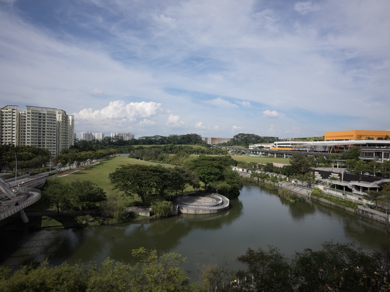
Scenic photography spots by Singapore LRT are easiest to find when a station guide names a real public viewpoint rather than simply promising ‘Instagram-worthy scenery’. The strongest combinations include Jewel Bridge, Kelong Bridge and Sunrise Bridge in Punggol Waterway Park, Punggol Point Park’s coastal viewing deck near PW3, the 290-metre Sengkang Riverside Bridge and constructed wetland near Farmway SW2 or Kupang SW3, and the Jalan Kayu shophouse street from Thanggam SW4. Each offers a different subject: bridge geometry, heritage, sea horizons, wetlands or old architecture.
NParks specifically identifies Jewel Bridge as a sunset spot and Sunrise Bridge as a sunrise-view location on the eastern side of Punggol Waterway Park. Those are distinct positions, not different names for one footbridge. For a coastal horizon, Punggol Point Park’s public ship-inspired deck is a better subject than a long walk to a vaguely labelled waterfront. For mangroves and freshwater habitat, Kupang’s approach to Sengkang Riverside Park is more relevant than pretending every Punggol station is next to the same wetland.
- Choose a subject: bridges, coastal horizon, constructed wetland, shophouses or modern civic architecture.
- Choose an entrance: a station name alone does not establish the public photo viewpoint.
- Safety first: public paths, privacy, weather and wildlife always take priority over the picture.
Which LRT station should a photographer choose?
- Dome bridge and golden-hour water: Damai PE7 or Punggol PTC for a planned approach to Jewel Bridge.
- Fishing-village-inspired structure: Punggol PTC or Damai PE7 for Kelong Bridge after locating it on NParks’ map.
- Sunrise-oriented waterway bridge: Damai PE7 or another verified East Loop approach to Sunrise Bridge; choose by the exact entrance.
- Open coastal horizon: Punggol Point PW3 — Punggol Point Park’s viewing deck.
- Wetland and elevated bridge: Kupang SW3 for Sengkang Riverside Park’s Visitor and Mangrove plots.
- Community and park landscape: Farmway SW2 for the park’s Civic plot and the sports precinct.
- Forest-edge texture and plants: Bangkit BP9 or Segar BP11 for different Zhenghua Nature Park entrances.
- Shophouse architecture and historic streets: Thanggam SW4 for Jalan Kayu.
- Modern civic architecture: Sam Kee PW1 for One Punggol from appropriate public areas.
- Northshore neighbourhood and coastal context: Samudera PW4 for public Northshore views, without assuming private roof access.
Definition lock: a public photo viewpoint is not an unrestricted filming site
A public viewpoint is an area where visitors may ordinarily stand or pass, such as a signed public park path or a coastal deck. It is not a guarantee that commercial filming, drone operation, lighting equipment or a large photo crew is permitted without conditions.
A protected or private area includes residential facilities behind access control, staff-only shop spaces, railway depots, active schools, sensitive nature habitats and some sections of cultural or religious institutions. The fact that an attractive building is visible from a path does not make its interior available for photography.
A scenic image depends on actual weather, timing, visibility, people and light. A location guide can accurately name a bridge and its setting without promising that your photograph will look like an edited image from another season or year.
Use simple personal photography methods on lawful public paths. Large tripods, organised commercial shoots or aerial photography may be subject to separate restrictions. If a planned activity goes beyond normal handheld visitor photographs, check the relevant NParks, site operator or CAAS requirements before attempting it.
1. Jewel Bridge: photograph geometry and water instead of chasing a promised sunset
NParks describes Jewel Bridge as named after its dome-shaped structure and highlights it as a place where visitors may catch sunset views. This is a grounded reason to choose the bridge as a subject, rather than describing every footbridge on the waterway as the same landmark.
For a phone photograph, try using the bridge’s curved structure as a frame. Find a position on the public path where the curve remains visible and there is enough space for pedestrians to pass. Avoid leaning over a railing or standing in the cycling line just to capture a lower angle.
Water reflections change according to wind, light and the direction of the sky. Calm water can reflect colours and shapes, while a cloudy day may produce a muted but still interesting photograph. Adjust the composition to what is present, not what an old promotional photo suggests should appear.
Do not claim that Jewel Bridge is immediately beside Damai’s fare gates. Punggol Waterway Park is large, so use the official map to identify the bridge and suitable park entrance. Allow time for the final walking route and the return.
If a family wants a simple outing, one bridge is enough. Photograph it from two safe public positions and discuss how the different angles change the image. There is no need to travel to every waterway feature in the same visit.
2. Kelong Bridge: show history through shape and surroundings
Kelong Bridge is described by NParks as resembling a kelong, an offshore fishing platform built on wooden stilts. Its design references Punggol’s historical fishing-village identity. That makes it useful for an architectural and storytelling photograph rather than just a general view of greenery.
Consider photographing the relationship between the bridge structure, the water and the nearby modern housing. The picture can communicate how an older livelihood is remembered through present-day urban design. Avoid claiming that the bridge itself is an original surviving fishing platform.
Look for straight structural lines or repeating patterns in the supports and railings. Move slightly along the public path until the lines lead towards the subject. If people are crossing, either allow them to pass or accept them as part of an ordinary public scene without identifying or photographing them intrusively.
Use a recent NParks park map to identify the bridge’s actual position before choosing the rail stop. It is not accurate to say that all themed Punggol Waterway bridges are within a short walk of one platform.
For a learning task, ask a child what feature of the bridge resembles a fishing platform. Explain what kelongs were used for, then compare that function with today’s recreational and pedestrian use. The photograph becomes a way of documenting design rather than just decoration.
3. Sunrise Bridge: timing is different from sunset photography
NParks identifies Sunrise Bridge on the eastern part of the park as a location offering views of the rising sun. This makes it a distinct subject from Jewel Bridge’s sunset association. A trip to photograph sunrise requires a different time-of-day and rail-service plan.
The park may be open 24 hours, but the LRT does not run continuously all night. If you intend to arrive before sunrise, check the first operating trains and the actual pedestrian route. Depending on the planned time, a rail journey may not be available early enough; choose a legal, safe alternative rather than assuming there is an all-night shuttle.
A beginner can also visit after sunrise and photograph the bridge’s form in morning light. There is no need to arrive in darkness to have a meaningful outing. Cloud cover may hide the sun, but the bridge and planted setting remain subjects.
Do not position a tripod where it blocks commuters, cyclists or park users. Avoid stepping into planted beds or standing near water without protection for the sake of a reflection.
One early-morning outing should have a realistic return and breakfast plan if needed. Keep weather, transport availability and the group’s comfort ahead of a photographic wish list.
4. Punggol Point PW3: a wide coastal horizon and working maritime backdrop
Punggol Point Park is a small coastal destination near Punggol Point PW3, with a ship-inspired public viewing deck and views across the Straits of Johor. The park’s setting can include open water, distant port activity, trees and people using the waterfront.
For a wide composition, place the horizon sensibly and include one foreground feature such as a public railing or path curve. The intention is to show the scale of the coast, not just an undifferentiated expanse of water. On a cloudy day, the industrial skyline can still make an interesting contrast with the park’s greenery.
Do not assume the shoreline is an empty natural wilderness; it is part of a busy maritime region. A cargo ship, port crane or distant built environment can be a truthful part of the photograph, rather than something that needs to be edited away.
The viewing deck is a shared public space. Keep paths clear, respect other visitors and do not stand on railings, leave children unattended or lean over the water. Safety is particularly important when sea wind and rain affect conditions.
From PW3, plan the onward public walking route and return. The deck is not in the station itself, and the coastal promenade may extend beyond what a young child or older person wants to walk. A short viewing stop is a complete outing.
5. Sengkang Riverside Park: wetlands, reflections and a long public bridge
NParks describes Sengkang Riverside Park as a 21.3-hectare site with a constructed wetland and Sengkang Riverside Bridge, a 290-metre crossing. It has different Visitor, Mangrove and Civic plots, with Kupang SW3 and Farmway SW2 recommended for different approaches.
Choose the plot that contains the view you actually want. For a constructed-wetland and mangrove-subject outing, Kupang is the better conceptual starting point. For civic park space and nearby community facilities, Farmway is useful. Official NParks guidance estimates about five minutes from the relevant LRT stop to the associated plot.
The wetland’s mix of water, grasses and trees can make interesting layers in an image. Try including a near plant, a middle-distance water feature and a far bridge. This gives depth without approaching wildlife closely or leaving the public trail.
NParks says the park’s pond areas are not wheelchair accessible, even though the wider park has accessible routes. Do not promise a wheelchair user the same water’s-edge photograph available from every side path. Choose a safe accessible public viewing position that fits the visitor.
Reflections are affected by water movement and weather. Birds and damselflies may appear, but they cannot be promised. Patient observation from a path is better than feeding animals to attract them.
6. Zhenghua Nature Park: photograph foliage, forest edges and small details
Zhenghua Nature Park is a 17.3-hectare linear green corridor with official entrances at Bangkit Road, Segar Road and Chestnut Avenue. NParks lists Bangkit, Fajar and Segar LRT as nearby stations. It is a better setting for vegetation, texture and quiet wildlife observation than for a big shopping-centre skyline.
Use soft light under the tree cover to look for leaf textures, changes in shade or the shape of a path. A phone camera can make a useful image of a public trail without any specialist lens. Try kneeling only where the path remains safe and clear, not on planted ground.
NParks records birds such as sunbirds and flameback woodpeckers in the park, but an animal may not appear during your visit. Do not chase a bird, play calls to lure wildlife, approach nests or use flash close to animals for a photograph.
The park’s linear length is around 2.5 kilometres, not a minimum route to complete. Choose one entrance and a comfortable out-and-back distance. A photography activity can be short and still lead to interesting observations.
If rain or lightning makes the park unsafe, postpone. A forest edge can become slippery, and an attractive wet-leaf photograph is not a reason to ignore closed paths or thunderstorm warnings.
7. Jalan Kayu: photograph old shophouse facades respectfully
Jalan Kayu near Thanggam SW4 has low-rise shophouses associated with the road’s RAF Seletar history. Government heritage material explains that the road was constructed in 1928 and names surviving 1950s shophouses with traditional exterior details.
A useful image can compare the scale of an older shophouse frontage with newer housing visible beyond it. Look at patterns in windows, shutters, signs and rooflines from a public sidewalk. This documents how a heritage street coexists with modern Sengkang.
Do not enter private upper floors, backrooms, kitchens or staff spaces. Avoid photographing people eating at close range without consent, particularly when a restaurant is busy. A working street should not be blocked for a long fashion-style shoot.
If travelling in the evening, choose a food outlet that is currently open and check return transport. A late restaurant hour does not guarantee the LRT still operates when you finish dinner.
One thoughtful photograph and a short historical explanation can be more educational than many images that treat the street as a decorative backdrop. Historical source accuracy matters as much as composition.
8. Modern Punggol architecture and the Northshore setting
One Punggol at 1 Punggol Drive is a modern civic hub near Sam Kee PW1, with a regional library, hawker centre and community facilities. Public-facing architecture can provide photographs about how public buildings bring activities together. The safest positions are normal public approaches and permitted outdoor areas.
Do not assume that a library interior, staff room or resident area can be photographed freely. Library rules, privacy needs and any organised filming policy may apply. Ask before setting up equipment or involving other visitors.
Northshore Plaza I and II in the Punggol Northshore precinct can be reached in the wider area served by Samudera PW4. The district offers a contrast between housing, shops and coastal context, but some viewing decks or roofs may belong to tenants or residents. Do not promise public access to private elevated spaces.
An architectural photograph can work well by focusing on repeating forms, building shadows and public spaces, without needing a rooftop. Keep perspectives truthful and avoid editing out essential safety boundaries or making a private site appear open.
Modern development is part of Singapore’s landscape story. The picture can show how public transport connects the built environment to parks and waterways, not just a collection of dramatic buildings.
9. Five simple phone-photography skills for LRT trips
Composition: place the main subject where the viewer can recognise it. At a long bridge, a railing can act as a leading line. At a park, a foreground plant can provide scale. There is no need to follow a rigid rule if a different arrangement better communicates the setting.
Light: photograph with the available weather rather than expecting one perfect glow. Early and late light often creates longer shadows, but cloud cover can provide soft, even lighting that works especially well for trees and architecture.
Perspective: compare a wide frame with a more focused one from the same lawful public position. Moving a small distance along a path can change the relationship between a tree, bridge and distant housing without putting anybody in danger.
Stability: hold the phone with both hands and brace yourself where appropriate. If the light is low, be patient and take several images, but do not use a handrail as a place to balance equipment where it could fall into the water.
Editing: modest adjustments to brightness, crop or contrast can improve clarity. When publishing a guide or school project, distinguish edited artistic images from documentary photographs and avoid presenting composites as real on-site observations.
10. Photographing wildlife and people ethically
Wildlife is not a studio subject. Do not feed or lure birds and fish, remove plants, approach nesting areas or enter sensitive wetlands to improve a shot. A respectful photograph from a designated path can be more valuable than a close-up obtained by disturbing an animal.
Photographing a busy public street calls for consideration. If an individual is the focus, ask permission where appropriate; do not follow strangers or capture children at school entrances intrusively. Restaurant, library, hospital and religious interiors can have additional rules.
Public transport stations are busy shared infrastructure. Do not block the escalator landing or take a shot while standing too close to a platform edge. Railway depots, staff areas and restricted platforms are not public photography destinations.
Large shoots, drones, lighting installations and commercial activity may require permits from site managers or relevant authorities. Do not assume that a handheld personal photograph and a film crew have the same permissions.
A student making a school photo essay should record the place, date, what was actually seen and which historical detail came from a source. This protects against false claims and helps others understand the image’s context.
11. Three practical photography itineraries
Waterway architecture, one bridge only
- Choose Jewel Bridge, Kelong Bridge or Sunrise Bridge on NParks’ current park map.
- Select the LRT approach and public entrance, then plan an out-and-back with enough return time.
- Make one wide shot, one detail shot and one photograph explaining the setting.
- Leave other bridges for a separate visit instead of rushing across the whole park.
A focused bridge outing makes it easier to learn composition and stay safe.
Coastal horizon and one public deck
- Travel to Punggol Point PW3 and use the public path towards Punggol Point Park.
- Photograph one public coastal viewpoint and a detail such as the deck structure.
- Check sea weather and leave if thunder, heavy rain or unsafe wind develops.
- Return without attempting an entire promenade or restricted jetty area.
The coast is worth photographing even without a dramatic orange sky.
Wetland texture and urban nature
- Choose Kupang SW3 for Sengkang Riverside Park’s Visitor and Mangrove plots.
- Use public paths and keep away from inaccessible pond edges.
- Look for a water-and-vegetation composition and record what you actually observe.
- Return at a comfortable pace; do not promise a specific bird or otter sighting.
This activity focuses on habitat observation rather than photographing wildlife on demand.
12. Common scenic photography mistakes
- Assuming Jewel, Kelong and Sunrise bridges are the same place.
- Claiming the entire Punggol Waterway Park is a five-minute walk from one LRT platform.
- Expecting a guaranteed sunset colour, wildlife species or clear sky.
- Going onto private roof decks or residential property for an elevated viewpoint.
- Standing over a bridge railing or blocking a shared promenade with equipment.
- Using flash or playback to disturb wildlife for a closer photograph.
- Treating a park’s 24-hour opening as advice to walk unknown trails at night.
- Posting an edited composite as a documentary on-site photograph.
- Taking pictures of schoolchildren or patients intrusively.
- Attempting drone photography without checking all applicable site and aviation rules.
Frequently asked questions about photography by LRT
Which LRT station is good for Punggol Waterway photographs?
Damai PE7 or Punggol PTC/NE17, depending on the exact bridge and park entrance you choose.
What is special about Jewel Bridge?
NParks describes its dome-shaped design and specifically highlights sunset views.
Is Sunrise Bridge the same as Jewel Bridge?
No. Sunrise Bridge is a different bridge on the eastern side of Punggol Waterway Park.
Which LRT station serves Punggol Point Park?
Punggol Point PW3, with a public onward walk to the coastal park.
Where can I photograph constructed wetlands?
Sengkang Riverside Park, with Kupang SW3 serving the Visitor and Mangrove plots.
What is Sengkang Riverside Bridge?
NParks describes a 290-metre bridge with elevated views across the park and water.
Where can I photograph shophouses?
Jalan Kayu from Thanggam SW4, from lawful public footpaths.
Can I take a drone to these parks?
Do not assume permission. Check current CAAS requirements, airspace restrictions and site-specific permissions before any drone flight.
Are wildlife sightings guaranteed?
No. Animal presence depends on conditions and should never be manipulated by feeding or disturbance.
Can I set up a tripod on a bridge?
Only where allowed and safe, without obstructing other users. Check site rules for commercial or large shoots.
Is a phone good enough?
Yes. Composition, stable handling and safe viewpoints often matter more than specialised equipment.
Can I photograph people at a public mall?
Respect privacy, obtain consent when appropriate and follow property rules; do not intrude on children or private activities.
Official sources and linked station guides
- NParks Punggol Waterway Park: three named bridges and visitor information
- NParks Punggol Point Park and public viewing deck
- NParks Sengkang Riverside Park: 290 m bridge, wetlands and plots
- NParks Zhenghua Nature Park and bird habitat
- Singapore Government: Jalan Kayu shophouse history
- OnePA: One Punggol and Sam Kee access
- CAAS official aviation and unmanned aircraft information
- Complete 42-station Singapore LRT Guide
- Singapore LRT nature and parks theme guide
Reviewed 1 November 2026. Public park views, wildlife, sunset lighting, pedestrian routes and photography permissions are conditional on weather and operating rules. An official park description is not permission to enter private property, restricted railway areas or sensitive habitat.