
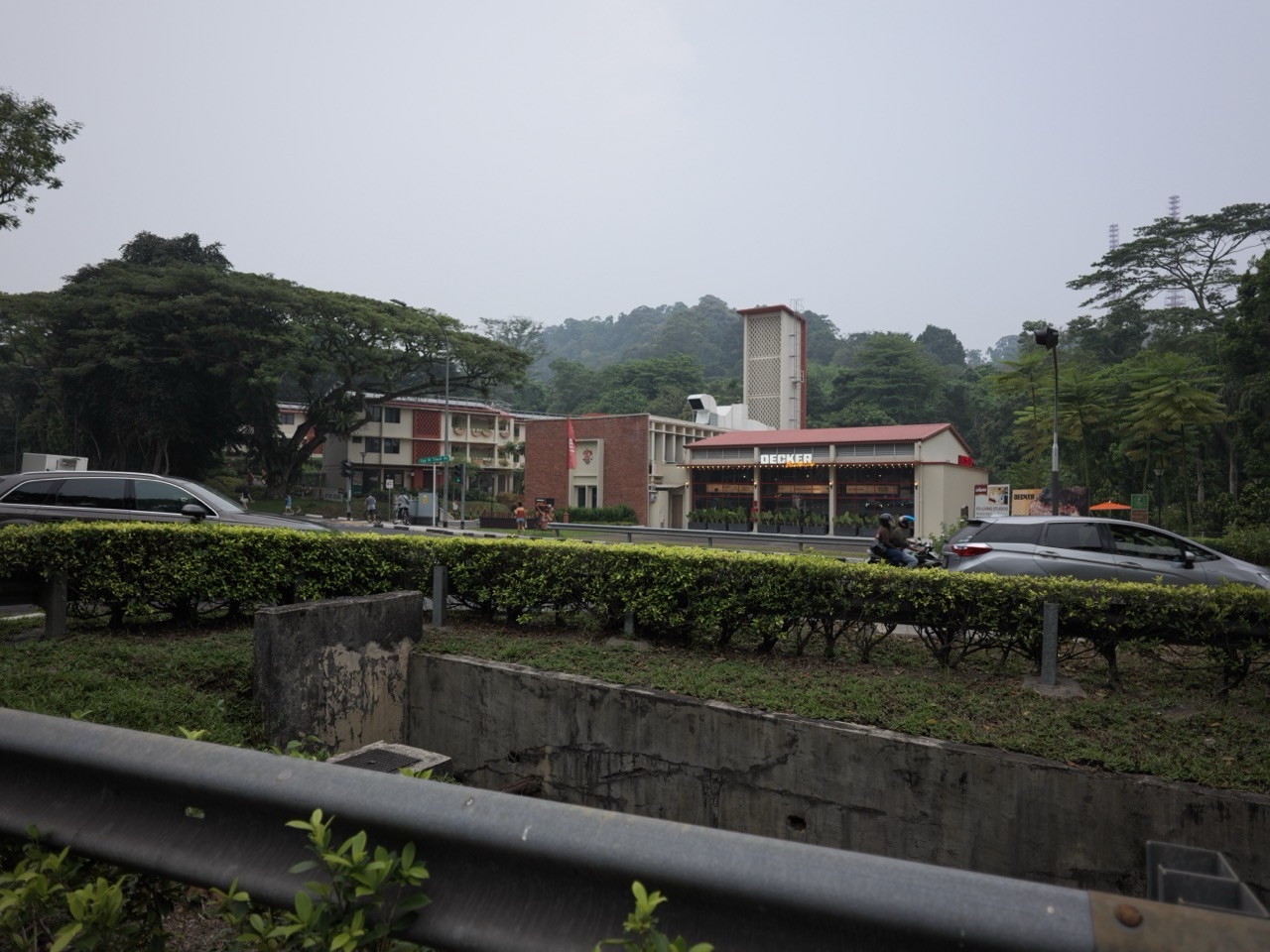
Did you know that a building can stop fighting fires yet remain an important part of the neighbourhood? The former Bukit Timah Fire Station is one of the clearest examples of adaptive reuse around Upper Bukit Timah.
For decades, the fire station helped protect the district, including an area once associated with quarrying and industrial activity. Today, the distinctive tower and station buildings are part of a co-living and community-oriented destination rather than an operating emergency-response station.
The quick answer in October 2026: The former station at 260 Upper Bukit Timah Road was built in 1956, ceased its original operations in 2005 and is conserved. A new community and co-living use opened in 2025. The site also forms part of longer-term plans for better links between the Rail Corridor and neighbouring nature parks.
Featured photograph shows the former Bukit Timah Fire Station exterior and dining activity; retail tenants and operating hours may change.
In this guide: Why was a fire station needed here? · What does it mean for a building to be conserved? · Why give an old fire station a new purpose? · What actually opened by 2025? · How does the Rail Corridor fit into the plan? · What are the trade-offs in reusing a public landmark? · What should visitors know before going?
1. Why was a fire station needed here?
The Upper Bukit Timah area was not always the mostly residential and recreation-focused district people recognise today. Older quarry operations, industrial activity, main roads and scattered settlements created a different set of emergency risks.
A fire station operates as part of a wider response network. Location matters because crews and vehicles need to reach emergencies quickly. The building’s familiar tower, training spaces and accommodation areas reflected a working station rather than a decorative landmark.
The former Bukit Timah Fire Station opened in 1956. It remained operational for 49 years, before decommissioning in 2005. Its presence is a clue to how the district’s public services adapted to growth.
2. What does it mean for a building to be conserved?
The Urban Redevelopment Authority lists the former fire station as a conserved site. Conservation does not mean the property must stay frozen in its original operational role. It means historically significant features need protection and any additions or changes must follow conservation requirements.
URA’s site-specific guidance covers features including the former residential fronts, timber casement windows and double-leafed timber doors where required. Such details matter because they record how a public-service building was designed and used at a particular time.
Keeping a recognisable building can strengthen local identity. A landmark makes different periods of the neighbourhood easier to compare: residents may remember the active fire station, while younger visitors know its new shops or community activities.
3. Why give an old fire station a new purpose?
Repurposing existing buildings is called adaptive reuse. Instead of starting again with an empty site, designers work with what already exists. Former garage-like spaces may become retail or activity areas; accommodation can support new forms of stay or shared use.
The approach can preserve heritage character and, depending on the project, avoid some of the materials and disruption involved in complete demolition. But reuse still requires proper fire safety, accessibility, building services and conservation approvals.
Government planning has treated the former station as a potential gateway to nature and heritage. It is close to parts of the Rail Corridor and recreational landscapes such as Bukit Batok Nature Park, so its new use can support more than the people staying within the site.
4. What actually opened by 2025?
URA’s current Rail Corridor information states that a community space for recreation, learning and co-living opened in 2025. The premises operate under the Coliwoo Bukit Timah Fire Station name.
Contemporary reporting describes furnished accommodation, shops, food and beverage offerings and spaces for workshops or gatherings. The exact mix of operators and their session times can change. Do not assume that a programme described in a launch article runs every day or is included with general site access.
One reason the transformation is interesting is its mixed-use structure. Short-stay or longer-term residents, people meeting friends and families attending an activity may share parts of the same site without having the same purpose for visiting.
5. How does the Rail Corridor fit into the plan?
The former fire station is not isolated from surrounding planning. URA describes it as a node along the wider Rail Corridor identity corridor, intended to help connect people with nearby nature and heritage destinations.
URA also states that a visitor centre and an eco-pedestrian bridge are among the next-phase plans, with a proposed connection through the former fire station area toward Bukit Batok Nature Park.
That distinction is important: the community and co-living hub is already operating, while the additional visitor centre and bridge are still plans in the current URA description. Do not follow a map that shows a proposed bridge as though it were an open public crossing.
6. What are the trade-offs in reusing a public landmark?
Converting a former emergency-service site into a community destination creates opportunities, but planners must balance several interests. Historical authenticity matters; so do safe circulation, deliveries, nearby residential amenity and financial viability.
A conserved tower may be a strong visual symbol but have little practical capacity for modern uses without careful work. Shared spaces can invite visitors, while residential accommodation may require controlled access and privacy.
These decisions are part of how a city evolves. An old building can remain recognisable without preserving every old function. Its meaning is expanded rather than simply replaced.
7. What should visitors know before going?
A useful field exercise is to sketch three versions of the same place: 1956, 2005 and 2026. Which physical structures remained? Which functions changed? What new connections are proposed? This simple timeline makes conservation and land-use planning far easier to understand.
The building tells a broader Bukit Timah story: as neighbourhood needs shift, valuable infrastructure sometimes survives by learning to do a different job.
- The address is 260 Upper Bukit Timah Road, near Hume MRT on the Downtown Line.
- Check current Coliwoo Bukit Timah Fire Station visitor and activity listings rather than relying on old event dates.
- Respect the difference between public retail or activity areas and private accommodation.
- Use authorised public routes to reach nearby nature sites; planned infrastructure may not yet be open.
- To learn about the area’s wartime history, the Former Ford Factory is a separate heritage location, not part of the fire station.
Frequently asked questions
Is Bukit Timah Fire Station still an operating fire station?
No. The original station ceased operating in 2005. The conserved site now houses community-oriented and co-living uses.
When did Coliwoo Bukit Timah Fire Station open?
URA reports that new recreation, learning and co-living community uses opened in 2025.
Where is the former Bukit Timah Fire Station?
It is at 260 Upper Bukit Timah Road, near Hume MRT station.
Is the new eco-pedestrian bridge open?
URA describes the additional visitor centre and eco-pedestrian bridge as plans for a future phase; check current official route information before assuming access.
Official sources and further reading
Official sources help distinguish established facts from plans and changing visitor arrangements. For current access, operating hours and development schedules, check the responsible authority.
- URA: 260 Upper Bukit Timah Road conservation record
- URA: Rail Corridor, including the former Bukit Timah Fire Station node
- URA: Former Bukit Timah Fire Station community node
- The Smart Local: Coliwoo Bukit Timah Fire Station visit, October 2026
Keep exploring how Bukit Timah works
- How Bukit Timah Works | Why Granite, Quarries and Hills Shaped the Area
- How Bukit Timah Works | How the Rainforest Survives Inside Singapore
- How Bukit Timah Works | How the Rail Corridor Connects History and Nature
- How Bukit Timah Works | Why Schools and MRT Stations Follow the Main Road
- How Bukit Timah Works | Why Floods Happen and How the 2026 Canal Upgrade Helps
- How Bukit Timah Works | How Beauty World Grew from a Market into a Town Centre
- How Bukit Timah Works | How Kampongs, Temples and Fuyong Estate Shaped the Neighbourhood
- How Bukit Timah Works | Why Bukit Timah Was Crucial in World War II
- How Bukit Timah Works | How Dairy Farm Became a Nature Park
- How Bukit Timah Works | Why Hawkers Moved to an Interim Market
- How Bukit Timah Works | How the Former Fire Station Became a Community Hub (you are here)
- How Bukit Timah Works | Why Singapore Botanic Gardens Is UNESCO Heritage